Environmental Impact Statement Chapter 1.0 Introduction
Table of contents
Accessibility
This digital version of the EIS is designed to be accessible to all users, providing screen reader compatibility, keyboard navigation, and described images. If you require additional assistance or have specific accessibility needs, please contact us at lightrailtowoden@act.gov.au or call 1800 956 409.
1.0 Introduction
1.1 Light rail vision
The Light Rail network is a keystone project to deliver on the community objectives outlined within ACT Government strategies, to shape Canberra's future to be a more compact, competitive, and connected city.
The ACT Government announced in Canberra: A Statement of Ambition 2016 that a key direction of travel to guide policy making efforts is to 'deliver better metropolitan infrastructure that helps to renew our inner precincts, strengthening our suburbs and providing new opportunities for all' (CMTEDD, 2016).
In 2020, the ACT Government's Transport Strategy 2020 presented a vision to deliver Light Rail to develop a world-class transport system that would support a more compact, sustainable, and vibrant city (TCCS, 2020a). Light rail would boost Canberra's sustainable growth by changing and improving transport options, settlement patterns and employment opportunities (CMTEDD, 2016).
The ACT Infrastructure Plan sets out a long-term vision to build Canberra's future. Revised in 2024 with a transport update, the plan emphasises continued investment in the light rail as a cornerstone of public transport infrastructure to service a modern, growing city. It reinforces the vision for a 'connected and convenient public transport network' to encourage more Canberrans to make public transport part of their everyday lives. Light rail will help deliver a more compact, walkable and liveable city, enable more accessible services and connect communities between the north and southside of the City (ACT Government, 2024a).
1.2 Background
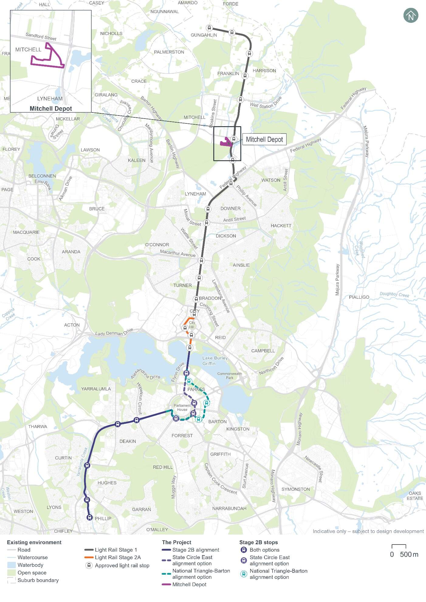
Light Rail Stage 1 (LRS1) is currently operational from Gungahlin Place, Gungahlin, to Alinga Street, in the city centre, as shown on Figure 1-1. LRS1 includes 12 kilometres (km) of light rail track, 14 stops, 14 light rail vehicles (LRVs), and a maintenance depot in Mitchell. LRS1 provides a sustainable, accessible, and affordable public transport option. Between January to March 2024, LRS1 was boarded, on average, around 13,950 times during weekdays, and 7,550 times during weekends (TCCS, 2024a).
Building on the success of LRS1, the ACT Government has committed to continuing to improve connectivity in Canberra by extending the current Light Rail network to Woden Town Centre (Figure 1-1). The extension of the Light Rail network from the city centre to Woden Town Centre has been separated into two projects. The first stage is Light Rail Stage 2A (LRS2A), and the second is Light Rail Stage 2B (the Project). The raising of London Circuit between Edinburgh Avenue and Constitution Avenue to provide a new at-grade, signalised intersection with Commonwealth Avenue, forms part of the LRS2A project as facilitating works.
LRS2A and the Project are shown on Figure 1-1.
LRS2A has been approved and is currently being constructed. LRS2A will connect Alinga Street (the current city centre terminus) to a stop at Commonwealth Park. LRS2A will deliver a 1.7 km extension to the existing Light Rail network, and three stops at Edinburgh Avenue, City South, and Commonwealth Park.
Detail on the strategic need and justification for the Project is included in Chapter 2 (Need for the Project).
1.3 Project overview
In this context, the proponent, Infrastructure Canberra (iCBR), is seeking approval for the construction and operation (including maintenance) of the next stage of the Light Rail network from the approved LRS2A Commonwealth Park Stop on Commonwealth Avenue, to a new terminus on Callam Street at Woden Town Centre (the Woden Interchange). The Project would be an extension of the existing LRS1 and the approved LRS2A.
The Project would deliver a light rail alignment across Lake Burley Griffin, through the National Triangle, along Adelaide Avenue, and Yarra Glen, before terminating at Woden Town Centre. The light rail depot at Mitchell would also be expanded, new bridges constructed and associated infrastructure developed. Further details of the Project are described in Chapter 5 (Project description) and Chapter 6 (Construction).
Two potential alignments for the Project are being considered through the National Triangle and around Parliament House, and have been assessed in this Environmental Impact Statement (EIS). These alignment options include:
- The State Circle East alignment option: from Commonwealth Avenue along State Circle to Adelaide Avenue (shown in purple dotted lines on Figure 1-1)
- The National Triangle-Barton alignment option: from Commonwealth Avenue along King George Terrace, Macquarie Street, Bligh Street, National Circuit, and Sydney Avenue, before connecting with State Circle to Adelaide Avenue (shown in teal dotted lines on Figure 1-1).
However, only one of the two alignment options above would be constructed. The selection of an alignment option for the Project (i.e. the National Triangle-Barton alignment option or the State Circle East alignment option) will consider factors including:
- Place outcomes
- Community and stakeholder feedback on the draft EIS
- Potential environmental and social benefits and impacts.
The revised, final EIS will describe only one alignment option, and will identify potential environmental impacts and benefits of that option.
Subject to Commonwealth and ACT planning approval and a subsequent ACT Government investment decision, the first passenger services on the Project are proposed to commence in 2034.
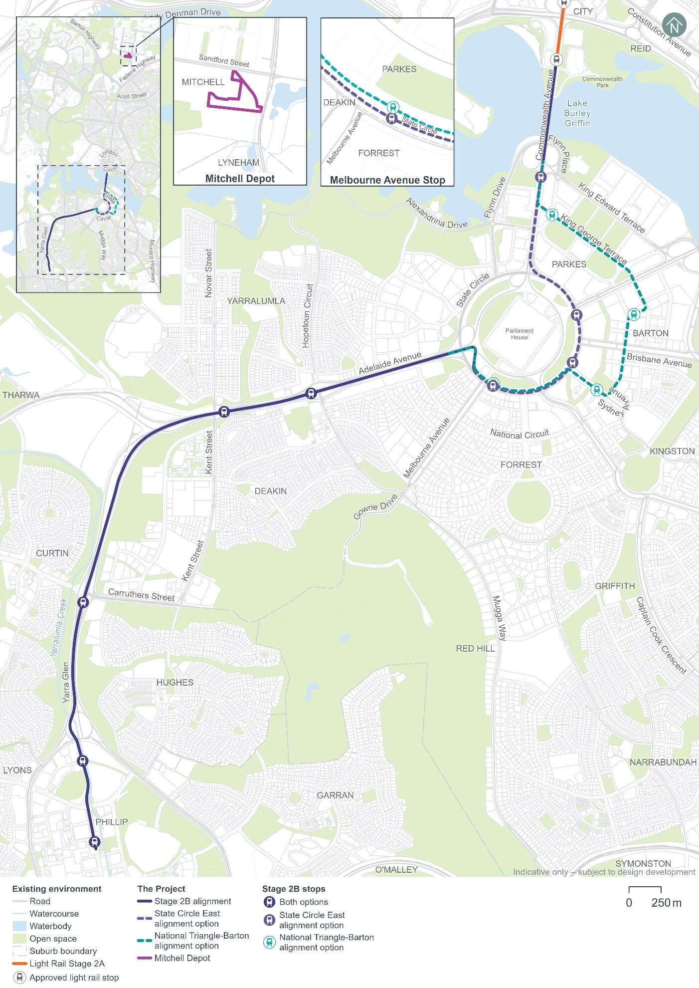
The Project, including each alignment option, is shown on Figure 1-2. Key features of the Project are outlined in Table 1-1. Preparation of the EIS has been based on the Project at a concept design stage. The Project would be subject to ongoing design development and the final design may vary from that presented in this EIS. Further design development would integrate with other planned projects, such as those in the ACT Infrastructure Plan, and emerging projects (e.g. Southern Gateway Planning and Design Framework and active travel projects), however, these projects are not within the EIS scope.
| Project feature | Description | |
|---|---|---|
| State Circle East alignment option | National Triangle-Barton alignment option | |
|
Light rail track |
A new light rail track around 9.5 km in length, connecting from the approved Commonwealth Park Stop (LRS2A), crossing over Lake Burley Griffin, travelling along the median of Commonwealth Avenue and passing on the eastern side of Parliament House in the median of State Circle. |
A new light rail track around 10.5 km in length, connecting from the approved Commonwealth Park Stop (LRS2A), crossing over Lake Burley Griffin, leaving Commonwealth Avenue to travel east along King George Terrace, Macquarie Street, Bligh Street, National Circuit, Sydney Avenue, and moving to inner running on State Circle. |
|
From State Circle, both alignment options would transition onto Adelaide Avenue via the landscaped annulus between State Circle and Capital Circle before travelling along Adelaide Avenue and Yarra Glen, with a new terminus at Woden Town Centre (Woden Interchange). |
||
|
Light rail stops |
A total of nine new light rail stops and ancillary infrastructure. |
|
|
Bridges |
|
|
|
Covered section |
A covered section about 125 m long where the light rail would pass beneath the southbound lanes of Commonwealth Avenue and transition onto the median of State Circle. |
There would be no covered sections in the National Triangle-Barton alignment option. |
|
Active travel arrangements |
Reconfiguration, modification and replacement of existing active travel (walking, cycling, and micromobility) infrastructure at various locations, and connection to existing active travel infrastructure within the Project area. New active travel arrangements would include four new pedestrian and cyclist bridges, shared paths to connect with the existing and/or planned active travel network, and bike/scooter parking at stop precincts. |
|
|
Landscaping and public domain works |
Landscaping and public domain features along and around the Project alignment, as presented in the Public Domain Master Plan (refer to Appendix I). |
|
|
Road network changes |
Road network changes to accommodate the Project, including modifications to existing road carriageways and intersections, new intersection arrangements, changes to line markings and traffic signal phasing. |
|
|
|
|
|
Other facilities and infrastructure |
|
|
|
Operation and maintenance |
Operation and maintenance of the Project, including operation, storage and maintenance of up to 12 additional LRVs on the Light Rail network. |
|
1.4 Purpose and structure of this Environmental Impact Statement
This document is a draft EIS, prepared for public notification (exhibition) and referral to relevant entities. Following the exhibition period, a revised, final EIS will be prepared and published, which will:
- Address comments, public submissions, and representations received
- Document any changes to the Project since this draft EIS was exhibited.
Throughout this document, the draft EIS is referred to as 'the EIS'.
The purpose of the EIS is to describe the Project and existing environment, and to identify and assess the Project's potential impacts to the environment. Where applicable this EIS identifies measures that would be implemented to avoid, minimise, manage, mitigate, offset, and/or monitor the potential impacts of the Project.
The EIS has been prepared to comply with the:
- The ACT Government's Territory Planning Authority Scoping Document requirements dated 4 March 2024, provided under the Planning Act 2023 (ACT) (Application number: 202400003)
- The Commonwealth Department of Climate Change, Energy, the Environment and Water's (DCCEEW) Guidelines for the Content of a Draft EIS (EIS Guidelines), dated 25 July 2024, in accordance with the Environment Protection and Biodiversity Conservation Act 1999 (Cth) (EPBC Reference: 2023/09753).
The structure and content of the EIS is summarised in Table 1-2.
The EIS has adopted a precinct-based approach to the environmental assessment of the construction and operational impacts of the Project. The precinct-based approach responds to the linear nature of the Project, and the unique environmental and stakeholder contexts of areas along the Project alignment.
The Project has been separated into seven precincts (across both Project alignment options) based on common environmental and stakeholder contexts. The Mitchell Depot site has also been considered in addition to the precincts along the Project alignment. Chapter 9 (Approach to the environmental assessment) identifies the precincts and provides further detail on the precinct-based assessment approach.
| Part/chapter | Description of contents |
|---|---|
|
Part A - Introduction and context |
|
|
Chapter 1 (Introduction) |
The introduction and background to the Project, an overview of the Project and structure of this EIS. |
|
Chapter 2 (Need for the Project) |
The strategic need for the Project, as well as the objectives and benefits of the Project. |
|
Chapter 3 (Project development) |
How the design of the Project has been developed, including alternatives and design options that have been considered. |
|
Chapter 4 (Stakeholder and community consultation) |
Stakeholder and community engagement that has been carried out in relation to the Project, key issues that have been raised, and where these issues have been addressed. |
|
Chapter 5 (Project description) |
A description of the Project and how the Project would be operated. |
|
Chapter 6 (Construction) |
A description of how the Project would be constructed. |
|
Chapter 7 (Sustainability) |
An overview of the Project's sustainability approach. |
|
Chapter 8 (Legislation and policy) |
The legislative and policy context of the Project and the environmental and planning approvals that would be required to carry out the Project. |
|
Chapter 9 (Approach to the environmental assessment) |
How the EIS has been developed including the methodology for the environmental risk analysis undertaken for the Project and the precinct-based approach of the EIS. |
|
Chapter 10 (Assessment methodologies) |
The assessment methodology for each environmental issue. |
|
Part B - Environmental impact assessment |
|
|
Chapter 11 (Project-wide issues) |
An assessment of environmental issues resulting from the construction and operation of the Project, where these are not precinct-specific and/or are applicable to the Project as a whole. |
|
Chapter 12 (Commonwealth Avenue precinct) |
An assessment of environmental issues resulting from the construction and operation of the Project, of relevance to the Commonwealth Avenue precinct. |
|
Chapter 13 (Parliament House precinct) |
An assessment of environmental issues resulting from the construction and operation of the Project, of relevance to the Parliament House precinct. |
|
Chapter 14 (National Triangle precinct) |
An assessment of environmental issues resulting from the construction and operation of the Project, of relevance to the National Triangle precinct. |
|
Chapter 15 (Barton precinct) |
An assessment of environmental issues resulting from the construction and operation of the Project, of relevance to the Barton precinct. |
|
Chapter 16 (Inner South precinct) |
An assessment of environmental issues resulting from the construction and operation of the Project, of relevance to the Inner South precinct. |
|
Chapter 17 (Yarra Glen precinct) |
An assessment of environmental issues resulting from the construction and operation of the Project, of relevance to the Yarra Glen precinct. |
|
Chapter 18 (Woden precinct) |
An assessment of environmental issues resulting from the construction and operation of the Project, of relevance to the Woden precinct. |
|
Chapter 19 (Mitchell Depot site) |
An assessment of environmental issues resulting from the construction and operation of the Project, of relevance to the Mitchell Depot site. |
|
Chapter 20 (Cumulative impacts) |
An assessment of the potential cumulative impacts as a result of the operation and construction of the Project. |
|
Part C - Environmental management and conclusion |
|
|
Chapter 21 (Environmental management and mitigation measures) |
A consolidated list of management and mitigation measures that would be adopted. |
|
Chapter 22 (Summary of assessment and residual impacts) |
Provides a summary of the assessment outcomes and residual impacts, with respect to matters relevant to the assessment of this EIS under the Environment Protection and Biodiversity Conservation Act 1999 (Cth) (EPBC Act) and the Planning Act 2023 (ACT) (Planning Act). |
|
Chapter 23 (Justification and conclusion) |
Conclusions of the EIS and the justification for carrying out the Project. |
|
Part D - Appendices and technical reports |
|
|
Appendix A |
Glossary and abbreviations |
|
Appendix B |
Scoping Document |
|
Appendix C |
EIS Guidelines |
|
Appendix D |
EIS cross references |
|
Appendix E |
Proponent's environmental history |
|
Appendix F |
Information sources and references |
|
Appendix G |
Study team |
|
Appendix H |
Consultation |
|
Appendix I |
Public Domain Master Plan |
|
Appendix J |
Environmental risk assessment |
|
Appendix K |
Property and land use planning |
|
Appendix L |
Environmental Management Plan outline |
|
Technical Report 1 |
Traffic and transport |
|
Technical Report 2 |
Biodiversity |
|
Technical Report 3 |
Heritage |
|
Technical Report 4 |
Hydrology, flooding and water quality |
|
Technical Report 5 |
Contamination |
|
Technical Report 6 |
Socioeconomic |
|
Technical Report 7 |
Climate change risk |
|
Technical Report 8 |
Greenhouse gas |
|
Technical Report 9 |
Noise and vibration |
|
Technical Report 10 |
Landscape character and visual amenity |