Environmental Impact Statement Chapter 14.0 National Triangle precinct
Table of contents
Accessibility
This digital version of the EIS is designed to be accessible to all users, providing screen reader compatibility, keyboard navigation, and described images. If you require additional assistance or have specific accessibility needs, please contact us at lightrailtowoden@act.gov.au or call 1800 956 409.
14.0 National Triangle precinct
This chapter provides an assessment of potential impacts during operation and construction that relate to the National Triangle precinct, and identifies mitigation measures to address these impacts. Environmental issues assessed in this chapter include:
- Traffic and transport (Section 14.1.4)
- Noise and vibration (Section 14.3)
- Biodiversity (Section 14.4)
- Historic heritage (Section 14.5)
- Landscape character and visual amenity (Section 14.6)
- Socioeconomic impacts (Section 14.7).
The assessment of some aspects of traffic and transport, biodiversity, historic heritage, and socioeconomic impacts are applicable to the Project as a whole. These aspects have also been assessed in Chapter 11 (Project-wide issues).
Some additional environmental issues relevant to this precinct have been considered at a Project-wide level only in Chapter 11 (Project-wide issues), as the potential impacts and management approach associated with the issue are applicable to the Project as a whole.
14.1 Overview
The National Triangle precinct encompasses the area generally between Commonwealth Avenue and Kings Avenue. This precinct is within the National Triangle and Parliamentary Zone, and is adjacent to Old Parliament House and the Aboriginal Tent Embassy, with views across the lake to the Australian War Memorial, and Mount Ainslie in the background. Nearby are Australia's most significant cultural and governmental institutions such as the High Court of Australia, National Gallery of Australia, National Library of Australia, and the National Science and Technology Centre (Questacon).
14.1.1 State Circle East alignment option
There would be no operational light rail infrastructure within the National Triangle precinct for the State Circle East alignment option.
14.1.2 National Triangle-Barton alignment option
For this option, the light rail alignment would traverse King George Terrace from Commonwealth Avenue to its intersection with Kings Avenue. Part of King George Terrace would be transformed into a shared space by closing vehicular traffic between Parkes Place East and Parkes Place West, creating a forecourt setting to Old Parliament House. King George Terrace between Parkes Place East and Kings Avenue would also be closed to vehicle traffic. The light rail would be within the road median (median running), with the exception of a section of the alignment between Commonwealth Avenue and Langton Crescent where the alignment would be located away from the road reserve.
Treasury Stop is proposed at the intersection of King George Terrace and Langton Crescent. At this intersection Langton Crescent would be closed to vehicular traffic.
Within the National Triangle precinct, light rail would be wire-free.
Key Project features within this precinct for the National Triangle-Barton alignment option are shown in Figure 14-1.
Refer to Chapter 5 (Project description) for a more detailed description of the Project within this precinct.
14.1.3 Key construction activities
Construction activities required within this precinct would be generally similar to those required across other precincts. Construction activities are considered at a Project-wide level within Chapter 6 (Construction).
Some adjustments to traffic signals would be required on King Edward Terrace at its intersection with Parkes Place East and Parkes Place West. These areas are shown in Figure 6-1 in Chapter 6 (Construction).
Construction compounds within National Triangle precinct include:
- Compound D: 21 Queen Victoria Terrace Parking
- Compound E: King George Terrace and Kings Avenue.
The location of these compounds is shown in Figure 6-1 in Chapter 6 (Construction).
14.1.4 Environmental impact overview - construction
Key impacts within the National Triangle precinct from the construction of the Project are summarised below, and assessed in further detail in this precinct-based assessment chapter.
Two potential alignments options are being considered for the Project - the State Circle East alignment option and the National Triangle-Barton alignment option. The potential impacts of each alignment option have been assessed in this chapter. While construction activities for the State Circle East alignment option may include works in this precinct, the operational light rail alignment for State Circle East would not extend into this precinct. Through further design development and the selection of a single, final alignment option, environmental impacts are expected to be further minimised.
Traffic and transport
Construction of the Project would be undertaken within and adjacent to the road reserve, and as such would result in traffic impacts, including temporary road closures, changes to turning movements, and the introduction of heavy vehicle traffic, which would disrupt the road network and parking availability. Broader road network impacts are assessed in Chapter 11 (Project-wide issues).
Within this precinct, specific impacts attributed to the construction of the National Triangle-Barton alignment option would include the closure of King George Terrace between Langton Crescent and Kings Avenue, and local area access diversions, which may result in increased travel times for motorists.
Construction would also lead to a temporary, staged loss of up to 129 on-street parking spaces and five bus zones across the precinct as construction works progress. Construction compound D would result in the temporary loss of all 32 off-street spaces within the 21 Queen Victoria Terrace car park.
Activity- and site-specific traffic management measures would be developed and implemented through the Construction Environmental Management Plan(s) for the Project, with a focus on managing construction-related traffic and site access, parking availability, and the adequate performance of the road network in proximity to construction site accesses and haulage routes. Notwithstanding, construction would result in residual traffic impacts following the implementation of these measures. Construction planning would continue with the aim of minimising disruption to the road and transport networks.
Noise and vibration
Construction activities, including earthworks, the decommissioning of utilities, are expected to generate noise that could moderately affect nearby non-residential buildings, particularly during 'peak' construction scenarios, which represent the noisiest works requiring the use of noise-intensive equipment such as concrete saws and rock breakers. Non-residential receivers located adjacent to the proposed haulage routes on parts of King George Terrace and Langton Crescent would be potentially affected by the increases in road traffic noise levels in instances where night works are required.
Mitigation measures that would be implemented to manage impacts, such as scheduling to minimise high-noise activities outside of standard construction hours, are expected to reduce the identified potential impacts. Works outside of standard hours would also require assessment and approval on a case-by-case basis. Despite these measures, some temporary disturbances are anticipated, but they are expected to be minimised through effective construction planning and community consultation.
Biodiversity
The Project design has been developed with the aim of avoiding direct and indirect impacts to Matters of National Environmental Significance (MNES) and other biodiversity values in the landscape by minimising the construction footprint. Despite this, some clearing of native vegetation and habitat for species protected under the Environment Protection and Biodiversity Conservation Act 1999 (Cth) (EPBC Act) and the Nature Conservation Act 1992 (ACT) (NC Act) would be required to construct and operate the Project. This would include a total of 0.89 hectares of vegetation within the National Triangle precinct, 0.08 hectares of which is characterised as native. Removal of this vegetation would impact foraging habitat for the Gang-gang Cockatoo (Callocephalon fimbriatum) (listed as endangered under the EPBC Act and NC Act) and Superb Parrot (Polytelis swainsonii) (vulnerable under the EPBC Act and NC Act), and breeding and foraging habitat for the Diamond Firetail (Stagonopleura guttata) (vulnerable under the EPBC Act and NC Act). The Project would also require the removal of around 0.23 hectare of high-density Chilean needlegrass that may provide suitable habitat for the Golden Sun Moth (Synemon plana) (vulnerable under the EPBC Act and the NC Act). Three mature native trees, which provide suitable breeding and/or foraging habitat for woodland birds, have also been identified in the proposed clearance footprint within the National Triangle precinct.
Opportunities to further avoid or minimise biodiversity impacts, and to enhance habitat and connectivity through Project landscaping would be considered through ongoing design development. A Biodiversity Offset Strategy has been developed for the Project to manage residual impacts which are unable to be avoided, and would be updated to reflect any further avoidance or minimisation of biodiversity impacts achieved through ongoing design development.
Other impacts
Other potential construction environmental impacts identified in this precinct-based assessment chapter include:
- Historic heritage: Several places listed on Commonwealth, National and ACT Heritage registers are present in the precinct, including the King George V Memorial, John Gorton Building, Old Parliament House Gardens, National Library of Australia and surrounds, East Block Government Offices, National Rose Gardens, Old Parliament House and Curtilage and The High Court and National Gallery Precinct. While direct impacts have been avoided, these places have the potential to be indirectly affected by the Project during construction through vibration caused by construction activities. However, these impacts would be managed through appropriate equipment selection, and determination and monitoring of safe vibration levels. Some additional heritage places in this precinct, such as the Parliament House vista, span across multiple precincts and have therefore been assessed in Chapter 11 (Project-wide issues)
- Construction activities, such as the establishment of compounds and the use of large-scale equipment, would be visually prominent and may temporarily disrupt the visual amenity of the area, particularly from key locations such as King George Terrace and Old Parliament House. Night-time construction work, where necessary, would also involve lighting that could impact nearby non-residential and heritage properties. Mitigation measures, such as high-quality construction hoarding, efforts to minimise light spill, and preparation of a visual impact (including light spill) management plan, would be implemented to manage these impacts and maintain the area's visual integrity
- Potential socioeconomic impacts include disruptions to local amenity, health, and wellbeing due to noise, vibration, and visual impacts, which may particularly affect workers, visitors, and accommodation providers in the area. Mitigation measures, such as the implementation of a Construction Environmental Management Plan(s), proactive communication strategies, and public awareness campaigns, would be implemented to minimise these impacts.
Environmental management and mitigation measures proposed to address the specific impacts of the Project within this precinct are detailed in Chapter 21 (Environmental management and mitigation measures).
For construction related impacts, a Construction Environmental Management Plan(s) (CEMP) would be prepared as a framework for environmental management, including several sub plans (such as a noise and vibration and traffic and transport management plans) and mitigation measures. An Environmental Management Plan outline (addressing construction and operational aspects) has been developed for the Project to guide the development of the CEMP and sub plans, and is included as Appendix L (Environmental Management Plan outline).
14.1.5 Environmental impact overview - operation
Key impacts within the National Triangle precinct during the operational stage of the Project are summarised below, and assessed in further detail throughout this precinct-based assessment chapter.
Traffic and transport
The operational phase of the Project in the National Triangle precinct would require several changes to the road network, including road closures to vehicles, speed limit adjustments, adjustments to existing lanes, adjustments to intersections, and adjustments to access arrangements.
Within the National Triangle precinct, there would be localised areas where higher congestion levels would occur in both the with and without Project scenarios in the PM peak hours in both 2031 and 2041, such as on the approaches to intersections.
Additionally, there would be a permanent loss of around 30 kerbside parking spaces and three bus zones within the National Triangle-Barton alignment option, which may affect accessibility for businesses and services in the area. Access arrangements would also be altered due to the closure of sections of King George Terrace during the operation of the Project.
Further design development and management measures would be implemented to address these changes, such as public awareness campaigns to increase understanding of new arrangements and interactions between cars, bicycles, and pedestrians with light rail during operation, and review of options to further optimise the interface between different transport modes. Other operational impacts have been assessed on a Project-wide basis, where relevant, in Section 11.2.2 of Chapter 11 (Project-wide issues).
Landscape character and visual amenity
The introduction of light rail infrastructure, including tracks and stops, would result in permanent changes to the landscape character and visual amenity of the area. High adverse visual impacts are predicted for the National Triangle-Barton alignment option in particular, due to the scale of change the Project would introduce within this precinct.
Landscape features such as the use of green track along sections of the alignment within this precinct would contribute to preserving visual amenity. The Public Domain Master Plan (Appendix I) also identifies design principles and guidance for the Project. As identified in mitigation measure LV1 in Chapter 21 (Environmental management and mitigation measures), these principles would be applied to the Project through ongoing design development and would contribute to the management and mitigation of landscape and visual impacts of the Project during operation.
Other impacts
Other operational environmental impacts identified in this precinct-based assessment chapter are summarised below:
- Biodiversity: In addition to direct biodiversity impacts associated with clearing of native vegetation and habitat of protected species (as described in Section 14.1.4), native vegetation and habitat adjacent to the clearance footprint, and species using air space above the Project have the potential to experience indirect impacts from the operation of the Project. This could include noise and vibration impacts from light rail operations, increased light pollution on sensitive habitats and species around light rail stops. Proposed mitigation measures include strategies to minimise fauna strike through effective landscape design
- Socioeconomic: Benefits of the Project within the National Triangle precinct include providing an alternative to private vehicle use, which can enhance accessibility and, over time, reduce potential traffic congestion. Adverse socioeconomic impacts may also arise, such as changes to the local visual landscape and community character due to the introduction of light rail infrastructure, which could potentially affect the experience and connection people have with the area. Continued implementation of design principles and guidance documented in the Public Domain Master Plan would support the design of high quality and manage these potential impacts
- Noise and vibration: Operation of the Project would result in limited noise and vibration impacts within the precinct, with noise and vibration levels predicted to comply with relevant criteria at the majority of receivers. The Project would be designed and operated to minimise operational noise and vibration impacts on sensitive receivers, predominantly through consideration of track design measures, and operational maintenance planning. These measures would enable residual impacts to be limited
- Historic heritage: No direct impacts to heritage places within this precinct are predicted during operation of the Project. The John Gorton Building (listed on the Commonwealth Heritage List) has the potential to experience indirect (e.g., visual) impacts due to planting of trees partially obscuring the view, however, these changes would not detract from the place's heritage value and visual prominence. Additionally, Old Parliament House and Curtilage has the potential to experience indirect impacts due to the location of Project infrastructure and LRVs in the direct line of site of the Land Axis, modifying the original historic landscape design. This impact would be mitigated through the use of wire-free running in this precinct and removal of bus parking along King George Terrace. Additional heritage places that are partially located within this precinct (such as the Parliament House vista) have been assessed in Chapter 11 (Project-wide issues) as they span across multiple precincts.
Environmental management and mitigation measures proposed to address the specific impacts of the Project within this precinct are detailed in Chapter 21 (Environmental management and mitigation measures). An Operational Environmental Management Plan (OEMP) with supporting sub plans would be implemented as a framework for environmental management during operation. An Environmental Management Plan outline has been developed for the Project to guide the development of the OEMP, and is included as Appendix L (Environmental Management Plan outline).
14.2 Traffic and transport
This section provides an assessment of the potential multimodal traffic and transport impacts associated with the construction and operation of the Project within the National Triangle precinct. Further detail on the traffic and transport impact assessment is provided in Technical Report 1 - Traffic and transport. The methodology applied for this assessment is summarised in Chapter 10 (Assessment methodologies) and discussed in detail in Section 3 of Technical Report 1 - Traffic and transport. Impacts to traffic and transport for the Project as a whole are discussed in Section 11.1 of Chapter 11 (Project-wide issues).
14.2.1 Existing environment
This section provides an overview of the existing traffic and transport features within the Project area. To understand the existing environment relevant to traffic and transport, the following have been considered: the transport network, road network, traffic volumes, intersection performance, public and active transport, carparking (including kerbside uses and access), and crash history.
Transport network
The study area for this assessment is based on the Project area with an additional buffer to incorporate the surrounding road network (the precinct study area). The existing transport network within the National Triangle precinct and the respective study area is indicatively shown in Figure 14-2.
Road network
The characteristics and features of key roads within the National Triangle precinct are summarised in Table 14-1.
| Road | Classification | Direction | Configuration | Speed limit1 |
|---|---|---|---|---|
|
Langton Crescent |
Major collector |
Two-way |
Two lanes in each direction |
60 km/h |
|
King George Terrace |
Two-way |
One lane in each direction |
60 km/h |
|
|
Queen Victoria Terrace |
Two-way |
One lane in each direction |
60 km/h |
|
|
King Edward Terrace |
Two-way |
One lane in each direction |
60 km/h |
|
|
Walpole Crescent |
Local access |
Two-way |
One lane in each direction |
60 km/h |
|
Parkes Place West |
Two-way |
One lane in each direction |
50 km/h |
|
|
Parkes Place East |
Two-way |
One lane in each direction |
50 km/h |
|
|
Parliament Square |
One-way around Old Parliament House |
One lane on all sides of Old Parliament House |
50 km/h |
Notes:
- Where no speed limit was signposted, the speed limit was assumed to be 50 km/h, the default speed limit for a built-up area.
Traffic volumes
Existing 2024 and historical 2017 weekday AM (8:00am to 9:00am) and PM (5:00pm to 6:00pm) peak hour traffic counts for various mid-block locations within the National Triangle precinct have been analysed and are summarised in Figure 14-3. As shown, traffic volumes along King George Terrace are similar in 2017 and 2024 during the AM and PM peak hours.

Intersection performance
The operation of the key intersections within the National Triangle precinct has been assessed using the microsimulation model which has been calibrated to 2017 traffic conditions and data, as discussed in Chapter 10 (Assessment methodologies). The 2017 intersection performance within the precinct existing performance of the assessed intersections is shown in Figure 14-4.
All the assessed intersections within the National Triangle precinct operated satisfactorily in 2017 at a level of service A during the weekday peak hours. Level of service represents the extent of delays experienced by drivers at an intersection.
Public transport
There are bus stops located on Langton Crescent, King Edward Terrace, and Parkes Place East within the National Triangle precinct. Transport Canberra operates bus routes servicing these bus stops and generally provides connections to Woden and Civic, among other destinations. The bus routes that operate within the National Triangle precinct include the 57, 58, 830, R2, and R6.
In addition, there are bus zones located along King George Terrace and Parliament Square adjacent to Old Parliament House which are commonly used by coaches associated with school groups and tourism operators visiting nearby landmarks and cultural institutions.
Active transport
Footpaths are provided on both sides of most roads within the National Triangle precinct. Signalised pedestrian crossings are provided on all approaches to the Langton Crescent/King Edward Terrace intersection, while zebra crossings are provided in various locations along Langton Crescent, King Edward Terrace, King George Terrace, and Queen Victoria Terrace. Much of the National Triangle precinct has been identified as a central walking area in the 2024-2030 Active Travel Plan (ACT Government, 2023). The City to Queanbeyan and Lake Burley Griffin Circuit cycling routes also run through the precinct.
Pedestrian and cyclist count data from 2024 has been used to understand current active travel demand within the National Triangle precinct. The AM and PM peak hour counts at key locations within the precinct are summarised in Figure 14-5. The highest pedestrian volumes have been recorded at the Queen Victoria Terrace and Parliament Square (west) intersection, with around 60 pedestrians recorded during the weekday peak hours. The highest cyclist volumes have been recorded on King George Terrace near Old Parliament House and Parkes Place West, with around 40 cyclists recorded during the weekday peak hours.
Car parking, kerbside uses, and access
Kerbside uses
The existing kerbside uses including on-street parking within the National Triangle precinct are summarised in Table 14-2.
| On/off alignment | Road | Between | Side of road | Restriction | Number of existing spaces |
|---|---|---|---|---|---|
|
On alignment |
King George Terrace |
Parliament Square (west) and Parliament Square (east) |
North |
1P |
18 |
|
South |
Bus zone |
N/A |
|||
|
King George Terrace |
Parliament Square (east) and Parkes Place West |
North |
Bus zone |
N/A |
|
|
South |
Bus zone |
N/A |
|||
|
Off alignment |
Langton Crescent |
Newlands Street and King George Terrace |
East |
Permit zone |
4 |
|
Bus zone (public) |
N/A |
||||
|
West |
Bus zone (public) |
N/A |
|||
|
Newlands Street |
Langton Crescent and Parkes Place West |
North |
1P |
7 |
|
|
Accessible parking |
5 |
||||
|
Permit zone |
6 |
||||
|
South |
Loading zone (30 min) |
5 |
|||
|
1P |
9 |
||||
|
Parkes Place West |
King Edward Terrace and King George Terrace |
East |
1P |
28 |
|
|
30 min loading zone |
1 |
||||
|
West |
Permit zone (8:30 am - 5:30 pm Monday to Friday) |
3 |
|||
|
30 min loading zone (7:30 am - 6:00 pm Monday to Friday) |
3 |
||||
|
1/4P (7:30 am - 6:00 pm Monday to Friday) |
7 |
||||
|
1P |
7 |
||||
|
Parliament Square (north) |
Parliament Square (west) and Parliament Square (east) |
North |
4P |
34 |
|
|
South |
Accessible parking |
6 |
|||
|
1P |
5 |
||||
|
Parliament Square (west) |
King George Terrace and Queen Victoria Terrace |
East |
Bus zone |
N/A |
|
|
West |
4P |
14 |
|||
|
Permit zone |
3 |
||||
|
Parliament Square (east) |
King George Terrace and Queen Victoria Terrace |
East |
4P |
17 |
|
|
Permit zone |
10 |
||||
|
Volunteer only |
4 |
||||
|
West |
Bus zone |
N/A |
|||
|
Parkes Place East |
King Edward Terrace and King George Terrace |
East |
Bus zone (public) |
N/A |
|
|
1/2P (7:30 am - 6:00 pm Monday to Friday) |
4 |
||||
|
30 min loading zone (7:30 am - 6:00 pm Monday to Friday) |
8 |
||||
|
1P |
7 |
||||
|
West |
Bus zone (public) |
N/A |
|||
|
1P |
20 |
||||
|
Taxi zone |
6 |
||||
|
21 Queen Victoria Terrace access road |
- |
East |
Permit zone |
7 |
|
|
Two hour loading zone |
3 |
||||
|
West |
1P |
7 |
|||
|
Queen Victoria Terrace |
Coronation Drive and Walpole Crescent |
North |
1P |
16 |
|
|
Total |
274 (including 11 accessible spaces) |
||||
Off-street parking
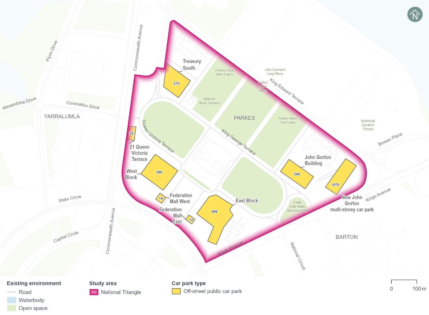
There are several existing off-street public car parks located within the National Triangle precinct which accommodate around 1,400 car parking spaces as shown in Figure 14-6 and listed below:
- Treasury South car park: at-grade car park with 270 spaces
- 21 Queen Victoria Terrace car park: at-grade car park with around 32 spaces
- John Gorton Building car park: at-grade car park with around 288 spaces
- West Block car park: at-grade car park with around 369 spaces
- East Block car park: at-grade car park with around 409 spaces
- Federation Mall car park: at-grade car parks with around 28 spaces.
Aerial imagery indicates that the Treasury South, John Gorton Building, and East Block car parks experience high parking demand on weekdays. At the same time, there is typically some spare capacity in the West Block car park.
In addition to the above, the new John Gorton multi-storey car park is currently under construction. This car park replaces the previous 500 space capacity car park in the same location, with the new car park providing a net increase of an additional 570 car parking spaces.
Property access
There are no direct property accesses along the Project's alignment within the National Triangle precinct. However, car and coach parking associated with Old Parliament House, and other nearby landmarks and cultural institutions is provided along Parliament Square, which connects to King George Terrace along the Project's alignment. It is noted that Parliament Square also has connections to Queen Victoria Terrace to the south of Old Parliament House.
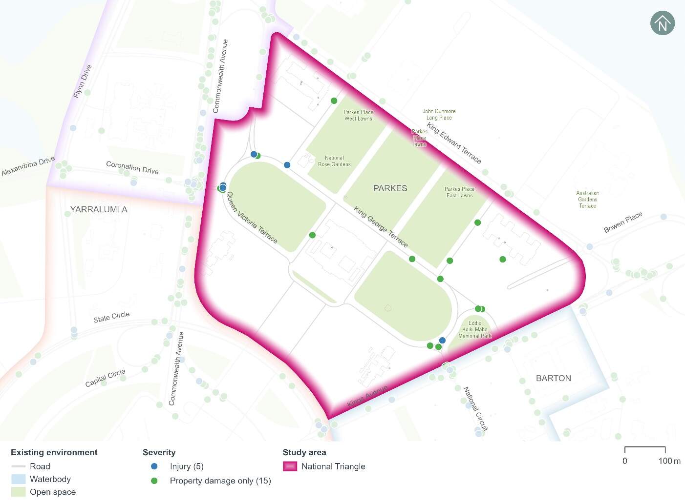
Crash history
The five year crash history (1 January 2018 to 31 December 2022) within the National Triangle precinct can be seen in Figure 14-7. A total of 20 crashes have been recorded during the five year period, including:
- Five crashes that resulted in a minor injury (around 25%)
- 15 crashes that resulted in property damage only (around 75%).
The following common crash types occurred:
- Around 25% of crashes involved a rear end collision
- Around 20% of crashes involved a same direction side swipe.
One of the crashes involved a pedestrian.
Modelling approach
The transport modelling assumptions have adopted the 'committed and funded expenditure approach' as per Infrastructure Australia guidance. This approach was agreed in consultation with Treasury and other key stakeholders including TCCS. The 'committed and funded expenditure approach' requires that only transport projects identified as 'committed and funded' are to be included in the 2031 and 2041 with and without Project scenarios.
As identified in the ACT Infrastructure Plan update - Transport (ACT Government, 2024), project priorities identified beyond the current budget are indicative and may change in response to community preferences, shifts in demand for services and the availability of funding. This means that any projects that might be in planning or may be required to accommodate expected travel demands but have not been identified as 'committed and funded' are not included in the traffic modelling for the Project. This is particularly prevalent in the 2041 scenarios during Project operation.
Based on the transport modelling inputs and assumptions presented above, the transport modelling assesses the impacts of the Project in isolation. It does not consider the broader network benefits that may be realised by the implementation of planned (but not committed and funded) transport infrastructure projects.
By not considering other changes to the transport network, the transport modelling presents an absolute worst-case scenario in relation to the performance of the future road network.
14.2.2 Potential impacts - construction
Potential impacts of the construction of the Project on parking and access within the precinct are summarised in the following sections. Other construction-related impacts have been assessed at a Project-wide basis, where relevant, in Section 11.1.2 of Chapter 11 (Project-wide issues).
Kerbside uses
State Circle East alignment option
It is estimated that up to eight on-street kerbside spaces along the 21 Queen Victoria Terrace access road (off-alignment) would be temporarily lost to support the construction work areas required for the State Circle East alignment option. This represents around 3% of the total 274 on-street kerbside spaces identified within the National Triangle precinct. However, construction works are likely to be staged, so the temporary loss of on-street kerbside spaces across the precinct may be less at any given time during the construction program.
National Triangle-Barton alignment option
It is estimated that up to 129 on-street kerbside spaces and five bus zones would be removed to support the National Triangle-Barton alignment option in the National Triangle precinct, including:
- 18 spaces and three bus zones on King George Terrace (on-alignment)
- Four spaces on Langton Crescent (off-alignment)
- Six spaces on Parkes Place West (off-alignment)
- Six spaces on Parkes Place East (off-alignment)
- 93 spaces and two bus zones on Parliament Square (off-alignment)
- Two spaces on Queen Victoria Terrace (off-alignment).
This represents around 47% of the total 274 on-street kerbside spaces identified within the National Triangle precinct. Of these kerbside uses, 30 on-street kerbside spaces and three bus zones would be permanently lost as part of the Project's permanent works for the National Triangle-Barton alignment option. The remaining spaces would be temporarily lost during construction. However, construction works are likely to be staged, so the temporary loss of on-street kerbside spaces across the precinct may be less at any given time during the construction program. Any potential temporary relocation of the bus zones associated with Old Parliament House during construction of the Project would be investigated further as part of detailed construction planning.
There are several off-street public car parks located throughout the National Triangle precinct which may be able to cater for some of the parking demand associated with the displaced kerbside uses. Any accessible spaces impacted by the works would be relocated temporarily as close as possible to their existing location.
Off-street parking
Construction compound D would result in the temporary loss of all 32 off-street spaces within the 21 Queen Victoria Terrace car park.
Local area access
State Circle East alignment option
Construction of the State Circle East alignment option would result in local traffic reassignment (when traffic is redistributed as drivers choose alternative routes due to changes in the road network) to Kings Avenue. To manage traffic congestion and maintain reasonable vehicle travel times along Kings Avenue, the right turn from King George Terrace to Kings Avenue would be temporarily restricted during construction of the State Circle East alignment option.
Vehicles that currently make this turn would need to use available alternative routes such as turning right onto Kings Avenue via Queen Victoria Terrace, or adjust their trip further afield to use the broader arterial road network.
The required local area access diversions would likely result in a slight increase in travel time for impacted motorists.
Mitigation measures TT3 and TT6 in Chapter 21 (Environmental management and mitigation measures) would address local area access impacts.
National Triangle-Barton alignment option
Construction of the National Triangle-Barton alignment option would require closure of King George Terrace to vehicles from Langton Crescent to Kings Avenue during the construction program. The sections of King George Terrace between Parkes Place West and Parkes Place East, and between Walpole Crescent and Kings Avenue would be closed permanently to vehicles once construction is complete.
Vehicles would need to use alternate routes such as Queen Victoria Terrace or King Edward Terrace. The Parkes Place West and Parkes Place East intersections with King George Terrace would generally remain open, except during construction of the track crossings at these intersections, which would be subject to weekend closures.
The southern end of Langton Crescent and its intersection with King George Terrace would be closed to traffic. This connection would be removed as part of the Project's permanent works for the National Triangle-Barton alignment option, resulting in a permanent change to local area access arrangements at this location. Vehicles would need to use alternative routes such as Newlands Street and Parkes Place West, or the northern end of Langton Crescent to connect with King Edward Terrace.
The required local area access diversions would likely result in a slight increase in travel time for impacted motorists.
Mitigation measures TT3 and TT6 in Chapter 21 (Environmental management and mitigation measures) would address local area access impacts.
Property access
State Circle East alignment option
Construction of the State Circle East alignment option would not change any property accesses within the National Triangle precinct.
National Triangle-Barton alignment option
The existing property accesses to Parliament Square and Old Parliament House on King George Terrace would not be accessible by vehicles from commencement of construction, and permanently due to the closure of King George Terrace for the National Triangle-Barton alignment option. However, the alternative accesses to Parliament Square and Old Parliament House on Queen Victoria Terrace would be maintained throughout construction. Accessing Parliament Square and Old Parliament House from Queen Victoria Terrace instead of King George Terrace could result in a slight increase in travel time depending on where drivers are travelling from and how far afield they adjust their travel route.
14.2.3 Potential impacts - operation
Potential operational impacts on the road network, active travel and parking of relevance to the precinct are summarised in the following sections. Other operational impacts have been assessed at a Project-wide basis, where relevant, in Section 11.2.2 of Chapter 11 (Project-wide issues).
Road network changes
The road network changes within the National Triangle precinct to accommodate the Project would include road closures to vehicles, speed limit adjustments, adjustments to existing lanes, adjustments to intersections, and adjustments to access arrangements. Refer to Chapter 5 (Project description) for further discussion on road network changes.
Traffic volumes and patterns
Traffic volumes and patterns have been modelled to compare weekday peak hour changes in traffic flow across the National Triangle precinct, particularly on Queen Victoria Terrace, Langton Crescent, and King George Terrace.
2031 and 2041 were adopted as the future years for the traffic modelling. The years 2031 and 2041 were used to represent indicative future scenarios, providing a benchmark for assessing the potential operational impacts of the Project.
Traffic volume changes are summarised in Table 14-3 and Table 14-4. These traffic flow changes are due to the following:
- Regional and local traffic reassignment (when traffic is redistributed as drivers choose alternative routes due to changes in the road network) caused by the Project's road network changes and consequent impacts to road network performance
- Changes in mode choice due to the introduction of light rail.
Adjacent to the National Triangle precinct, traffic volumes along King Edward Terrace would also increase during the AM and PM peak hours as a result of the Project's road network changes and resulting traffic reassignment.
| Road | Location | Direction | 2031 scenario | 2041 scenario | ||||||
|---|---|---|---|---|---|---|---|---|---|---|
| Without Project | With Project | Difference | Without Project | With Project | Difference | |||||
|
King George Terrace |
Between Parliament Square East and Parliament Square West |
Eastbound |
410 |
0 |
-410 |
-100% |
420 |
0 |
-420 |
-100% |
|
Westbound |
350 |
0 |
-350 |
-100% |
230 |
0 |
-230 |
-100% |
||
|
Queen Victoria Terrace |
Between Parliament Square East and Parliament Square West |
Eastbound |
300 |
460 |
160 |
53% |
260 |
510 |
250 |
96% |
|
Westbound |
170 |
260 |
90 |
53% |
180 |
260 |
80 |
44% |
||
| Road | Location | Direction | 2031 scenario | 2041 scenario | ||||||
|---|---|---|---|---|---|---|---|---|---|---|
| Without Project | With Project | Difference | Without Project | With Project | Difference | |||||
|
King George Terrace |
Between Parliament Square East and Parliament Square West |
Eastbound |
260 |
0 |
-260 |
-100% |
180 |
0 |
-180 |
-100% |
|
Westbound |
170 |
0 |
-170 |
-100% |
200 |
0 |
-200 |
-100% |
||
|
Queen Victoria Terrace |
Between Parliament Square East and Parliament Square West |
Eastbound |
40 |
220 |
180 |
450% |
120 |
190 |
70 |
58% |
|
Westbound |
360 |
470 |
110 |
31% |
310 |
410 |
100 |
32% |
||
Road network performance
Within the National Triangle precinct, there would be localised areas where higher congestion levels would occur in both the with and without Project scenarios in the AM and PM peak hours in both 2031 and 2041, such as on the approaches to intersections.
Changes to the road network due to the Project, including traffic signal operation changes contribute to congestion and vehicle delay when compared to the without Project scenario in the 2031 scenario:
- Increased congestion and delay on Queen Victoria Terrace on approach to Kings Avenue during the AM and PM peak hour and reduced congestion and delay on Queen Victoria Terrace on approach to Langton Crescent and Commonwealth Avenue during the AM and PM peak hours
- Increased congestion and delay on Parkes Place West on approach to King Edward Terrace during the AM peak hour
- Reduced congestion and delay on Langton Crescent on approach to Commonwealth Avenue during the PM peak hour.
Similar changes to network congestion and vehicle delays would occur during the AM and PM peak hours in the 2041 scenario.
Intersection performance
The performance of the key intersections within the National Triangle precinct with and without the Project for the National Triangle-Barton alignment option is provided in Table 14-5 and Table 14-6. Intersection performance is evaluated using the level of service and average delay assessed for each intersection. Level of service represents the extent of delays experienced by drivers at an intersection. Further detail on intersection performance can be found in Technical Report 1 - Traffic and transport. Key findings relating to intersection performance are as follows:
AM peak hour:
- The King George Terrace/Parkes Place West and King George Terrace/Parkes Place East intersections would operate satisfactorily at a level of service C with the Project in 2031 and 2041 scenarios
- The performance of the King George Terrace/Parkes Place West intersection would be better with the Project compared to without the Project, primarily due to the closure of King George Terrace to vehicles between Parkes Place East and West, which results in much lower traffic volumes at this intersection particularly in the 2041 scenario
- The Walpole Crescent/Queen Victoria Terrace intersection would operate at a level of service F with and without the Project in 2031 and 2041 scenarios. This is a constraint of the existing configuration and limited offset from the Kings Avenue/Queen Victoria Terrace intersection, which would result in high delays, particularly to vehicles on Queen Victoria Terrace when queues extend back from the Kings Avenue intersection.
PM peak hour:
- The King George Terrace/Parkes Place West and King George Terrace/Parkes Place East intersections would operate satisfactorily at a level of service C with the Project in 2031 and 2041 scenarios
- Similar to the AM peak hour, the performance of the King George Terrace/Parkes Place West intersection would be better with the Project compared to without the Project in 2031 and 2041 scenarios, primarily due to the closure of King George Terrace to vehicles between Parkes Place East and West which results in much lower traffic volumes at this intersection
- The Walpole Crescent/Queen Victoria Terrace intersection would reduce from a level of service A without the Project to a level of service F with the Project in the 2031 scenario. This is due to a combination of the closure of access to the National Triangle precinct for vehicles from the King George Terrace/Kings Avenue intersection, as well as the closure of King George Terrace to vehicles between Parkes Place East and West. These closures result in higher traffic volumes with the Project at the Walpole Crescent/Queen Victoria Terrace intersection. The limited offset from the Kings Avenue/Queen Victoria Terrace intersection results in high delays for vehicles on Queen Victoria Terrace when queues extend back from the Kings Avenue intersection.
- The Walpole Crescent/Queen Victoria Terrace intersection would operate at a level of service F with and without the Project in the 2041 scenario.
| Intersection | 2031 scenario | 2041 scenario | ||||||
|---|---|---|---|---|---|---|---|---|
| Without Project | With Project | Without Project | With Project | |||||
|
Average delay (seconds) |
Level of service |
Average delay (seconds) |
Level of service |
Average delay (seconds) |
Level of service |
Average delay (seconds) |
Level of service |
|
|
King George Terrace/Parkes Place West |
6 |
A |
24 |
C |
46 |
D |
25 |
C |
|
King George Terrace/Parkes Place East |
7 |
A |
24 |
C |
7 |
A |
26 |
C |
|
Walpole Crescent/Queen Victoria Terrace |
>150 |
F |
>150 |
F |
>150 |
F |
>150 |
F |
| Intersection | 2031 scenario | 2041 scenario | ||||||
|---|---|---|---|---|---|---|---|---|
| Without Project | With Project | Without Project | With Project | |||||
|
Average delay (seconds) |
Level of service |
Average delay (seconds) |
Level of service |
Average delay (seconds) |
Level of service |
Average delay (seconds) |
Level of service |
|
|
King George Terrace/Parkes Place West |
>150 |
F |
37 |
D |
>150 |
F |
27 |
C |
|
King George Terrace/Parkes Place East |
13 |
B |
23 |
C |
3 |
A |
23 |
C |
|
Walpole Crescent/ Queen Victoria Terrace |
6 |
A |
>150 |
F |
122 |
F |
>150 |
F |
Active travel
The key pedestrian and cyclist provisions that would be provided within the National Triangle precinct as part of the Project for the National Triangle-Barton alignment option and their benefits or impacts are summarised in Table 14-7.
| Proposed treatment | Impact or benefit |
|---|---|
|
A new raised intersection would be provided at the following locations:
|
The raised intersection treatments would promote safer crossing for pedestrians and cyclists by reducing vehicle speeds. |
|
A shared path would be provided on the northern side of the alignment between Commonwealth Avenue and Parkes Place West running parallel to the Treasury Stop. |
The shared path would accommodate pedestrian and cyclist access between Commonwealth Avenue and the Treasury Stop. |
|
Pedestrian footpaths would be augmented in the vicinity of the Treasury Stop and between Parkes Place East and Kings Avenue to facilitate the road closure. |
The road closure would remove potential conflicts between vehicles and pedestrians/cyclists improving safety and accessibility. |
Kerbside uses
The National Triangle-Barton alignment option would remove around 30 on-street kerbside spaces within the National Triangle precinct, including:
- 18 spaces on King George Terrace (on-alignment)
- Six spaces on Parkes Place West (off-alignment)
- Six spaces on Parkes Place East (off-alignment).
The loss of around 30 on-street kerbside spaces represents 11% of the total on-street parking supply within the National Triangle precinct. If the Old Parliament House bus zones on King George Terrace are relocated, additional kerbside spaces may be removed elsewhere near Old Parliament House. The potential relocation of these bus zones would be investigated further as part of ongoing design development.
Historical aerial imagery as well as site observations in June 2024 indicate the spaces along King George Terrace outside Old Parliament House are generally well utilised on weekdays, however generally have spare capacity on weekends. On-street parking demand is typically much lower on adjacent side roads on both weekdays and weekends, including Parkes Place East and West.
Off-street parking
The Project would not change any off-street parking within the National Triangle precinct.
Local area access
The National Triangle-Barton alignment option would change the following local area access arrangements within the National Triangle precinct:
- The southern end of Langton Crescent connecting into King George Terrace would be closed to traffic
- King George Terrace between Parkes Place West and Parkes Place East would be closed to traffic in both directions
- King George Terrace from Walpole Crescent to Kings Avenue would be closed to traffic in both directions.
Vehicles that currently travel between King George Terrace and Langton Crescent would need to travel via Parkes Place West and Newlands Road instead, or alternatively change their trip further afield and approach/depart via the northern end of Langton Crescent.
Vehicles that currently travel along King George Terrace between Parkes Place West and Parkes Place East would need to travel on alternate roads, including King Edward Terrace or Queen Victoria Terrace.
Lastly, vehicles that currently enter or exit the National Triangle precinct via the Kings Avenue/King George Terrace intersection would need to use the Kings Avenue/Walpole Crescent intersection.
These changes to local area access would likely result in a slight increase in travel time for impacted motorists depending on where drivers are travelling to/from and how far afield they adjust their travel route.
Property access
The existing vehicle property accesses to Parliament Square and Old Parliament House on King George Terrace would be removed in the National Triangle-Barton alignment option. All vehicle access to Parliament Square and Old Parliament House would be via the existing accesses on Queen Victoria Terrace. Accessing Parliament Square and Old Parliament House from Queen Victoria Terrace instead of King George Terrace could result in a slight increase in travel time depending on where drivers are travelling from and how far afield they adjust their travel route.
14.2.4 Precinct specific management and mitigation measures
Environmental management for this Project is detailed in Part C (Mitigation and residual environmental risks). This includes construction and operational mitigation measures (where relevant) in Chapter 21 (Environmental management and mitigation measures) that are applicable to the Project as a whole.
No further precinct-specific measures have been identified for traffic and transport impacts at the National Triangle precinct.
14.3 Noise and vibration
This section provides an assessment of the potential noise and vibration impacts associated with the construction and operation of the Project within the National Triangle precinct. Further detail on the noise and vibration impact assessment is provided in Technical Report 9 - Noise and vibration. The methodology applied for this assessment is summarised in Chapter 10 (Assessment methodologies) and discussed in detail in Section 4 of Technical Report 9 - Noise and vibration.
14.3.1 Existing environment
Sensitive receivers and noise catchment area
Noise Catchment Areas were determined based on the general ambient noise environment of the area, and the types of receivers and land uses potentially affected by the Project. Noise Catchment Area 2 was identified for the noise assessment of the National Triangle precinct. Noise Catchment Area 2 and associated sensitive receivers are shown in Figure 14-8.
Land uses within Noise Catchment Area 2 are predominantly passive and active recreation, commercial and public building land uses.
No residential receivers are located in the National Triangle precinct, however Noise Catchment Area 2 extends north past Lake Burley Griffin into the residential suburb of Campbell.
Heritage-listed items within the Noise Catchment Area include the National Library of Australia and surrounds (listed on the Commonwealth Heritage List), Treasury Building (nominated for the Commonwealth Heritage List), Old Parliament House and Curtilage (listed on the Commonwealth Heritage List) and the John Gorton Building (listed on the Commonwealth Heritage List). The Parliament House Vista (listed on the Commonwealth Heritage List) is also located within this Noise Catchment Area. Further detail on heritage items is included in Section 14.5.
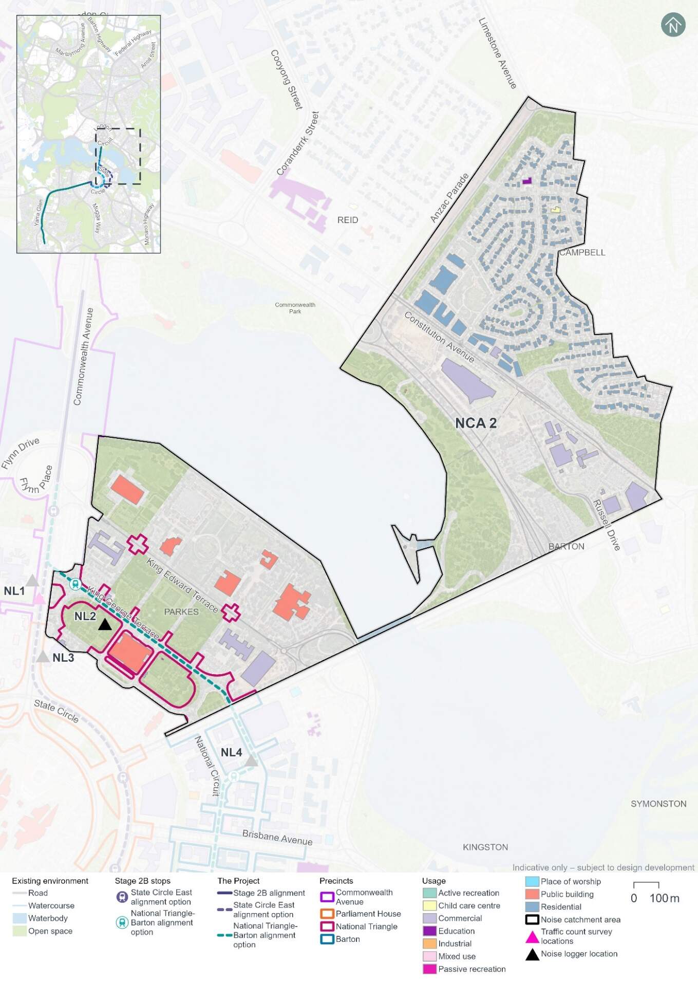
Existing noise levels
Unattended noise monitoring was carried out at one location in the National Triangle precinct (at noise logger 2 (NL2)) between 2 and 15 May 2024, to provide a representation of existing background noise levels. The results of this monitoring are summarised in Table 14-8. The LA90 level is the noise level exceeded for 90% of the sample period, and the LAeq level is the energy averaged noise level over the 15-minute period.
| Location ID | Noise logger address | Rating background level (LA90), dB(A)1 | Ambient noise level (LAeq), dB(A)1 | ||
|---|---|---|---|---|---|
|
Day2 |
Night2 |
Day2 |
Night2 |
||
|
NL2 |
The Broinowski Rose Garden, Parliament Square and King George Terrace, Parkes |
44 |
30 |
55 |
41 |
Notes:
- dB(A) represents A-weighted decibels, the relative frequency response used in sound measuring instruments.
- In accordance with the NSW Noise Policy for Industry (NSW Environment Protection Authority, 2017) time of day is defined as follows:
- Day - the period from 7 am to 6 pm Monday to Saturday or 8 am to 6 pm on Sundays and public holidays.
- Night - 10 pm to 7 am (Monday to Saturday); 10 pm to 8 am (Sundays and public holidays)
- Evening (not included in table) - the period from 6 pm to 10 pm.
Attended noise measurements were also carried out at each unattended monitoring location on 1 May 2024 during the daytime period. The results of this monitoring are summarised in Table 14-9.
| Location ID | LAeq dB(A) | LA90 dB(A) | Comments |
|---|---|---|---|
|
NL2 |
53 |
44 |
Audible noises included distant traffic, reversing alarms, bird noises and distant construction. Reversing alarms were the most dominant noise source. |
14.3.2 Potential impacts - construction
The following sections present construction noise and vibration assessment results without the application of mitigation measures (referred to as unmitigated). Measures in Chapter 21 (Environmental management and mitigation measures) and Appendix L (Environmental Management Plan outline) would be implemented to manage these potential impacts. With the application of these mitigation measures it is expected that the unmitigated impacts would be noticeably reduced or, in some cases, avoided altogether.
Construction noise
Approach
In accordance with Section 29 and Item 16 of Schedule 2 Table 2.3 of the ACT Environment Protection Regulation 2005, construction of light rail or major roads do not require noise to be assessed against specific numerical noise limits as they are not taken to cause environmental harm. Item 16 of Table 2.3 places no conditions on the “Noise emitted in the course of constructing or maintaining a major road, a dedicated bus way, a railway or light rail.” Section 9.11 of the Environment Protection (Noise) Environment Protection Policy 2010 provides the following reasoning for the exemption of roadworks, noting that “the construction and maintenance of roads is central to the economic and social well-being of the community.”
In the absence of Territory specific quantifiable criteria, the NSW Interim Construction Noise Guideline (NSW Department of Environment and Climate Change, 2009) has been used to guide this assessment, as the Project would be of a large scale and occur within a relatively close proximity to noise sensitive receivers.
While construction noise generated by the Project is not required to be assessed against specific numerical noise limits, the derived assessment levels used in this EIS provide an indication of potential noise impacts to assist in the identification of appropriate mitigation measures, and were based on the NSW Interim Construction Noise Guideline (NSW Department of Environment and Climate Change, 2009).
The construction noise assessment presents a worst-case assessment which adopts conservative assumptions. For example, the noise model has used the shortest separation distance between worksites and each sensitive receiver, and has assumed the noisiest equipment would be in use. Actual construction noise levels experienced by receivers would generally be lower than the construction noise predictions. Modelling assumptions are discussed further in Technical Report 9 - Noise and vibration.
Scenarios
The noise assessment considers noise impacts from concurrent construction work across multiple precincts, but the results are reported at a precinct level. Receivers in Noise Catchment Area 2 (refer to Figure 14-8) have the potential to experience impacts from the construction of either alignment option, which could be generated from works within multiple precincts. Where relevant, construction scenarios have been assessed separately for each alignment option to reflect the different locations of proposed work.
The following construction scenarios have been modelled as a part of the noise and vibration impact assessment for the National Triangle precinct:
- Mobilisation and establishment of construction compound sites
- Protection, relocation, treatment and/or decommissioning of utilities
- Earthworks, road works and construction of light rail infrastructure (which includes construction of the covered section between Commonwealth Avenue and State Circle for the State Circle East alignment option using equipment such as hammers and excavators)
- Construction of stops
- Construction of Commonwealth Avenue light rail bridges
- Construction of bridges on land.
Finishing works, including rectification of any defects, would be carried out progressively during construction and have been considered in the assessment of each scenario described above. Testing and commissioning works are not expected to entail any additional noise and vibration impact beyond the standard operation of the Project, therefore a quantitative assessment has not been undertaken.
Construction activities for the Project would be undertaken between the hours of 7am and 6pm Monday to Saturday (standard construction hours), as far as practicable. As outlined in Section 6.5 of Chapter 6 (Construction), some work would likely be required outside of standard construction hours to minimise disruptions to traffic, minimise disturbance to surrounding landowners and businesses, and/or maintain safe and efficient operation of key roads and public transport facilities. Work proposed outside of standard construction hours would require assessment and approval on a case-by-case basis, as outlined in mitigation measure NV3 in Chapter 21 (Environmental management and mitigation measures).All construction scenarios have been assessed based on work occurring during standard construction hours and during out of standard hours periods, with the exception of mobilisation and establishment of construction compound sites, which was only assessed as occurring during standard construction hours.
Construction noise scenarios have been categorised into 'peak' and 'typical' works to represent the likely range of potential noise impacts. 'Peak' works represent the noisiest works which require the use of noise intensive equipment such as concrete saws and rock breakers, while 'typical' works represent typical noise emissions from a construction scenario when noise intensive equipment is not in use. Consequently, the 'typical' scenarios would result in a reduced number of noise affected receivers compared to 'peak' scenarios. Where possible, peak works and other high noise generating works would be carried out during standard construction hours. Should high noise impact activities be required to be undertaken outside of standard construction hours, they would be subject to specific controls identified in mitigation measures NV3 and NV4 (refer to Chapter 21 (Environmental management and mitigation measures)).
Assessment results
During standard construction hours and out of hours, no residential receivers within the Noise Catchment Area assessed for the National Triangle precinct are expected to be moderately noise affected or highly noise affected due to any of the construction scenarios.
The number of non-residential buildings predicted to be moderately noise affected is shown in Table 14-10, which assumes no mitigation measures are in place. The assessment results are relevant to both alignment options except where otherwise indicated, for example, for the 'earthworks, road works, and construction of light rail infrastructure' scenarios.
Construction noise modelling has been completed assuming the noisiest equipment would be in use on the boundary of the Project area footprint, allowing for a worst-case scenario to be assessed. Section 3.2 of Technical Paper 9 - Noise and vibration provides further detail on the assessment approach.
| Construction scenario1 | Building/area usage | Number of non-residential noise sensitive buildings assessed to be moderately noise affected2,3 (unmitigated) |
|---|---|---|
|
Noise Catchment Area 2 |
||
|
Protection, relocation, treatment and/or decommissioning of utilities - peak |
Active recreation |
2 |
|
Passive recreation |
1 |
|
|
Public buildings |
4 |
|
|
Protection, relocation, treatment and/or decommissioning of utilities - typical |
Public buildings |
1 |
|
Earthworks, road works, and construction of light rail infrastructure - peak (State Circle East alignment option) |
Public buildings |
1 |
|
Earthworks, road works, and construction of light rail infrastructure - typical (State Circle East alignment option) |
Public buildings |
1 |
|
Earthworks, road works, and construction of light rail infrastructure - peak (National Triangle-Barton alignment option) |
Active recreation |
2 |
|
Passive recreation |
1 |
|
|
Public buildings |
4 |
|
|
Earthworks, road works, and construction of light rail infrastructure - typical (National Triangle-Barton alignment option) |
Active recreation |
2 |
|
Passive recreation |
1 |
|
|
Public buildings |
4 |
|
|
Construction of Commonwealth Avenue light rail bridges - peak |
Public buildings |
1 |
|
Construction of bridges on land - peak |
Public buildings |
1 |
Notes:
- Where a construction scenario did not result in any non-residential buildings being moderately noise affected, it has not been included in this table.
- Buildings have been assessed when in use, which is assumed to be the daytime period for most buildings, except hotels which have been assessed for day and night-time periods.
- The noise levels in this assessment represent predicted noise levels at each building façade. Individual buildings have each been assessed as a single receiver, including where they are located at the same address or are part of the same facility. At multistorey buildings, the construction noise assessment documents noise levels for the most affected floor.
The findings of the unmitigated peak and typical construction noise impact assessments for the National Triangle precinct during the daytime indicate:
- The 'peak' protection, relocation, treatment and/or decommissioning treatment of utilities, and 'peak' and 'typical' earthworks, road works and construction of light rail infrastructure scenarios (for the National Triangle-Barton alignment) are predicted to result five non-residential buildings being moderately noise affected, including the Tennis Canberra tennis courts, National Portrait Gallery, Old Parliament House, and receiver buildings within the Old Parliament House Gardens
- The 'peak' and 'typical' earthworks, road works and construction of light rail infrastructure scenarios for the State Circle East alignment option are predicted to result in one non-residential building - the National Library of Australia - being moderately noise affected
- The Aboriginal Tent Embassy is considered as a mixed-use building and would likely be moderately noise affected due to its location near the Old Parliament House and Gardens.
Sleep awakening assessment
A sleep awakening assessment has been carried out using the 'typical' works case for each scenario, except for the mobilisation and establishment of construction compound sites (which has been assessed for standard construction hours only, and therefore not included in the assessment). The 'typical' works case has been used as it is assumed that noise intensive equipment (for example concrete saws and rock breakers) used for peak works would not be used during the night. The assessment approach is described further in Section 3.2 of Technical Report 9 - Noise and vibration.
The assessment for this precinct indicates that the awakening reaction level is not predicted to be exceeded at any residential receiver.
Construction vibration
Vibration intensive work has the potential to cause human discomfort or cosmetic damage to buildings and structures, if not appropriately managed. Key potential sources of vibration from the proposed construction activities would include vibratory rollers, vibratory piling rigs, and excavators with hydraulic hammer attachments.
Table 4-3 of Technical Report 9 - Noise and vibration presents the minimum working distances to be maintained between vibration intensive work to avoid cosmetic damage or human discomfort. Appendix E of Technical Report 9 - Noise and vibration provides mapping of the minimum working distances for a large hydraulic hammer (which has been selected to represent one of the most vibration intensive pieces of equipment proposed to be used) for human response and cosmetic damage.
Human comfort
Potential exceedances of human comfort vibration criteria have been assessed for residential buildings. No residential buildings are located within the human response minimum working distance for a large hydraulic hammer (within 73 m of the Project area boundary), and therefore exceedances of human response criteria are not predicted.
Cosmetic damage
One light-framed structure - The Lawns of the Lobby - is located within the minimum working distance for a large hydraulic hammer (22 m for light-framed structures) for cosmetic damage. Several heritage-listed structures are located within the minimum working distance for a large hydraulic hammer (60 m for heritage and other sensitive structures) for cosmetic damage.
Heritage structures that may potentially be affected by vibration from large hydraulic hammers and other proposed vibratory plant are listed in Table 14-11. Potential impacts to heritage are discussed further in Section 14.5.
| Heritage place name | Distance between Project area and heritage structures (m) |
|---|---|
|
Treasury Building (nominated for the Commonwealth Heritage List) |
14 |
|
Old Parliament House and Curtilage (listed on the Commonwealth Heritage List) |
1 |
|
John Gorton Building (listed on the Commonwealth Heritage List) |
28 |
|
King George V Memorial (listed on the Commonwealth Heritage List) |
0 |
|
Old Parliament House Gardens (listed on the Commonwealth Heritage List) |
0 |
|
National Rose Gardens (listed on the Commonwealth Heritage List) |
0 |
|
Aboriginal Tent Embassy (listed on the Commonwealth Heritage List as a part of the Parliament House Vista) |
49 |
|
Communications Centre (at John Gorton Building) (listed on the Commonwealth Heritage List) |
40 |
This presents a worst-case unmitigated assessment which has assumed that vibration-intensive equipment could be used at the boundary of the Project area. In reality, vibration intensive equipment is not likely to be used throughout the entire Project area. Instead, this equipment would typically be limited to areas of the footprint away from the boundary of the Project area, where it could be used to construct the light rail alignment, for example, in road medians and verges.
Where the use of vibration intensive equipment within the relevant minimum working distances cannot be avoided, detailed inspection, vibration monitoring and consultation with the sensitive receivers would be undertaken. Further detail on the approach to managing potential vibration impacts is included in mitigation measure NV6 in Chapter 21 (Environmental management and mitigation measures).
Construction road traffic noise
Construction traffic associated with construction compounds would be distributed across the road network with King Edward Terrace serving as a key route for construction traffic in this precinct. Section 6.7.1 of Chapter 6 (Construction) describes proposed heavy vehicle haulage routes. Heavy vehicle movements, which are likely to have the largest noise and vibration impact, would generally be for deliveries of construction plant, supplies and infrastructure, and to transport soil and waste materials.
A summary of the forecast 2031 traffic volumes without the Project, the additional traffic contributed by construction of the Project, and the resultant relative change in noise levels during the daytime (AM peak period, 8am to 9am) and night-time (10pm to 7am) are presented in Table 14-12. The year 2031 was selected as representative of the peak year of construction.
The majority of haulage routes would receive relative noise level increases of less than 2 dB(A). Changes in noise levels of up to 2 dB(A) are not considered to be perceptible by the average listener.
Increases in road traffic noise greater than 2 dB(A) has been identified along the proposed haulage route on Walpole Crescent between King George Terrace and Queen Victoria Terrace in the night-time period. However, the proposed haulage route on Walpole Crescent adjoins recreational areas only. Therefore, the increases of 8.7 dB(A) and 2.8 dB(A) in the northbound and southbound direction respectively are not predicted to negatively impact any noise sensitive receivers during the night-time period.
| Route | Direction | Existing traffic (average hourly) | Additional construction traffic (peak hourly) | Relative increase, dB(A) | ||
|---|---|---|---|---|---|---|
| Light | Heavy | Light1 | Heavy1 | |||
|
Daytime assessment |
||||||
|
King Edward Terrace between Bowen Place and Parkes Place |
Westbound |
211 |
16 |
2 |
2 |
0.2 |
|
Eastbound |
436 |
33 |
2 |
2 |
0.1 |
|
|
Walpole Crescent between King George Terrace and Queen Victoria Terrace |
Northbound |
103 |
8 |
2 |
2 |
0.5 |
|
Southbound |
98 |
7 |
2 |
2 |
0.5 |
|
|
Night-time assessment |
||||||
|
King Edward Terrace between Bowen Place and Parkes Place |
Westbound |
23 |
2 |
10 |
1 |
1.7 |
|
Eastbound |
40 |
3 |
10 |
1 |
1.1 |
|
|
Walpole Crescent between King George Terrace and Queen Victoria Terrace |
Northbound |
2 |
0 |
10 |
1 |
8.7 |
|
Southbound |
12 |
1 |
10 |
1 |
2.8 |
|
Notes:
- Peak hourly volumes for additional construction light vehicles have been determined by first combining estimated volumes for construction activities and workforce and then halving for each direction. Peak hourly volumes for additional construction heavy vehicles have also been halved for each direction.
14.3.3 Potential impacts - operation
Operational rail noise and vibration
The following sections provide a summary of potential operational rail noise and vibration impacts in the National Triangle precinct. Only the National Triangle-Barton alignment travels through the National Triangle precinct, and therefore the noise and vibration sensitive buildings in the precinct are only expected to be potentially impacted by the National Triangle-Barton alignment option.
Exceedances of operational rail noise trigger levels are not anticipated to result from the State Circle East alignment in this precinct.
Airborne rail noise assessment
Operational rail noise levels were predicted at each of the receivers within 300 m of the alignment. This involved assessment of noise levels at a total of nine receivers in the National Triangle precinct, including public buildings, active recreation receivers and passive recreation receivers, assuming no mitigation measures are in place. Operational rail noise was modelled based on indicative LRV design speeds identified along the alignment during the design development process.
The results of the operational rail noise assessment indicated compliance with both daytime and night-time airborne noise trigger levels. No exceedances of the trigger levels were predicted. Rail noise would be intermittent and last for a relatively short duration as the LRV passes the receiver, and would not represent a constant noise source.
Operational rail noise contours for the Project are presented in Appendix F of Technical Report 9 - Noise and vibration.
Ground-borne rail noise assessment
There are no residential receivers located in proximity to the alignment that have the potential to be impacted by any ground-borne noise. The nearest sensitive receiver is a commercial building use, which does not have ground-borne noise criteria. The Aboriginal Tent Embassy is not predicted to exceed the noise trigger levels at the sovereignty sign, ceremonial fire or demountable. Noise levels throughout the area within the Aboriginal Tent Embassy where temporary structures, such as tents, are usually located are also not predicted to exceed the noise trigger levels.
No sensitive receivers are expected to experience ground-borne noise levels over the trigger levels.
Rail vibration assessment
The predicted vibration levels for the National Triangle precinct at the most affected (closest) receiver are presented in Table 14-13. No sensitive receivers are expected to experience vibration dose value over the nominated human comfort criteria.
| Address and building use | Distance from track centreline, m | Vibration Criteria (Daytime), m/s1.75 | Predicted equivalent vibration dose value (Daytime), m/s1.75 | Vibration Criteria (Night), m/s1.75 | Predicted equivalent vibration dose value (Night), m/s1.75 |
|---|---|---|---|---|---|
|
Old Parliament House (19 King George Terrace, Parkes) Commercial |
21 |
0.4 |
0.009 |
0.4 |
0.005 |
Heritage items in the National Triangle precinct are not predicted to be adversely impacted by rail vibration. Further information on heritage listed items is provided in Section 14.5.
Road traffic noise assessment
The assessment of road traffic noise has been completed in accordance with the Noise Management Guideline (Roads ACT, 2018). The road traffic noise criteria applicable to upgrading roads in existing areas is provided in Table 14-14.
| Existing traffic noise level at adjacent buildings, LAeq,15hr | Traffic noise level at adjacent buildings after road works completed |
|---|---|
|
> 60 dB(A) |
Equal to existing level (not greater than 65 dB(A)) |
|
55 - 60 dB(A) |
60 dB(A) |
|
< 55 dB(A) |
Not more than 5 dB(A) above existing level |
To assess the potential impact of the Project on noise sensitive buildings, relative increases in future road traffic noise levels have been predicted for the 'without Project' and 'with Project' scenarios for the year 2031 (selected to represent the year of opening) and 2041 (selected to represent 10 years after opening). The future traffic volumes take into account increased traffic growth and changes to the road network from the Project such as changes in traffic lane configuration, signals and redirected traffic (described further in Chapter 5 (Project description)).
For the National Triangle precinct, existing road traffic noise levels are less than 55 dB(A). Future predicted road traffic noise levels would not increase and are therefore considered acceptable.
The results of the road traffic noise assessment for each alignment option are presented in Table 14-15 to Table 14-18, for 2031 and 2041 scenarios.
Road network changes required as part of the Project would include closures of sections of King George Terrace to general vehicular traffic for the National Triangle-Barton alignment only, as described in Section 5.9 of Chapter 5 (Project description). These closures would result in a reduction in road traffic noise in these areas, as shown below.
| Road assessed | Location | Direction | Traffic volumes without the Project (15hr) | Additional traffic with the Project (15hr) | Predicted relative increase noise level, dB(A) | Compliance | ||
|---|---|---|---|---|---|---|---|---|
| Light vehicle | Heavy vehicle | Light vehicle | Heavy vehicle | |||||
|
King George Terrace |
Old Parliament House |
Westbound |
2,768 |
208 |
456 |
34 |
0 |
Yes, no increase in traffic noise level |
|
Eastbound |
3,192 |
240 |
-47 |
-4 |
||||
| Road assessed | Location | Direction | Traffic volumes without the Project (15hr) | Additional traffic with the Project (15hr) | Predicted relative increase noise level, dB(A) | Compliance | ||
|---|---|---|---|---|---|---|---|---|
| Light vehicle | Heavy vehicle | Light vehicle | Heavy vehicle | |||||
|
King GeorgeTerrace |
Old Parliament House |
Westbound |
2,768 |
208 |
-2,768 |
-208 |
-27 |
Yes, no increase in traffic noise level |
|
Eastbound |
3,192 |
240 |
-3,192 |
-240 |
||||
| Road assessed | Location | Direction | Traffic volumes without the Project (15hr) | Additional traffic with the Project (15hr) | Predicted relative increase noise level, dB(A) | Compliance | ||
|---|---|---|---|---|---|---|---|---|
| Light vehicle | Heavy vehicle | Light vehicle | Heavy vehicle | |||||
|
King George Terrace |
Old Parliament House |
Westbound |
2,280 |
172 |
629 |
47 |
-2 |
Yes, no increase in traffic noise level |
|
Eastbound |
6,919 |
521 |
-3,617 |
-272 |
||||
| Road assessed | Location | Direction | Traffic volumes without the project (15hr) | Additional traffic with the Project (15hr) | Predicted relative increase noise level, dB(A) | Compliance | ||
|---|---|---|---|---|---|---|---|---|
| Light vehicle | Heavy vehicle | Light vehicle | Heavy vehicle | |||||
|
King George Terrace |
Old Parliament House |
Westbound |
2,280 |
173 |
-2,280 |
-173 |
-29 |
Yes, no increase in traffic noise level |
|
Eastbound |
6,919 |
521 |
-6,919 |
-521 |
||||
Fixed facilities noise assessment - Public Address systems
Public Address (PA) systems at light rail stops would present a fixed noise source during operations. Passenger announcements from PA systems at the various stops are likely to be infrequent and generally limited to emergency situations or where notable disruptions in service occur. The short-term nature of PA noise means that it is unlikely to dominate the LA10,15min assessment noise level at any location.
Within the National Triangle precinct, the Treasury Stop is not located in proximity to residential receivers, and it is expected that PA systems could operate without adverse noise impacts to residential receivers. The Aboriginal Tent Embassy is located over 200 m away from the Treasury Stop and is unlikely to be adversely affected by the PA systems.
No other fixed operational facilities are proposed in the National Triangle precinct.
14.3.4 Precinct specific management and mitigation measures
Environmental management for this Project is detailed in Part C (Mitigation and residual environmental risks). This includes construction and operational mitigation measures (where relevant) in Chapter 21 (Environmental management and mitigation measures) that are applicable to the Project as a whole.
No further precinct-specific measures have been identified for noise and vibration impacts at the National Triangle precinct.
14.4 Biodiversity
This section provides an assessment of the potential impacts associated with the construction and operation of the Project on biodiversity, and provides a summary of the biodiversity assessment for the National Triangle precinct. Impacts to biodiversity for the Project as a whole are discussed in Section 11.2 of Chapter 11 (Project-wide issues).
Further detail on the biodiversity assessment is provided in Technical Report 2 - Biodiversity.
14.4.1 Existing environment
This section provides an overview of the existing environment with respect to biodiversity within the National Triangle precinct. Some biodiversity characteristics of the Project would extend across multiple precincts and are discussed in Section 11.2 of Chapter 11 (Project-wide issues) including habitat connectivity, vegetation assessments, threatened fauna habitat, threatened flora, and pest plants.
Vegetation assessment
A total of 6.49 ha of vegetation is present in the National Triangle precinct. Vegetation within the National Triangle precinct is comprised of three vegetation communities. Table 14-19 and Figure 14-9 depict the area and distribution of each vegetation community within the National Triangle precinct.
| Vegetation community | Area (ha) |
|---|---|
|
Landscape plantings - Native |
1.16 |
|
Landscape plantings - Exotic |
3.40 |
|
Exotic grassland |
1.93 |
|
Total vegetation |
6.49 |
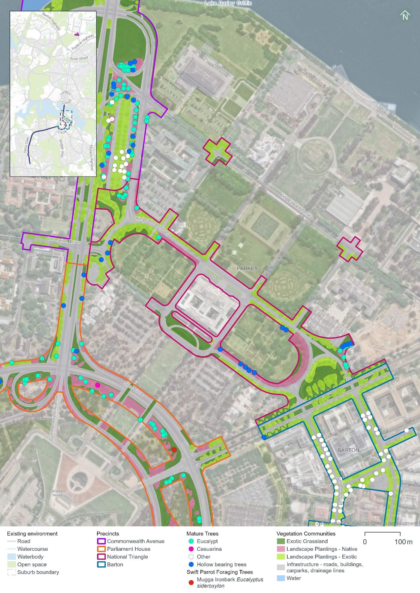
Hollow-bearing trees and mature trees
A total of 14 hollow-bearing trees and 20 mature trees have been recorded in the National Triangle precinct. These trees provide suitable breeding and/or foraging habitat for woodland birds including those identified as having a moderate or high likelihood of occurrence.
The majority of the recorded hollow-bearing trees are species that are endemic to the ACT. A list of hollow-bearing and mature native tree species across the Project area is provided in Section 11.2.1 of Chapter 11 (Project-wide issues). Table 14-20 summarises the number of hollow-bearing and mature trees within the National Triangle precinct and is shown in Figure 14-9.
Field surveys carried out between 2022 and 2024 have identified evidence of some of the hollows being actively used with birds (including Gang-gang Cockatoos) entering and leaving the hollows and displaying breeding behaviours (i.e. chewing around the hollow entrance).
| Precinct | Number of hollow-bearing trees | Hollows1 | Number of mature trees | ||||
|---|---|---|---|---|---|---|---|
| Extra-small (<2.5 cm) | Small (2.5-5 cm) | Medium (5-10 cm) | Large (10-30 cm) | Extra-Large (>30 cm) | |||
|
National Triangle |
14 |
2 |
4 |
1 |
5 |
5 |
20 |
Notes:
- Some hollow-bearing trees have been recorded as containing more than one hollow.
Threatened fauna habitat
The Golden Sun Moth (Synemon plana) is listed as vulnerable under both the EPBC Act and the NC Act. A total area of 0.44 ha of potential Golden Sun Moth habitat has been recorded within the National Triangle precinct, which has been identified as high-density Chilean needlegrass habitat (refer to Figure 14-10). However, no Golden Sun Moth individuals have been recorded in National Triangle precinct. Other Golden Sun Moth individuals and populations, and habitat across the Project area are identified in Section 11.2 of Chapter 11 (Project-wide issues).
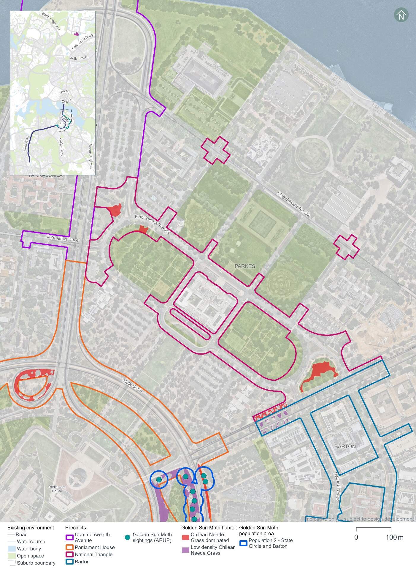
Other potential threatened fauna habitat identified within the National Triangle precinct includes:
- Gang-gang Cockatoo (Callocephalon fimbriatum) (listed as endangered under both the EPBC Act and the NC Act) - the National Triangle precinct supports 1.16 ha of foraging habitat and seven breeding trees for the species (refer to Figure 14-11)
- Superb Parrot (Polytelis swainsonii) (listed as vulnerable under both the EPBC Act and the NC Act) - the National Triangle precinct supports 1.16 ha of foraging habitat for this species (refer to Figure 14-11)
- Diamond Firetail (Stagonopleura guttata) (listed as vulnerable under both the EPBC Act and the NC Act.) - 1.16 ha of the Landscape Planting - Native community has been identified within the National Triangle precinct and may provide suitable habitat for the Diamond Firetail (refer to Figure 14-11).
No habitat was identified in the National Triangle precinct for the Swift Parrot, Perunga Grasshopper (Perunga ochracea), Canberra Raspy Cricket (Cooraboorama canberrae), Key's Matchstick Grasshopper (Keyacris scurra), or Striped Legless Lizard (Delma impar).
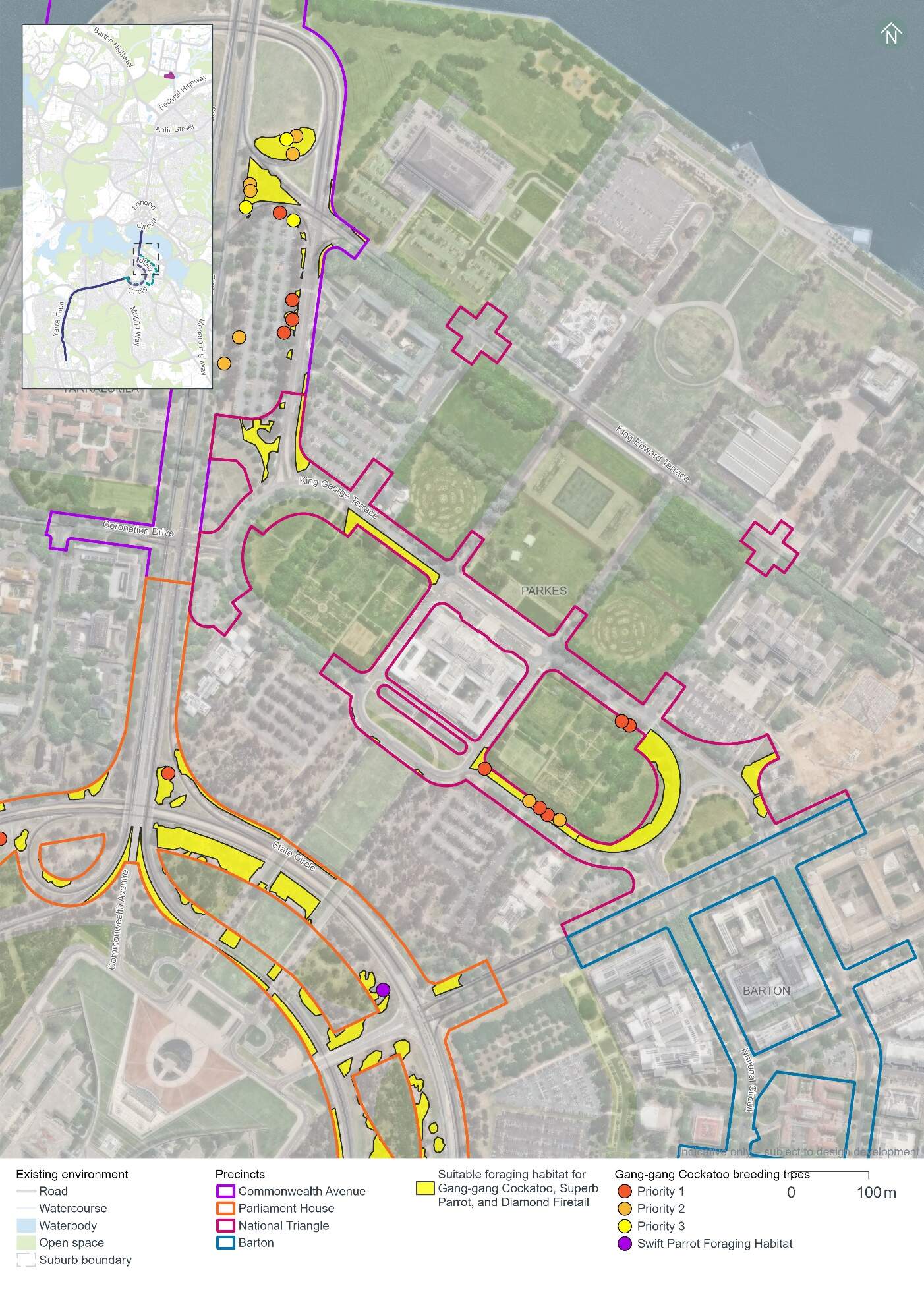
Threatened flora and pest plants
No threatened or rare flora species have been recorded in the National Triangle precinct. Impacts to threatened or rare flora species are therefore not anticipated.
One pest plant species declared under the Pest Plants and Animals Act 2005 (PP&A Act) has been recorded in the National Triangle precinct. The pest plant species, the Chilean needlegrass (Nassella neesiana), is also a Weed of National Significance.
14.4.2 Potential impacts - construction
The following section summarises the potential impacts of the Project on biodiversity as a result of construction in the National Triangle precinct.
Vegetation assessment
The Project design has been developed with the aim of avoiding direct and indirect impacts to MNES and other biodiversity values in the landscape. Through this process, a clearance footprint has been defined, as shown in Figure 14-12. Vegetation clearing would not be permitted outside this clearance footprint.
Vegetation clearing in this precinct would be required to construct the National Triangle-Barton alignment option only. No vegetation clearing in this precinct would be required for the State Circle East alignment option.
Native and non-native vegetation within the clearance footprint is comprised of three communities as summarised in Table 14-21. Only 0.08 hectares of this vegetation is characterised as native, and all of it is landscape planting rather than remnant native vegetation.
| Vegetation community | Area (ha) |
|---|---|
|
Landscape plantings - Native |
0.08 |
|
Landscape plantings - Exotic |
0.41 |
|
Exotic grassland |
0.40 |
|
Total vegetation |
0.89 |
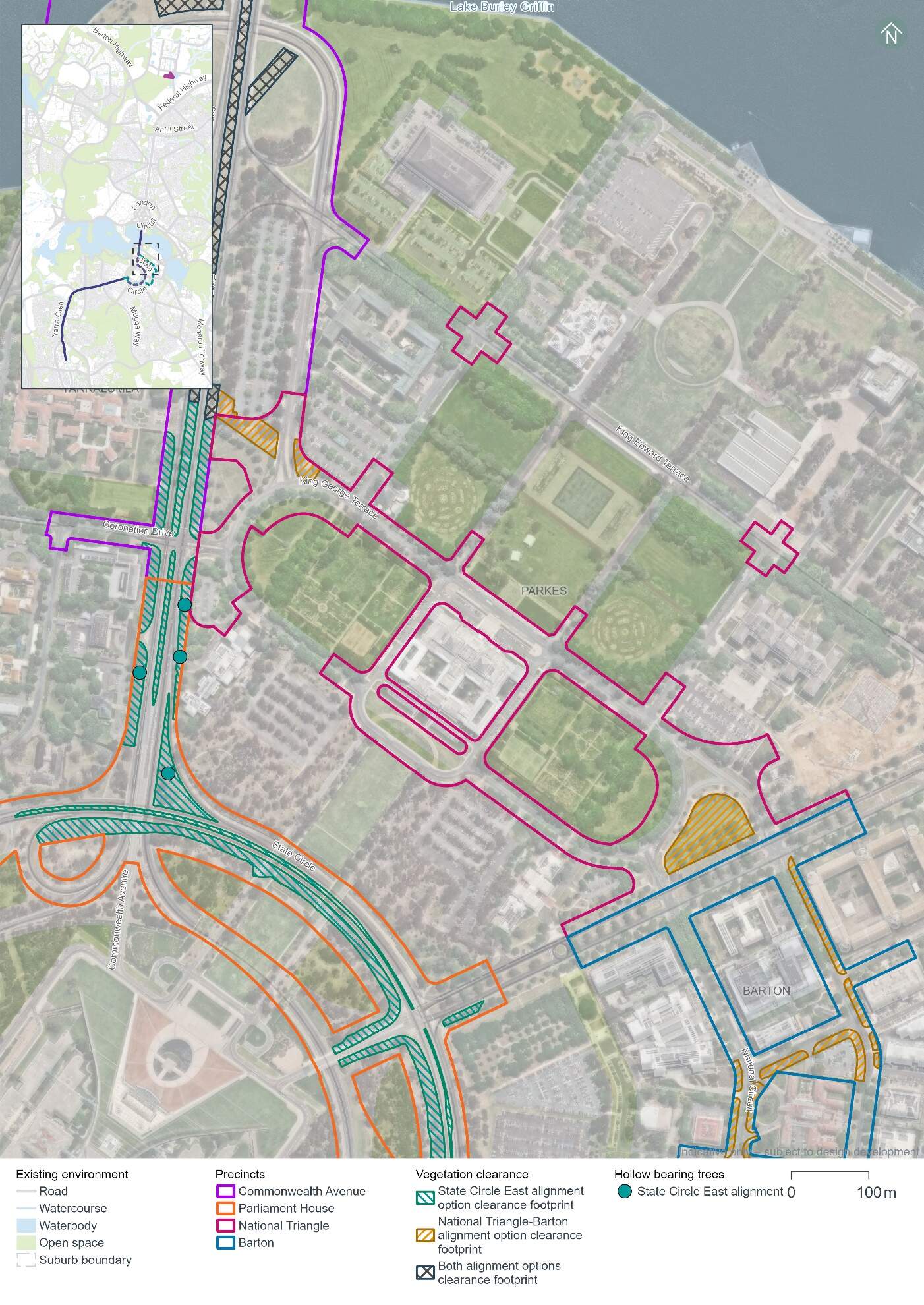
Three mature native trees have been recorded in the clearance footprint in the National Triangle precinct. These trees provide suitable breeding and/or foraging habitat for woodland birds including those identified as having a moderate or high likelihood of occurrence.
No hollow-bearing trees have been recorded within the clearance footprint in the National Triangle precinct.
Threatened fauna
Potential impacts on threatened fauna within the clearance footprint in the National Triangle precinct would include impacts on the following through habitat removal:
- Gang-gang Cockatoo - 0.08 ha of foraging habitat, which when taken in total with all clearing required for the Project, has the potential to interfere with the recovery of the species
- Superb Parrot - 0.08 ha of foraging habitat for Superb Parrot, which when taken in total with all clearing required for the Project, has the potential to interfere with the recovery of the species
- Diamond Firetail - 0.08 ha of the Landscape Planting - Native community within the precinct which may provide suitable habitat for the species
- Golden Sun Moth - 0.23 ha of high-density Chilean needlegrass which may may provide suitable habitat for the species.
Potential impacts on threatened fauna habitat across the clearance footprint is discussed further in Section 11.2.2 of Chapter 11 (Project-wide issues).
No habitat has been identified in the National Triangle precinct clearance footprint for the Swift Parrot, Perunga Grasshopper, Canberra Raspy Cricket, Key's Matchstick Grasshopper, or Striped Legless Lizard.
Indirect impacts
Native vegetation and habitat adjacent to the clearance footprint, and species using air space above the clearance footprint may be indirectly impacted by the construction works if appropriate management and mitigation measures are not implemented. Management and mitigation measures for biodiversity are discussed further in Chapter 21 (Environmental management and mitigation measures). Potential indirect impacts of construction activities may include:
- Spread of invasive species in the clearance footprint from equipment and machinery
- Noise and vibration impacts on fauna within the vicinity of construction works
- Erosion, sedimentation, and dust impacts on biodiversity values during ground disturbing works
- Waste impacts associated with the storage of fuels and disposal of waste from new equipment and the removal of existing infrastructure
- Increased light pollution on sensitive habitats and species from increased light spill and lighting intensity during construction works
- Fauna strike by construction vehicles within and adjacent to existing roadways.
Further detail on these indirect impacts for construction activities is discussed in Section 11.2.2 of Chapter 11 (Project-wide issues).
14.4.3 Potential impacts - operation
Native vegetation and habitat adjacent to the clearance footprint, and species using air space above the Project have the potential to experience indirect impacts from the operation of the Project, for example:
- Noise and vibration impacts within the vicinity of the alignment, from light rail operations
- Increased light pollution on sensitive habitats and species, for example due to lighting around light rail stops
- The addition of light rail vehicles within an existing transport corridor increasing the risk of fauna strike.
There would be no over-head wiring installed in this precinct as part of the Project and therefore there would be no risk of fauna strike with over-head wires. Further detail on these indirect impacts for operational activities is discussed in Section 11.2.3 of Chapter 11 (Project-wide issues).
14.4.4 Precinct specific management and mitigation measures
The Project has sought to reduce and avoid impacts to MNES and other biodiversity values in the landscape, through the development of a clearance footprint within the Project area (refer to Figure 14-12).
Environmental management for this Project is detailed in Part C (Environmental management and conclusion). This includes construction and operational management and mitigation measures (where relevant) in Chapter 21 (Environmental management and mitigation measures) that are applicable to the Project as a whole.
No precinct-specific measures have been identified for biodiversity impacts in the National Triangle precinct.
14.5 Historic heritage
This section provides an assessment of the potential historic heritage impacts associated with the construction and operation of the Project within the National Triangle precinct. Further detail on the heritage impact assessment is provided in Technical Report 3 - Heritage. The methodology applied for this assessment is summarised in Chapter 10 (Assessment methodologies) and discussed in detail in Section 2 of Technical Report 3 - Heritage.
Historic cultural landscapes, natural heritage, and heritage views and vistas have been assessed on a Project-wide basis as such features span across multiple precincts (refer to Section 11.3 of Chapter 11 (Project-wide issues)).
14.5.1 Existing environment
This section provides an overview of the existing historic heritage features within the National Triangle precinct. It also considers the condition, integrity, and sensitivity to change of historic heritage features within the precinct.
Heritage character
The heritage character of the National Triangle precinct arises from its position at the centre of the National Triangle and the Parliament House Vista along the Land Axis (formed by the view line between Capital Hill and Mount Ainslie). The Parliament House Vista expresses clearly the Griffin Plan for Canberra (Griffin Plan) with the Land Axis serving as the central geometric feature around which the layout of Canberra was constructed. The National Triangle precinct directly intersects the centre of this Axis.
The National Triangle precinct also includes architecture, road geometry, plantings, and open spaces that reflect the status and function of the national capital and symbolises Australian politics and Government.
The historic heritage assessment identified 12 heritage places (nine listed, one nominated, and two unlisted) within and surrounding the National Triangle precinct, as noted below in Table 14-22 and shown in Figure 14-13.
| Heritage places | Description |
|---|---|
|
Commonwealth Heritage List |
|
|
Parliament House Vista |
The Parliament House Vista along the Land Axis is the most iconic of the intentional vistas created in the Griffin Plan. The open sweeping vista along the Land Axis is experienced in two directions and creates a dramatic view between Capital Hill and Mount Ainslie. The Aboriginal Tent Embassy is included in the Commonwealth Heritage List citation for the Parliament House Vista and is generally understood to be of high cultural significance to both the Aboriginal community and the wider population. This is due to it being significant as a place of political protest and action. The establishment of the embassy was a defining event which brought Aboriginal rights to an international arena. It represents the ongoing political struggle of Aboriginal people and is part of Australia's political heritage. Given this heritage place spans multiple precincts, it is assessed in Section 11.3 of Chapter 11 (Project-wide issues) and is not assessed further in this precinct assessment. |
|
King George V Memorial |
The King George V Memorial, located on the northern side of King George Terrace, is historically significant as a tangible example of the importance of the Australian Head of State within the Australian system of government. The statue commemorates King George V, Monarch at the time of the opening of the Old Parliament House. The memorial is a significant feature of the Parliament House Vista landscape and provides enframement to the Land Axis space. |
|
John Gorton Building (including the Communications Centre) |
The John Gorton Building on Parkes Place East is in an inter-war Stripped Classical style. Key features of this style displayed by the building include: the symmetrical facades; the division of the elevations into vertical bays; the occasional use of correct Classical details; the use of a basic Classical column form; and the expressed portico. The Communications Centre is a rare example of an underground bunker, significant for its associations with the nation's 'cold war' activities. |
|
Old Parliament House Gardens |
The Old Parliament House Gardens, located to the north west of Old Parliament House, are historically significant for their contribution to understanding the operations of Old Parliament House, being closely integrated into the daily life of Old Parliament House during its operations as a place of relaxation, recreation and a venue for special events. Beyond the gardens, the trees of King George and Queen Victoria Terraces, and adjacent avenue walks contribute green canopy backdrops to the gardens. |
|
National Library of Australia and surrounds |
The National Library of Australia and surrounds is a good example of the Late Twentieth Century Stripped Classical style, and part of the significant cultural landscape of the Parliamentary Triangle. It occupies a prominent and strategic location on the western side of the Triangle, making it one of Canberra's landmark features. The library is valued by the community for its cultural use as a library, for its national collections, and for its exhibitions. |
|
East Block Government Offices |
East Block Government Offices is on the west side of Kings Avenue and is significant as one of the earliest government buildings in Canberra and is an integral component of the National Triangle landscape. It demonstrates architecture suited to sit within a designed landscape of related buildings and spaces. |
|
National Rose Gardens |
The National Rose Gardens, located on the north side of King George Terrace to the east of Old Parliament House, are historically significant as Australia's first national gardening project. They were planned to represent cooperation between the Commonwealth and the States, and roses were contributed by all states in Australia. |
|
Commonwealth Heritage List and National Heritage List |
|
|
Old Parliament House and Curtilage (refer to Figure 14) |
Old Parliament House and Curtilage is a nationally significant heritage place, with historical, rarity, research, and characteristic heritage values. It has aesthetic and social heritage value to the Australian community, is an expression of creative and technical achievement, and is associated with many significant people. It is located centrally in the National Triangle, acting as a physical representation of democracy in the nation. |
|
The High Court and National Gallery Precinct (including High Court of Australia and National Gallery of Australia) |
The High Court and National Gallery Precinct, located to the north of King Edward Terrace, is significant for demonstrating the development of the National Triangle as a home for national institutions. It is visually prominent in the National Triangle due to the buildings' monumental Brutalist architecture on the eastern side of the Land Axis. |
|
ACT Heritage Register |
|
|
Canberra's pre-cast concrete bus shelters (object) (nominated) |
Canberra's precast concrete bus shelters are iconic landmarks in Canberra's city and garden suburbs because of their aesthetic distinctiveness, technical innovation, functionality of form and meaning to the community. About 90% are still understood to be in use today. The bus shelters have been moved as needed to locations throughout Canberra. It is understood that there is currently one precast concrete bus shelter in the Project Area, on King George Terrace to the north-west of the intersection with Parkes Place East. |
|
Unlisted significant heritage places |
|
|
Roads on national land - Commonwealth Avenue, Kings Avenue, State Circle, and Capital Circle |
Commonwealth Avenue and Kings Avenue are two of the three original major avenues for Canberra and together with Constitution Avenue they form the Parliamentary Triangle. Their symmetry, tree-lined avenues, plantings, landscape setting, and geometry contribute to an understanding of the Griffin Plan. They are significant as individual places and as part of the broader historical urban designed landscape of Canberra. State Circle and Capital Circle encircles Parliament House, framing Capital Hill. The smoothed contours, grassed verge edges, and massed native plantings between State and Capital Circles are significant by creating a 'natural Australian' aesthetic as the appropriate setting for the nation's parliament and reflect the principles of Canberra as a designed city in the landscape. Given this heritage place spans multiple precincts, it is assessed in Section 11.3 of Chapter 11 (Project-wide issues) and is not considered further in this precinct assessment. |
|
Canberra: the Planned National Capital |
Canberra's planned national landscape is a significant expression of the Griffin Plan that is highly valued by the Canberra and Australian communities. It is formed of public parklands, significant views along axes and across the Central National Area, tree-lined boulevards, a geometric layout, and Lake Burley Griffin. The landscape is nationally significant due to its:
Given this heritage place spans multiple precincts, it is assessed in Section 11.3 of Chapter 11 (Project-wide issues). It also applies to the landscape of Canberra as a whole and is therefore excluded from Figure 14-13 and is not considered further in this precinct assessment. |
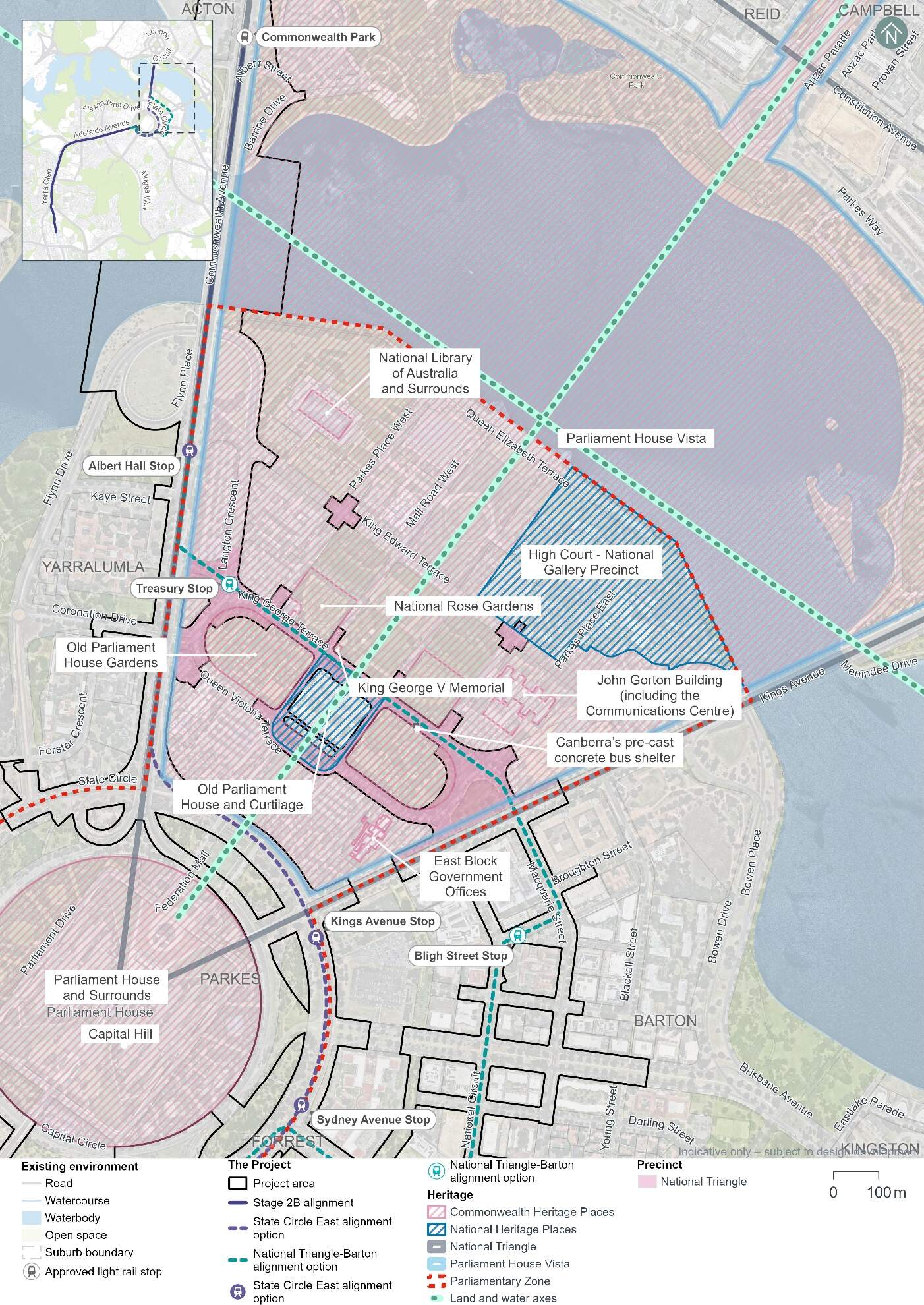
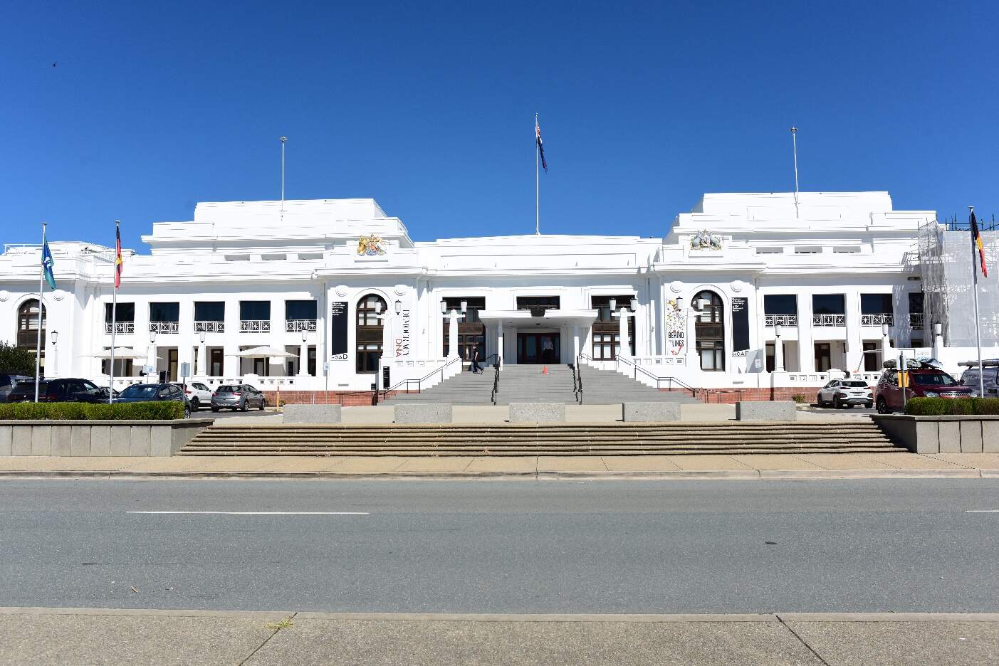
Condition, integrity, and sensitivity to change
The existing heritage within the National Triangle precinct is generally in good condition. The features of Parliamentary Zone and National Triangle are generally well maintained. Some trees are in poorer health but most are in fair to good condition. The historical structures associated with the precinct are in use and maintained.
The integrity of the heritage values is good. The original design character of the Griffin Plan and the historical layers of the landscape are generally intact and legible. Some changes have been made over time which have obscured the intended primacy of symbolic public buildings in the landscape and the symmetry of landscape design in the Griffin Plan, for example alterations to the original Griffin road geometry in a way which has obscured the historical layout, and the construction of a multi-storey carpark adjacent to the John Gorton Building.
The precinct is highly sensitivity to change due to the landscape being of outstanding national importance, central expression of the Griffin Plan and through its implementation by subsequent custodians.
14.5.2 Potential impacts - construction
Table 14-23 summarises the potential construction impacts of the Project on heritage places in the National Triangle precinct. Construction of the State Circle East alignment option would not have any impacts on heritage places within the National Triangle precinct.
| Heritage place | Construction impact National Triangle-Barton alignment option |
|---|---|
|
Commonwealth Heritage List |
|
|
King George V Memorial |
Minor
|
|
John Gorton Building (including the Communications Centre) |
Nil
|
|
Old Parliament House Gardens |
Nil
|
|
National Library of Australia and surrounds |
Nil
|
|
East Block Government Offices |
Nil
|
|
National Rose Gardens |
Nil
|
|
Commonwealth Heritage List and National Heritage List |
|
|
Old Parliament House and curtilage |
Minor
|
|
The High Court and National Gallery Precinct |
Nil
|
|
ACT Heritage Register |
|
|
Canberra's pre-cast concrete bus shelters (object) (nominated) |
Nil
|
Construction impacts on Parliament House Vista, Parliament House and surrounds, Roads on national land - Commonwealth Avenue, Kings Avenue, State Circle, and Capital Circle, and Canberra: the Planned National Capital have been assessed in Section 11.3 of Chapter 11 (Project-wide issues).
14.5.3 Potential impacts - operation
Table 14-24 summarises the potential operation impacts of the Project on heritage places in the National Triangle precinct. Operation of the State Circle East alignment option would not have any impacts on heritage places within the National Triangle precinct.
| Heritage place | Operation impact National Triangle-Barton alignment option |
|---|---|
|
Commonwealth Heritage List |
|
|
King George V Memorial |
Nil
|
|
John Gorton Building (including the Communications Centre) |
Minor
|
|
Old Parliament House Gardens |
Nil
|
|
National Library of Australia and surrounds |
Nil
|
|
East Block Government Offices |
Nil
|
|
National Rose Gardens |
Nil
|
|
Commonwealth Heritage List and National Heritage List |
|
|
Old Parliament House and curtilage |
Moderate to significant
|
|
The High Court and National Gallery Precinct |
Nil
|
|
ACT Heritage Register |
|
|
Canberra's pre-cast concrete bus shelters (object) (nominated) |
Nil
|
Operation impacts on Parliament House Vista, Parliament House and surrounds, Roads on national land - Commonwealth Avenue, Kings Avenue, State Circle, and Capital Circle, and Canberra: the Planned National Capital have been assessed in Section 11.3 of Chapter 11 (Project-wide issues).
14.5.4 Precinct specific management and mitigation measures
Environmental management for this Project is detailed in Chapter 21 (Environmental management and mitigation measures). This includes construction and operational mitigation measures to manage historic heritage impacts, that are applicable to the Project as a whole.
No precinct-specific measures have been identified for historic heritage impacts in the National Triangle precinct.
14.6 Landscape character and visual amenity
This section provides an assessment of the potential landscape character and visual amenity impacts associated with the construction and operation of the Project within the National Triangle precinct. Further detail on the landscape character and visual amenity assessment is provided in Technical Report 10 - Landscape character and visual amenity. The methodology applied for the assessment is summarised in Chapter 10 (Assessment methodologies) and Section 2 of Technical Report 10 - Landscape character and visual amenity.
The landscape character assessment describes the physical, cultural, and heritage attributes of the landscape, planning designations, and desired character within each of the precincts. The assessment of visual impact has considered the impact of change on the views available to people and their visual amenity.
For the purposes of this assessment, the precinct boundaries have been expanded beyond the Project area, as shown in Figure 14-15.
14.6.1 Existing environment
The National Triangle precinct extends along King George Terrace, passing between Old Parliament House and the Aboriginal Tent Embassy, and is bordered by Commonwealth Avenue and Kings Avenue. The precinct features open spaces and iconic buildings such as Old Parliament House, the Australian War Memorial, and the National Library.
Old Parliament House lies directly adjacent to the National Triangle-Barton alignment option and is located centrally to the National Triangle, intersecting the vista along the Griffin's Land Axis (Land Axis) between Parliament House and The Australian War Memorial. The adjacent Aboriginal Tent Embassy is a symbolic site established in 1972 by Aboriginal activists in Canberra. Its significance lies in its role as a focal point for Aboriginal political activism, advocating for land rights and self-determination within the Australian political landscape. The precinct contains many heritage items in close proximity to each other.
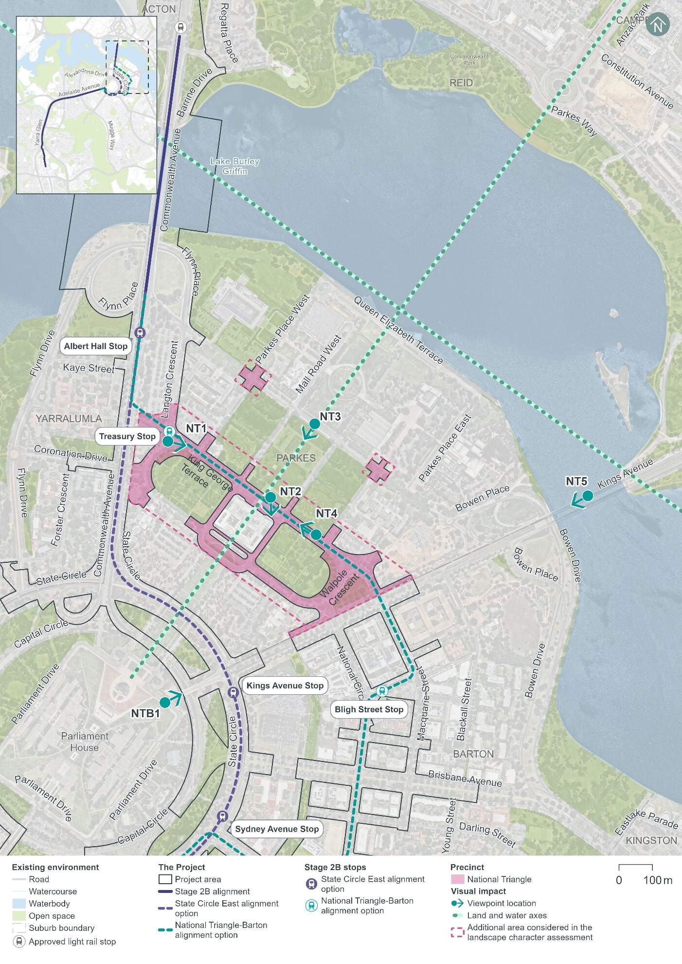
Landscape character
The key aspects of the landscape character in the National Triangle precinct can be seen in Figure 14-16 and Figure 14-17. The National Triangle precinct comprises a formal landscape, with the geometry of the road and block network responding to the triangular shape of the broader land parcel, bisected and bounded by avenues and axes that are integral to the structure of the city. Views and vistas along King George Terrace and the Land Axis are compartmentalised within the landscape by the formal planting along road corridors or along boundaries (refer to Figure 14-16). This results in a framing of Old Parliament House and other buildings. Vegetation includes formal tree planting with large areas of open turf and some smaller gardens, including the National Rose Garden. Land uses within the precinct are predominantly National Capital use, with some commercial (i.e.restaurants and cafés). Surface level car parks within the precinct service substantial campuses and are fringed by vegetation.
The precinct contains many heritage elements, the most notable for this area being the Parliament House Vista, listed on the Commonwealth Heritage List (CHL). This listing includes the entire precinct, however, key attributes focus on the vistas along the Land Axis between Parliament House and Mount Ainslie including other important items such as Old Parliament House.
The symbolic weight of the Land Axis makes this an important space for cultural functions. The Aboriginal Tent Embassy (which is included in the Parliament House Vista listing in the CHL) is located within the Land Axis. The landscape between Old Parliament House (refer to Figure 14-17) and the Australian War Memorial along the Land Axis emphasises the nationally significant architecture.
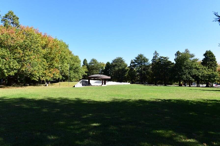
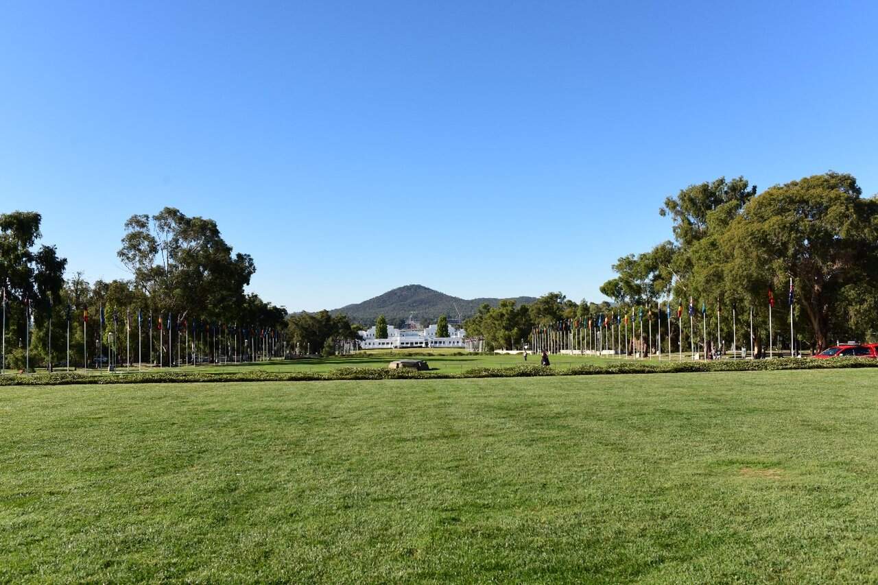
Viewpoints
Representative viewpoints that have been identified to assess visual impacts to the National Triangle precinct and are shown in Figure 14-15 and described in Table 14-25. These viewpoints have been assessed for the National Triangle-Barton alignment option only. Images of all viewpoints can be found in Technical Report 10 - Landscape character and visual amenity.
| Viewpoint | Description | Sensitivity rating |
|---|---|---|
|
Viewpoint NT1: Magna Carta Place |
This viewpoint is located on King George Terrace, looking south-east along the road corridor towards Old Parliament House. The viewpoint is located adjacent to Magna Carta Place (refer to Figure 14-20). The central view comprises the northern turf verge and road pavement of King George Terrace, which extends from the foreground into the background. Visual receptors are likely to be pedestrians, cyclists, or motorists passing by this viewpoint. The sensitivity to change of this viewpoint is high. The viewpoint is positioned within an important area from a heritage and planning perspective. |
High |
|
Viewpoint NT2: Old Parliament House |
This viewpoint is located at Parkes Place, looking south towards Old Parliament House and along King George Terrace. The view is situated within the Land Axis, adjacent to the Aboriginal Tent Embassy. The existing view includes the narrow road corridor towards the Old Parliament House building and forecourt. This viewpoint would be a popular tourist destination for visual receptors whereby the attention would be focussed on the architecture at this location. The quality of the view is paramount to the visitor experience. Those at the Aboriginal Tent Embassy would experience more prolonged views of this viewpoint than other visual receptors, however this view is only one of many available to protestors at the Aboriginal Tent Embassy. The sensitivity to change of this viewpoint is high. The viewpoint is positioned within an important area from a heritage and planning perspective. |
High |
|
Viewpoint NT3: Federation Centenary Fountains |
This viewpoint is located within Parkes Place, looking south-west towards Old Parliament House and the Aboriginal Tent Embassy from the north-eastern edge of Federation Centenary Fountains (refer to Figure 14-18). The view is dominated by the base of the Federation Centenary Fountains and surrounding patterned pavement. This viewpoint would be a visitor destination for visual receptors whereby the attention would be focussed on the architecture and vistas at this location. The quality of the view is paramount to the visitor experience. The sensitivity to change of this viewpoint is high. The viewpoint is positioned within an important area from a heritage and planning perspective. |
High |
|
Viewpoint NT4: King George Terrace East |
This viewpoint is located on King George Terrace, looking north-west along the road towards Old Parliament House near the intersection with Parkes Place East (refer to Figure 14-19). The central view comprises the road pavement of King George Terrace extending from the foreground to the background, lined with street trees. Visual receptors are likely to be pedestrians, cyclists, or motorists passing by this viewpoint. The sensitivity to change of this viewpoint is high. The viewpoint is positioned within an important area from a heritage and planning perspective with views towards Old Parliament House and surrounding landmarks. |
High |
|
Viewpoint NT5: Kings Avenue Bridge |
This viewpoint is located centrally on the Kings Avenue Bridge looking south-west towards Parliament House. The view comprises the separated east and westbound carriageways and northern footpath of Kings Avenue, extending west. While most of the visual receptors who would see this view would be transiting through the area to another destination, a proportion of these would be visitors who would be travelling along Kings Avenue between parks or landmarks due to their value as destinations within Canberra. These receptors would be more focussed on the view, particularly as the view culminates in Parliament House looking in one direction and the Australian-American Memorial looking in the other. The sensitivity of the viewpoint is high due to the importance of views along main avenues, particularly Kings Avenue, as one side of the National Triangle terminating in a landmark element at either side. |
High |
|
Viewpoint NTB1: Parliament House North-east |
This viewpoint is located on the lawn at the northern corner of Parliament House looking north-east along Kings Avenue towards the Australian-American Memorial. The foreground of the view is dominated by the manicured green lawn of Parliament House, sloping down to Parliament Drive which passes through the middle ground. The sensitivity to change of this viewpoint is negligible as the Project would not be seen from this viewpoint. No further assessment of this alignment option from this viewpoint will be undertaken and are assumed to be negligible. |
Negligible - not assessed further |

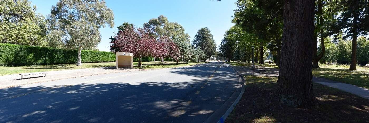
Night-time lighting
The National Triangle precinct holds a number of landscape and heritage sensitivities with a key focus on vistas, particularly along the Land Axis. The National Triangle is an area of A3: Medium district brightness based on Australian Standard 4282:2023 (Standards Australia, 2023), with low level lighting of streetscapes to ensure the prominence of the feature lighting of nationally significant buildings.
Relevant design requirements of strategy 1a of the National Capital Authority's (NCA) Outdoor Lighting Policy for the National Triangle precinct include:
- Illuminate the Griffins' Land Axis by retaining the existing Anzac Parade street lighting and illumination of Federation Mall
- Use full cut-off light fittings in all landscape areas, roads, paths, and car parks within the Central National Area
- Align lighting hardware to strengthen the framing of the National Triangle, main avenues, and formally landscaped open spaces.
Due to the removal of private vehicle movement along the King George Terrace corridor, passive surveillance would be lessened within the precinct. Pedestrian lighting would be provided along the corridor to increase safety for the community while framing views along King George Terrace and toward Old Parliament House, reinforcing the integrity of the visual structure throughout the precinct.
14.6.2 Potential impacts - construction
Landscape character impact assessment
The construction of the Project would result in both the addition and loss of elements within the National Triangle precinct, including:
- The addition of temporary fencing, hoarding, signage, and traffic safety equipment
- Removal of existing vegetation (most notably, trees), furniture, and signage, as needed
- Activities including earthworks, track construction, drainage adjustments, and road improvements
- Construction of structures, including light rail stops
- Installation of lighting, signage, and landscaping
- Temporary traffic changes
- Establishment of construction compounds.
These changes would alter many aesthetic aspects and key characteristics within the precinct.
Construction activities in any one location would be temporary and experienced over the short term (up to five years).
As such, the magnitude of change during construction would be high within the National Triangle precinct due to the visual clutter of construction and the removal of trees. This would result in a high adverse impact on landscape character during construction.
Visual impact assessment
The visual impact assessment considered the sensitivity of existing viewpoints to change and the magnitude (scale, character, and distance) of the change of view. These viewpoints have been assessed for the National Triangle-Barton alignment option only. During the construction phase within the National Triangle precinct, in most cases the overall impact at each viewpoint has been assessed as being high to moderate due to:
- High sensitivity of most viewpoints to change
- High heritage and aesthetic values of views across this precinct
- High magnitude of works anticipated throughout construction that would be visible in the fore, middle, and background of most viewpoints.
A description of the anticipated change in view and associated potential impacts on the Project during construction is provided in Table 14-26.
| Viewpoint | Anticipated change in view | Impact rating |
|---|---|---|
|
Viewpoint NT1: Magna Carta Place |
This viewpoint would be inaccessible during construction due to the close proximity to construction works. The magnitude of change during construction cannot be assessed as this viewpoint would not be accessible during construction and is therefore deemed negligible. This combined with a high sensitivity rating makes the overall impact negligible. |
Sensitivity: High |
|
Magnitude: Negligible |
||
|
Overall impact: Negligible |
||
|
Qualitative rating: Neutral |
||
|
Viewpoint NT2: Old Parliament House |
During construction, private vehicle access along King George Terrace would be removed. The change would be in contrast to the existing, recessive road corridor and iconic architecture at this location and would be visible in the fore and middle ground of this view. The Project would result in the addition of construction activity and equipment which is likely to at least partially screen views to Old Parliament House and its gardens and is positioned on the Griffins' Land Axis, and in close proximity to the Aboriginal Tent Embassy. |
Sensitivity: High |
|
Magnitude: High |
||
|
Overall impact: High |
||
|
Qualitative rating: Adverse |
||
|
Viewpoint NT3: Federation Centenary Fountains |
During construction, private vehicle access along King George Terrace would be removed. From this viewpoint, which is 200 m away from the proposed changes at its nearest point, the discernible construction activity would include:
The construction would be seen in the background of the view however, the work is likely to be seen in front of Old Parliament House. Changes would be somewhat prominent within the view due to the contrast against the stark white façade of Old Parliament House, but the overall prominence of the works would be diminished by the distance of viewing. |
Sensitivity: High |
|
Magnitude: Moderate |
||
|
Overall impact: High to moderate |
||
|
Qualitative rating: Adverse |
||
|
Viewpoint NT4: King George Terrace East |
During construction, private vehicle access along King George Terrace would be removed. The construction would be seen in the foreground and middle ground of the view and over a large proportion of the view. Construction activity would be in contrast to the existing, established landscape and would result in an adverse effect on the quality of the view. The visual clutter of construction activity would become a dominant feature of the view, with additional large elements and construction activities evident within the view. |
Sensitivity: High |
|
Magnitude: High |
||
|
Overall impact: High |
||
|
Qualitative rating: Adverse |
||
|
Viewpoint NT5: Kings Avenue Bridge |
A glimpse of the construction activity would be seen framed by the mature avenue tree planting that focuses the view from this location along Kings Avenue to the focal point at Parliament House. The viewing distance between the viewpoint and the Project is greater than 650 m but some construction activity would be visible from this location. The construction would result in visual clutter within the Kings Avenue view corridor. While limited construction activity is likely to be seen in detail, the activity is likely to result in a disruption in the continuity of the view of the avenue leading up to Capital Hill. |
Sensitivity: High |
|
Magnitude: Low |
||
|
Overall impact: Moderate |
||
|
Qualitative rating: Adverse |
||
|
Viewpoint NTB1: Parliament House North-east |
The sensitivity of this view to construction of the Project is negligible. Therefore, potential impacts at this viewpoint have not been assessed further and are assumed to be negligible. |
Sensitivity: Negligible |
|
Magnitude: Negligible |
||
|
Overall impact: Negligible |
||
|
Qualitative rating: Neutral |
Night-time visual impact assessment
Works in the National Triangle precinct may need to be undertaken outside standard construction hours (Monday to Saturday, 7am to 6pm).
Temporary lighting would be required within the construction compounds to prioritise safety and security of the facility. Construction compounds within the precinct would be located within:
- 21 Queen Victoria Terrace
- The open space adjacent to the intersection of King George Terrace and Kings Avenue.
For these reasons, the visual impact during construction at night would be high adverse.
14.6.3 Potential impacts - operation
Landscape character impact assessment
The assessment of landscape effects considers how the Project will impact the landscape more broadly. It is based on the landscape's sensitivity to change and the expected scale of change. Table 14-27 summarises the anticipated changes and potential impacts of the Project on landscape character.
| Alignment option | Anticipated change | Impact rating |
|---|---|---|
|
National Triangle-Barton alignment option only |
The Project would result in the addition of the light rail infrastructure, including a light rail stop with canopy, along King George Terrace which would comprise a change to a large portion of the precinct. The Project would thoughtfully integrate with the existing infrastructure and preserve key spatial characteristics, including through the use of wire-free running. The central road within the precinct would shift from cars to light rail, with some portions of the road effectively 'removed' due to the installation of green track, which would characteristically shift these areas to resemble the more open turfed areas on either side of the corridor. While the Project would result in the addition of light rail infrastructure within an existing green space at the north-western end of King George Terrace, linking this road with Commonwealth Avenue, there would be an overall increase in the amount green space (softscape) throughout the precinct due to the removal of hard road surface (replaced with green track), as well as the replacement of part of Walpole Crescent with turf. Changes to the traffic arrangements would result in a positive visual outcome within the Griffins' Land Axis, particularly in front of Old Parliament House and the Aboriginal Tent Embassy, through the removal of visual clutter including parking along King George Terrace and the pedestrianisation of the plaza. While the addition of light rail infrastructure would comprise a new element within this precinct, the low visual prominence of the trackform within key view corridors, particularly along the Griffins' Land Axis, and embedding the design within the surrounding landscape through the use of green track would allow it to characteristically align with the landscape character. The Treasury Stop would be the most substantial new element within the precinct, comprising a new architectural element. The stop would be some 100 m to the north-west of the Commonwealth Heritage Listed Old Parliament House Gardens, inclusive of Magna Carta Place, however, would retain the geometric structure of the Griffin Plan. |
Sensitivity: High |
|
Magnitude: High |
||
|
Overall impact: High |
||
|
Qualitative rating: Beneficial |
Visual impact assessment
The visual impact assessment considered the sensitivity of existing viewpoints to change and the magnitude (scale, character, and distance) of the change of view. These viewpoints have been assessed for the National Triangle-Barton alignment option only. During operation within the National Triangle precinct, overall impacts varied greatly between viewpoints, ranging from high to negligible due to:
- Varied visibility of the Project from each viewpoint
- Varied visual blending of the Project with the surrounding view
- Pedestrianisation of the precinct.
Neutral to beneficial changes to visual amenity would also occur at some viewpoints due to the preservation of turf or trees in the median/verges, addition of tree plantings, and installation of sections of green track within the existing road corridor.
A description of the anticipated change in view and associated potential impacts on the Project during operation is provided in Table 14-28.
| Viewpoint | Anticipated change in view | Impact rating |
|---|---|---|
|
Viewpoint NT1: Magna Carta Place |
The Project would result in the addition of light rail infrastructure along King George Terrace. The viewpoint would be positioned at the south-eastern end of Treasury Stop. Tree planting along the alignment would reduce the impact of tree removal over time as the trees mature, although it is noted that a few trees would be removed within the existing view. Wire-free running would reduce any visual clutter associated with the Project at this location. The addition of the light rail corridor extending along the road, with passing LRVs would be visually prominent and would result in a contrast to the existing condition. King George Terrace would be changed from a road where cars could travel along to one with only LRVs. The changes would be permanent, seen from close proximity, within the central portion of the view, extending into the distance. An indicative visualisation of the Project, once operational, from Viewpoint NT1 is provided in Figure 14-21. |
Sensitivity: High |
|
Magnitude: High |
||
|
Overall impact: High |
||
|
Qualitative rating: Adverse |
||
|
Viewpoint NT2: Old Parliament House |
The Project would result in the addition of light rail infrastructure, passing LRVs, and the removal of traffic lanes along King George Terrace. The removal of street parking and vehicle movement would reduce the level of road vehicle activity within the view, with the space catering primarily to pedestrians and LRVs. The changes spread across the entire view are visually unobtrusive, primarily at ground level. Changes to the use of the road corridor and removal of parking would be the most substantial change. The view to Old Parliament House would remain largely unchanged due to the low profile of the infrastructure, which includes wire-free running. |
Sensitivity: High |
|
Magnitude: Low |
||
|
Overall impact: Moderate |
||
|
Qualitative rating: Beneficial |
||
|
Viewpoint NT3: Federation Centenary Fountains |
The light rail trackform would not be visible from this viewpoint. The most substantial changes to the view would be the removal of street parking and light vehicles moving along King George Terrace within the view as well as the addition of passing LRVs. Wire-free running would reduce any visual clutter associated with the Project at this location. The magnitude of change experienced at this viewpoint at operation of the Project would be negligible. Passing and parked cars within the view would be replaced with passing LRVs. |
Sensitivity: High |
|
Magnitude: Negligible |
||
|
Overall impact: Negligible |
||
|
Qualitative rating: Neutral |
||
|
Viewpoint NT4: King George Terrace East |
The Project would result in the shift in the road corridor usage from vehicular to light rail transport. The green track would visually soften the transport corridor within the view, tying the corridor into the surrounding parkland landscape. The Project would also result in the addition of light rail infrastructure and passing LRVs within the view and the removal of traffic lanes along King George Terrace. The retained avenue trees would delineate the transport corridor within the view. While the Project would result in a change within the corridor, these would be primarily beneficial outcomes to the view. As the road would be closed to traffic, there would be a reduction in vehicle traffic along the route, including the removal of on-street car parking within the view. This would result in a reduction in hardscape within the view, creating a green space that prioritises pedestrian movement as per the Griffin Legacy. The increase in trees would reinforce the avenue aesthetic within the view. Wire-free running would reduce any visual clutter associated with the Project at this location. |
Sensitivity: High |
|
Magnitude: High |
||
|
Overall impact: High |
||
|
Qualitative rating: Beneficial |
||
|
Viewpoint NT5: Kings Avenue Bridge |
At operation, passing LRVs would be seen crossing the intersection at King George Terrace and Macquarie Street in the background of the view. The remaining light rail infrastructure would not be discernible from this viewpoint due to the distance to these elements (greater than 650 m) as well as median and verge tree planting between the viewpoint and the Project. Passing LRVs would be visually similar to passing busses in the existing view. Wire-free running would reduce any visual clutter associated with the Project at this location. |
Sensitivity: High |
|
Magnitude: Negligible |
||
|
Overall impact: Negligible |
||
|
Qualitative rating: Neutral |
||
|
Viewpoint NTB1: Parliament House North-east |
The sensitivity of this view to operation of the Project is negligible. Therefore, potential impacts at this viewpoint have not been assessed further and are assumed to be negligible. |
Sensitivity: Negligible |
|
Magnitude: Negligible |
||
|
Overall impact: Negligible |
||
|
Qualitative rating: Neutral |
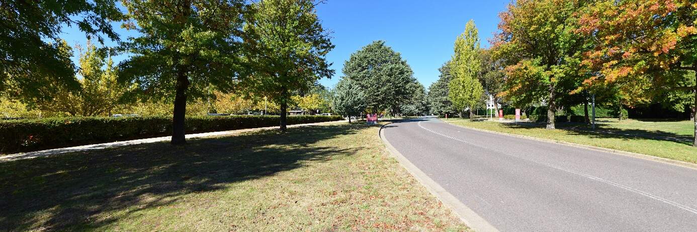
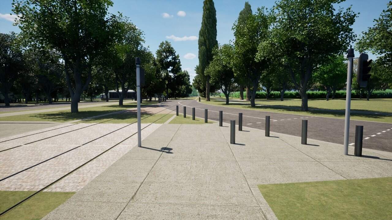
Night-time visual impact assessment
The priority within this precinct would be to deliver lighting that would respond to the sensitivities of the local landscape while prioritising the safety outcomes of pedestrians along King George Terrace through passive surveillance in response to the removal of private vehicle movement. The lighting along King George Terrace would be cut-off pedestrian lighting to contribute to the high quality landscape boulevard and not distract from the feature lighting of Old Parliament House and other nationally significant buildings.
While the addition of passing LRV headlights would be a new element within the Land Axis, these are temporary and would comprise an overall reduction of headlight movement within the corridor in response to the removal of private vehicle movement.
Lighting of the Treasury Stop adjacent to Magna Carter Place is vital to prioritise passenger safety at night and as a result this would create a lighting element within the road corridor and its surrounding environment. Existing pedestrian lighting is positioned along the path surrounding Magna Carta Place, however the park itself is not lit. Light spill from the stop is likely to affect the character of the public open space at night. Light spill from the stop may be beneficial to the perceived safety of the car park. While additional lighting would be required within the precinct, changes would not be experienced within the formal gardens of Old Parliament House due to tall hedging and mature tree planting.
Due to the reduction in traffic movement within the precinct at night and opportunities for placemaking within the Land Axis while prioritising the view corridor, there would be a noticeable improvement in visual amenity at night due to the Project.
The visual impact during operation for the National Triangle-Barton alignment option would result in a moderate beneficial change at night.
14.6.4 Precinct specific management and mitigation measures
Environmental management for this Project is detailed in Chapter 21 (Environmental management and mitigation measures). This includes construction and operational mitigation measures to manage landscape character and visual amenity, that are applicable to the Project as a whole.
In addition to the Project-wide measures, mitigation measures to manage landscape character and visual amenity impacts that are specific to the National Triangle precinct are shown in Table 14-29.
The Public Domain Master Plan (Appendix I) identifies design principles and guidance for the Project. These principles would be applied to the Project through ongoing design development and would contribute to management and mitigation of landscape and visual impacts of the Project during operation.
| ID | Objective | Management and mitigation measure | Timing |
|---|---|---|---|
|
LV11 |
Recognising the visual significance of the Aboriginal Tent Embassy and Old Parliament House |
Opportunities to enhance and celebrate the visual significance of the Aboriginal Tent Embassy and Old Parliament House through signage, landscaping and lighting will be developed in consultation with relevant stakeholders. |
Design and operation |
14.7 Socioeconomic
This section provides an assessment of the potential socioeconomic impacts associated with the construction and operation of the Project within the National Triangle precinct. Further detail on the socioeconomic assessment is provided in Technical Report 6 - Socioeconomic. The methodology applied for this assessment is summarised in Chapter 10 (Assessment methodologies) and discussed in detail in Section 4 of Technical Report 6 - Socioeconomic.
Some socioeconomic impacts would be applicable to the Project as a whole (including this precinct) and are assessed in Section 11.7 of Chapter 11 (Project-wide issues).
14.7.1 Existing environment
Community characteristics
The social area of influence encompasses the geographical extent of a project's potential impacts on people, including how positive and negative impacts may be reasonably perceived or experienced by different people. The area of social influence forms the study area for this assessment and is shown in Figure 11-1 in Section 11.7.
The assessment has considered the following in defining the social area of influence for the Project:
- Precincts: this term is applied to a geographic area designated for the purposes of the Project where people are most likely to experience both construction and operational socioeconomic impacts from the Project, or a level of direct impact. Statistical Area level 2 (SA2) areas have been selected for each precinct to represent the community where direct socioeconomic impacts could potentially occur. The National Triangle precinct includes the following SA2s:
- Parkes North SA2
- Parkes South SA2
- Corridor: this term is applied through the assessment where the spatial extent of socioeconomic impacts on people is generally broader than the precinct area. Statistical Area level 3 (SA3) areas have been selected to represent the corridor, including:
- South Canberra SA3
- Woden Valley SA3
- ACT: in some instances, the social area of influence is extended to a 'region' to reflect broader potential socioeconomic impacts, compared to the 'corridor'. This assessment refers to the 'region' as the Australian Capital Territory (ACT).
The characteristics of the communities within the area of social influence is described as the social baseline. The social baseline has been analysed by considering the human, social, economic, physical, and natural capital present around each precinct, the corridor, and the ACT. Capital refers to various forms of resources that contribute to the well-being, sustainability, and resilience of a community.
The National Triangle precinct is primarily a central administrative and ceremonial space. Its primary function is to house significant government buildings such as Old Parliament House and Treasury, monuments, and open spaces, rather than serving as a residential neighbourhood. The National Triangle precinct serves as a hub for various workers and professionals, given its central role in government and administrative functions.
The precinct does not have a significant residential population. As such, residential populations in SA2s relevant to the precinct were unable to be quantified by the Australian Bureau of Statistics in the 2021 census.
The National Triangle precinct is also a venue for large-scale community events and major exhibitions, and its significant landmarks and events attract both domestic and international tourists.
Section 11.7 of Chapter 11 (Project-wide issues) provides a summary of community capitals for the corridor and the ACT. The South Canberra SA3 has been analysed as part of the corridor and provides insight into people most likely to be transient to the precinct (e.g. visiting or working in the precinct).
Social infrastructure
Social infrastructure comprises social services or facilities that are used for the physical, social, cultural, or intellectual development or welfare of the community. Social infrastructure within a 500 m buffer of the National Triangle precinct's area of social influence is shown in Figure 14-22.
The precinct includes cultural institutions, government institutions, memorials, early childhood facilities, libraries, parks and recreational areas, and gardens.
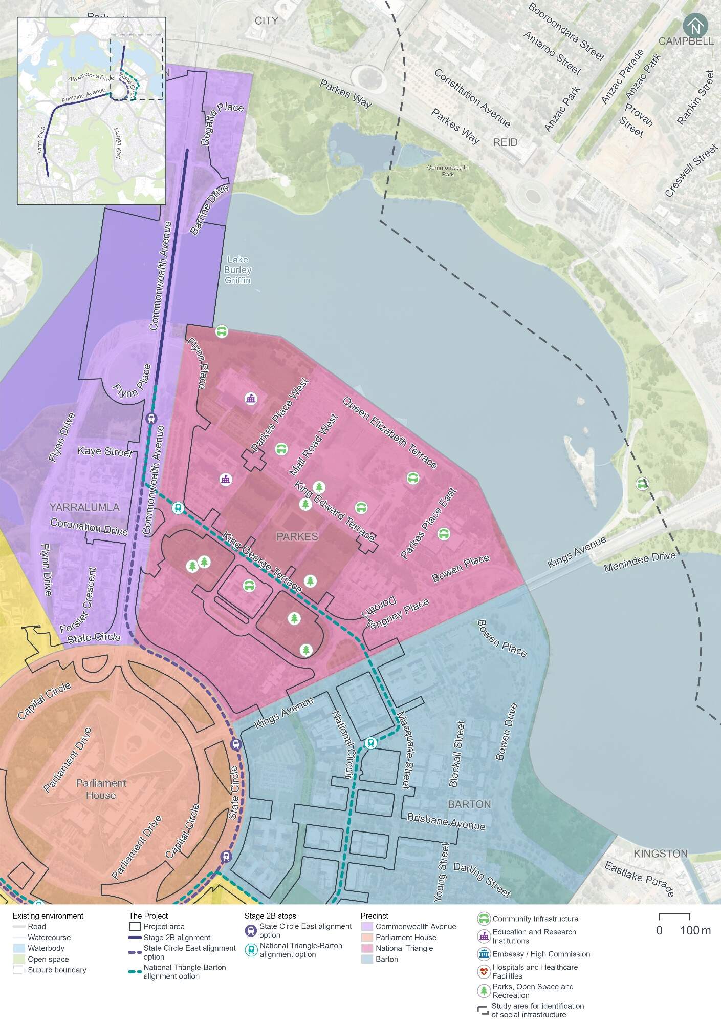
14.7.2 Potential impacts - construction
A summary of the potential socioeconomic impacts of the Project's construction for those working in, visiting, or living in proximity to the National Triangle precinct is provided in Table 14-30.
The significance of each impact has been evaluated taking into account its likelihood and magnitude, both before and after the implementation of proposed mitigation measures. The assessment approach is described further in Chapter 10 (Assessment methodologies) and Section 4 of Technical Report 6 - Socioeconomic.
The people most likely to be affected by change in this precinct would include workers in the precinct and key sensitive receivers such as occupants of the Aboriginal Tent Embassy.
During consultation activities (described in Chapter 4 (Stakeholder and community consultation)), feedback collected from stakeholders within this precinct indicated concern with potential construction noise and vibration and construction traffic impacting workers, visitors, and events. Stakeholder consultation with cultural institutions and major employers in the precinct indicated availability of parking to be of importance to workers and visitors.
Although some construction impacts remain rated as medium even after mitigation, impacts are predominantly temporary and would be minimised through the implementation of the mitigation measures identified in Table 14-30 and Chapter 21 (Environmental management and mitigation measures).
| Description of impact | Relevant alignment option | Pre-mitigation impact (likelihood/ magnitude) | Mitigation approach | Mitigated impact (likelihood/ magnitude) |
|---|---|---|---|---|
|
Health and wellbeing Disruptions to local amenity during construction, potentially leading to a decline in health and wellbeing affecting visitors to public buildings and recreation areas. This may particularly affect people with disabilities or chronic illnesses. Changes to local amenity to this precinct are assessed further in Section 14.1.4, Section 14.3, and Section 14.6 (in relation to traffic, noise and visual impacts, respectively). |
Both |
High |
|
Medium |
|
Disruptions to the road network and parking - impacts to road users Temporary impact to road users on existing road network during construction due to temporary traffic changes which may impact travel times, including during major events. This would include substantial temporary loss of on-street parking spaces (including on King George Terrace, Langton Crescent, Parkes Place West, Parkes Place East, Parliament Square, and Queen Victoria Terrace), impact to bus zones on King George Terrace and several road closures, which would change how people travel through and use the area. Further detail on transport and access impacts within this precinct is provided in Section 14.1.4 . |
National Triangle-Barton alignment option |
High |
|
Medium |
|
Disruptions to the road network and parking - impacts to road users Temporary impact to road users on existing road network during construction due to temporary traffic changes which may impact travel times, including during major events. This would include some limited temporary loss of off-street parking spaces in the Queen Victoria Terrace car park and some nearby on-street parking spaces on Queen Victoria Terrace, which would change how people travel through and use the area. |
State Circle East alignment option |
Medium |
Low |
|
|
Further detail on transport and access impacts within this precinct is provided in Section 14.1.4 . |
|
|||
|
Economic impacts and disruption to events and cultural festivals Potential for disruption to festivals, exhibitions, and events due to adjacent construction activities and traffic changes, resulting in convergence for attendees, and potentially lower attendance. |
Both |
Very high |
|
Medium |
|
Visual landscape and heritage Changes to the aesthetic value of the area and impact to heritage items of significance adjacent to construction activities, affecting connection to place, shared histories, and the future of their community, including the Commonwealth Heritage Listed Aboriginal Tent Embassy. Further detail on impacts to heritage in this precinct is provided in Section 14.5 and Section 11.4 of Chapter 11 (Project-wide issues). |
Both |
High |
|
Medium |
14.7.3 Potential impacts - operation
A summary of the potential socioeconomic impacts of operation of the Project for those living, working in or visiting the National Triangle precinct is provided in Table 14-31.
Table 14-31 identifies socioeconomic impacts and evaluates the likelihood and magnitude of these impacts before and after the implementation of proposed mitigation measures. Where the impact is beneficial, this has been noted in Table 14-31. For beneficial impacts, measures which would enhance Project benefits have also been considered. The assessment approach is described further in Chapter 10 (Assessment methodologies) and Section 4 of Technical Report 6 - Socioeconomic.
During engagement activities (refer to Chapter 4 (Stakeholder and community consultation)), some stakeholders emphasised the benefits of light rail operations within the precinct. Stakeholders suggested that enhanced connectivity and transport options could increase visitor numbers for galleries, museums, and events in the area. Transport-related socioeconomic benefits would apply to people across the light rail corridor and are considered further in Chapter 11 (Project-wide issues).
| Description of impact | Relevant alignment option | Pre-mitigation impact (likelihood/ magnitude) | Mitigation approach | Mitigated impact (likelihood/ magnitude) |
|---|---|---|---|---|
|
Landscape and visual changes Changes to community character due to permanent changes to local visual landscape. While there would be the addition of light rail infrastructure, including a light rail stop, and transient LRVs along King George Terrace, there would be an overall increase in the amount of green space resulting in a beneficial impact. Changes to the landscape and visual environment in this precinct are detailed in Section 14.6. |
National Triangle-Barton alignment option |
Beneficial |
|
Beneficial |
|
Heritage and culture The Project is expected to enhance access to significant heritage sites, including the National Heritage Listed Aboriginal Tent Embassy. This improved accessibility could strengthen the connection to place and support the preservation and celebration of shared histories. Further detail on impacts to heritage in this precinct is provided in Section 14.5. |
National Triangle-Barton alignment option |
Beneficial |
|
Beneficial |
|
Access and mobility Enhanced accessibility and safety for pedestrians and cyclists, including those with mobility constraints, through safety-related changes to active travel (e.g. raised intersections). Refer to Section 5.8 of Chapter 5 (Project description) for further detail on active travel arrangements. |
National Triangle-Barton alignment option |
Beneficial |
|
Beneficial |
|
Disruptions to the road network and parking Some decline in accessibility to businesses and services due to permanent loss of around 30 on-street parking spaces on King George Terrace, Parkes Place West and Parkes Place East, and changes to pedestrian and motorist access. Impacts to road networks and parking are detailed in Section 14.1.4. |
National Triangle-Barton alignment option |
Low |
|
Very low |
14.7.4 Precinct-specific management and mitigation measures
Environmental management for this Project is detailed in Chapter 21 (Environmental management and mitigation measures). This includes construction and operational mitigation measures to socioeconomic impacts, that are applicable to the Project as a whole.
No further precinct-specific measures have been identified for socioeconomic impacts within the National Triangle precinct.