Environmental Impact Statement Chapter 16.0 Inner South precinct
Table of contents
Accessibility
This digital version of the EIS is designed to be accessible to all users, providing screen reader compatibility, keyboard navigation, and described images. If you require additional assistance or have specific accessibility needs, please contact us at lightrailtowoden@act.gov.au or call 1800 956 409.
16.0 Inner South precinct
This chapter provides an assessment of potential impacts during operation and construction that relate to the Inner South precinct and identifies mitigation measures to address these impacts. Environmental issues assessed in this chapter include:
- Traffic and transport (Section 16.1.2)
- Noise and vibration (Section 16.3)
- Biodiversity (Section 16.4)
- Historic heritage (Section 16.5)
- Landscape character and visual amenity (Section 16.6)
- Socioeconomic impacts (Section 16.7).
The assessment of some aspects of traffic and transport, biodiversity, historic heritage, and socioeconomic impacts are applicable to the Project as a whole. These aspects have also been assessed in Chapter 11 (Project-wide issues).
Some additional environmental issues relevant to this precinct have been considered at a Project-wide level only in Chapter 11 (Project-wide issues), as the potential impacts and management approach associated with the issue are applicable to the Project as a whole.
16.1 Overview
The Inner South precinct comprises the extent of Adelaide Avenue, generally between the intersection of Adelaide Avenue and National Circuit and the Cotter Road on- and off-ramps just west of Kent Street. Adelaide Avenue is lined with embassies and The Lodge, home of Australia's Prime Minister.
The Project within this precinct would be consistent for both alignment options. The light rail alignment within this precinct would be within the median along Adelaide Avenue. The precinct would also include new light rail bridges between the existing Adelaide Avenue eastbound and westbound carriageways over Hopetoun Circuit.
The precinct would include two grade separated stops located in the median of Adelaide Avenue - Hopetoun Circuit Stop and Kent Street Stop. The Hopetoun Circuit Stop would be located immediately to the west of Hopetoun Circuit, and the Kent Street Stop would be located immediately to the east of Kent Street overbridge.
At the Hopetoun Circuit Stop, the light rail would transition from wire-free running to use of over-head wiring. Over-head wiring would be adopted from this location through to the Woden Interchange.
The precinct would also include a traction power substation (TPS 8), located off Guilfoyle Street within an existing grassed area.
Key Project features within the Inner South precinct are shown in Figure 16-1. Refer to Chapter 5 (Project description) for a more detailed description of the Project within this precinct.
16.1.1 Key construction activities
Construction activities required within this precinct would be generally similar to those required across other precincts. Construction activities are considered at a Project-wide level within Chapter 6 (Construction).
Key construction activities within the Inner South precinct would include:
- Construction of light rail bridges over Hopetoun Circuit between the existing Adelaide Avenue eastbound and westbound carriageways (as described in Section 6.3.4)
- Construction of the TPS off Guilfoyle Street (as described in Section 6.3.8).
There would be no construction compounds within the Inner South precinct.
16.1.2 Environmental impact overview - construction
Key impacts within the Inner South precinct from the construction of the Project are summarised below, and assessed in further detail in this precinct-based assessment chapter.
Traffic and transport
Construction of the Project in the Inner South precinct would be undertaken within and adjacent to the road reserve, and as such would result in the loss of 62 on-street kerbside parking spaces and one bus zone. The loss of these spaces is likely to be staged, so temporary loss of on-street kerbside spaces across the precinct may be less at any given time during the construction program. Broader road network impacts are assessed in Chapter 11 (Project-wide issues).
Activity- and site-specific traffic management measures would be developed and implemented through the Construction Environmental Management Plan(s) for the Project, with a focus on managing construction-related traffic and site access, parking availability, and the adequate performance of the road network in proximity to construction site accesses and haulage routes. Notwithstanding, construction would result in residual traffic impacts following the implementation of these measures. Construction planning would continue with the aim of minimising disruption to the road and transport networks.
Noise and vibration
Construction activities, including earthworks, road works, decommissioning of utilities, construction of stops and construction of bridges on land, are expected to generate noise that could moderately to highly affect nearby residential and non-residential buildings during the day and night, particularly during 'peak' construction scenarios, which represent the noisiest works requiring the use of noise-intensive equipment such as concrete saws and rock breakers. During the night-time hours, a number of sensitive residential receivers are predicted to experience noise levels exceeding the awakening reaction levels, when no mitigations are in place.
Mitigation measures that would be implemented to manage these impacts, such as scheduling to minimise high-noise activities outside of standard construction hours, are expected to reduce the identified potential impacts. Works outside of standard hours would also require assessment and approval on a case-by-case basis. Despite these measures, some temporary disturbances are anticipated, but they are expected to be minimised through effective construction planning and community consultation.
Biodiversity
The Project design has been developed with the aim of avoiding direct and indirect impacts to Matters of National Environmental Significance (MNES) and other biodiversity values in the landscape by minimising the construction footprint. Despite this, some clearing of native vegetation and habitat for species protected under the Environment Protection and Biodiversity Conservation Act 1999 (Cth) (EPBC Act) and the Nature Conservation Act 2014 (ACT) (NC Act) would be required to construct and operate the Project. This would include a total of 3.02 hectares of vegetation within the Inner South precinct, 0.41 hectares of which is characterised as native. Removal of this vegetation would impact suitable habitat for the Golden Sun Moth (Synemon plana) (listed as vulnerable under the EPBC Act and NC Act), foraging habitat for the Gang-gang Cockatoo (Callocephalon fimbriatum) (endangered under the EPBC Act and NC Act) and Superb Parrot (Polytelis swainsonii) (vulnerable under the EPBC Act and NC Act), and foraging and breeding habitat for the Diamond Firetail (Stagonopleura guttata) (vulnerable under the EPBC Act and NC Act). A total of 19 mature native trees, which provide suitable breeding and/or foraging habitat for woodland birds, have also been identified in the proposed clearance footprint within the Inner South precinct.
Opportunities to further avoid or minimise biodiversity impacts, and to enhance habitat and connectivity through Project landscaping would be considered through ongoing design development. A Biodiversity Offset Strategy has been developed for the Project to manage residual impacts which are unable to be avoided, and would be updated to reflect any further avoidance or minimisation of biodiversity impacts achieved through ongoing design development.
Other impacts
Other potential construction environmental impacts identified in this precinct-based assessment chapter are outlined below:
- Historic heritage: The Lodge (listed on the Commonwealth Heritage List) is the only heritage item in the Inner South precinct. No direct impacts as a result of the Project would be experienced, however The Lodge has the potential to be indirectly affected by the Project during construction through vibration caused by construction activities. These impacts would be avoided through appropriate equipment selection, identification, and determination and monitoring of safe vibration levels
- Landscape character and visual amenity: Construction activities, such as the establishment of construction compounds and the use of large-scale equipment, would be visually prominent and may temporarily disrupt the visual amenity of the area. Night-time construction work, where necessary, would also involve lighting that could impact nearby residential properties, particularly near construction activities around the Hopetoun Circuit stop. Works on Hopetoun Circuit would be more prominent in the landscape due to the road corridor sitting above the surrounding landscaping, and would be visible from key locations such as Parliament House and the Telstra Tower on Black Mountain. Mitigation measures, such as high-quality construction hoarding, planting of mature trees to provide some visual buffering, efforts to minimise light spill, and preparation of a visual impact (including light spill) management plan, would be implemented to manage these impacts and maintain the area's visual integrity
- Socioeconomic: Potential impacts include disruptions to local amenity, disruptions to the local road network and parking, and adverse impacts to health and wellbeing due to noise, vibration, and visual impacts, which may particularly affect workers, visitors, and accommodation providers in the area. Mitigation measures, such as the implementation of Construction Environmental Management Plan(s), proactive communication strategies, and public awareness campaigns, would be implemented to minimise these impacts.
Environmental management and mitigation measures proposed to address the specific impacts of the Project within this precinct are detailed in Chapter 21 (Environmental management and mitigation measures).
For construction related impacts, a Construction Environmental Management Plan(s) (CEMP) would be prepared as a framework for environmental management, including several sub plans (such as a noise and vibration and traffic and transport management plans) and mitigation measures. An Environmental Management Plan outline (addressing construction and operational aspects) has been developed for the Project to guide the development of the CEMP(s) and sub plans, and is included as Appendix L (Environmental Management Plan outline).
16.1.3 Environmental impact overview - operation
Key impacts within the Inner South precinct during the operational stage of the Project are summarised below, and assessed in further detail throughout this precinct-based assessment chapter.
Traffic and transport
The operational phase of the Project in the Inner South precinct would require several changes to the road network, including adjustments to existing lanes, key intersections and access arrangements to accommodate the light rail infrastructure. Irrespective of the alignment option, the Project would include signalisation of the Adelaide Avenue on/off ramp intersections with Hopetoun Circuit, which would result in substantial decreases in delays in the AM peak hour. Additionally, there would be a permanent loss of three kerbside car spaces along Hopetoun Circuit.
Further design development and management measures would be implemented to address these changes, such as public awareness campaigns to increase understanding of new arrangements and interactions between cars, bicycles, and pedestrians with light rail during operation, and review of options to further optimise the interface between different transport modes. Other operational impacts have been assessed on a Project-wide basis, where relevant, in Section 11.2.2 of Chapter 11 (Project-wide issues).
Other impacts
Other operational environmental impacts identified in this precinct-based assessment chapter are outlined below:
- Landscape character and visual amenity: The introduction of light rail infrastructure, including tracks, stops, and over-head wiring, would result in permanent changes to the landscape character and visual amenity of the area. Moderate adverse visual impacts are predicted within Inner South precinct. The Public Domain Master Plan (Appendix I) identifies design principles and guidance for the Project. As identified in mitigation measure LV1 in Chapter 21 (Environmental management and mitigation measures), these principles would be applied to the Project through ongoing design development and would contribute to the management and mitigation of landscape and visual impacts of the Project during operation
- Biodiversity: In addition to direct biodiversity impacts associated with clearing of native vegetation and habitat of protected species (as described in Section 16.1.2), native vegetation and habitat adjacent to the clearance footprint, and species using air space above the Project have the potential to experience indirect impacts from the operation of the Project. This could include the potential risk of fauna strike from light rail vehicles (LRVs) or over-head wiring. Proposed mitigation measures include strategies to minimise fauna strike through effective landscape design
- Socioeconomic: Benefits of the Project within the Inner South precinct include provision of an alternative to private vehicle use, which can enhance accessibility and, over time, reduce potential traffic congestion. Adverse socioeconomic impacts may also arise, most notably from operational noise, disrupting social amenity, and providing additional noise at places of worship and educational facilities. Continued implementation of design principles and guidance documented in the Public Domain Master Plan would support the design of high quality and manage these potential impacts
- Noise and vibration: Operation of the Project would result in limited noise and vibration impacts within the precinct, with noise and vibration levels predicted to comply with relevant criteria at most receivers. Some minor exceedances of criteria for airborne and ground-borne noise are predicted at receivers closest to the alignment, such as buildings associated with Canberra Girls Grammar School and the Canberra House of Prayer. The Project would be designed and operated to minimise operational noise and vibration impacts on sensitive receivers, predominantly through consideration of track design measures and operational maintenance planning. These measures would enable residual impacts to be limited
- Historic heritage: No direct impacts to heritage places within this precinct are predicted during the operation of the Project. The Lodge (listed on the Commonwealth Heritage Register) has the potential to experience indirect impacts due to plantings on the median of Adelaide Avenue partially impeding views to and from The Lodge, however, these changes would not detract from the place's heritage value and visual prominence.
Environmental management and mitigation measures proposed to address the specific impacts of the Project within this precinct are detailed in Chapter 21 (Environmental management and mitigation measures). An Operational Environmental Management Plan (OEMP) with supporting sub plans would be implemented as a framework for environmental management during operation. An Environmental Management Plan outline has been developed for the Project to guide the development of the OEMP, and is included as Appendix L (Environmental Management Plan outline).
16.2 Traffic and transport
This section provides a summarised assessment of the potential multimodal traffic and transport impacts associated with the construction and operation phases of the Project within the Inner South precinct. Further detail on the traffic and transport impact assessment is provided in Technical Report 1 - Traffic and transport. The methodology applied for this assessment is summarised in Chapter 10 (Assessment methodologies) and discussed in detail in Section 3 of Technical Report 1 - Traffic and transport. Impacts to traffic and transport for the Project as a whole are discussed in Section 11.1 of Chapter 11 (Project-wide issues).
16.2.1 Existing environment
This section provides an overview of the existing traffic and transport features within the Project area. To understand the existing environment relevant to traffic and transport, the following have been considered: the transport network, road network, traffic volumes, intersection performance, public and active transport, carparking (including kerbside uses and access), and crash history.
Transport network
The study area for this assessment is based on the Project area with an additional buffer to incorporate the surrounding road network (the precinct study area). The existing transport network within the Inner South precinct and the respective study area is indicatively shown in Figure 16-2.
Road network
The characteristics and features of key roads within the Inner South precinct are summarised in Table 16-1.
| Road | Classification | Direction | Configuration | Speed limit1 |
|---|---|---|---|---|
|
Adelaide Avenue |
Arterial |
Two-way |
Three lanes in each direction |
80 km/h |
|
Hopetoun Circuit |
Major collector |
Two-way |
One lane in each direction |
60 km/h |
|
National Circuit |
Two-way |
One lane in each direction |
50 km/h |
|
|
Empire Circuit |
Two-way |
One lane in each direction |
50 km/h |
|
|
Kent Street |
Two-way |
Two lanes in each direction along Adelaide Avenue overpass. One lane in each direction on either side of overpass |
60 km/h |
|
|
Novar Street |
Two-way |
One lane in each direction |
60 km/h |
Notes:
- Where no speed limit was signposted, the speed limit was assumed to be 50 km/h, the default speed limit for a built-up area.
Traffic volumes
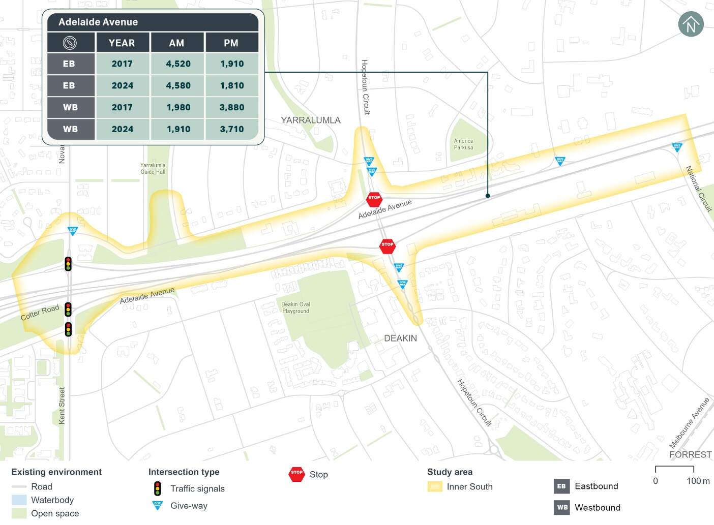
Existing 2024 and historical 2017 weekday AM (8:00am to 9:00am) and PM (5:00pm to 6:00pm) peak hour traffic counts for various mid-block locations within the Inner South precinct have been analysed and are summarised in Figure 16-3. The 2024 data indicates that traffic volumes along Adelaide Avenue are similar in 2017 and 2024, during the AM and PM peak hours.
Historical average weekday traffic volume, heavy vehicle composition and 85th percentile speed data have also been analysed for key roads within the Inner South precinct, with a summary provided in Table 16-2. The data indicates that heavy vehicles account for around 3% to 4% of the total daily traffic volumes on the key roads through the precinct. Adelaide Avenue's 85th percentile vehicle speed is also slightly higher than the posted speed limit.
| Road | Location | Date of available data | Average weekday traffic volume (vehicles per day) | Heavy vehicle % | 85th percentile speed |
|---|---|---|---|---|---|
|
Adelaide Avenue |
Between Hopetoun Circuit and Kent Street |
2023 |
49,950 |
3% |
83 km/h |
|
Hopetoun Circuit |
Between Grey Street and Grose Crescent |
2016 |
11,360 |
4% |
56 km/h |
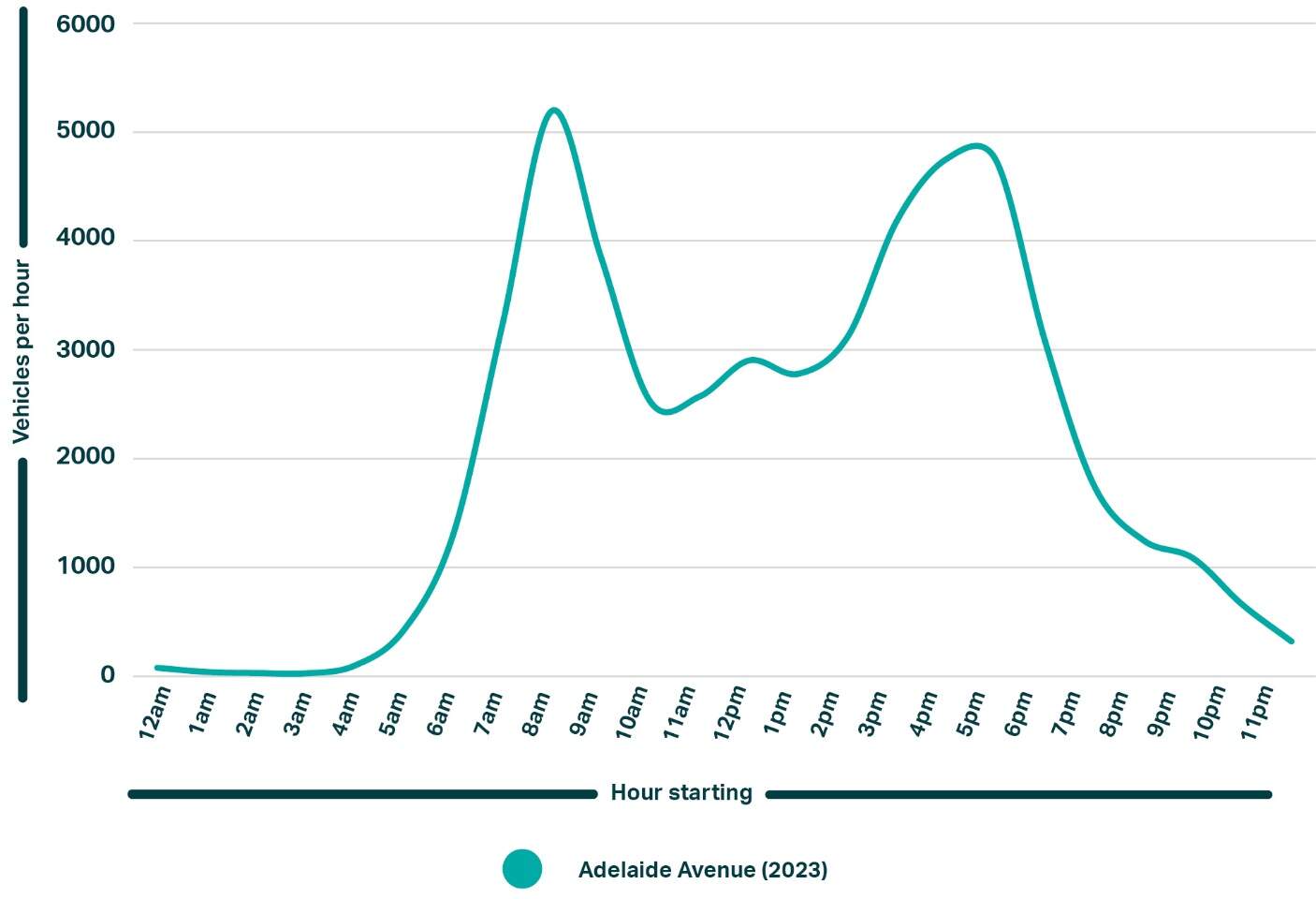
The weekday average daily traffic volume profile for Adelaide Avenue (refer to Figure 16-4), which indicates a clear AM peak hour between 8:00 am and 9:00 am and a PM peak hour between 5:00 pm and 6:00 pm. Traffic volumes on Adelaide Avenue are typically much lower during off-peak periods.
Intersection performance
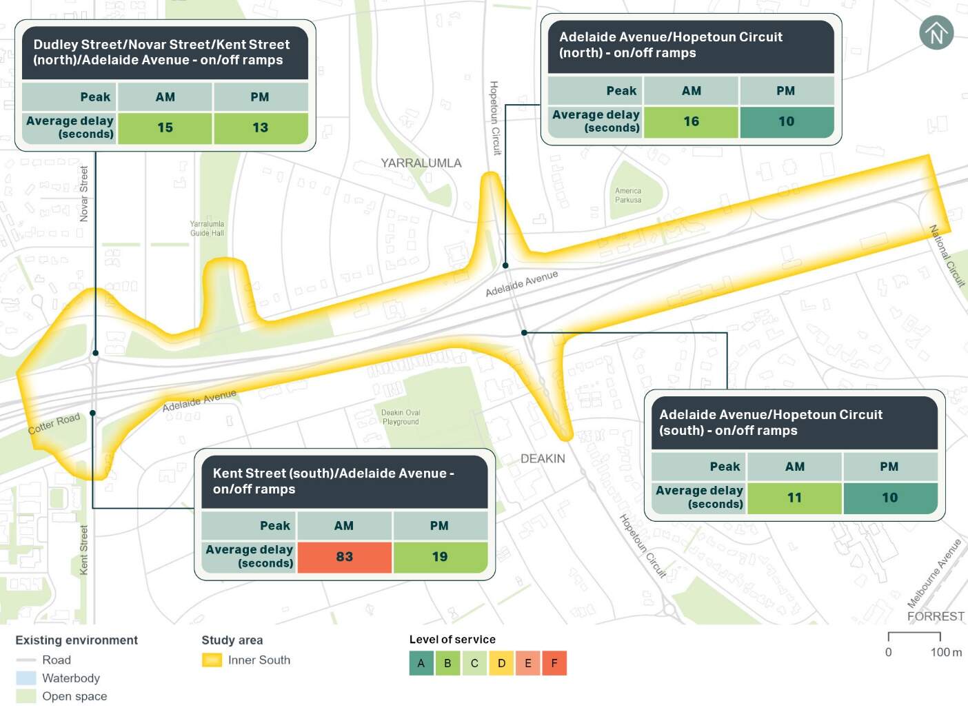
The operation of the key intersections within the Inner South precinct has been assessed using the microsimulation model which has been calibrated to 2017 traffic conditions and data, as discussed in Chapter 10 (Assessment methodologies). The 2017 intersection performance within the precinct existing performance of the assessed intersections is shown in Figure 16-5.
The Adelaide Avenue/Kent Street (south) intersection operated at a level of service F in the AM peak hour in 2017. Level of service represents the extent of delays experienced by drivers at an intersection. It is noted that this intersection is unsignalised and instead priority-controlled in 2017, with the high vehicle delay associated with vehicles trying to find gaps in traffic when turning onto Kent Street from the Adelaide Avenue off-ramp. This intersection has since been upgraded and is now signalised. All other intersections operated satisfactorily at a level of service B or better during the weekday peak hours.
Current observations in June 2024 indicate there are some short periods of congestion on Hopetoun Circuit at the intersections with the Adelaide Avenue on/off-ramps during the AM and PM peak hours. This would reduce the ability for vehicles to turn onto Hopetoun Circuit from the on/off-ramps.
Public transport
No bus stops are located along Adelaide Avenue within the Inner South precinct. However, there are bus stops on Kent Street and Hopetoun Circuit immediately adjacent to the precinct. These bus stops serve the 57 bus route operated by Transport Canberra, offering connections between the Woden Interchange and the City Interchange.
Multiple bus routes use Adelaide Avenue. However, these buses do not stop within the Inner South precinct. Dedicated T2 transit lanes on Adelaide Avenue within the precinct can only be used by buses and other permitted vehicles.
Active transport
Footpaths adjacent to Adelaide Avenue are throughout the Inner South precinct, typically measuring less than 1.5 m wide. Most connecting side roads, including Empire Circuit, Hopetoun Circuit, Kent Street and Novar Street, feature footpaths on both sides.
Crossing points across Adelaide Avenue are limited to overpasses or underpasses at Kent Street and Hopetoun Circuit. Beyond Adelaide Avenue, signalised pedestrian crossings are at the following intersections:
- Kent Street/Novar Street/Dudley Street on the north and east approaches
- Kent Street/Adelaide Avenue off-ramp on the east and south approaches.
On-road cycle lanes are on both sides of Adelaide Avenue. These cycle lanes cross on-ramps and off-ramps along Adelaide Avenue at multiple locations.
The City to Tuggeranong via Woden principal cycle route runs along the east side of the Kent Street overpass over Adelaide Avenue through the precinct. As identified in the Active Travel Plan 2024-2030 (ACT Government, 2024), an extension of this principal cycle route along Adelaide Avenue between State Circle and Kent Street is currently being considered to provide an alternative to the existing on-road cycle lanes. In addition, a future network cycling link is also planned on Hopetoun Circuit.
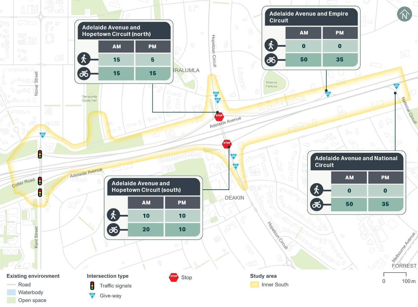
Pedestrian and cyclist count data from 2024 has been used to understand current active travel demand within the Inner South precinct. The AM and PM peak hour counts at key locations within the precinct are summarised in Figure 16-6. As shown, around 30 to 50 cyclists have been recorded at the locations shown below in Figure 16-6. Pedestrian and cyclist volumes along Hopetoun Circuit are low, equating to less than 20 people.
Car parking, kerbside uses, and access
Kerbside uses
The existing kerbside uses including on-street parking within the Inner South precinct are summarised in Table 16-3.
| On/off alignment | Road | Between | Side of road | Restriction | Number of existing spaces |
|---|---|---|---|---|---|
|
Off alignment |
Hopetoun Circuit |
Precinct study area boundary and Weston Street |
East |
Unrestricted |
6 |
|
West |
Unrestricted |
7 |
|||
|
Bus zone (public) |
N/A |
||||
|
Weston Street and Adelaide Avenue |
East |
Unrestricted |
3 |
||
|
West |
Unrestricted |
6 |
|||
|
Adelaide Avenue and Grose Street |
East |
Bus zone (public) |
N/A |
||
|
West |
Bus zone (public) |
N/A |
|||
|
2P |
6 |
||||
|
Grose Street and precinct study area boundary |
West |
Taxi zone |
2 |
||
|
1/4P |
3 |
||||
|
Kintore Crescent/ Guilfoyle Street |
Novar Street and Gunn Street |
North |
Unrestricted |
11 |
|
|
South |
Unrestricted |
18 |
|||
|
Denison Street |
Kent Street and Geils Court |
South |
Bus zone |
N/A |
|
|
Total |
62 |
||||
Off-street parking
No off-street parking is located within the Inner South precinct. Further afield and adjacent to the Inner South precinct, a mix of restricted and unrestricted off-street parking is provided for the retail and commercial areas within Deakin.
Property access
There is only one property access within the Inner South precinct, which is a two-way access on Adelaide Avenue at the Lodge.
Crash history
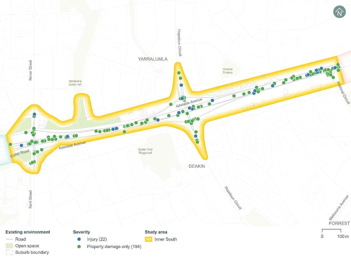
Figure 16-7 shows the five year crash history (1 January 2018 to 31 December 2022) within the Inner South precinct.
A total of 216 crashes have been recorded during the five year period, including:
- One crash that resulted in a serious injury (less than 1%)
- 21 crashes that resulted in a minor injury (around 10%)
- 194 crashes that resulted in property damage only (around 90%).
The following common crash types occurred:
- Around 69% of crashes involved a rear end collision
- Around 11% of crashes involved right angle collision
- Around 11% of crashes involved a same direction side swipe.
Modelling approach
The transport modelling assumptions have adopted the 'committed and funded expenditure approach' as per Infrastructure Australia guidance. This approach was agreed in consultation with Treasury and other key stakeholders including TCCS. The 'committed and funded expenditure approach' requires that only transport projects identified as 'committed and funded' are to be included in the 2031 and 2041 with and without Project scenarios.
As identified in the ACT Infrastructure Plan update - Transport (ACT Government, 2024), project priorities identified beyond the current budget are indicative and may change in response to community preferences, shifts in demand for services and the availability of funding. This means that any projects that might be in planning or may be required to accommodate expected travel demands but have not been identified as 'committed and funded' are not included in the traffic modelling for the Project. This is particularly prevalent in the 2041 scenarios during Project operation.
Based on the transport modelling inputs and assumptions presented above, the transport modelling assesses the impacts of the Project in isolation. It does not consider the broader network benefits that may be realised by the implementation of planned (but not committed and funded) transport infrastructure projects.
By not considering other changes to the transport network, the transport modelling presents an absolute worst-case scenario in relation to the performance of the future road network.
16.2.2 Potential impacts - construction
Potential impacts of the construction of the Project on parking and access within the precinct are summarised in the following sections. Other construction-related impacts have been assessed at a Project-wide basis, where relevant, in Section 11.1.2 of Chapter 11 (Project-wide issues).
Kerbside use
It is estimated that all 62 identified on-street kerbside spaces and one bus zone would be lost within the Inner South precinct, including:
- 33 spaces on Hopetoun Circuit (off-alignment)
- 29 spaces on Kintore Crescent/Guilfoyle Street (off-alignment)
- One bus zone on Denison Street.
Of these kerbside uses, three on-street kerbside spaces along Hopetoun Circuit would be permanently lost as part of the Project's permanent works. The remaining spaces would be temporarily lost during construction. However, construction works are likely to be staged, so the temporary loss of on-street kerbside spaces across the precinct may be less at any given time during the construction program.
Off-street parking
The Project's construction would not change any off-street parking within the Inner South precinct.
Local area access
The Project's construction would not change any local area access arrangements within the Inner South precinct.
Property access
The Project's construction would not change any property accesses within the Inner South precinct.
16.2.3 Potential impacts - operation
Potential operational impacts on the road network, active travel and parking of relevance to the precinct are summarised in the following sections. Other operational impacts have been assessed at a Project-wide basis, where relevant, in Section 11.1.3 of Chapter 11 (Project-wide issues).
Road network changes
The road network changes within the Inner South precinct would include adjustments to existing lanes, key intersection adjustments, and adjustments to access arrangements. Refer to Chapter 5 (Project description) for further discussion on road network changes.
Traffic volumes and patterns
Traffic volumes and patterns have been modelled to compare weekday peak hour changes in traffic flow across the Inner South precinct, particularly on Adelaide Avenue, Hopetoun Circuit, Kent Street/Novar Street and Cotter Road.
2031 and 2041 were adopted as the future years for the traffic modelling. The years 2031 and 2041 were used to represent indicative future scenarios, providing a benchmark for assessing the potential operational impacts of the Project.
The Project would result in traffic reassignment (when traffic is redistributed as drivers choose alternative routes due to changes in the road network) across the broader road network as drivers seek alternative routes to maintain travel times. This results in some differences in traffic volumes between the with and without Project scenarios, even in locations where there would be no road network changes as part of the Project. Although the two alignment options are the same within the Inner South precinct, different travel patterns are also expected throughout the precinct due the different alignment configurations further afield in the Commonwealth Avenue, Parliament House, National Triangle and Barton precincts.
Traffic volume changes caused by the State Circle East alignment option are summarised in Table 16-4 and Table 16-5, and those caused by the National Triangle-Barton alignment option are summarised in Table 16-6 and Table 16-7. These traffic flow changes are due to the following:
- Regional and local traffic reassignment (when traffic is redistributed as drivers choose alternative routes due to changes in the road network) caused by the Project's road network changes and consequent impacts to road network performance, particularly the Project's reduced capacity on State Circle and Adelaide Avenue, caused by lane reductions and the introduction of light rail signal phases and the signalisation of the Hopetoun Circuit interchange intersections
- Changes in mode choice due to the introduction of light rail.
State Circle East alignment option
| Road | Location | Direction | 2031 scenario | 2041 scenario | ||||||
|---|---|---|---|---|---|---|---|---|---|---|
| Without Project | With Project | Difference | Without Project | With Project | Difference | |||||
|
Adelaide Avenue |
Between Hopetoun Circuit and Empire Circuit |
Eastbound |
4,590 |
4,280 |
-310 |
-7% |
4,030 |
4,220 |
190 |
5% |
|
Westbound |
2,570 |
2,260 |
-310 |
-12% |
2,710 |
2,330 |
-380 |
-14% |
||
|
Hopetoun Circuit |
Below Adelaide Avenue |
Northbound |
590 |
570 |
-20 |
-3% |
590 |
560 |
-30 |
-5% |
|
Southbound |
1,460 |
1,270 |
-190 |
-13% |
1,430 |
1,250 |
-180 |
-13% |
||
|
Kent Street |
Above Adelaide Avenue |
Northbound |
690 |
790 |
100 |
14% |
750 |
820 |
70 |
9% |
|
Southbound |
600 |
670 |
70 |
12% |
520 |
750 |
230 |
44% |
||
| Road | Location | Direction | 2031 scenario | 2041 scenario | ||||||
|---|---|---|---|---|---|---|---|---|---|---|
| Without Project | With Project | Difference | Without Project | With Project | Difference | |||||
|
Adelaide Avenue |
Between Hopetoun Circuit and Empire Circuit |
Eastbound |
2,210 |
2,030 |
-180 |
-8% |
2,620 |
2,260 |
-360 |
-14% |
|
Westbound |
3,860 |
3,920 |
60 |
2% |
3,760 |
3,630 |
-130 |
-3% |
||
|
Hopetoun Circuit |
Below Adelaide Avenue |
Northbound |
630 |
540 |
-90 |
-14% |
580 |
480 |
-100 |
-17% |
|
Southbound |
790 |
780 |
-10 |
-1% |
840 |
1,020 |
180 |
21% |
||
|
Kent Street |
Above Adelaide Avenue |
Northbound |
1,430 |
1,320 |
-110 |
-8% |
1,330 |
1,360 |
30 |
2% |
|
Southbound |
360 |
370 |
10 |
3% |
370 |
470 |
100 |
27% |
||
National Triangle-Barton alignment option
| Road | Location | Direction | 2031 scenario | 2041 scenario | ||||||
|---|---|---|---|---|---|---|---|---|---|---|
| Without Project | With Project | Difference | Without Project | With Project | Difference | |||||
|
Adelaide Avenue |
Between Hopetoun Circuit and Empire Circuit |
Eastbound |
4,590 |
4,270 |
-320 |
-7% |
4,030 |
3,910 |
-120 |
-3% |
|
Westbound |
2,570 |
2,480 |
-90 |
-4% |
2,710 |
2,310 |
-400 |
-15% |
||
|
Hopetoun Circuit |
Below Adelaide Avenue |
Northbound |
590 |
640 |
50 |
8% |
590 |
590 |
0 |
0% |
|
Southbound |
1,460 |
1,220 |
-240 |
-16% |
1,430 |
1,280 |
-150 |
-10% |
||
|
Kent Street |
Above Adelaide Avenue |
Northbound |
690 |
710 |
20 |
3% |
750 |
760 |
10 |
1% |
|
Southbound |
600 |
610 |
10 |
2% |
520 |
660 |
140 |
27% |
||
| Road | Location | Direction | 2031 scenario | 2041 scenario | ||||||
|---|---|---|---|---|---|---|---|---|---|---|
| Without Project | With Project | Difference | Without Project | With Project | Difference | |||||
|
Adelaide Avenue |
Between Hopetoun Circuit and Empire Circuit |
Eastbound |
2,210 |
2,230 |
20 |
1% |
2,620 |
2,410 |
-210 |
-8% |
|
Westbound |
3,860 |
3,970 |
110 |
3% |
3,760 |
3,920 |
160 |
4% |
||
|
Hopetoun Circuit |
Below Adelaide Avenue |
Northbound |
630 |
610 |
-20 |
-3% |
580 |
590 |
10 |
2% |
|
Southbound |
790 |
700 |
-90 |
-11% |
840 |
840 |
0 |
0% |
||
|
Kent Street |
Above Adelaide Avenue |
Northbound |
1,430 |
1,480 |
50 |
3% |
1,330 |
1,470 |
140 |
11% |
|
Southbound |
360 |
450 |
90 |
25% |
370 |
480 |
110 |
30% |
||
Road network performance
The Project's impacts on the road network in the Inner South precinct are primarily confined to the longitudinal corridor along Adelaide Avenue and its closely spaced interchanges with Hopetoun Circuit and Kent Street/Novar Street.
AM peak hour
During the AM peak hour in 2031 and 2041, the eastbound off-ramp from Adelaide Avenue to the unsignalised intersection with Hopetoun Circuit would experience lengthy delays and high levels of congestion without the Project due to the increased vehicle flows along Hopetoun Circuit. These delays would cause vehicle queuing to extend onto Adelaide Avenue and back to Cotter Road and the Carruthers Street interchange. The vehicle queuing blocks the on-ramp from Kent Street/Novar Street which would cause congestion and vehicle delays along Kent Street/Novar Street and at its intersections.
The Project, irrespective of the alignment option, would include signalisation of the Adelaide Avenue on/off ramp intersections with Hopetoun Circuit. As a result, vehicle delays during the AM peak hour in both 2031 and 2041 scenarios would decrease substantially with the Project, particularly eastbound along Adelaide Avenue and on the off-ramp to Hopetoun Circuit.
PM peak hour
During the PM peak hour in 2031 and 2041, the westbound off-ramp from Adelaide Avenue to the unsignalised intersection with Hopetoun Circuit would experience lengthy delays without the Project due to increased vehicle flows along Hopetoun Circuit.
The Project's changes to the Inner South precinct's road network and associated traffic reassignment (irrespective of the alignment option) would cause the following changes to congestion and delay when compared to the without Project scenario in 2031 and 2041 in the PM peak hour:
- Increased congestion and delay on Adelaide Avenue in the westbound direction between National Circuit and the Hopetoun Circuit interchange due to the reduced number of lanes on Adelaide Avenue
- Increased congestion and delay on National Circuit due to insufficient gaps in the westbound traffic stream on Adelaide Avenue.
Intersection performance
State Circle East alignment option
The performance of the key intersections within the Inner South precinct with and without the Project for the State Circle East alignment option is provided in Table 16-8 and Table 16-9. Intersection performance is evaluated using the level of service and average delay assessed for each intersection. Level of service represents the extent of delays experienced by drivers at an intersection. Further detail on intersection performance can be found in Technical Report 1 - Traffic and transport. Key findings relating to intersection performance are as follows:
AM peak hour:
- The assessed intersections would generally operate satisfactorily at a level of service D or better with the Project in 2031 and 2041 scenarios. The exception is the Dudley Street/Novar Street/Kent Street intersection which would operate at a level of service E in the 2031 scenario, although noting it would be on the boundary of level of service D and E
- All intersections generally operate better with the Project compared to without the Project. On Hopetoun Circuit, this is primarily a result of the signalisation of the Adelaide Avenue on/off ramp intersections. The signalisation of the Hopetoun Circuit intersections would also reduce eastbound queuing on Adelaide Avenue, which has a flow-on impact of improving the performance of the Dudley Street/Novar Street/Kent Street (north).
PM peak hour:
- The assessed intersections would generally operate satisfactorily at a level of service D or better with the Project in 2031 and 2041 scenarios
- Similar to the AM peak hour, most intersections operate better with the Project compared to without the Project. This is primarily as a result of the signalisation of the Adelaide Avenue on/off ramp intersections and its flow on impacts.
| Intersection | 2031 scenario | 2041 scenario | ||||||
|---|---|---|---|---|---|---|---|---|
| Without Project | With Project | Without Project | With Project | |||||
|
Average delay (seconds) |
Level of service |
Average delay (seconds) |
Level of service |
Average delay (seconds) |
Level of service |
Average delay (seconds) |
Level of service |
|
|
Adelaide Avenue/ Hopetoun Circuit (north) - on/off ramps |
>150 |
F |
51 |
D |
>150 |
F |
51 |
D |
|
Adelaide Avenue/ Hopetoun Circuit (south) - on/off ramps |
18 |
B |
15 |
B |
28 |
C |
17 |
B |
|
Dudley Street/ Novar Street/Kent Street (north)/ Adelaide Avenue - on/off ramps |
>150 |
F |
56 |
E |
>150 |
F |
53 |
D |
|
Kent Street (south)/Adelaide Avenue - on/off ramps |
82 |
F |
41 |
D |
115 |
F |
41 |
D |
Note: As discussed in Technical Report 1 - Traffic and transport, separate VISSIM microsimulation models have been used to assess the State Circle East and National Triangle-Barton alignment options which may result in small intersection performance differences between the without Project scenarios for each alignment option.
| Intersection | 2031 scenario | 2041 scenario | ||||||
|---|---|---|---|---|---|---|---|---|
| Without Project | With Project | Without Project | With Project | |||||
|
Average delay (seconds) |
Level of service |
Average delay (seconds) |
Level of service |
Average delay (seconds) |
Level of service |
Average delay (seconds) |
Level of service |
|
|
Adelaide Avenue/ Hopetoun Circuit (north) - on/off ramps |
19 |
B |
40 |
D |
16 |
B |
40 |
D |
|
Adelaide Avenue/ Hopetoun Circuit (south) - on/off ramps |
>150 |
F |
33 |
C |
>150 |
F |
28 |
C |
|
Dudley Street/ Novar Street/Kent Street (north)/ Adelaide Avenue - on/off ramps |
35 |
C |
29 |
C |
44 |
D |
31 |
C |
|
Kent Street (south)/Adelaide Avenue - on/off ramps |
20 |
B |
21 |
C |
25 |
C |
26 |
C |
Note: As discussed in Technical Report 1 - Traffic and transport, separate VISSIM microsimulation models have been used to assess the State Circle East and National Triangle-Barton alignment options which may result in small intersection performance differences between the without Project scenarios for each alignment option.
National Triangle-Barton alignment option
The performance of the key intersections within the Inner South precinct with and without the Project for the National Triangle-Barton alignment option is provided in Table 16-10 and Table 16-11. Key findings relating to intersection performance are as follows:
AM peak hour:
- The following intersections would generally operate satisfactorily at a level of service D or better with the Project in 2031 and 2041 scenarios. The following intersections would generally operate satisfactorily at a level of service D or better with the Project in 2031 and 2041 scenarios:
- Adelaide Avenue/Hopetoun Circuit (north) - on/off ramps
- Adelaide Avenue/Hopetoun Circuit (south) - on/off ramps
- Adelaide Avenue/Kent Street (south) - on/off ramps
- The Dudley Street/Novar Street/Kent Street intersection would operate at a level of service E with the Project in 2031 and 2041 scenarios
- All intersections generally operate better with the Project compared to without the Project. On Hopetoun Circuit, this is primarily a result of the signalisation of the Adelaide Avenue on/off ramp intersections. The signalisation of the Hopetoun Circuit intersections would also reduce eastbound queuing on Adelaide Avenue, which has a flow-on impact of improving the performance of the Dudley Street/Novar Street/Kent Street (north).
PM peak hour:
- The assessed intersections would generally operate satisfactorily at a level of service C or better with the Project in 2031 and 2041 scenarios
- Similar to the AM peak hour, the Adelaide Avenue/Hopetoun Circuit (south) and Dudley Street/Novar Street/Kent Street intersections operate better with the Project compared to without the Project. This is primarily due to the signalisation of the Adelaide Avenue on/off ramp intersections and its flow-on impacts.
| Intersection | 2031 scenario | 2041 scenario | ||||||
|---|---|---|---|---|---|---|---|---|
| Without Project | With Project | Without Project | With Project | |||||
|
Average delay (seconds) |
Level of service |
Average delay (seconds) |
Level of service |
Average delay (seconds) |
Level of service |
Average delay (seconds) |
Level of service |
|
|
Adelaide Avenue/ Hopetoun Circuit (north) - on/off ramps |
>150 |
F |
44 |
D |
>150 |
F |
44 |
D |
|
Adelaide Avenue/ Hopetoun Circuit (south) - on/off ramps |
13 |
B |
17 |
B |
28 |
C |
19 |
B |
|
Dudley Street/ Novar Street/Kent Street (north)/ Adelaide Avenue - on/off ramps |
>150 |
F |
61 |
E |
>150 |
F |
63 |
E |
|
Kent Street (south)/Adelaide Avenue - on/off ramps |
81 |
F |
28 |
C |
119 |
F |
26 |
C |
Note: As discussed in Technical Report 1 - Traffic and transport, separate VISSIM microsimulation models have been used to assess the State Circle East and National Triangle-Barton alignment options which may result in small intersection performance differences between the without Project scenarios for each alignment option.
| Intersection | 2031 scenario | 2041 scenario | ||||||
|---|---|---|---|---|---|---|---|---|
| Without Project | With Project | Without Project | With Project | |||||
|
Average delay (seconds) |
Level of service |
Average delay (seconds) |
Level of service |
Average delay (seconds) |
Level of service |
Average delay (seconds) |
Level of service |
|
|
Adelaide Avenue/ Hopetoun Circuit (north) - on/off ramps |
18 |
B |
33 |
C |
31 |
C |
35 |
C |
|
Adelaide Avenue/ Hopetoun Circuit (south) - on/off ramps |
>150 |
F |
33 |
C |
>150 |
F |
33 |
C |
|
Dudley Street/ Novar Street/Kent Street (north)/ Adelaide Avenue - on/off ramps |
36 |
D |
31 |
C |
42 |
D |
35 |
C |
|
Kent Street (south)/Adelaide Avenue - on/off ramps |
20 |
B |
22 |
C |
23 |
C |
27 |
C |
Note: As discussed in Technical Report 1 - Traffic and transport, separate VISSIM microsimulation models have been used to assess the State Circle East and National Triangle-Barton alignment options which may result in small intersection performance differences between the without Project scenarios for each alignment option.
Active travel
For much of the Project, existing active travel arrangements would be retained and would be complemented by new active travel arrangements or treatments. The key pedestrian and cyclist pathways that would be provided within the Inner South precinct as part of the Project and their benefits or impacts are summarised in Table 16-12.
| Proposed treatment | Impact or benefit |
|---|---|
|
New traffic signals would be provided on the on and off ramp intersections with Hopetoun Circuit. |
The signalised pedestrian crossings would provide a controlled and typically safer crossing facility. However, providing signalised pedestrian crossings could result in higher delays for pedestrians waiting to cross the road. |
|
Existing on-road cycleways on Adelaide Avenue would be retained, however minor modifications would be required at the upgraded intersections located at the on and off ramps with Adelaide Avenue and Hopetoun Circuit. |
The reconfiguration of the Adelaide Avenue on-road cycleways at Hopetoun Circuit would generally not impact the existing level of active travel accessibility. |
|
A new public plaza would be provided on Hopetoun Circuit. |
The plaza would provide improved pedestrian and cyclist amenity and a connection to the Hopetoun Circuit Stop. |
|
The unsignalised crossings on the left turn exits of the Adelaide Avenue off ramps at Kent Street would be signalised to facilitate higher volume pedestrian crossings. |
The signalised pedestrian crossings would provide a controlled and typically safer crossing facility. However, providing signalised pedestrian crossings could result in higher delays for pedestrians waiting to cross the road. |
|
A new bridge and pedestrian plazas would be provided as part of the Project to provide pedestrian and cyclist connections at the Kent Street Stop. |
The plazas and bridge would provide pedestrian and cyclist connectivity to the Kent Street Stop. |
Investigations into the feasibility of an Adelaide Avenue and Yarra Glen cycleway have identified a potential alignment for a future shared path link along these road corridors. Some elements of this shared path will be progressed outside of this Environmental Impact Statement (EIS) process, as an allied or related project(s) with separate approvals. The Project has considered and would not preclude future development of cycling infrastructure along Adelaide Avenue and Yarra Glen.
Kerbside use
The Project would remove three on-street kerbside spaces along Hopetoun Circuit within the Inner South precinct. Historical aerial imagery and site observations from 11 June 2024 indicate that these spaces are currently not well utilised.
Off-street parking
The Project would not change any off-street parking within the Inner South precinct.
Local area access
The Project would not change any local area access arrangement within the Inner South precinct.
Property access
The Project would not change any property accesses within the Inner South precinct.
16.2.4 Precinct specific management and mitigation measures
Environmental management for this Project is detailed in Part C (Mitigation and residual environmental risks). This includes construction and operational mitigation measures (where relevant) in Chapter 21 (Environmental management and mitigation measures) that are applicable to the Project as a whole.
No further precinct-specific measures have been identified for traffic and transport impacts at the Inner South precinct.
16.3 Noise and vibration
This section provides an assessment of the potential noise and vibration risks associated with the Project within the Inner South precinct. Further detail on the noise and vibration impact assessment is provided in Technical Report 9 - Noise and vibration. The methodology applied for this assessment is summarised in Chapter 10 (Assessment methodologies) and discussed in detail in Section 4 of Technical Report 9 - Noise and vibration.
16.3.1 Existing environment
Sensitive receivers and noise catchment area
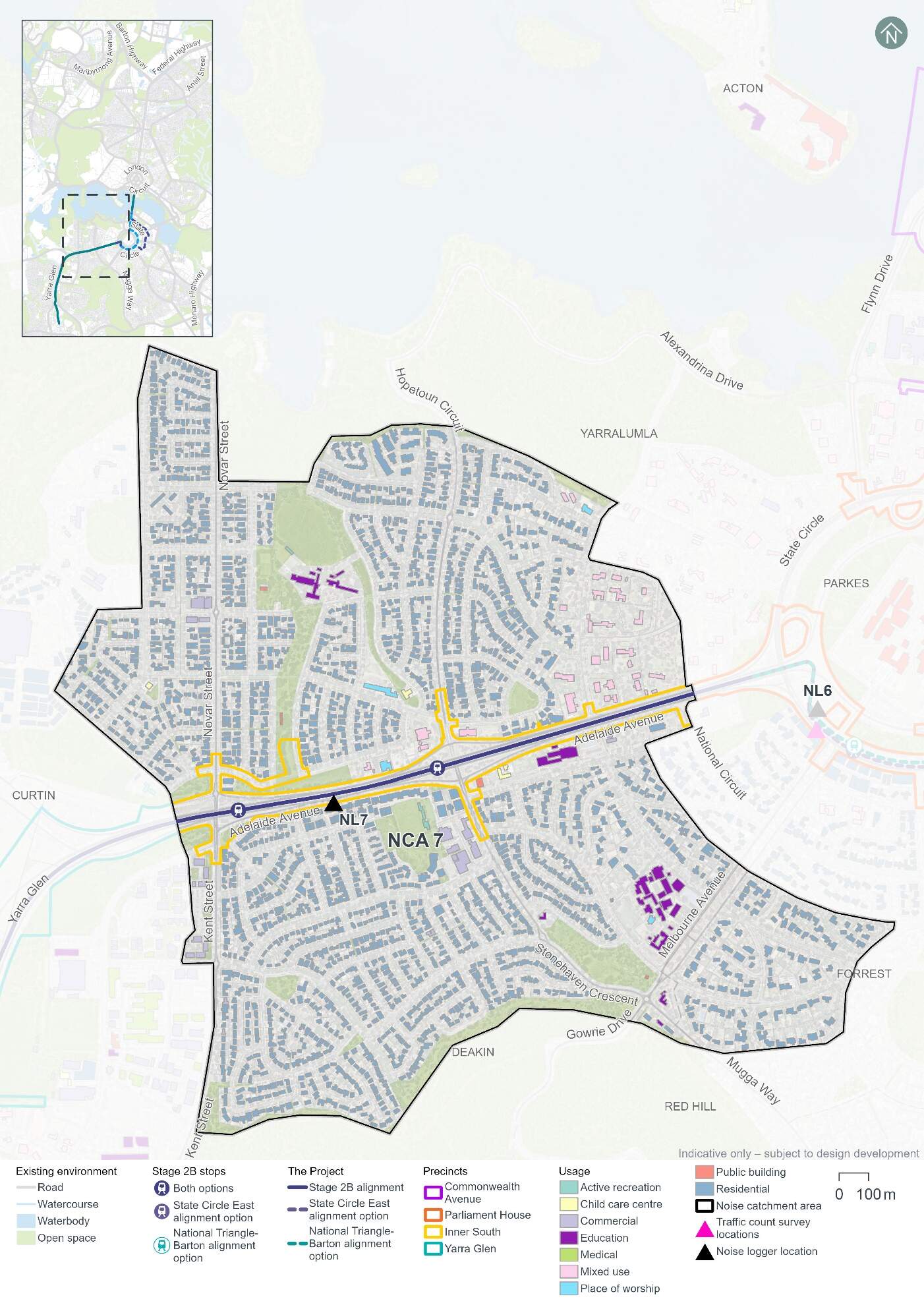
Noise Catchment Areas were determined based on the general ambient noise environment of the area, and the types of receivers and land uses potentially affected by the Project. Noise Catchment Area 7 was identified for the noise assessment of the Inner South precinct. Noise Catchment Area 7 and associated sensitive receivers are shown in Figure 16-8.
The majority of the land uses within Noise Catchment Area 7 are suburban residential developments to the north and south of Adelaide Avenue. Other land uses include commercial, public buildings, childcare centres, and educational land uses. There are also several mixed-use land uses (international embassies) to the east of the catchment area.
The Lodge (listed on the Commonwealth Heritage List) is also located within the Noise Catchment Area at its eastern extent, near its boundary with the Parliament House precinct. Further detail on heritage places in this precinct is included in Section 16.5.
Existing noise levels
Unattended noise monitoring was carried out at one location in the Inner South precinct (at noise logger 7 (NL7)) between 2 and 15 May 2024, to provide a representation of existing background noise levels. The background noise levels at this location are primarily driven by proximity to the Adelaide Avenue road corridor. The results of this monitoring are summarised in Table 16-13.
The LA90 level is the noise level exceeded for 90% of the sample period, and the LAeq level is the energy averaged noise level over the 15-minute period.
| Location ID | Noise logger address | Rating background level (LA90), dB(A)1 | Ambient noise level (LAeq), dB(A)1 | ||
|---|---|---|---|---|---|
|
Day2 |
Night2 |
Day2 |
Night2 |
||
|
NL7 |
63 Newdegate Street, Deakin |
59 |
303 |
70 |
62 |
Notes:
- dB(A) represents A-weighted decibels, the relative frequency response used in sound measuring instruments.
- In accordance with the NSW Noise Policy for Industry (NSW Environment Protection Authority, 2017) time of day is defined as follows:
- Day - the period from 7 am to 6 pm Monday to Saturday or 8 am to 6 pm on Sundays and public holidays.
- Night - 10 pm to 7 am (Monday to Saturday); 10 pm to 8 am (Sundays and public holidays)
- Evening (not included in table) - the period from 6 pm to 10 pm.
Attended noise measurements were also carried out at each unattended monitoring location on 1 May 2024 during the daytime period. The results of this monitoring are summarised in Table 16-14.
| Location ID | LAeq dB(A) | LA90 dB(A) | Comments |
|---|---|---|---|
|
NL7 |
68 |
61 |
Noise recorded was primarily traffic noise from Adelaide Avenue. |
16.3.2 Potential impacts - construction
The following sections present construction noise and vibration assessment results without the application of mitigation measures (referred to as unmitigated). Measures in Chapter 21 (Environmental management and mitigation measures) and Appendix L (Environmental Management Plan outline) would be implemented to manage these potential impacts. With the application of these mitigation measures it is expected that the unmitigated impacts would be noticeably reduced or, in some cases, avoided altogether.
Construction noise
Approach
In accordance with Section 29 and Item 16 of Schedule 2 Table 2.3 of the ACT Environment Protection Regulation 2005, construction of light rail or major roads do not require noise to be assessed against specific numerical noise limits as they are not taken to cause environmental harm. Item 16 of Table 2.3 places no conditions on the “Noise emitted in the course of constructing or maintaining a major road, a dedicated bus way, a railway or light rail.” Section 9.11 of the Environment Protection (Noise) Environment Protection Policy 2010 provides the following reasoning for the exemption of roadworks, noting that “the construction and maintenance of roads is central to the economic and social well-being of the community.”
In the absence of Territory specific quantifiable criteria, the NSW Interim Construction Noise Guideline (NSW Department of Environment and Climate Change, 2009) has been used to guide this assessment, as the Project would be of a large scale and occur within a relatively close proximity to noise sensitive receivers.
While construction noise generated by the Project is not required to be assessed against specific numerical noise limits, the derived assessment levels used in this EIS provide an indication of potential noise impacts to assist in the identification of appropriate mitigation measures, and were based on the NSW Interim Construction Noise Guideline (NSW Department of Environment and Climate Change, 2009).
The construction noise assessment presents a worst-case assessment which adopts conservative assumptions. For example, the noise model has used the shortest separation distance between worksites and each sensitive receiver, and has assumed the noisiest equipment would be in use. Actual construction noise levels experienced by receivers would generally be lower than the construction noise predictions. Modelling assumptions are discussed further in Technical Report 9 - Noise and vibration.
Scenarios
The noise assessment considers noise impacts from concurrent construction work across multiple precincts, but the results are reported at a precinct level.
The following construction scenarios have been modelled as a part of the noise and vibration impact assessment for the Inner South precinct:
- Mobilisation and establishment of construction compound sites
- Protection, relocation, treatment and/or decommissioning of utilities
- Earthworks, road works and construction of light rail infrastructure
- Construction of stops
- Construction of bridges on land.
Finishing works, including rectification of any defects, would be carried out progressively during construction and have been considered in the assessment of each scenario described above. Testing and commissioning works are not expected to entail any additional noise and vibration impact beyond the standard operation of the Project; therefore a quantitative assessment has not been undertaken.
Construction activities for the Project would be undertaken between the hours of 7am and 6pm Monday to Saturday (standard construction hours), as far as practicable. As outlined in Section 6.5 of Chapter 6 (Construction), some work would likely be required outside of standard construction hours to minimise disruptions to traffic, minimise disturbance to surrounding landowners and businesses, and/or maintain safe and efficient operation of key roads and public transport facilities. Work proposed outside of standard construction hours would require assessment and approval on a case-by-case basis, as outlined in mitigation measure NV3 in Chapter 21 (Environmental management and mitigation measures).All construction scenarios have been assessed based on work occurring during standard construction hours and during out of standard hours periods, with the exception of mobilisation and establishment of construction compound sites, which was only assessed as occurring during standard construction hours.
Construction noise scenarios have been categorised into 'peak and 'typical' works to represent the likely range of potential noise impacts. 'Peak' works represent the noisiest works which require the use of noise intensive equipment such as concrete saws and rock breakers, while 'typical' works represent typical noise emissions from a construction scenario when noise intensive equipment is not in use. Consequently, the 'typical' scenarios would result in a reduced number of noise affected receivers compared to 'peak' scenarios. Where possible, peak works and other high noise generating works would be carried out during standard construction hours. Should high noise impact activities be required to be undertaken outside of standard construction hours, they would be subject to specific controls identified in mitigation measures NV3 and NV4 (refer to Chapter 21 (Environmental management and mitigation measures)).
Assessment results
The number of residential buildings where receivers are predicted to be moderately or highly noise affected is shown in Table 16-15, which assumes no mitigation measures are in place. The number of buildings where noise levels are predicted to result in moderately affected receivers are separated into day and night-time periods, as appropriate.
The number of non-residential buildings predicted to be moderately noise affected is shown in Table 16-16.
Construction noise modelling has been completed assuming the noisiest equipment would be in use on the boundary of the Project area footprint, allowing for a worst-case scenario to be assessed. Section 3.2 of Technical Paper 9 - Noise and vibration provides further detail on the assessment approach.
Construction noise modelling indicates that there would be no difference in noise impacts in this precinct based on the alignment option selected.
| Construction scenario | Construction work category | Predicted noise affected residential buildings1 (unmitigated) | ||
|---|---|---|---|---|
| Standard construction hours - moderately noise affected | Outside of standard construction hours (night-time) - moderately noise affected | Highly noise affected2 | ||
| Noise Catchment Area 7 | ||||
|
Mobilisation and establishment of construction compound sites |
Peak |
- |
N/A |
- |
|
Typical |
- |
N/A |
- |
|
|
Protection, relocation, treatment and/or decommissioning of utilities |
Peak |
49 |
903 |
196 |
|
Typical |
4 |
287 |
72 |
|
|
Earthworks, road works, and construction of light rail infrastructure |
Peak |
44 |
792 |
196 |
|
Typical |
20 |
477 |
118 |
|
|
Construction of stops |
Typical/peak |
- |
31 |
- |
|
Construction of bridges on land |
Peak |
5 |
843 |
88 |
|
Typical |
- |
213 |
21 |
|
Notes:
- The noise levels in this assessment represent predicted noise levels at each building façade. Individual buildings have each been assessed as a single receiver, including where they are located at the same address or are part of the same facility. At multistorey buildings, the construction noise assessment documents noise levels for the most affected floor.
- Moderately noise affected receivers have been determined with consideration of the measured existing ambient noise levels, while the highly noise affected noise criteria do not consider existing ambient noise levels. Therefore, a receiver can be counted as both moderately noise affected and highly noise affected.
| Construction scenario1 | Building/area usage | Number of non-residential noise sensitive buildings assessed to be moderately noise affected2,3 (unmitigated) |
|---|---|---|
|
Noise Catchment Area 7 |
||
|
Protection, relocation, treatment and/or decommissioning of utilities - peak |
Child care centre |
3 |
|
Education |
2 |
|
|
Place of worship |
1 |
|
|
Public buildings |
2 |
|
|
Protection, relocation, treatment and/or decommissioning of utilities - typical |
Child care centre |
2 |
|
Education |
2 |
|
|
Place of worship |
1 |
|
|
Public buildings |
1 |
|
|
Earthworks, road works, and construction of light rail infrastructure - peak |
Child care centre |
2 |
|
Education |
2 |
|
|
Place of worship |
1 |
|
|
Public buildings |
2 |
|
|
Earthworks, road works, and construction of light rail infrastructure - typical |
Child care centre |
2 |
|
Education |
2 |
|
|
Place of worship |
1 |
|
|
Public buildings |
2 |
|
|
Construction of bridges on land - peak |
Child care centre |
2 |
|
Education |
1 |
|
|
Place of worship |
1 |
|
|
Public buildings |
1 |
|
|
Construction of bridges on land - typical |
Child care centre |
2 |
Notes:
- Where a construction scenario did not result in any non-residential building being moderately noise affected, it has not been included in this table
- Buildings have been assessed when in use, which is assumed to be the daytime period for most buildings, except hotels which have been assessed for day and night-time periods.
- The noise levels in this assessment represent predicted noise levels at each building façade. Individual buildings have each been assessed as a single receiver, including where they are located at the same address or are part of the same facility. At multistorey buildings, the construction noise assessment documents noise levels for the most affected floor.
The findings of the unmitigated peak and typical construction noise impact assessments for the Inner South precinct during the daytime indicate:
- The 'peak' protection, relocation, treatment and/or decommissioning of utilities is predicted to result in 49 residential buildings being moderately noise affected
- The 'peak' protection, relocation, treatment and/or decommissioning of utilities scenario is predicted to result in eight non-residential receiver buildings being moderately noise affected, including two buildings within Canberra Girls Grammar Junior School, two buildings within Canberra Girls Grammar School Early Learning Centre, Papilio Early Learning Yarralumla, the Margaret Dimoff Art Gallery, the Yarralumla Guide Hall, and Canberra House of Prayer. It is understood that Canberra House of Prayer offers temporary residential accommodation. To be conservative the building has been assessed as a place of worship as this attracts a more stringent noise criteria compared to a hotel or commercial development.
The findings of the unmitigated peak and typical construction noise impact assessments for the Inner South precinct during the night-time period indicate:
- During out of hours, 'peak' protection, relocation, treatment and/or decommissioning of utilities is predicted to result in 903 residential buildings being moderately noise affected, and a total of 196 receivers are expected to be highly noise affected at times
- During out of hours, 'typical' earthworks, road works and construction of light rail infrastructure is predicted to result 477 residential receiver buildings being moderately noise affected, and a total of 118 receivers are expected to be highly noise affected
- There are two hotel (commercial) receiver buildings - Gates Cottage Bed & Breakfast and Practically Lakeside B&B - within the noise catchment area. They are not predicted to be moderately noise affected.
Sleep awakening assessment
A sleep awakening assessment has been carried out using the 'typical works' case for each scenario, except for the mobilisation and establishment of construction compound sites (which has been assessed for standard construction hours only, and therefore not included in the assessment). The 'typical' works case has been used as it is assumed that noise intensive equipment (for example concrete saws and rock breakers) used for peak works would not be used during the night. The assessment approach is described further in Section 3.2 of Technical Report 9 - Noise and vibration.
Table 16-17 summarises the number of residential buildings where noise levels are predicted to exceed the awakening reaction criteria for Noise Catchment Area 7, in the absence of mitigation measures.
Work would be carried out during standard construction hours where possible, and work proposed outside of standard construction hours would require assessment and approval on a case-by-case basis, as outlined in mitigation measure NV3 (refer to Chapter 21 (Environmental management and mitigation measures)). It is unlikely that night works would involve several large-scale construction activities occurring concurrently, and works such as road works or track installation would generally move progressively along the Project area. Therefore, not all receivers would be affected at any one time, or for the whole duration of the works. As a result, the assessment of sleep awakening impacts is considered to be conservative. Proposed construction work hours are described further in Section 6.5 of Chapter 6 (Construction).
| Construction scenario (typical works) | Number of residential buildings where unmitigated noise levels may exceed the sleep awakening reaction level |
|---|---|
|
Protection, relocation, treatment and/or decommissioning of utilities |
400 |
|
Earthworks, road works, and construction of light rail infrastructure |
703 |
|
Construction of stops |
50 |
|
Construction of bridges on land |
412 |
Noting the awakening reaction level is exceeded by a number of residential buildings with noise relating to the following construction scenarios:
- Protection, relocation, treatment and/or decommissioning of utilities
- Earthworks, road works and construction of light rail infrastructure
- Construction of stops
- Construction of bridges on land.
The assessment and approval process for any out of hours works that cannot otherwise be avoided (as noted above, in accordance with mitigation measure NV3) would involve confirming mitigation measures to be applied and consultation with potentially affected receivers. Should extended periods of night work be required, respite periods would be scheduled.
Construction vibration
Vibration intensive work has the potential to cause human discomfort or cosmetic damage to buildings and structures, if not appropriately managed. Key potential sources of vibration from the proposed construction activities would include vibratory rollers, vibratory piling rigs, and excavators with hydraulic hammer attachments. Table 4-3 of Technical Report 9 - Noise and vibration presents the minimum working distances to be maintained between vibration intensive work to avoid cosmetic damage or human discomfort. Appendix E of Technical Report 9 - Noise and vibration provides mapping of the minimum working distances for a large hydraulic hammer (which has been selected to represent one of the most vibration intensive pieces of equipment proposed to be used) for human response and cosmetic damage.
Human comfort
Potential exceedances of human comfort vibration criteria have been assessed for residential buildings. A number of residential buildings are located within the human response minimum working distance for a large hydraulic hammer (73 m from the Project area boundary). There is potential for exceedances of the human comfort criteria to occur depending on the duration, nature and location of the construction activity within the construction footprint. Any exceedances would be expected to be relatively short in duration due to the intermittent nature of vibration emissions.
Cosmetic damage
A number of light-framed structures are located within the minimum working distance for a large hydraulic hammer (22 m for light-framed structures). One heritage-listed structure, The Lodge (listed on the Commonwealth Heritage List), is located 32 metres from the Project area, within the minimum working distance (60 m for heritage and other sensitive structures).
The Lodge is located near the boundary of the Parliament House and Inner South precincts, and has the potential to be affected by works from both precincts. Potential noise and vibration impacts from works in the Parliament House precinct on The Lodge are assessed in Section 13.3.2.
Where the use of vibration intensive equipment within the relevant minimum working distances cannot be avoided, detailed inspection, vibration monitoring and consultation with the sensitive receivers would be undertaken. Further information on mitigation measures is provided in Chapter 21 (Environmental management and mitigation measures).
Construction road traffic noise
Construction traffic associated with construction compounds would be distributed across the road network. Section 6.7.1 of Chapter 6 (Construction) describes proposed heavy vehicle haulage routes. Heavy vehicle movements, which are likely to have the largest noise and vibration impact, would generally be for deliveries of construction plant, supplies and infrastructure, and to transport soil and waste materials.
A summary of the forecast 2031 traffic volumes without the Project, the additional traffic contributed by construction of the Project, and the resultant relative change in noise levels during the daytime (AM peak period, 8am to 9am) and night-time (10pm to 7am) are presented in Table 16-18. The year 2031 was selected as representative of the peak year of construction.
No increases in road traffic noise greater than 2 dB(A) have been identified along the proposed haulage routes within the Inner South precinct during either the daytime or night-time periods. Changes in noise levels of up to 2 dB(A) are not considered to be perceptible by the average listener.
| Route | Direction | Existing traffic (average hourly) | Additional construction traffic (peak hourly) | Relative increase, dB(A) | ||||
|---|---|---|---|---|---|---|---|---|
| Light | Heavy | Light1 | Heavy1 | |||||
|
Daytime assessment |
||||||||
|
Adelaide Avenue between Hopetoun Circuit and Kent Street |
Westbound |
1,520 |
114 |
1 |
5 |
0.1 |
||
|
Eastbound |
2,302 |
173 |
1 |
5 |
0.0 |
|||
|
Night-time assessment |
||||||||
|
Adelaide Avenue between Hopetoun Circuit and Kent Street |
Westbound |
215 |
16 |
19 |
2 |
0.5 |
||
|
Eastbound |
119 |
9 |
19 |
2 |
0.8 |
|||
Notes:
- Peak hourly volumes for additional construction light vehicles have been determined by first combining estimated volumes for construction activities and workforce and then halving for each direction. Peak hourly volumes for additional construction heavy vehicles have also been halved for each direction.
16.3.3 Potential impacts - operation
Operational rail noise and vibration
The following sections provide a summary of potential operational rail noise and vibration impacts in the Inner South precinct. The potential impacts are common to both alignment options, given the consistent Project design in this precinct.
Airborne rail noise assessment
Operational rail noise levels were predicted at each of the receivers within 300 m of the alignment. This included a total of 1,254 receivers in the Inner South precinct, including residential receivers, mixed use receivers, education and childcare centres, places of worship, medical receivers, public buildings and active recreation receivers, assuming no mitigation measures are in place. Operational rail noise was modelled based on indicative LRV design speeds identified along the alignment during the design development process.
The results of the operational rail noise assessment identified six exceedances of the airborne noise trigger levels, across four different receivers that would be in close proximity to the alignment. The noise sensitive receivers that would experience exceedances of the noise trigger level are presented in Table 16-19 and Table 16-20. At multistorey buildings, the airborne rail noise assessment documents noise levels for the most affected floor.
The majority of receivers assessed are not predicted to experience exceedances of the noise trigger levels. Predicted noise impacts are intermittent and last for a relatively short duration as the LRV passes the receiver and is not representative of a constant noise source.
| ID | Usage | Address | Predicted LAFmax noise level, dB(A) | LAFmax noise trigger level, dB(A) | Exceedance dB(A) |
|---|---|---|---|---|---|
|
2915 |
Residential |
41 Hampton Circuit, Yarralumla |
81 |
80 |
1 |
| ID | Usage | Address | Predicted daytime LAeq,1hr noise level, dB (A) | Daytime LAeq,1hr noise trigger level, dB(A)1 | Exceedance dB(A) |
|---|---|---|---|---|---|
|
2529 |
Education |
Canberra Girls Grammar School, 24 Grey Street Deakin |
59 |
53 |
6 |
|
2631 |
Education |
Canberra Girls Grammar School, 24 Grey Street Deakin |
56 |
53 |
3 |
|
3527 |
Childcare Centre |
Canberra Girls Grammar School Early Learning Centre, 20 Grey Street Deakin |
57 |
53 |
4 |
|
4035 |
Childcare Centre |
Canberra Girls Grammar School, 24 Grey Street Deakin |
57 |
53 |
4 |
|
4139 |
Place of Worship |
Canberra House of Prayer, 28 Guilfoyle Street Yarralumla |
58 |
53 |
5 |
Notes:
- Refer to Appendix F of Technical Report 9 - Noise and vibration for the location of identified receivers.
The predicted LAFmax noise levels are up to 1 dB(A) in excess of the trigger levels for residential receivers. Changes in noise level by up to 2 dB(A) are not considered to be perceptible by the average listener. Therefore, it is not considered reasonable to consider additional noise mitigation measures.
The predicted LAeq,1hr noise levels are up to 6 dB(A) in excess of the trigger levels for non-residential receivers, assuming no mitigation measures are in place.
Mitigation measures in Chapter 21 (Environmental management and mitigation measures) of the EIS would be implemented to manage potential operational noise impacts.
Ground-borne rail noise assessment
Ground-borne noise impacts for the Inner South precinct at the most affected (closest) receiver is presented in Table 16-21. Ground-borne noise levels at the most affected receiver (41 Hampton Circuit, Yarralumla) was predicted to exceed the ground-borne noise trigger levels.
| Address | Building use | Distance from track centreline, m | Speed of LRV, km/h | Ground-borne noise criteria (Night), dB(A) LASmax | Predicted ground-borne noise level, dB(A) LASmax |
|---|---|---|---|---|---|
|
41 Hampton Circuit, Yarralumla |
Residential |
30 |
70 |
35 |
37 |
Targeted mitigation is recommended when ground-borne noise levels are higher than the airborne noise levels. The airborne noise levels for internal spaces with windows open are predicted to be LAsmax 70 dB(A)for the most affected receiver during the night-time period. These airborne noise levels are higher than the ground-borne noise levels, and therefore no additional treatment is considered necessary for the alignment within the Inner South precinct to manage this impact.
Rail vibration assessment
The predicted vibration levels for the Inner South precinct at the most affected (closest) receiver is presented in Table 16-22. No sensitive receivers are expected to experience vibration dose value over the nominated human comfort criteria.
| Address and building usage | Distance from track centreline, m | Vibration Criteria (Daytime), m/s1.75 | Predicted equivalent vibration dose value (Daytime), m/s1.75 | Vibration Criteria (Night), m/s1.75 | Predicted equivalent vibration dose value (Night), m/s1.75 |
|---|---|---|---|---|---|
|
41 Hampton Circuit, Yarralumla Residential |
30 |
0.2 |
0.008 |
0.13 |
0.004 |
Road traffic noise assessment
The assessment of road traffic noise has been completed in accordance with the Roads ACT Noise Management Guideline (Transport Canberra and City Services, 2018). The road traffic noise criteria applicable to upgrading roads in existing areas is provided in Table 16-23.
| Existing traffic noise level at adjacent buildings, LAeq,15hr | Traffic noise level at adjacent buildings after road works completed |
|---|---|
|
> 60 dB(A) |
Equal to existing level (not greater than 65 dB(A)) |
|
55 - 60 dB(A) |
60 dB(A) |
|
< 55 dB(A) |
Not more than 5 dB(A) above existing level |
To assess the potential impact of the Project on noise sensitive buildings, relative increases in future road traffic noise levels have been predicted for the 'without Project' and 'with Project' scenarios for the year 2031 (selected to represent the year of opening) and 2041 (selected to represent 10 years after opening). The future traffic volumes take into account increased traffic growth and changes to the road network from the Project such as changes in traffic lane configuration, signals and redirected traffic (described further in Chapter 5 (Project description)).
For the Inner South precinct, existing road traffic noise levels on Adelaide Avenue are greater than 60 dBA. Future predicted road traffic noise levels would not noticeably increase, and are therefore considered acceptable.
The results of the road traffic noise assessment for each alignment option are presented in Table 16-24 to Table 16-27, for 2031 and 2041 scenarios respectively.
| Road assessed | Location | Direction | Traffic volumes without the Project (15hr) | Additional traffic with the Project (15hr) | Predicted relative increase noise level, dB(A) | Compliance | ||
|---|---|---|---|---|---|---|---|---|
| Light vehicle | Heavy vehicle | Light vehicle | Heavy vehicle | |||||
|
Adelaide Avenue |
71 Newdegate Street, Deakin |
Westbound |
30,682 |
2,668 |
-2,328 |
-202 |
0 |
Yes, no increase in traffic noise level |
|
Eastbound |
53,302 |
4,635 |
-2,730 |
-237 |
||||
| Road assessed | Location | Direction | Traffic volumes without the Project (15hr) | Additional traffic with the Project (15hr) | Predicted relative increase noise level, dB(A) | Compliance | ||
|---|---|---|---|---|---|---|---|---|
| Light vehicle | Heavy vehicle | Light vehicle | Heavy vehicle | |||||
|
Adelaide Avenue |
71 Newdegate Street, Deakin |
Westbound |
30,682 |
2,668 |
-1,375 |
-120 |
0 |
Yes, no increase in noise level |
|
Eastbound |
53,302 |
4,635 |
-6,115 |
-532 |
||||
| Road assessed | Location | Direction | Traffic volumes without the Project (15hr) | Additional traffic with the Project (15hr) | Predicted relative increase noise level, dB(A) | Compliance | ||
|---|---|---|---|---|---|---|---|---|
| Light vehicle | Heavy vehicle | Light vehicle | Heavy vehicle | |||||
|
Adelaide Avenue |
71 Newdegate Street, Deakin |
Westbound |
31,740 |
2,760 |
-2,857 |
-248 |
0 |
Yes, no increase in noise level |
|
Eastbound |
48,562 |
4,223 |
2,539 |
221 |
||||
| Road assessed | Location | Direction | Traffic volumes without the project (15hr) | Additional traffic with the Project (15hr) | Predicted relative increase noise level, dB(A) | Compliance | ||
|---|---|---|---|---|---|---|---|---|
| Light vehicle | Heavy vehicle | Light vehicle | Heavy vehicle | |||||
|
Adelaide Avenue |
71 Newdegate Street, Deakin |
Westbound |
31,740 |
2,760 |
-3,174 |
-276 |
0 |
Yes, no increase in noise level |
|
Eastbound |
48,562 |
4,223 |
-4,020 |
-350 |
||||
Fixed facilities noise assessment - Public Address systems
Public Address (PA) systems at light rail stops would present a fixed noise source during operations. Passenger announcements from PA systems at the various stops are likely to be infrequent and generally limited to emergency situations or where notable disruptions in service occur. The short-term nature of PA noise means that it is unlikely to dominate the LA10, 15min assessment noise level at any location. Within the Inner South precinct, stops are located at Hopetoun Circuit and Kent Street.
The Hopetoun Circuit Stop is located approximately 60 m from the nearest residential receivers.. Although noise from road traffic along Adelaide Avenue would dominate the noise environment, there is potential for annoyance if PA systems are audible at residences. The subjective impacts are however likely to be minimal given the relative infrequency of announcements, and existing background noise levels.
The Kent Street Stop is located approximately 60 m from the nearest residential receivers. Noise from Adelaide Avenue would dominate the noise environment. However, subjective impacts are likely to be minimal given the relative infrequency of announcements and the existing road embankments on the north and south sides of Adelaide Avenue that is likely to shield noise from the PA systems.
Fixed facilities noise assessment - Traction power substation noise
Within this precinct, TPS8 would be located off Guilfoyle Street. The predicted TPS noise levels at the nearest affected receiver are presented in Table 16-28. Based on the assessment, the TPS design is anticipated to meet applicable noise criteria.
| TPS location | Distance to nearest receiver, m | Predicted LA10 noise level, dB(A) | Night-time noise zone standard, LA10,15min, dB(A)1 | Compliance |
|---|---|---|---|---|
|
TPS8 - Yarralumla |
30 |
31 |
35 |
Yes |
Notes:
- Determined based on the Environmental Protection Regulation 2005
16.3.4 Precinct specific management and mitigation measures
Environmental management for this Project is detailed in Chapter 21 (Environmental management and mitigation measures). This includes construction and operational mitigation measures to manage noise and vibration impacts, that are applicable to the Project as a whole.
In addition to the Project-wide measures, mitigation measures to manage noise and vibration impacts that are specific to the Inner South precinct are shown in Table 16-29.
| ID | Objective | Management and mitigation measure | Timing |
|---|---|---|---|
|
NV14 |
Minimising operational noise and vibration through design - from traction power stations |
Traction power substations will be designed to:
|
Design and operation |
16.4 Biodiversity
This section describes the potential impacts of the Project on biodiversity and provides a summary of the biodiversity assessment for the Inner South precinct. Impacts to biodiversity for the Project as a whole are discussed in Section 11.2 of Chapter 11 (Project-wide issues). The methodology applied for the assessment is summarised in Chapter 10 (Assessment methodologies) and Section 3 of Technical Report 2 - Biodiversity.
16.4.1 Existing environment
This section provides an overview of the existing environment with respect to biodiversity within the Inner South precinct. Some biodiversity characteristics of the Project would extend across multiple precincts and are discussed in Section 11.2 including habitat connectivity, vegetation assessments, threatened fauna habitat, threatened flora, and pest plants.
Vegetation assessment
A total of 9.27 ha of vegetation is present in the Inner South precinct. Vegetation within the Inner South precinct is comprised of four vegetation communities. Table 16-30 and Figure 16-9 depict the extent and distribution of each vegetation community within the Inner South precinct.
| Vegetation community | Area (ha) |
|---|---|
|
ACT01.2 Tablelands Dry Tussock Grassland - (moderate diversity) |
0.01 |
|
Landscape plantings - Native |
3.33 |
|
Landscape plantings - Exotic |
1.62 |
|
Exotic grassland |
4.31 |
|
Total vegetation |
9.27 |
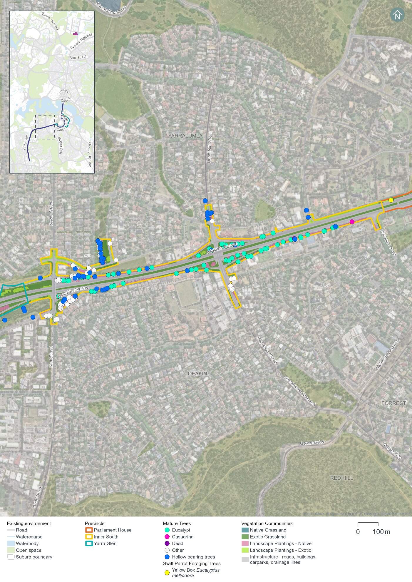
Hollow-bearing trees and mature trees
A total of 41 hollow-bearing trees and 95 mature trees have been recorded in the Inner South precinct. These trees provide suitable breeding and/or foraging habitat for woodland birds including those identified as having a moderate or high likelihood of occurrence.
The majority of the recorded hollow-bearing trees are species that are endemic to the ACT. A list of hollow-bearing and mature tree species across the Project area is provided in Section 11.2.1 of Chapter 11 (Project-wide issues). Table 16-31 summarises the number of hollow-bearing and mature trees within the Inner South precinct and is shown in Figure 16-9.
Field work carried out between 2022 and 2024 has identified evidence of some of the hollows being actively used with birds (including Gang-gang Cockatoos) entering and leaving the hollows and displaying breeding behaviours (i.e. chewing around the hollow entrance).
| Precinct | Number of hollow-bearing trees | Hollows1 | Number of mature trees | ||||
|---|---|---|---|---|---|---|---|
|
Extra-small |
Small |
Medium |
Large |
Extra-Large (>30 cm) |
|||
|
Inner South |
41 |
8 |
23 |
26 |
32 |
1 |
95 |
Notes:
- Some hollow-bearing trees have been recorded as containing more than one hollow.
Threatened fauna habitat assessment
The Golden Sun Moth is listed as vulnerable under both the EPBC Act and the NC Act. A total area of 0.98 ha of potential Golden Sun Moth habitat has been recorded within the Inner South precinct. This habitat has been identified as high quality (0.03 ha), low-quality (0.07 ha), low-density (0.27 ha), and high-density (0.61 ha) Chilean needlegrass habitat (refer to Figure 16-10).
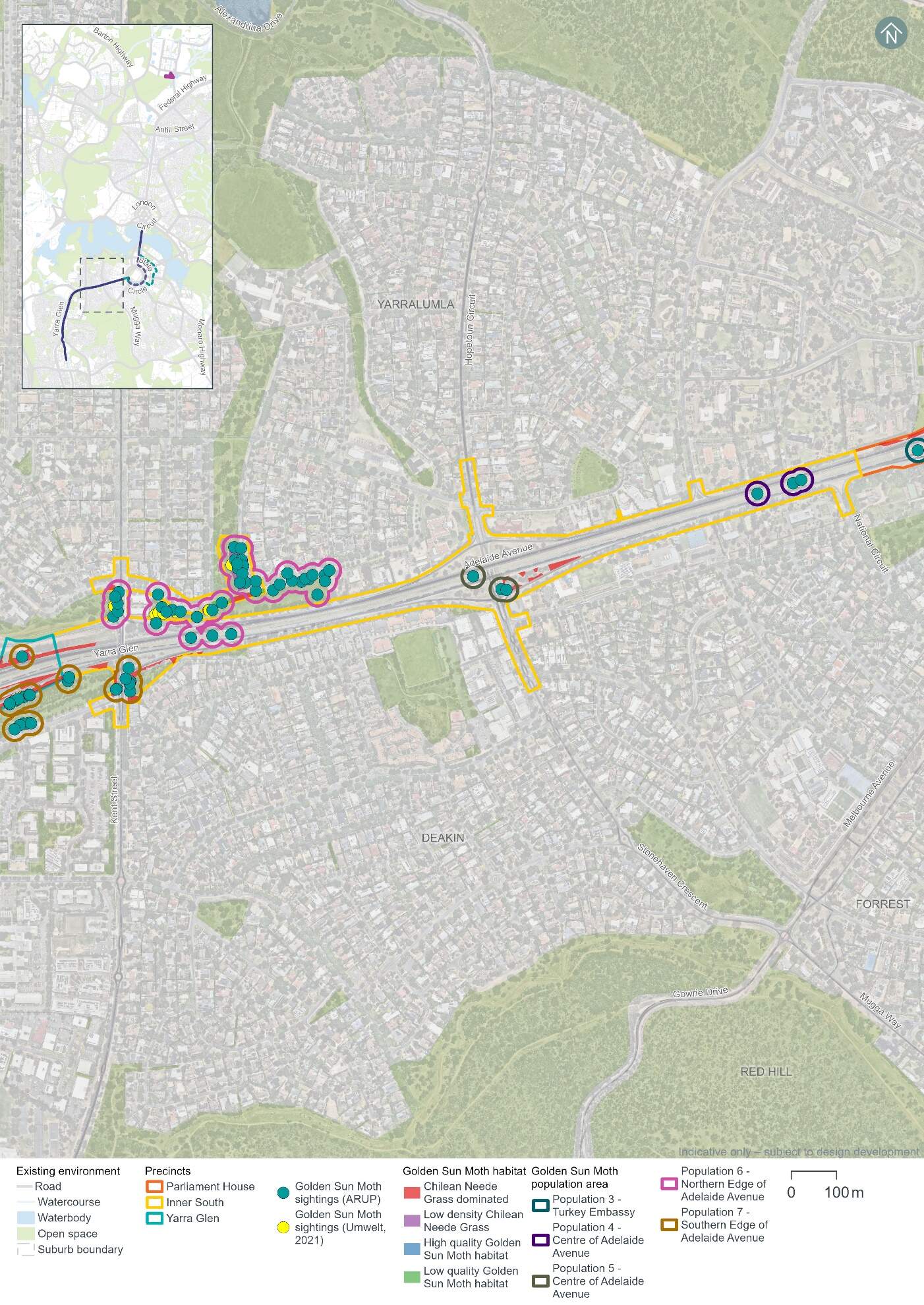
Five Golden Sun Moth populations has been identified in the Inner South precinct, through previous biodiversity assessments reviewed for this EIS (ARUP, 2021). The locations of the populations are shown in Figure 16-10 and include:
- Population 2 - around State Circle and Barton (Parliament House and Inner South precincts)
- Population 4 and 5 - in centre of Adelaide Avenue
- Population 6 - along the northern edge of Adelaide Avenue near the Cotter Road Junction
- Population 7 - along the southern edge of Adelaide Avenue near the Cotter Road Junction (Inner South and Yarra Glen precinct).
Other Golden Sun Moth populations and habitat across the Project area are identified in Section 11.2 in Chapter 11 (Project-wide issues).
Other potential threatened fauna habitat identified within the Inner South precinct includes:
- Gang-gang Cockatoo (listed as endangered under both the EPBC Act and the NC Act) - the Inner South precinct supports 3.33 ha of foraging habitat and 32 breeding trees (refer to Figure 16-11)
- Superb Parrot (listed as vulnerable under both the EPBC Act and the NC Act) - the Inner South precinct supports 3.33 ha of foraging habitat for this species (refer to Figure 16-11)
- Diamond Firetail (listed as vulnerable under both the EPBC Act and the NC Act.) - 3.33 ha of the Landscape Planting - Native community has been identified within the Inner South precinct and may provide suitable habitat for the Diamond Firetail as shown in Figure 16-11
- Perunga Grasshopper (Perunga ochracea) (listed as endangered un the NC Act) - the two small patches (0.01 ha) of moderate quality grassland (ACT01.2) community within the Inner South precinct may provide potential habitat for the Perunga Grasshopper
- Canberra Raspy Cricket (Cooraboorama canberrae) (recognised as rare but not listed under the EPBC Act or NC Act) - the two small patches (0.01 ha) of moderate quality grassland (ACT01.2) community within the Inner South precinct may provide suitable habitat for the Canberra Raspy Cricket
- Striped Legless Lizard (Delma impar) (listed as vulnerable under both the EPBC Act and NC Act.) - the two small patches (0.01 ha) of moderate quality grassland (ACT01.2) community within the Inner South precinct may provide suitable habitat for the Striped Legless Lizard. Although this patch of potential habitat is subject to routine mowing, due to the quality of the patch there is potential for it to support the species.
No habitat was identified in the Inner South precinct for the Swift Parrot (Lathamus discolor), or Key's Matchstick Grasshopper (Keyacris scurra).
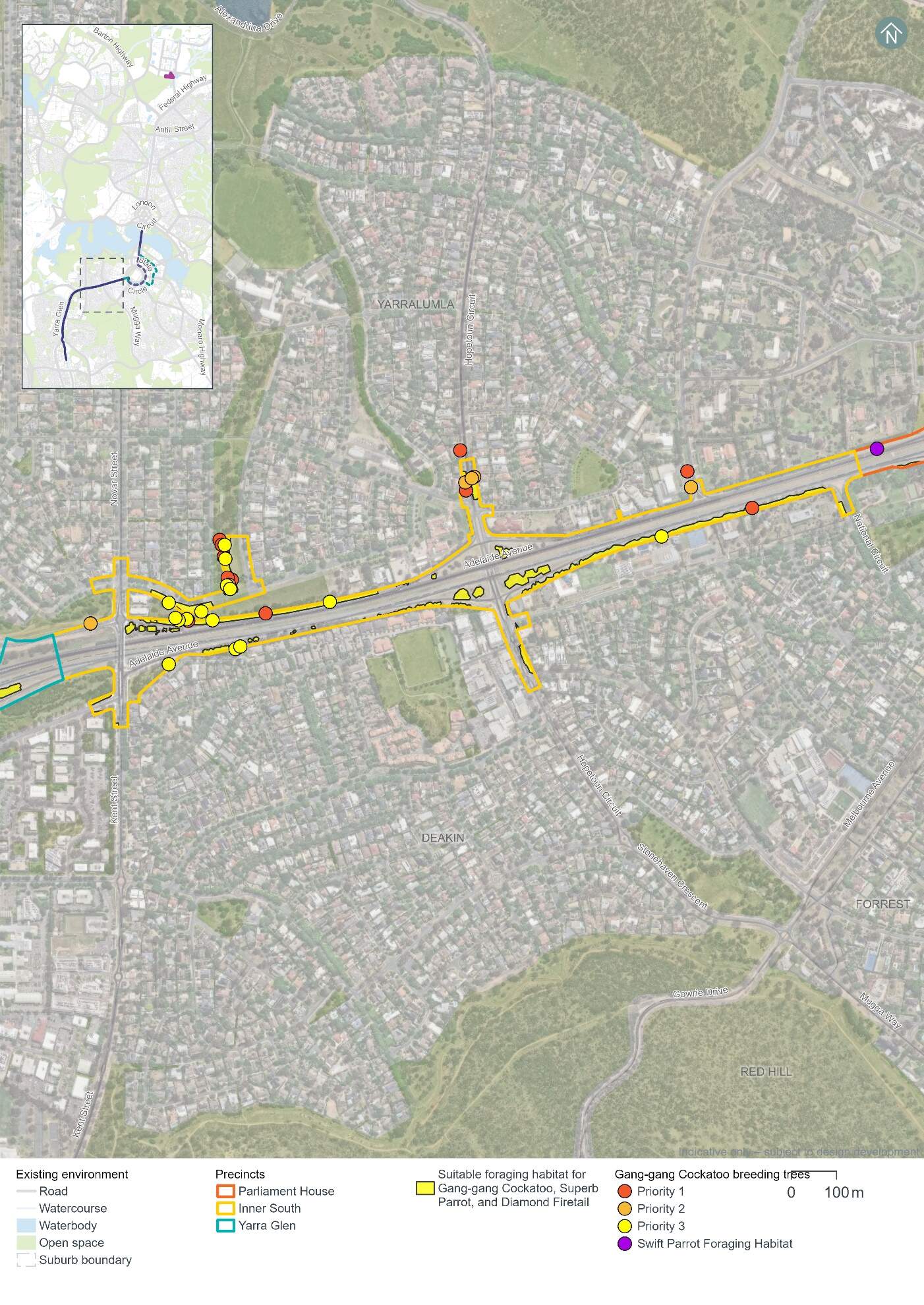
Threated flora and pest plants
No threatened or rare flora species have been recorded in the Inner South precinct. Impacts to threatened or rare flora species are therefore not anticipated.
Three pest plant species declared under the Pest Plants and Animals Act 2005 (PP&A Act) have been recorded in the Inner South precinct:
- Chilean needlegrass (Nassella neesiana) - a Weed of National Significance
- African lovegrass (Eragrostis curvula)
- Monterey pine (Pinus radiata).
16.4.2 Potential impacts - construction
The following section summarises the potential impacts of the Project on biodiversity as a result of construction in the Inner South precinct.
Vegetation assessment
The Project design has been developed with the aim of avoiding direct and indirect impacts to MNES and other biodiversity values in the landscape. Through this process, a clearance footprint has been defined, as shown in Figure 16-12. Vegetation clearing would not be permitted outside this clearance footprint.
Native and non-native vegetation within the clearance footprint is comprised of three communities as summarised in Table 16-32. Only 0.41 hectares of this vegetation is characterised as native, and all of it is landscape planting rather than remnant native vegetation.
| Vegetation community | Area (ha) |
|---|---|
|
Landscape plantings - Native |
0.41 |
|
Landscape plantings - Exotic |
0.17 |
|
Exotic grassland |
2.44 |
|
Total vegetation |
3.02 |
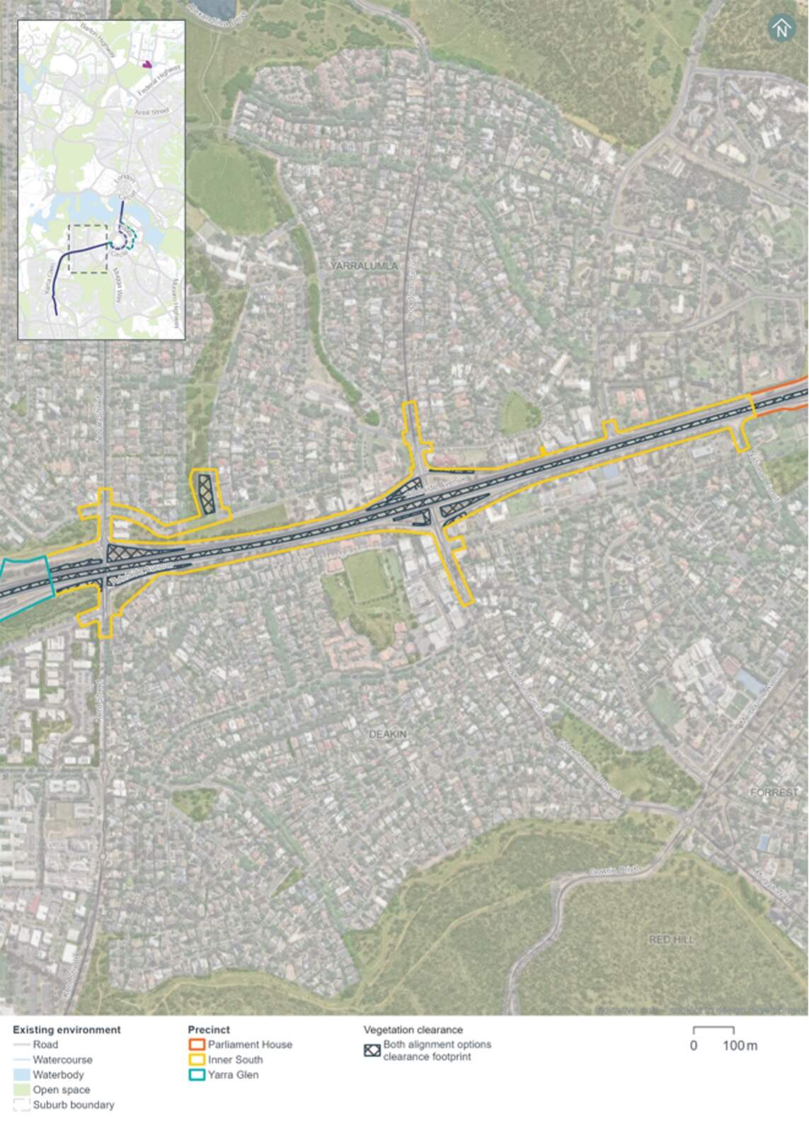
A total of 19 mature native trees have been recorded within the clearance footprint in the Inner South precinct. These trees provide suitable breeding and/or foraging habitat for woodland birds including those identified as having a moderate or high likelihood of occurrence. Table 16-31 summarises the number of hollow-bearing and mature native trees within the Inner South precinct and is shown in Figure 16-9.
Threatened fauna
Potential impacts on threatened fauna within the clearance footprint in the Inner South precinct would include impacts to the following through habitat removal:
- Golden Sun Moth - 0.43 ha of habitat, including habitat associated with Golden Sun Moth populations 2, 4, 5, 6, and 7
- Gang-gang Cockatoo - 0.41 ha of foraging habitat and one breeding tree, which when taken in total with all clearing required for the Project, has the potential to interfere with the recovery of the species
- Superb Parrot - 0.41 ha of foraging habitat for Superb Parrot, which when taken in total with all clearing required for the Project, has the potential to interfere with the recovery of the species
- Diamond Firetail - 0.41 ha of Landscape Planting - Native vegetation which may provide suitable habitat for the species.
Potential impacts on threatened fauna habitat across the clearance footprint is discussed further in Section 11.2.2 of Chapter 11 (Project-wide issues).
No habitat has been identified in the Inner South precinct clearance footprint for the Swift Parrot, Perunga Grasshopper, Canberra Raspy Cricket, Key's Matchstick Grasshopper, or Striped Legless Lizard.
Indirect impacts
Native vegetation and habitat adjacent to the clearance footprint, and species using air space above the clearance footprint may be indirectly impacted by the construction works if appropriate management and mitigation measures are not implemented. Management and mitigation measures for biodiversity are discussed further in Chapter 21 (Environmental management and mitigation measures). Potential indirect impacts of construction activities may include:
- Spread of invasive species in the clearance footprint from equipment and machinery
- Noise and vibration impacts on fauna within the vicinity of construction works
- Erosion, sedimentation, and dust impacts on biodiversity values during ground disturbing works
- Waste impacts associated with the storage of fuels and disposal of waste from new equipment and the removal of existing infrastructure
- Increased light pollution on sensitive habitats and species from increased light spill and lighting intensity during construction works
- Fauna strike by construction vehicles within and adjacent to existing roadways.
Further detail on these indirect impacts for construction activities is discussed in Chapter 11 (Project-wide issues).
16.4.3 Potential impacts - operation
Native vegetation and habitat adjacent to the clearance footprint, and species using air space above the Project have the potential to experience indirect impacts from the operation of the Project, for example:
- Noise and vibration impacts within the vicinity of the alignment, from light rail operations
- Increased light pollution on sensitive habitats and species, for example due to lighting around light rail stops
- The addition of light rail vehicles within an existing transport corridor increasing the risk of fauna strike
- Fauna strike with over-head wires and associated infrastructure (from Hopetoun Circuit Stop onwards heading south).
Further detail on these indirect impacts for operational activities is discussed in Chapter 11 (Project-wide issues).
16.4.4 Precinct specific management and mitigation measures
The Project has sought to avoid and minimise impacts to MNES and other biodiversity values in the landscape, through the development of a minimised clearance footprint within the Project area (refer to Figure 16-12).
Environmental management and mitigation measures are detailed in Chapter 21 (Environmental management and mitigation measures). This includes construction and operational mitigation measures to manage biodiversity impacts, that are applicable to the Project as a whole.
No precinct-specific measures have been identified for biodiversity impacts in the Inner South precinct.
16.5 Historic heritage
This section provides a summary assessment of the potential historic heritage impacts associated with the construction and operation phases of the Project within the Inner South precinct. Further detail on the heritage impact assessment is provided in Technical Report 3 - Heritage. The methodology applied for this assessment is summarised in Chapter 10 (Assessment methodologies) and discussed in detail in Section 2 of Technical Report 3 - Heritage.
Historic cultural landscapes, natural heritage, and heritage views and vistas have been assessed on a Project-wide basis as such features span across multiple precincts (refer to Section 11.3 of Chapter 11 (Project-wide issues)).
16.5.1 Existing environment
This section provides an overview of the existing historic heritage features within the Inner South precinct. It also considers the condition, integrity, and sensitivity to change of historic heritage features within the precinct.
Heritage character
The heritage significance of the Inner South precinct arises from its expression of National Capital Development Commission (NCDC) -era (1960 to 1980) development of Canberra and connection with the surrounding suburbs. Attributes include the wide boulevard of Adelaide Avenue, as one of the pieces of major infrastructure which helped complete Canberra, and the long views to distant mountains which give a strong backdrop to the NCDC-era suburbs (such as Deakin).
Additionally, the Inner South precinct provides features which create reminders the unique character of Canberra as the national capital. These include The Lodge, the visual and physical connection with Capital Hill, and views from Adelaide Avenue containing national institutions such as The Lodge and a variety of embassies.
The historic heritage assessment identified two heritage places (one listed and one unlisted) surrounding the Inner South precinct, as noted below in Table 16-33 and shown in Figure 16-13.
| Heritage places | Description |
|---|---|
|
Commonwealth Heritage List |
|
|
The Lodge (refer to Figure 16-14) |
|
|
Unlisted significant heritage places |
|
|
Canberra: the Planned National Capital |
Canberra's planned national landscape is a significant expression of the Griffin Plan that is highly valued by the Canberra and Australian communities. It is formed of public parklands, significant views along axes and across the Central National Area, tree-lined boulevards, a geometric layout, and Lake Burley Griffin. The landscape is nationally significant due to its:
Given this heritage place spans multiple precincts, it is assessed in Section 11.3 of Chapter 11 (Project-wide issues). It also applies to the landscape of Canberra as a whole and is therefore excluded from Figure 16-13 and is not considered further in this precinct assessment. |
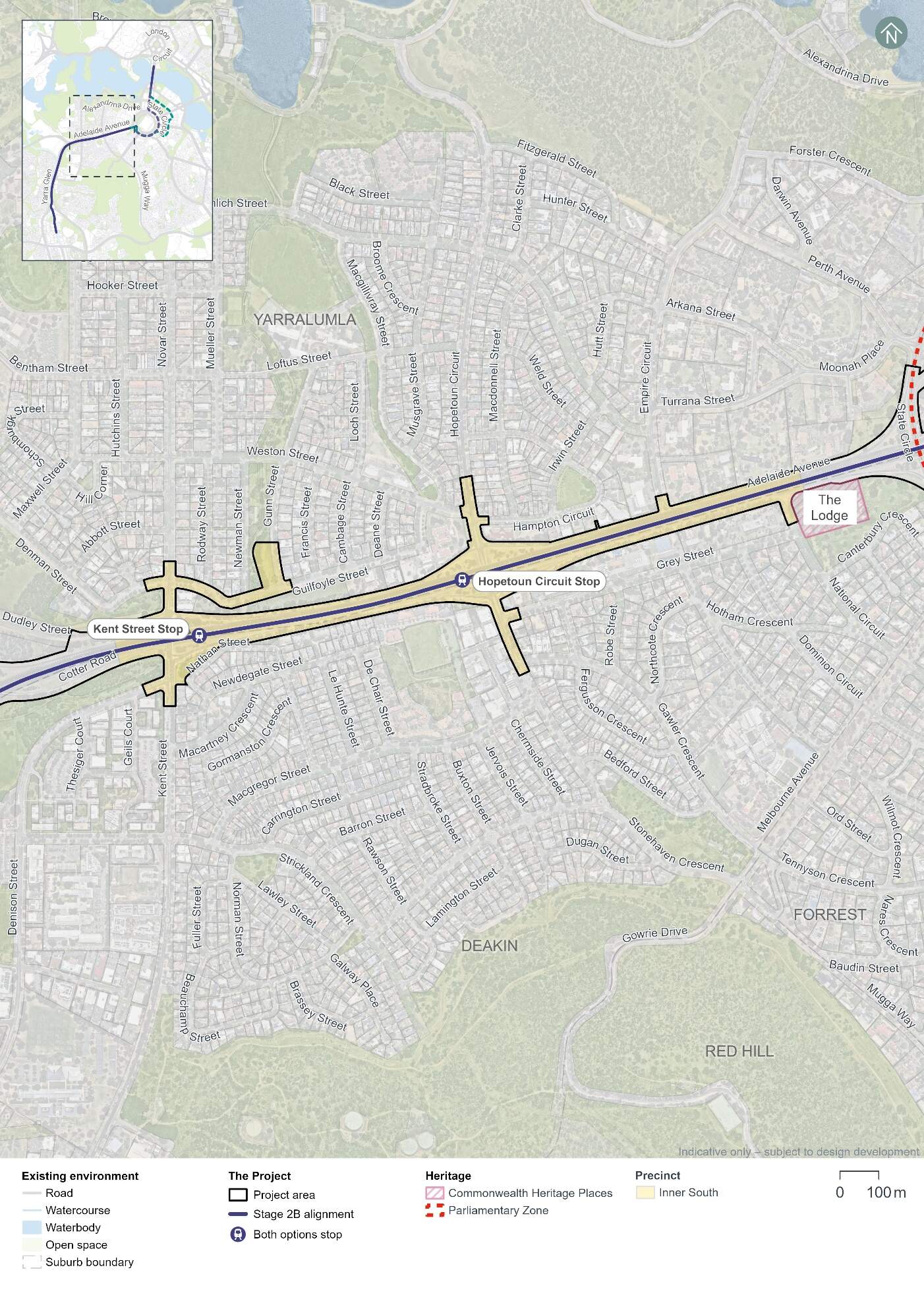
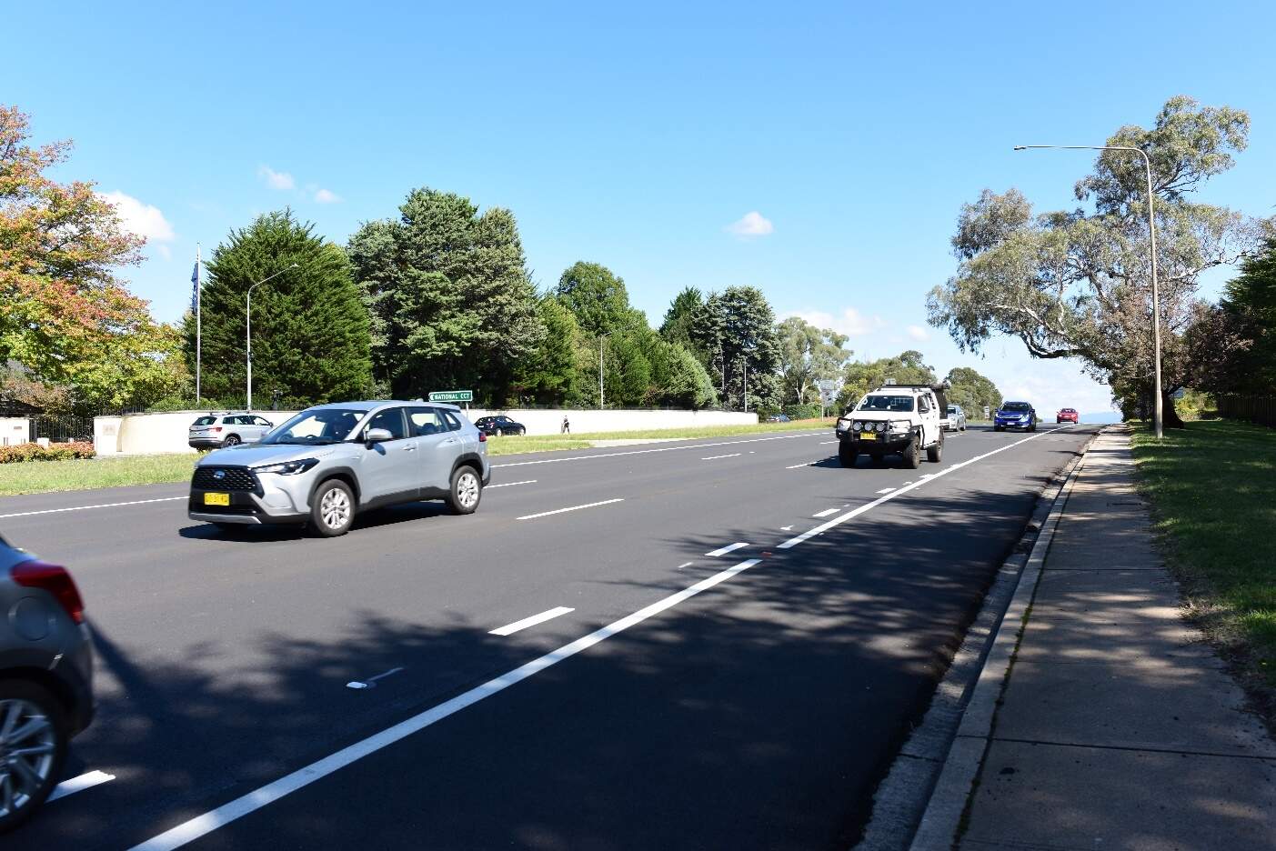
Condition, integrity, and sensitivity to change
The existing heritage within the Inner South precinct is generally in good condition. The roads and verges, landscape and planting, and significant heritage places are well maintained.
The integrity of the heritage values is good. The heritage features of the precinct are effective in expressing their character as part of the historic NCDC-era. Adelaide Avenue forms a significant piece of NCDC-era architecture passing through the suburbs of the Inner South which were constructed during the rapid population growth of the 1960s and 70s. The view to the mountains to the south-west is unimpeded.
The precinct has low to moderate sensitivity to change. The expression of the precinct's heritage character is via the location and form of Adelaide Avenue, its proximity to surrounding suburbs and relationship to inner and distant hills. These features can tolerate a reasonable amount of change. Views to the mountains south-west of the precinct along the corridor of Adelaide Avenue are more sensitive to change from development which would obscure these view lines.
16.5.2 Potential impacts - construction
Table 16-34 summarises the potential construction impacts of the Project on heritage places in the Inner South precinct.
| Heritage place | Construction impact |
|---|---|
|
Commonwealth Heritage List |
|
|
The Lodge |
Nil
|
Construction impacts on Canberra: the Planned National Capital have been assessed in Section 11.3 of Chapter 11 (Project-wide issues).
16.5.3 Potential impacts - operation
Table 16-35 summarises the potential operation impacts of the Project on heritage places in the Inner South precinct.
| Heritage place | Operation impact |
|---|---|
|
Commonwealth Heritage List |
|
|
The Lodge |
Minor to moderate
|
Operation impacts on Canberra: the Planned National Capital have been assessed in Section 11.3 of Chapter 11 (Project-wide issues).
16.5.4 Precinct specific management and mitigation measures
Environmental management for this Project is detailed in Chapter 21 (Environmental management and mitigation measures). This includes construction and operational mitigation measures to manage historic heritage impacts, that are applicable to the Project as a whole.
No further precinct-specific measures have been identified for historic heritage impacts at the Inner South precinct.
16.6 Landscape character and visual amenity
This section provides an assessment of the potential landscape character and visual amenity impacts associated with the construction and operation of the Project within the Inner South precinct. Further detail on the landscape character and visual amenity assessment is provided in Technical Report 10 - Landscape character and visual amenity. The methodology applied for the assessment is summarised in Chapter 10 (Assessment methodologies) and Section 2 of Technical Report 10 - Landscape character and visual amenity.
The landscape character assessment describes the physical, cultural and heritage attributes of the landscape, planning designations and desired character within each of the precincts. The assessment of visual impact has considered the impact of change on the views available to people and their visual amenity.
For the purposes of this assessment, the precinct boundaries have been expanded beyond the Project area, as shown in Figure 16-15.
16.6.1 Existing environment
The Inner South precinct follows Adelaide Avenue between the suburbs of Deakin and Yarralumla, from the National Capital Authority's (NCA) Diplomatic Precinct, including The Lodge and the employment area of west Deakin, to transition into Yarra Glen.
Adelaide Avenue is a dual carriageway with a wide turf median, and the view towards Parliament House is framed by mature native roadside vegetation that primarily screens adjacent built structures. Beyond this vegetated boundary are embassies, schools, religious institutions, and an art gallery, with the remaining land primarily consisting of residential development.
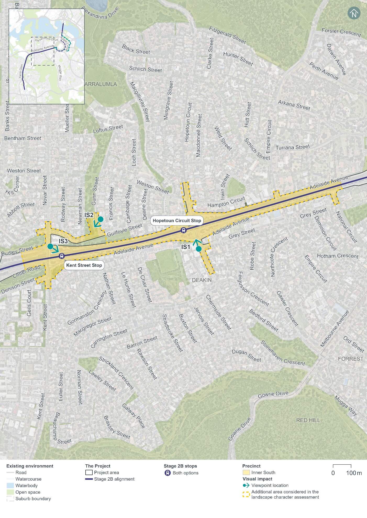
Landscape character
The key aspects of the landscape character in the Inner South precinct can be seen in Figure 16-16 to Figure 16-17. The Project would extend along Adelaide Avenue from National Circuit to slightly west of the Kent Street and the Novar Street Bridge. As a main avenue, Adelaide Avenue comprises part of the major design components of Canberra. The key focal points of Adelaide Avenue are Parliament House to the north-east (the corridor is one of the radiating avenues from State Circle, and the Brindabella Range to the south-west (refer to Figure 16-16). The focal points outside the precinct are accentuated with raised landform and include Capital Hill / Parliament House. Views along the main avenue are an integral design element, with dense buffer plantings on either side of the road corridor and minimal planting in the central median.
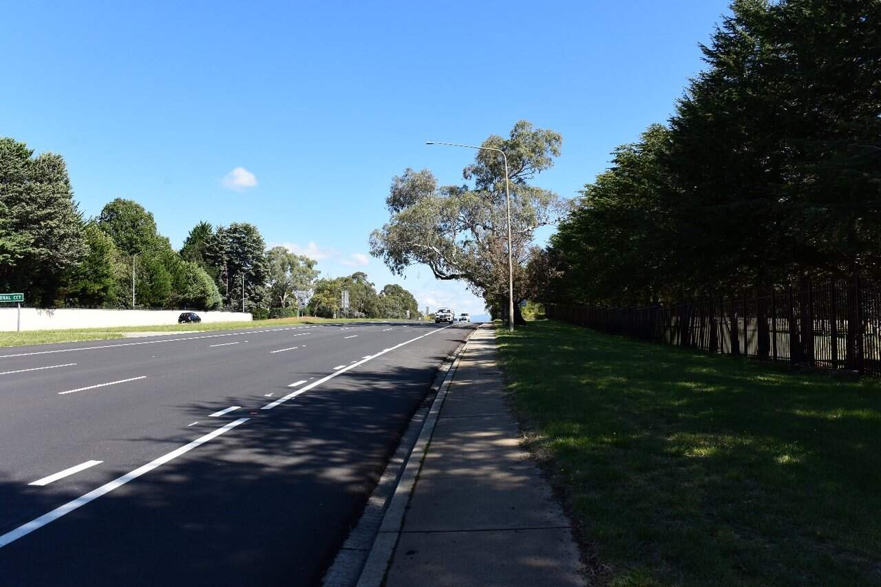
The north-eastern portion of the precinct interfaces with the Diplomatic Missions of Yarralumla, whereby the architecture of these buildings reflects their country's national architectural style, as shown in Figure 16-17. These buildings are situated on large blocks of land, often with large security infrastructure, in contrast to the residential areas. The Lodge, a Commonwealth Heritage listed property, lies adjacent to the route. Adelaide Avenue lies within NCA's 'Designated Land' as set out in the NCP, with a mix of land uses extending out beyond the corridor.
Fringing land uses adjacent to the precinct primarily include Suburban Residential, Community Facilities and Urban Open Spaces, typical of the low to medium density residential suburbs of Yarralumla and Deakin (refer to Figure 16-18).
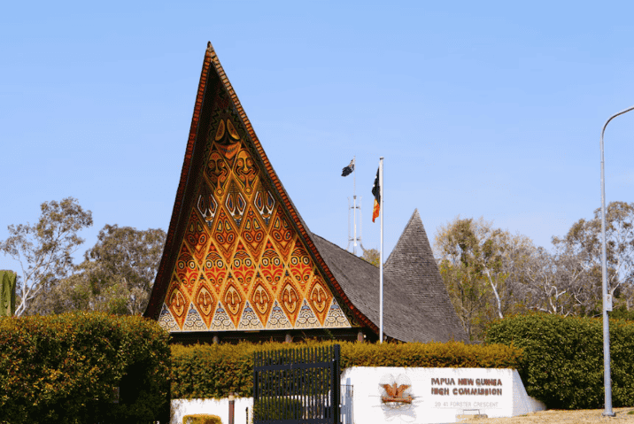
Viewpoints
Representative viewpoints that have been identified to assess changes to the Inner South precinct which are and shown in Figure 16-15 and described in Table 16-36. Images of all viewpoints can be found in Technical Report 10 - Landscape character and visual amenity.
| Viewpoint | Description | Sensitivity rating |
|---|---|---|
|
Viewpoint IS1: Hopetoun Circuit Covered Section |
This viewpoint is located on the western verge of Hopetoun Circuit looking north towards the northbound and southbound Adelaide Avenue carriageways (refer to Figure 16-20). The central view covers the road corridor of Hopetoun Circuit, extending from the foreground right of frame to the central background of the view. The connecting roads to Adelaide Avenue extend to the east and west in the foreground. Visual receptors seeing this view would primarily be pedestrians and motorists travelling along Hopetoun Circuit. Others would be residents seeing the view from their apartments. The viewpoint sensitivity is moderate. While residential receptors are a sensitive visual receptor group, the number of residents who would see this view is low, with a much higher number briefly passing this location in their cars or on foot. |
Moderate |
|
Viewpoint IS2: Traction Power Substation 8 |
This viewpoint looks towards a small park within a residential area, with the park flanked on two sides by residential streets (refer to Figure 16-22). The proposed Traction Power Substation (TPS) 8 would be located in the centre left of this viewpoint. Visual receptors seeing this view would primarily be residents of properties along the flanking streets, and pedestrians and motorists traveling past the park. The viewpoint sensitivity is high. The viewpoint is positioned within a residential street, where the sensitivity would relate to local residents who consider views from or near their properties important. The Project would be visible from within the street and potentially from within private properties. |
High |
|
Viewpoint IS3: Kent Street Overpass |
This viewpoint is located on the eastern pedestrian path at the northern end of the Kent Street and Novar Street Bridge overpass, looking east down onto Adelaide Avenue (refer to Figure 16-19). It includes a linear view along the road corridor, which is bounded by dense vegetation which screens views beyond the road. Visual receptors seeing this view would primarily be pedestrians crossing the bridge, looking over the path barricade to Adelaide Avenue below. The viewpoint sensitivity is low. Motorists are unlikely to be a sensitive visual receptor group as they would only see the view for short periods of time as they drove past the viewpoint, similarly, pedestrian receptors are likely to have a passing interest in the view. |
Low |
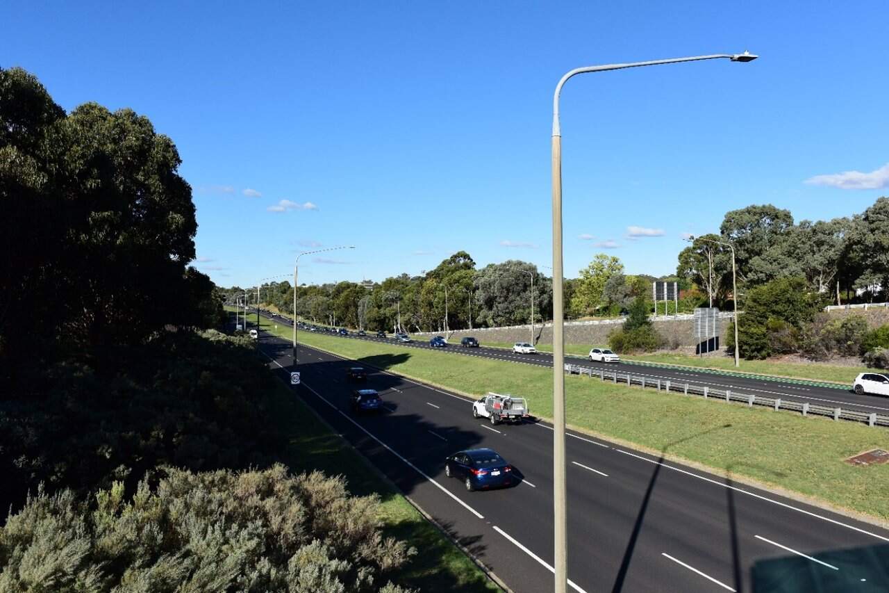
Night-time lighting
Both alignment options would sit within Adelaide Avenue road corridor and its surrounds. Due to its prominence within the structure of the Griffin Plan and its urban transport corridor character, Adelaide Avenue is an area of A4: High district brightness based on Australian Standard 4282:2023 (Standards Australia, 2023). Existing lighting within the precinct accentuates the Adelaide Avenue vista with surrounding roads sitting within the A3: Medium district brightness category.
The lighting following the proposed Project would contribute to the high quality landscape boulevards and direct views towards the feature lighting of Parliament House. Relevant design requirements of strategy 1a of the NCA's Outdoor Lighting Policy for the Inner South precinct include:
- Emphasise the three node points of the Griffins' National Triangle by creating and maintaining strong visual 'anchors' at Parliament House, City Hill and Russell
- Use full cut-off light fittings in all landscape areas, roads, paths and car parks within the Central National Area
- Use full cut-off street and pedestrian lighting on all main avenues that contributes to their development as high quality landscape boulevards
- Align lighting hardware to strengthen the framing of the National Triangle, main avenues and formally landscaped open spaces.
16.6.2 Potential impacts - construction
Landscape character impact assessment
The construction of the Project would result in both the addition (of construction activity and equipment) and loss of elements (most notably to trees) within the Inner South precinct, including:
- The addition of temporary fencing, hoarding, signage, and traffic safety equipment
- Removal of existing vegetation (most notably, trees), furniture, and signage, as needed
- Activities including earthworks, track construction, drainage adjustments, and road improvements
- Construction of structures, including light rail stops, retaining walls, bridges, and covered sections
- Installation of lighting, signage, and landscaping
- Temporary traffic changes.
These changes would alter many aesthetic aspects and key characteristics within the precinct.
Construction activities in any one location would be temporary and experienced over the short term (up to five years). As such, the magnitude of change during construction would be high within the Inner South precinct due to the visual clutter of construction and the removal of trees. This would result in a high to moderate adverse impact on landscape character during construction.
Visual impact assessment
The visual impact assessment considered the sensitivity of existing viewpoints to change and the magnitude (scale, character, and distance) of the change of view. During the construction phase within the Inner South precinct, in most cases the overall impact at each viewpoint has been assessed as being high to moderate due to the high magnitude of changes to each viewpoint.
A description of the anticipated change in view and associated potential impacts on the Project during construction is provided in Table 16-37.
| Viewpoint | Anticipated change in view | Impact rating |
|---|---|---|
|
Viewpoint IS1: Hopetoun Circuit Covered Section |
Construction would introduce temporary fencing, hoarding, signage, and traffic equipment, along with earthworks, drainage adjustments, and road improvements across both sides of the road. Construction of the light rail stop on Adelaide Avenue west of Hopetoun Circuit including access to the platform from Hopetoun Circuit and the light rail bridge structure over Hopetoun Circuit would also be introduced. The activity would be visually prominent in the fore, middle, and background, due to the scale and proximity of construction, contrasting with the established landscape, although no tree removal would occur. The moderate sensitivity of this view, proximity to residential properties, and the extensive visual changes -including height of construction along Adelaide Avenue above ground level-would result in a high to moderate adverse impact, as construction elements and visual clutter would dominate the view. |
Sensitivity: Moderate |
|
Magnitude: High |
||
|
Overall impact: High to moderate |
||
|
Qualitative rating: Adverse |
||
|
Viewpoint IS2: Traction Power Substation 8 |
Construction of the TPS would introduce earthworks, installation of substation structure and electrical equipment, and ground finishing. The activity would be visually prominent within a moderate portion of the view in the middle ground due to the scale and proximity of the equipment, contrasting with the established landscape, although no tree removal would occur. The high sensitivity of this view, and the substantial amount of change within the view, including large construction elements would result in a high adverse impact, as construction elements and visual clutter would dominate the view, rather than the parkland. |
Sensitivity: High |
|
Magnitude: High |
||
|
Overall impact: High |
||
|
Qualitative rating: Adverse |
||
|
Viewpoint IS3: Kent Street Overpass |
Construction would introduce temporary fencing, hoarding, signage, and traffic equipment, along with earthworks and construction of trackform, drainage adjustments, vegetation removal, and road improvements across both sides of the road. Construction of the light rail stop in the median of Adelaide Avenue east of the bridge, and the pedestrian and cyclist bridge structure over Adelaide Avenue would also be introduced. The activity would be visually prominentwithin the framed view along the road corridor, due to the scale and proximity of construction. The low sensitivity of this view and the proximity of construction activity within the road corridor, would result in a moderate adverse impact, as construction elements and visual clutter would dominate the view. |
Sensitivity: Low |
|
Magnitude: High |
||
|
Overall impact: Moderate |
||
|
Qualitative rating: Adverse |
Night-time visual impact assessment
Works within this precinct may need to be undertaken outside standard construction hours (Monday to Saturday, 7am to 6pm). Night works may also be required within the precinct with most of the night works occurring within and adjacent to the existing road corridor. No construction compounds would be located within the precinct.
The construction of Hopetoun Circuit carriageway under the northbound and southbound Adelaide Avenue carriageways would result in the most prominent lighting. These works would be more prominent in the landscape due to the road corridor sitting above the surrounding landscape and the large equipment required to construct these elements. This would be visible from key locations such as the Parliament House and the Telstra Tower on Black Mountain.
While night works would increase the existing light levels of this precinct, interventions such as planting, and use of topography would limit impact to surrounding properties. Residential properties most affected by the night works lighting would be those surrounding the Hopetoun Circuit Stop.
Lighting associated with night works may also draw attention away from the feature lighting of Parliament House, however mature tree planting would provide some visual buffering in sections of the precinct.
For these reasons, the visual impact during construction at night would be moderate adverse.
16.6.3 Potential impacts - operation
Landscape character impact assessment
The assessment of landscape effects considered the change due to the Project on the landscape as a resource in its own right. The assessment has been based on the sensitivity to change and the magnitude of the change that is likely to occur. A description of the anticipated change, and the associated potential impact is summarised in Table 16-38.
| Alignment option | Anticipated change | Impact rating |
|---|---|---|
|
Both alignment options |
The Project would introduce light rail infrastructure along Adelaide Avenue, including two stops, a light rail bridge between the existing Adelaide Avenue carriageways over Hopetoun Circuit, and the Hopetoun Circuit Stop Plaza. There would also be adjustments and the addition of trees to the Adelaide Avenue median. While the associated light rail infrastructure would be a new addition along Adelaide Avenue, it would retain the overall characteristic of the linear nature of the transport corridor framed by vegetative screening. Increased lighting and movement in response to the addition of the light rail stop in the median of Adelaide Avenue east of the bridge may impact adjacent residential properties, embassies, and art gallery. The addition of a substation within the residential suburb of Yarralumla would comprise a change to a very small portion of the precinct and would not alter any broader aspects of the precinct due to its small size and position within an existing reserve. While the Project would thoughtfully integrate with the existing infrastructure and preserve key spatial characteristics, it would result in an adverse change in the precinct's character due to the introduction of light rail infrastructure (including two stops and over-head wiring from Hopetoun Circuit westwards). |
Sensitivity: Moderate |
|
Magnitude: Moderate |
||
|
Overall impact: Moderate |
||
|
Qualitative rating: Adverse |
Visual impact assessment
The visual impact assessment considered the sensitivity of existing viewpoints to change and the magnitude (scale, character, and distance) of the change of view. During operation within the Inner South precinct, in most cases the overall impact at each viewpoint has been assessed as being high to moderate due to:
- A high to moderate magnitude of changes at each viewpoint
- The visual prominence of changes seen from each viewpoint.
A description of the anticipated change in view and associated potential impacts on the Project during operation is provided in Table 16-39.
| Viewpoint | Anticipated change in view | Impact rating |
|---|---|---|
|
Viewpoint IS1: Hopetoun Circuit Covered Section |
The Project would introduce light rail infrastructure, including a light rail stop, over-head wiring, and passing LRVs, juvenile trees along Hopetoun Circuit and Adelaide Avenue, and adjustments to footpaths. While there would be substantial changes within the view, these would be in keeping with the character of a transport corridor and would be visually softened by tree planting, resulting in a moderate overall impact. Trees planted would also, over time, screen the view to built elements within the plaza and at the stop. The overall impact would be neutral as there are positive (e.g. additional trees) and negative (e.g. light rail infrastructure) aspects of the Project when viewed from this location. An indicative visualisation of the Project, once operational, from Viewpoint IS1 is provided in Figure 16-21. |
Sensitivity: Moderate |
|
Magnitude: Moderate |
||
|
Overall impact: Moderate |
||
|
Qualitative rating: Neutral |
||
|
Viewpoint IS2: Traction Power Substation 8 |
The Project would introduce a piece of electrical infrastructure within the existing small residential park, resulting in a high to moderate overall impact. Although there would be an adverse effect on the view, the change would only affect a small to moderate proportion of the view and would become more visually recessive over time with the appropriate surrounding landscaping, including tree planting. An example of a TPS from LRS1 is provided in Figure 16-23. |
Sensitivity: High |
|
Magnitude: Moderate |
||
|
Overall impact: High to moderate |
||
|
Qualitative rating: Adverse |
||
|
Viewpoint IS3: Kent Street Overpass |
The Project would introduce a pedestrian and cyclist bridge with associated entry plaza, light rail stop below the eyeline of the view along Adelaide Avenue, light rail tracks within the median with occasional passing LRVs, as well as juvenile trees within the foreground of the view. The multiple changes would be seen from close proximity and in a high amount of detail, resulting in a moderate overall visual impact. Although the changes would be adverse, the most sensitive visual receptors (pedestrians) would not see the view at operation as they would be using the footbridge to cross Adelaide Avenue. Passing motorists are unlikely to see the change in as much detail. |
Sensitivity: Low |
|
Magnitude: High |
||
|
Overall impact: Moderate |
||
|
Qualitative rating: Adverse |
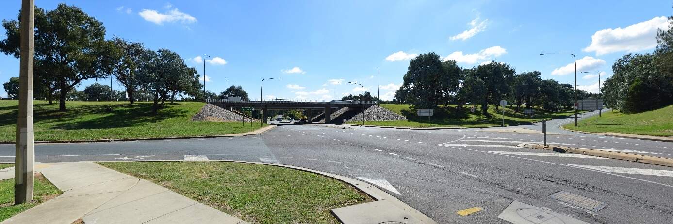
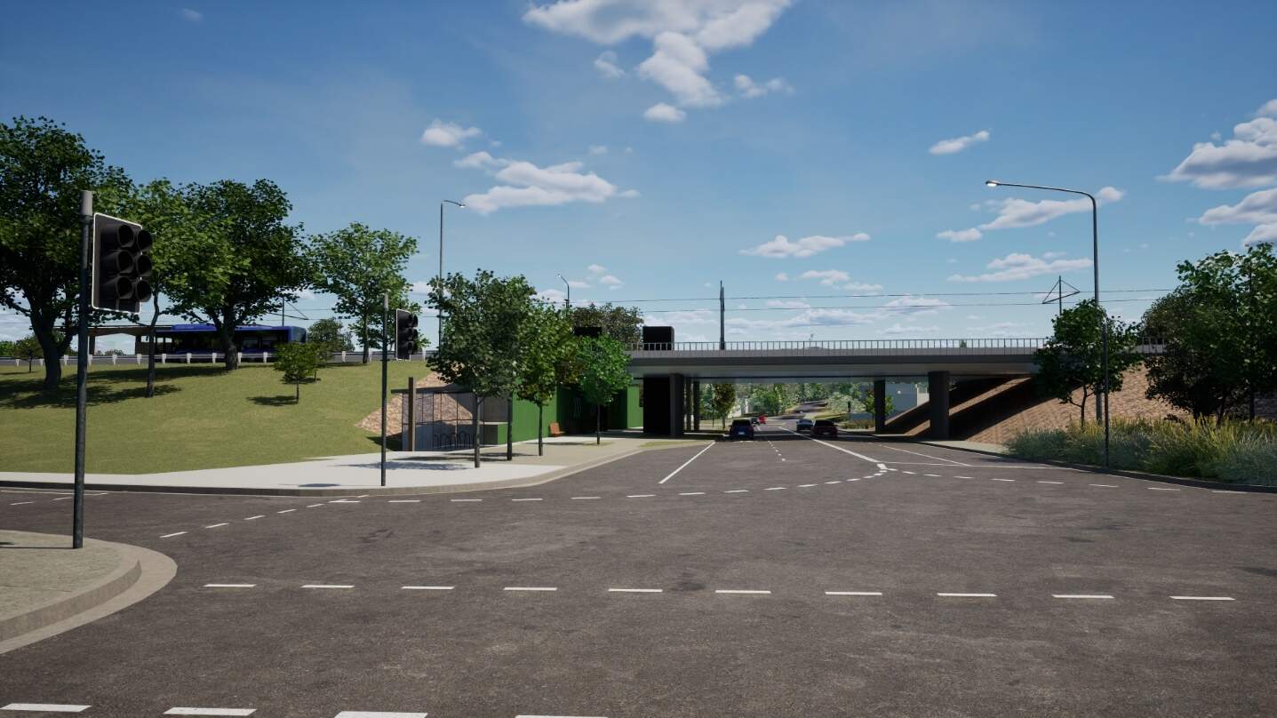
Night-time visual impact assessment
The Project would introduce additional lighting within the median, two light rail stops, and LRV headlights along the tracks. The proposed interventions would include the retention of existing street light poles along the road verge, and the installation of additional lighting to the light rail track. These lighting elements would be lower poles adjacent to the light rail track, aligned with the new trees. The proposed tree planting within the median would provide visual filtering of the lighting over time as the trees mature.
The most substantial change within the precinct due to the Project would be the lighting associated with the light rail bridge, stops, and Hopetoun Circuit under the northbound and southbound Adelaide Avenue carriageways. The light rail bridge would infill a previously open space between the carriageways, necessitating the need for additional lighting for Hopetoun Circuit during day and night. The development of the entry plaza to the proposed stop at Hopetoun Circuit would create opportunities for positive lighting outcomes, increasing safety for users and focus on gender sensitive urban design. The lighting associated with the Hopetoun Circuit Stop and covered section would create an increase in light spill for surrounding residences and diplomatic missions.
The light rail stop at Kent Street, would also introduce additional lighting within the precinct. However, retained dense vegetation would filter the impacts of light spill to surrounding residences.
Interventions such as planting, and use of topography along a majority of the alignment would limit the impact to surrounding properties. Properties most affected by the change would be those surrounding the Hopetoun Circuit Stop and properties facing the proposed TPS 8 structure. Low level strip lighting would be applied to the TPS 8 structure in line with the LRS1 and LRS2A designs. The lighting would sit within the TPS structure, behind the façade, however minor light spill would occur through the façade.
While the Project would introduce additional lighting elements within the precinct, the light rail corridor would align with the outcomes of the existing A4: High district brightness area within the context of a major transport corridor.
There would be a reduction in visual amenity at night due to the large extent of additional lighting, frequency of LRVs, and light spill surrounding local residences at the Hopetoun Circuit Stop. This is, however, a high district brightness environment, therefore the visual impact during operation would result in a moderate adverse impact at night.
16.6.4 Precinct specific management and mitigation measures
Environmental management for this Project is detailed in Chapter 21 (Environmental management and mitigation measures). This includes construction and operational mitigation measures to manage landscape character and visual amenity, that are applicable to the Project as a whole.
In addition to the Project-wide measures, mitigation measures to manage landscape character and visual amenity impacts that are specific to the Inner South precinct are shown in Table 16-40.
The Public Domain Master Plan (Appendix I) identifies design principles and guidance for the Project. These principles would be applied to the Project through ongoing design development and would contribute to management and mitigation of landscape and visual impacts of the Project during operation.
| ID | Objective | Management and mitigation measure | Timing |
|---|---|---|---|
|
LV10 |
Visual integration of traction power substations |
The scale and bulk of traction power substations will be refined to enable greater integration into the surrounding landscape. Material selection and finishes, lighting, landscaping and screen planting (including trees) will be used to minimise the visual presence of the substations. |
Design and operation |
16.7 Socioeconomic
This section describes the potential socioeconomic impacts of the Project within the Inner South precinct. Further detail on the socioeconomic assessment is provided in Technical Report 6 - Socioeconomic. The methodology applied for this assessment is summarised in Chapter 10 (Assessment methodologies) and discussed in detail in Section 4 of Technical Report 6 - Socioeconomic.
Some socioeconomic impacts would be applicable to the Project as a whole (including this precinct) and are assessed in Section 11.7 of Chapter 11 (Project-wide issues).
16.7.1 Existing environment
Community characteristics
The social area of influence encompasses the geographical extent of a project's potential impacts on people, including how positive and negative impacts may be reasonably perceived or experienced by different people. The area of social influence forms the study area for this assessment and is shown in Figure 11-86 in Section 11.7.
The assessment has considered the following in defining the social area of influence for the Project:
- Precincts: this term is applied to a geographic area designated for the purposes of the Project where people are most likely to experience both construction and operational socioeconomic impacts from the Project, or a level of direct impact. Statistical Area level 2 (SA2) areas have been selected for each precinct to represent the community where direct socioeconomic impacts could potentially occur. SA2s analysed for the Inner South precinct include:
- Yarralumla SA2
- Deakin SA2
- Forrest SA2
- Corridor: this term is applied through the assessment where the spatial extent of socioeconomic impacts on people is generally broader than the precinct area. Statistical Area level 3 (SA3) areas have been selected to represent the corridor, including:
- South Canberra SA3
- Woden Valley SA3
- ACT: in some instances, the social area of influence is extended to a 'region' to reflect broader potential socioeconomic impacts, compared to the 'corridor'. This assessment refers to the 'region' as the Australian Capital Territory (ACT).
The characteristics of the communities within the area of social influence is described as the social baseline. The social baseline has been analysed by considering the human, social, economic, physical, and natural capital present around each precinct, the corridor and the ACT. Capital refers to various forms of resources that contribute to the well-being, sustainability, and resilience of a community.
A summary of community capitals for the Inner South precinct is provided in Table 16-41. Section 11.7 provides a summary of community capitals for the corridor and the ACT.
| Capital | Summary |
|---|---|
|
Human capital |
The population of 10,516 has a median age of 47, with a slightly higher proportion of females (52.8%) compared to males (47.2%). About 0.9% of the population identifies as Aboriginal and Torres Strait Islander. The area has a notable older adult demographic, with 14% of residents aged 65 to 74 and 8.4% aged 75 to 84. Educational attainment is relatively high, with 58.6% of residents holding a bachelor's degree or higher. In terms of health, 23% of adults aged 18 and over report having one of four key risk factors, while 4.1% of the population has one or more long-term health conditions. |
|
Social capital |
In this area, 78.61% of people speak only English, with other spoken languages including Mandarin (2.2%) and French (0.7%). Prominent ancestries reported are Australian (29.8%), Irish (14.9%), and Scottish (12.6%). Family households make up 67.4% of all households, while 28.8% are single-person households. In terms of residential mobility, 17.6% of residents lived at a different address one year ago, and 45% lived at a different address five years ago. Community engagement is reflected in 26.2% of residents having volunteered through an organisation or group in the past 12 months, while 4.1% of the population require assistance with core activities. |
|
Economic capital |
The Inner South precinct has a median total personal income of $1,694.67 per week and the highest median household income at $3,269 per week, indicating considerable economic capital. However, living costs are also high, with median mortgage repayments at $3,041.67 per month and a median rent of $559 per week, both among the highest in the region. Financial stress is present, with 12.6% of households experiencing mortgage strain and 21% facing rental stress, despite higher income levels. The area has a lower labour force participation rate at 62.3% and a moderate unemployment rate of 2.9%. Key industries include Central Government Administration (16.8%) and Hospitals (4%), with the majority of workers in Professional (42.1%) and Managerial (24.4%) occupations. |
|
Physical capital |
A significant portion of properties are owned outright (43.2%), with an additional 28.2% owned with a mortgage, while rented properties make up 24.7%. The area accommodates diverse lifestyle preferences and demographics through a range of housing types, with 56.5% of occupied private dwellings being separate houses, 20.7% being semi-detached, row, or terrace houses, and 22.7% consisting of flats or apartments. The average household size is 2.3. In terms of commuting, 60.3% of the working population drive or travel as passengers in a car to work, while 6.2% walk and 3.5% use public transport. |
|
Natural capital |
Natural capital features within the precinct include: the west basin of Lake Burley Griffin and associated foreshore reserves such as Yarralumla Bay District Park. The area includes significant nature reserves including Stirling Park and Red Hill Nature Reserve. Furthermore, several notable parks and gardens such as Lennox Garden, Canberra Beijing Garden, and Canberra Nara Peace Park, and leisure hubs such as Royal Canberra Golf Course, Weston Park, and La Trobe Park are situated in the vicinity of the precinct. |
Social infrastructure
Social infrastructure comprises social services or facilities that are used for the physical, social, cultural, or intellectual development or welfare of the community. Social infrastructure within a 500 m buffer of the Inner South precinct's area of social influence is shown in Figure 16-24.
The precinct includes parks, open spaces, playgrounds, sports clubs, playing fields, hospitals, educational institutions, aged care facilities, places of worship, commercial hubs, and government institutions.
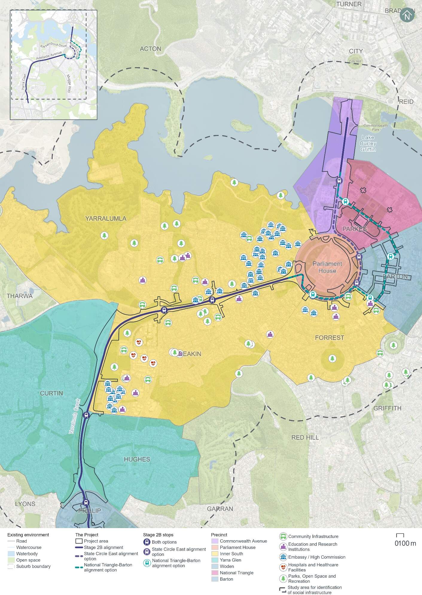
16.7.2 Potential impacts - construction
A summary of the potential socioeconomic impacts of the Project's construction for those living, working in, or visiting the Inner South precinct is provided in Table 16-42. Construction-phase socioeconomic impacts within the Inner South precinct would be common to both alignment options.
The significance of each impact has been evaluated taking into account its likelihood and magnitude, both before and after the implementation of proposed mitigation measures. The assessment approach is described further in Chapter 10 (Assessment methodologies) and Section 4 of Technical Report 6 - Socioeconomic.
The people most likely to be affected by change in this precinct would include those living in in the area near the Project area, and those in nearby offices that people are likely to occupy for eight hours a day. There are also some childcare centres and the Canberra Girls Junior School in this precinct that may be particularly sensitive to change.
Residents, workers and students provided feedback via online surveys and other consultation activities (which are described in Chapter 4 (Stakeholder and community consultation)), indicating that construction noise and vibration and traffic disruption are key community concerns. Participants expressed interest in how impacts would be mitigated, and several participants recognised that the construction impacts would be temporary and that the Project would deliver longer term benefits once operational.
Although some construction impacts remain rated as medium even after mitigation, impacts are predominantly temporary and would be minimised through the implementation of the mitigation measures identified in Table 16-42 and Chapter 21 (Environmental management and mitigation measures).
| Description of impact | Pre-mitigation impact (likelihood/ magnitude) | Mitigation approach | Mitigated impact (likelihood/ magnitude) |
|---|---|---|---|
|
Health and wellbeing Disruptions to local amenity during construction, potentially leading to a decline in health and wellbeing. This may particularly affect people with disabilities or chronic illnesses. Changes to local amenity to this precinct are assessed further in Section 16.1.2, Section 16.3, and Section 16.6 (in relation to traffic, noise and visual impacts, respectively). |
High (likely/ moderate) |
|
Medium (possible/ moderate) |
|
Disruptions to the road network and parking - impacts to road users Impact to road users due to temporary loss of about 60 on-street kerbside spaces including along Hopetoun Circuit, Kintore Crescent/Guilfoyle Street, and one bus zone on Denison Street. However, construction works are likely to be staged, so the temporary loss of on-street kerbside spaces across the precinct may be less at any given time during the construction program. Further detail on transport and access impacts within this precinct is provided in Section 16.1.2. |
Medium (likely/ minor) |
|
Low |
|
Disruptions to the road network and parking - impacts to accessibility for businesses, services, and workplaces Decline in accessibility to business and services due to temporary loss of on-street parking during construction, as described above. Further detail on transport and access impacts within this precinct is provided in Section 16.1.2. |
Medium (likely/ minor) |
Low |
|
|
Visual landscape and heritage Changes to vistas and surroundings of the Lodge by introducing construction activity and removal of trees, may affect those people visiting, working, or living in the area by diminishing their connection to place and shared histories. Further detail in landscape and visual impacts in this precinct is provided in Section 16.6. Further detail on impacts to heritage in this precinct is provided in Section 16.5. |
Low (possible/ moderate) |
|
Very Low (unlikely/ minor) |
16.7.3 Potential impacts - operation
A summary of the potential socioeconomic impacts of operation of the Project for those living, working in or visiting the Inner South precinct is provided in Table 16-42. Socioeconomic impacts within the Inner South precinct would be common to both alignment options.
Table 16-43 identifies socioeconomic impacts and evaluates the likelihood and magnitude of these impacts before and after the implementation of proposed mitigation measures. Where the impact is beneficial, this has been noted in Table 16-43. For beneficial impacts, measures which would enhance Project benefits have also been considered. The assessment approach is described further in Chapter 10 (Assessment methodologies) and Section 4 of Technical Report 6 - Socioeconomic.
Participants at consultation drop-in sessions, online feedback as well as many stakeholders' discussions indicated light rail operational benefits for the Precinct including support for active travel provisions and improved transport options for residents. Transport-related socioeconomic benefits would apply to people across the light rail corridor and are considered further in Chapter 11 (Project-wide issues).
| Description of impact | Pre-mitigation impact (likelihood/ magnitude) | Mitigation or enhancement approach | Mitigated impact (likelihood/ magnitude) |
|---|---|---|---|
|
Landscape and visual changes Permanent changes to local visual landscape may impact the community. While the introduction of light rail infrastructure would alter the road layout and tree arrangement, resulting in a potential adverse impact, key landscape features such as the linear avenue design and vegetative screening would be largely retained. Changes to the landscape and visual environment in this precinct are detailed in Section 16.6. |
Low (possible/ minor) |
|
Beneficial (possible/positive) |
|
Heritage and culture The Project would add new plantings on the median of Adelaide Avenue between State Circle and Hopetoun Circuit, which would partially obstruct views toward and outward from The Lodge. These changes may reduce people's connection to the area. Impacts to heritage are discussed further in Section 16.5. |
Low (possible/ minor) |
|
Beneficial (possible/positive) |
|
Access and mobility Enhanced accessibility and safety for pedestrians and cyclists, including those with mobility constraints through safety-related changes to active travel (e.g. signalised crossings and a new bridge to provide pedestrian and cyclist connections at Kent Street Stop). Refer to Section 5.8 of Chapter 5 (Project description) for further detail on active travel arrangements. |
Beneficial (possible/ positive) |
|
Beneficial (likely/positive) |
|
Operational noise Potential decline in social amenity and disruption to place of worship and educational services due to operational rail noise impacts at the Presentation Sisters Convent on Guilfoyle Street and Canberra Girls Junior School, respectively. Further detail on noise and vibration impacts in this precinct are detailed in Section 16.3. |
High (likely/ moderate) |
|
Medium (possible/ moderate) |
16.7.4 Precinct specific management and mitigation measures
Environmental management for this Project is detailed in Chapter 21 (Environmental management and mitigation measures). This includes construction and operational mitigation measures to manage noise and vibration impacts, that are applicable to the Project as a whole.
In addition to the Project-wide measures, mitigation measures to manage socioeconomic impacts in the Inner South precinct are shown in Table 16-40.
| ID | Objective | Management and mitigation measure | Timing |
|---|---|---|---|
|
SE4 |
Minimising socio-economic impacts through design |
The Project will consider opportunities to augment the community's sense of place and connection. As part of the Community Reference Group established for the project, local users of proposed grade separated stops will be engaged to provide input into the attractive, safe and efficient design that best meet the urban design drivers for the Project. |
Design and operation |