Environmental Impact Statement Chapter 5.0 Project description
Table of contents
Accessibility
This digital version of the EIS is designed to be accessible to all users, providing screen reader compatibility, keyboard navigation, and described images. If you require additional assistance or have specific accessibility needs, please contact us at lightrailtowoden@act.gov.au or call 1800 956 409.
5.0 Project description
This chapter provides a description of the Project, how it would operate and the urban design vision. The Project design presented in this chapter would be subject to ongoing development and the final design may vary from that presented in this chapter. A description of how the Project would be constructed is provided in Chapter 6 (Construction).
5.1 Overview
The Project would include the construction and operation (including maintenance) of the next stage of the Light Rail network, from the approved Light Rail Stage 2A (LRS2A) Commonwealth Park stop on Commonwealth Avenue, to a new terminus on Callam Street at Woden Town Centre (the Woden Interchange). The Project would be an extension of the existing Light Rail Stage 1 Gungahlin to City (LRS1) and the approved LRS2A.
A Commonwealth Joint Standing Committee (JSC) on the National Capital and External Territories inquiry into Commonwealth and Parliamentary approvals for Stage 2 of Canberra Light Rail was held in 2018 and 2019. The JSC Inquiry Report recommendations were agreed to, or agreed to in principle by the Australian Government. In response to the JSC recommendation that State Circle East had the in-principle support of the Commonwealth under the NCP, the ACT Government ultimately resolved to explore the preferred State Circle East alignment option through the EIS process, recognising that it provided a comprehensive pathway to understanding technical, environmental, and stakeholder issues. At the same time including an alternative alignment through the National Triangle and Barton meant that if the preferred option was not feasible, for whatever reason, the need to recommence the EIS process again with an alternative alignment would be avoided.
The following two alignment options are therefore being considered through the National Triangle and around Parliament House and are shown on Figure 5-1:
- The State Circle East alignment option: from Commonwealth Avenue along State Circle to Adelaide Avenue
- The National Triangle-Barton alignment option: from Commonwealth Avenue along King George Terrace, Macquarie Street, Bligh Street, National Circuit, and Sydney Avenue, before connecting with State Circle to Adelaide Avenue.
Only one of the two alignment options would be constructed. The selection of an alignment option for the Project (i.e. the National Triangle-Barton alignment option or the State Circle East alignment option) will consider factors including:
- Place outcomes
- Community and stakeholder feedback on the draft EIS
- Potential environmental and social benefits and impacts.
The revised, final EIS will describe only one alignment option, and will identify potential environmental impacts and benefits of that option.
The Project would provide light rail on Commonwealth Avenue, State Circle or King George Terrace towards Sydney Avenue (depending on the alignment option selected) then along Adelaide Avenue, Yarra Glen, and Callam Street as shown on Figure 5-1.
Both alignment options would connect at the Commonwealth Park Stop (approved as part of LRS2A) and would include nine new light rail stops. These new light rail stops are described in Section 5.4.
The Project would also include adjustments to the existing stabling and maintenance depot in Mitchell (the Mitchell Depot site) to increase storage and maintenance space for additional light rail vehicles(LRVs). Ancillary infrastructure and equipment required to operate the light rail would also form part of the Project, such as three new traction power substations (TPSs) (described in 5.10.3) and signalling equipment.
The Project would be subject to ongoing design development, as is typical of major infrastructure projects. This EIS includes a reasonable level of conservatism in its approach to assessing environmental impacts to accommodate anticipated design evolution. Potential refinements to the Project design are discussed in Section 5.14.
5.1.1 Precincts
This EIS has adopted a precinct-based approach for the environmental assessment of construction and operational impacts. The precinct-based approach responds to the linear nature of the Project, and the unique character, environmental and stakeholder context of areas along the Project alignment. The Project has been divided into seven precincts, as well as the Mitchell Depot site.
The State Circle East alignment option would be located within the Commonwealth Avenue, Parliament House, Inner South, Yarra Glen, and Woden precincts. The National Triangle-Barton alignment option would also be located within these precincts, as well as the National Triangle and Barton precincts.
Each precinct is shown on Figure 5-1.

A summary of the key features of the Project within each precinct is provided in Table 5-1, and shown on Figure 5-2 to Figure 5-17. Proposed road network changes to accommodate the Project are also shown in further detail on Figure 5-38 to Figure 5-52 (refer to Section 5.9).
| Description | Figure reference |
|---|---|
|
Commonwealth Avenue precinct |
|
|
The Commonwealth Avenue precinct comprises Commonwealth Avenue, extending from the Archbishop's House/Parkes Way in the north and ending just south of Coronation Drive in the south. For both alignment options the light rail would extend south from the approved LRS2A Commonwealth Park Stop, across Lake Burley Griffin and Flynn Drive via new light rail bridges. Within the Commonwealth Avenue precinct, light rail would be wire-free. State Circle East alignment option The light rail alignment would be located within the Commonwealth Avenue median within this precinct. It would include one light rail stop near Albert Hall, where a signalised pedestrian crossing would provide access to the stop from the verges. National Triangle-Barton alignment option The light rail alignment would transition from the median of Commonwealth Avenue to King George Terrace near the entrance to Hyatt Hotel Canberra. There would be no light rail stops within the Commonwealth Avenue Precinct for the National Triangle-Barton alignment option. |
Key features of the Project within this precinct are shown on Figure 5-2 (features common to both alignment options); Figure 5-3 (State Circle East alignment option) and Figure 5-6 (National Triangle-Barton alignment option). |
|
Parliament House precinct |
|
|
The Parliament House precinct sits generally within the National Triangle. The northern extent of the precinct begins on Commonwealth Avenue, immediately south of the intersection with Coronation Drive and extends around Parliament House to a point on Adelaide Avenue near its intersection with National Circuit. Within the Parliament House precinct, the light rail would be wire-free. State Circle East alignment option On Commonwealth Avenue, the light rail would transition from the road corridor into a dedicated covered section about 125 m long. This covered section would allow the light rail to pass underneath southbound Commonwealth Avenue traffic lanes through to State Circle (refer to Section 5.7). The light rail alignment would transition from the covered section onto the median of State Circle and pass around the eastern side of Capital Hill and Parliament House. To the west of Melbourne Avenue it would transition at-grade from median running on State Circle to transition onto Adelaide Avenue via the landscaped annulus between State Circle and Capital Circle and a new light rail bridge over State Circle (refer to Section 5.5.2) . For the State Circle East alignment option there would be three stops located within the median of State Circle: the Kings Avenue Stop, located immediately to the south of Kings Avenue; the Sydney Avenue Stop, located immediately to the north of Sydney Avenue and the Melbourne Avenue Stop, located immediately to the east of Melbourne Avenue. National Triangle-Barton alignment option Within the Parliament House precinct the National Triangle-Barton alignment option would transition onto State Circle at its intersection with Sydney Avenue. Until its transition onto Adelaide Avenue, this alignment option would run within the road verge (referred to as inner running) of State Circle. As with the State Circle East alignment option, this option would transition onto Adelaide Avenue via the landscaped annulus between State Circle and Capital Circle and a new light rail bridge over State Circle. The National Triangle-Barton alignment option would include one stop within this precinct, the Melbourne Avenue Stop, located on the inner verge of State Circle immediately east of its intersection with Melbourne Avenue. |
Key features of the Project within this precinct are shown on Figure 5-3 Figure 5-4, and Figure 5-5 for the State Circle East alignment option Figure 5-8, Figure 5-9, and Figure 5-10 for the National Triangle-Barton alignment option. |
|
National Triangle precinct |
|
|
This precinct is relevant to the National Triangle-Barton alignment option only. The National Triangle precinct encompasses the area generally between Commonwealth Avenue and Kings Avenue. Within the National Triangle precinct, the National Triangle-Barton alignment option would be located on King George Terrace and would be wire-free. There would be one light rail stop within this precinct (Treasury Stop), located at the intersection of King George Terrace and Langton Crescent. |
Key features of the Project within this precinct are shown on Figure 5-6 and Figure 5-7. |
|
Barton precinct |
|
|
This precinct is relevant to the National Triangle-Barton alignment option only. As shown on Figure 5-1 and Figure 5-8, the Barton precinct encompasses the area generally between Kings Avenue and Sydney Avenue, extending along Sydney Avenue from National Circuit to its intersection with State Circle. The light rail alignment would follow Macquarie Street, Bligh Street, National Circuit, and Sydney Avenue before connecting with State Circle. The National Triangle-Barton alignment option would include two stops in this precinct: the Bligh Street Stop located at the eastern end of Bligh Street and the Sydney Avenue Stop located at the south-eastern end of Sydney Avenue. Within the Barton precinct, the light rail would be wire-free. |
Key features of the Project within this precinct are shown on Figure 5-7 and Figure 5-8. |
|
Inner South precinct |
|
|
The Project design within this precinct would be consistent for both alignment options. The Inner South precinct comprises the extent of Adelaide Avenue generally between the intersection of Adelaide Avenue and National Circuit and the Adelaide Avenue/Cotter Road on- and off-ramps just south of Kent Street. The precinct would include a new light rail bridge between the existing Adelaide Avenue eastbound and westbound carriageways over Hopetoun Circuit. The precinct would also include two grade separated stops located in the median of Adelaide Avenue. The Hopetoun Circuit Stop would be located immediately to the west of Hopetoun Circuit, and the Kent Street Stop would be located immediately to the east of the Kent Street overbridge. At the Hopetoun Circuit Stop, the light rail would transition from wire-free running to use of over-head wiring. Over-head wiring would be adopted from this location through to the Woden Interchange. The precinct would also include a TPS (TPS 8), located off Guilfoyle Street within an existing grassed area. |
Key features of the Project within this precinct are shown on Figure 5-10, Figure 5-11, and Figure 5-12. |
|
Yarra Glen precinct |
|
|
The Project design within this precinct would be consistent for both alignment options. The Yarra Glen precinct comprises the Yarra Glen road corridor from south of Kent Street to the southern side of the Yarra Glen roundabout. The light rail alignment would predominately be located within the Yarra Glen median. The Project would include the reconfiguration of the Yarra Glen roundabout into a new at-grade intersection of Yarra Glen with Yamba Drive and associated at-grade crossing of this new intersection by light rail. A new light rail bridge over Yarralumla Creek would be provided. The existing active travel link would be relocated to the eastern side of Yarralumla Creek, and the existing Melrose Drive road bridge over Yarralumla Creek would be removed. The precinct would include one grade separated stop, the Carruthers Street Stop, located immediately to the south of Carruthers Street. Within the Yarra Glen precinct, the light rail would include over-head wiring. The precinct would also include a TPS (TPS 9) located off Yarra Glen, adjacent to the active travel link at the south-west corner of the Deakin Ovals. |
Key features of the Project within this precinct are shown on Figure 5-12, Figure 5-13, Figure 5-14, and Figure 5-15. |
|
Woden precinct |
|
|
The Project design within this precinct would be consistent for both alignment options. The Woden precinct extends from south of the Yarra Glen roundabout to around Neptune Street in Woden. From the southern extent of the Yarra Glen roundabout, the light rail alignment would continue south along the western side of Yarralumla Creek, across Launceston Street, along Callam Street, and terminating north of Bradley Street. The precinct would include two stops, the Phillip Oval Stop near Irving Street immediately north of Phillip Oval, and the Woden Interchange located on Callam Street between Bowes Street and Bradley Street. Within the Woden precinct, the light rail would include over-head wiring. The precinct would also include a TPS (TPS 10) in an existing carpark off Spoering Street near Phillip Oval. |
Key features of the Project within this precinct are shown on Figure 5-15 and Figure 5-16. |
|
Mitchell Depot site |
|
|
The existing Mitchell Depot site is used as a stabling, operational control and maintenance area for the existing Light Rail network and would be expanded to cater for the additional storage, operations and maintenance requirements to support the Project. |
Refer to Figure 5-17. |
5.1.2 Key Project infrastructure
A summary of the Project's key infrastructure features is provided in Table 5-2.
Key features of the Project are shown on Figure 5-2 to Figure 5-17. Proposed road network changes to accommodate the Project are also shown in further detail on Figure 5-38 to Figure 5-52 (refer to Section 5.9).
| Project feature | Description | |
|---|---|---|
| State Circle East alignment option | National Triangle-Barton alignment option | |
|
Light rail track (Section 5.3) |
A new light rail track around 9.5 kilometres (km) in length, connecting from the approved Commonwealth Park Stop (LRS2A), crossing over Lake Burley Griffin, travelling along the median of Commonwealth Avenue and passing on the eastern side of Parliament House in the median of State Circle. |
A new light rail track around 10.5 km in length, connecting from the approved Commonwealth Park Stop (LRS2A), crossing over Lake Burley Griffin, leaving Commonwealth Avenue to travel east along King George Terrace, Macquarie Street, Bligh Street, National Circuit, Sydney Avenue and moving to inner running on State Circle. |
|
From State Circle, both alignment options would transition onto Adelaide Avenue via the landscaped annulus between State Circle and Capital Circle before travelling along Adelaide Avenue and Yarra Glen, with a new terminus at Woden Town Centre (Woden Interchange). |
||
|
Light rail stops (Section 5.4) |
A total of nine new light rail stops and ancillary infrastructure. |
|
|
Bridges (Section 5.5) |
|
|
|
Covered section (Section 5.7) |
A covered section about 125 m long where the light rail would pass beneath the southbound lanes of Commonwealth Avenue and transition onto the median of State Circle. |
There would be no covered sections in the National Triangle-Barton alignment option. |
|
Active travel arrangements (Section 5.8) |
Reconfiguration, modification and/or replacement of existing active travel (walking, cycling and micromobility) infrastructure at various locations, and connection to existing active travel infrastructure within the Project area. New active travel arrangements would include four new pedestrian and cyclist bridges, shared paths to connect with the existing and/or planned active travel network, and bike/scooter parking at stops. |
|
|
Landscaping and public domain works (Section 5.2) |
Landscaping and public domain features along and around the Project alignment, as presented in the Public Domain Master Plan (refer to Appendix I). |
|
|
Road network changes (Section 5.9) |
Road network changes to accommodate the Project, including modifications to existing road carriageways and intersections, new intersection arrangements, changes to line markings and traffic signal phasing. |
|
|
|
|
|
Other facilities and infrastructure (Section 5.10) |
|
|
|
Operation and maintenance (Section 5.12) |
Operation and maintenance of the Project, including operation, storage and maintenance of up to 12 additional LRVs on the Light Rail network. |
|


5.2 Urban design approach
5.2.1 Key urban design drivers
Key urban design drivers have been identified for the Project to guide ongoing design and give effect to the Project's design vision. The key urban design drivers have been developed with reference to the Canberra: A Statement of Ambition 2016 (ACT Government, 2016) and the ACT Planning Strategy 2018 (ACT Government, 2018), with the aim to support the principles of sustainability, movement, place and landscape.
The key urban design drivers and corresponding objectives for each precinct are summarised in Table 5-3. They are described further in Appendix I (Public Domain Master Plan).
| Design driver | Objective |
|---|---|
|
Canberra's designed, historic urban landscape |
Complement the national significance of Canberra's historic urban plan The design should complement the ACT's ambition to optimise main avenues for multi-modal use and integration, and:
|
|
Sense of place |
Conserve and enhance the natural and planned landscape character of each precinct The Project should be designed to respond sensitively to the cultural, historic, and natural character of Canberra's landscape. A landscape-led approach to the design would reinforce the character in each distinct precinct within the light rail corridor. |
|
Design with Country |
Recognise Country and the connection Traditional Custodians have to place The Project should be developed to celebrate the rich heritage and living culture of Canberra. It should seek to incorporate First Nation's perspectives into design through engagement with traditional custodians in ways that can result in positive outcomes for Country, the land, built environment and community. |
|
Natural systems |
Protect and enhance natural systems Waterways that cross the Project should be sensitively managed through integration of water sensitive urban design principles. The Project should foster opportunities for biodiversity enhancement and increased tree canopy coverage. |
|
Connecting people to places |
Connect Canberrans to the places they live, work and play Light rail should connect people to neighbourhoods, schools, workplaces, and tourist destinations. Patterns of movement should be transformed by providing people with efficient and convenient access to precincts along the light rail corridor. |
|
Accessible and integrated Promote public transport use by enabling convenient multi-modal connections including walking, cycling, bus stops and other modes. Light rail stops should be accessible to all. |
|
|
Enhance cross-city connections The north-south light rail corridor should facilitate the establishment of cross-corridor links to local communities and improved city-wide connections. |
|
|
Connect Canberrans to the places they live, work and play Light rail should connect people to neighbourhoods, schools, workplaces, and tourist destinations. Patterns of movement should be transformed by providing people with efficient and convenient access to precincts along the corridor. |
|
|
People first |
Deliver comfortable, safe, and reliable public transport The safety and security, convenience, comfort, and passenger experience should be paramount in the planning, design and delivery of the Project. Light rail should provide public transport choice for Canberrans and a reliable passenger journey incorporating real time information and integrated ticketing systems. |
|
Placemaking |
Enhance local communities with complementary social infrastructure Light rail creates opportunities for urban renewal around stops and the broader corridor where appropriate. Increased patronage and activity around stops should support a mix of complementary uses and improve safety through passive surveillance and gender sensitive urban design. Public art should be included and informed by the landscape, heritage and the curated themes based on historical stories along the light rail corridor. |
|
High quality urban design and innovation |
Build beautiful, diverse, and layered places inspired by Country and precinct character High quality design and innovation is a key driver.The Project should consider high-quality, robust, and sustainable materials that are durable, low maintenance, and sensitively integrate into the surrounds. Well-designed stop canopies, street furniture, signage, lighting, and other urban elements define the system. These elements should guide intuitive wayfinding throughout corridor precincts and provide recognisable transport and urban infrastructure to enhance the public realm. |
|
Economy and technology |
Design for prosperity Light Rail to Woden should support key residential and employment hubs and provide opportunities for improved economic activity. |
|
Embrace technology and innovation Modernising the city's public transport system, the Project should embrace battery technology with wire-free running and green track. It should also consider emerging innovations in operations to enhance safety and improve the efficiency, sustainability, and performance of the system. |
|
|
Safeguard |
Inbuilt capacity for future generations The Project should be scalable to support the future urban densification of more homes, businesses and services along the corridor, and the expansion of light rail to other parts of the city. The Project should help maintain the city's liveability by enhancing public transport choice and access. |
|
Legacy |
Design to benefit Canberra's future generations Deliver a world-class integrated public transport system that benefits current and future Canberrans. The legacy of Light Rail to Woden would include improved accessibility, improved landscape, and pedestrian amenity, connected cycleways and increased tree canopy. |
5.2.2 Public Domain Master Plan
A Public Domain Master Plan has been prepared to outline the urban design vision for the Project. It identifies requirements and design approaches to achieve this vision, and to guide the planning, design development and delivery of the Project. It introduces the Project's precinct-based approach for identifying and addressing the diverse urban and landscape characteristics within the Project area.
The Public Domain Master Plan describes landscaping and public domain features designed to be consistent with the outcomes detailed in the NCP, and the Territory Plan, including:
- A landscape design-led approach to the Project that prioritises Canberra's landscape heritage, provides a positive landscape legacy where impacts are unavoidable, and meets the Project requirements
- Natural, cultural and indigenous heritage values, that are protected and addressed in the public domain
- Concept urban designs for the State Circle East and National Triangle-Barton alignment options
- Project light rail alignment, stops, and their interactions with interfacing road corridors and land uses
- Design and place opportunities for light rail integration within precincts
- Movement functions around the light rail alignment and stops, considering all users (pedestrians, cyclists, transit users, and road traffic)
- Light rail infrastructure that is well integrated within the existing public domain
- Guidance for the future design development of the Project
- The environmental and aesthetic objectives of the Project.
The Public Domain Master Plan is provided as Appendix I (Public Domain Master Plan). It may be subject to further review and refinement as part of the revised, final EIS.
5.2.3 Landscape strategy
A landscape strategy has been developed for the Project. It reflects Canberra's diverse range of landscape typologies which have been shaped by natural Country, the stewardship of the local Aboriginal peoples, the Griffin Plan and its legacy, the ongoing urban growth of the city, and its climate resilience.
The landscape strategy aims to fit the Project within the landscape typologies through which it would pass, minimising impacts to landscape character and views and celebrating the unique characteristics within each precinct. The strategy includes consideration of:
- The more formal landscape typologies within the northern Project precincts of Commonwealth Avenue, National Triangle, and Barton
- The more informal, 'natural' landscapes of the southern Project precincts of Inner South, Yarra Glen, and Woden
- Parliament House precinct, which displays a more informal, 'natural' landscape than its surrounding suburbs, particularly reflected in the native woodland buffer that occupies the lower slopes of Capital Hill
- Areas of ecological sensitivity, fauna habitats, threatened species and biodiversity
- The overlay of Designing with Country, which would embed an understanding and sense of Country within the landscape design response
- The health of trees and a consideration of vulnerability of species to climate change
- The increased use of native and endemic trees and planting where appropriate.
The Project landscape strategy is further detailed in Appendix I (Public Domain Master Plan).
5.2.4 Biodiversity Sensitive Urban Design
Biodiversity Sensitive Urban Design (BSUD) is an approach that integrates biodiversity into urban planning and development, viewing biodiversity as an opportunity rather than a limitation. It aims to mitigate the negative impacts of urbanisation, such as habitat loss and fragmentation, while promoting positive human-nature interactions.
BSUD considerations for the Project have included:
- Design development taking into account the need to protect the habitat for threatened fauna species, including the Golden Sun Moth (Synemon plana), Gang-gang Cockatoo (Callocephalon fimbriatum), and Superb Parrot (Polytelis swainsonii)
- Revegetation on the inner verge of State Circle to support habitat and biodiversity
- Increased tree density, creating a vegetated border adjacent the light rail corridor along Yarra Glen to reduce the risk of bird strike from low flying birds
- New trees and planting at all light rail stops to connect people to nature
- Increased tree and shrub planting from Yarra Glen, along Yarralumla Creek to Launceston Street to extend and connect natural areas
- Consideration of native tree planting across the Project to increase habitat for biodiversity, including the threatened Gang-gang Cockatoo and Superb Parrot.
5.2.5 Designing with Country
The land upon which the Project would sit is Ngunnawal Country. Canberra, derived from the local Aboriginal word for 'meeting place', has been home to the first peoples, the Ngunnawal, Ngambri and Ngambri-Guumaal for around 20,000 years. Ngunnawal, Ngambri, and Ngambri-Guumaal people continue to live and travel through the Canberra region, preserving their culture by maintaining connections to land and through artistic expression.
Aboriginal community members have been engaged to identify ways to incorporate Country and culture into the Project and Designing with Country. The Designing with Country stakeholder engagement process has included:
- Identifying traditional custodians, Representative Aboriginal Organisations (RAOs), and key organisations and broader community members, prioritising them according to seniority, cultural knowledge, and professional experience
- Conducting a Walk on Country and inviting priority stakeholders to a one-on-one interview process
- Gathering feedback and insights defining a site-specific Designing with Country Framework inclusive of key design principles.
Design themes and recommendations developed through this process are reflected in Appendix I (Public Domain Master Plan). The key design themes include:
- Reflect Country through landscaping - designing landscapes with a deep respect for the natural, cultural and spiritual dimensions of Country
- Journey through story telling - to use the Project as an opportunity for sharing stories as passengers are transported across Country
- Evoking the senses - Creating a multi-sensory experience to connect to Country, fostering a sense of belonging, identity and cultural heritage
- Incorporating language - opportunities include stop names, quick-response (QR) codes and signage to celebrate language in design.
Implementation of Designing with Country would occur over the next phase of design development, with continued community engagement and engagement of an Aboriginal design consultant to meaningfully consider key themes, an art strategy and socioeconomic recommendations within the design.
5.2.6 Gender sensitive urban design
To support the Project objective to enhance local communities with complementary social infrastructure, the Project has and would continue to consider gender sensitivity in design as a factor of overall customer experience, including safety and equitable access.
Gender sensitive urban design (GSUD) in the Project is guided by the GSUD Implementation Toolkit (ACT Government, 2021) and the Gender Sensitive Urban Design Framework (ACT Government, 2023) as well as a Project-specific design strategy.
GSUD recognises that people experience public spaces differently based on gender. GSUD seeks to empower the participation of everyone, particularly women, girls, and gender diverse people, in the use of public spaces, including public transport spaces. The application of design strategies which engage with the gendered experience of public space address themes including the enhancement of perceived safety and the promotion of inclusiveness, ensuring that public spaces are welcoming and accessible for all individuals.
While not all the experiences that contribute to how a person feels in a public space can be solved by design, a gender sensitive approach would seek to understand and embrace diversity and re-address inequalities in the design of the public realm to create more inclusive and equitable environments for everyone.
The Project has and would continue to include consideration of key GSUD elements within the context of public transport, including:
- Lighting - associated with stops
- Stop access - multiple points of access and good integration within their environs, including, where possible, catchment footpath upgrades
- Service information displays - good navigation, regardless of available personal technology, good communications with passengers
- Targeted consultation to inform the design approach, further supported by a women's safety audit.
Appendix I (Public Domain Master Plan) establishes the GSUD considerations to be applied across all precincts and to actively contribute to a more equitable and inclusive urban environment.
5.2.7 Connecting people to places
Connecting people to places by facilitating easy and effective transfer between different modes of transport, is a key driver for the Project. The Project would be designed to integrate with the broader transport network (including active travel networks and bus services) and would likely include the following features to allow passengers to change between transport modes:
- Wayfinding signage to direct passengers between public transport services
- Direct pathways to other public transport services and active travel routes
- Free-standing passenger information displays
- Bike/scooter parking at stops
- Kiss and ride.
An interchange facility with bus services on Callam Street (Woden Interchange) is currently under construction and will include future proofing for a light rail terminus as part of those works. The Project would include modification to the Woden Interchange to facilitate light rail operations and the ability for passenger interchange to/from bus services.
5.3 Light rail trackform and corridor
This section describes the different types of trackform and corridor arrangements along the light rail alignment. Trackform for the State Circle East alignment option would be around 9.5 km long, and around 10.5 km long for the National Triangle-Barton alignment option.
5.3.1 Trackform
Trackforms and their indicative locations are described in the following sections. The location of different types of trackform along the light rail alignment would be subject to further design development, taking into account community and stakeholder feedback, value for money, support for heritage outcomes and environmental, sustainability and landscaping outcomes.
At road intersections and on bridges, trackform would be an embedded track design to meet requirements for vehicles moving across the tracks.
Embedded track
Embedded track is typically used in street environments where the light rail track is trafficable by both LRVs and road vehicles. The embedded tracks would be encapsulated within a concrete base with the surface finish integrated to complement the surrounding context, function, and use. Different types of surface finishes are being considered for embedded track sections of the Project, such as concrete, paving, asphalt (generally at road intersections), stabilised decomposed granite gravel or (non-permeable) bonded gravel, and stone unit pavers. The Project would likely implement a mix of different surface finish types taking into account maintenance requirements, cost, local landscape context, urban design outcomes, and safety.
Figure 5-2 to Figure 5-16 show the embedded track locations for each alignment option. An example of embedded tracks installed as part of LRS1 is shown on Figure 5-18.

Green track
Green track is a light rail feature that includes grass or vegetation between and along tracks. Green track generally involves placement of the track on a plinth or base with a suitable fastening system.
As part of LRS2A, green track has been approved on Commonwealth Avenue on the northern side of Lake Burley Griffin (refer to Figure 5-19).

For the Project, the locations of green track are shown on Figure 5-2 to Figure 5-16 and summarised in Table 5-4. Different types of green track are being investigated for the Project and would be confirmed through ongoing design development. The Project would consider use of a combination of the following types of green track:
- Turf grass - which would comprise a monoculture turf grass with higher maintenance requirements compared to other green track options. An example of turf grass green track is shown on Figure 5-20
- Mass planted - which would comprise a mix of low ground cover species and gravel mulch, with medium to high maintenance requirements. An example of mass planted green track is shown on Figure 5-21.
The final design, type, and extent of green track would be subject to ongoing design development in consultation with stakeholders and may vary from the example images shown (including due to grass species selection). Green track design would consider factors including cost and maintenance requirements, the local landscape context, water use and sustainability. As part of ongoing design development, it may be appropriate, based on further consultation and consideration of the sustainability, whole of life considerations and landscape context, for some areas of green track to be treated with a permeable gravel material (refer to discussion on other potential trackforms in the following sections).


Other potential trackform types
Other potential trackform types would be considered along sections of Adelaide Avenue and Yarra Glen to the intersection at Melrose and Yamba Drive. These alternative trackform types could consist of concrete sleepers sitting on ballast and a suitable capping layer, and would be used only in areas where light rail is in a median with sufficient separation from the road, and with no intersections.
The Project may also include limited sections of permeable (gravel) track. This would comprise non-irrigated gravel mulch that would cover the rail sleepers and would have low to medium maintenance requirements.
The use of alternative trackform types would be subject to further investigation and would consider factors such as urban design and place integration, value for money (considering both construction and operational maintenance costs), drainage, and sustainability outcomes.
5.3.2 Light rail corridor
The light rail corridor refers to the land and physical structures (e.g. track and light rail stops) on which LRVs would operate. For the majority of the Project, the light rail corridor would be located within existing road reserves, and separated from other vehicles by a kerb or other physical barrier. In this configuration, the tracks could be located either:
- Within a median (referred to as 'median running'). An example of this is shown on Figure 5-22
- Within the road verge (referred to as 'inner running'). An example of this is shown on Figure 5-23.
In both median and inner running arrangements, LRVs would generally not use the same road space as road vehicles, except at intersections where LRVs would cross the road carriageway via controlled traffic signals. Key exceptions to this are noted in Table 5-4. Pedestrians would be able to cross the tracks and road carriageway via traffic signals or other designated crossing points.


There are some instances where the light rail corridor would be located outside of a road reserve:
- In respect of both alignment options:
- A section of the light rail alignment between State Circle and Capital Circle, within the Parliament House precinct (refer to Figure 5-10 and Figure 5-24). This section of the light rail alignment is within land designated for roads, however is located physically away from road carriageways
- A section of the light rail alignment south of the Yarra Glen/Melrose Drive/Yamba Drive intersection to Launceston Street in the Woden precinct. This section is on Territory land where light rail is permissible in the Territory Plan (refer to Figure 5-15, Figure 5-16 and Figure 5-25).
- For the National Triangle-Barton alignment option: A section of the light rail alignment between Commonwealth Avenue and Langton Crescent, connecting to the Treasury Stop (refer to Figure 5-6). This section would traverse the Commonwealth Avenue and National Triangle precincts.


5.3.3 Light rail trackform and corridor across precincts
A summary of the indicative light rail trackform types within each precinct, including the light rail corridor type is provided in Table 5-4 and shown on Figure 5-2 to Figure 5-16.
| Trackform | Light rail corridor type |
|---|---|
|
Commonwealth Avenue precinct |
|
|
Median running. |
|
Parliament House precinct |
|
|
State Circle East alignment option
|
State Circle East alignment option Median running, with the exception of an inner running section where the light rail transitions from State Circle onto Adelaide Avenue via the landscaped annulus between State Circle and Capital Circle. |
|
National Triangle-Barton alignment option Green track - road verge along State Circle, just west of the Sydney Avenue Stop, to Adelaide Avenue, and Capital Hill. |
National Triangle-Barton alignment option Inner running. |
|
National Triangle precinct (National Triangle-Barton alignment option only) |
|
|
Median running, with the exception of a section of the alignment between Commonwealth Avenue and Langton Crescent where the alignment is located away from the road reserve. |
|
Barton precinct (National Triangle-Barton alignment option only) |
|
|
Median running, with the exception of a controlled section of the alignment on Bligh Street between Macquarie Street and the Bligh Street Stop, where the alignment would also be used by road vehicles accessing No 6 National Circuit and No 4 Bligh Street. |
|
Inner South precinct |
|
|
Median running. |
|
Yarra Glen precinct |
|
|
Embedded track. |
Median running. |
|
Woden precinct |
|
|
Embedded track. |
Median running, with the exception of the light rail alignment between the Yarra Glen/Melrose Drive/Yamba Drive intersection and Launceston Street which would be outside of the road reserve |
5.4 Light rail stops
5.4.1 Stop locations and platform arrangements
Both alignment options would include nine new stops. Light rail stop locations are shown on Figure 5-2 to Figure 5-16. Stop platforms may either be a side platform arrangement (two platforms located either side of narrow tracks, refer to Figure 5-26), or an island platform arrangement (a single central platform between tracks, refer to Figure 5-27).
Further investigations into potential urban renewal opportunities are being carried out by others as part of development of the Southern Gateway Planning and Design Framework. This framework outlines the strategic directions for growth and development in the Inner South and Woden districts, including integrated land-use and transport outcomes in and around Yarra Glen and North Woden. To support planned land-use outcomes, the Project design does not preclude the introduction of a potential future stop within the Yarra Glen median near the Royal Australian Mint.


Platform dimensions for light rail stops have been informed by anticipated customer requirements, existing infrastructure and space constraints, platform typology and integration with other Project infrastructure (e.g. bridges). Stop platforms would generally range from 33 to 45 m long, with space proofing at shorter platforms (33 m) to allow for potential future expansion to 45 m if required in the future. Table 5-5 summarises the indicative stop platform arrangements and dimensions for the Project.
| Stop name | Alignment option | Location | Indicative platform arrangements (at commencement of operation) | ||
|---|---|---|---|---|---|
| Type | Length (m) | Width (m) | |||
|
Commonwealth Avenue precinct |
|||||
|
Albert Hall |
State Circle East alignment option only |
In the median of Commonwealth Avenue, just north of Albert Hall. |
Island platform |
45 |
5.5 |
|
Parliament House precinct |
|||||
|
Kings Avenue |
State Circle East alignment option only |
In the median of State Circle, south of the intersection with Kings Avenue, opposite to York Park. |
Island platform |
45 |
5.5 |
|
Sydney Avenue |
State Circle East alignment option only |
In the median of State Circle, north-east of the intersection with Sydney Avenue and State Circle. |
Island platform |
45 |
5.5 |
|
Melbourne Avenue |
State Circle East alignment option only |
In the median of State Circle, east of the intersection with Melbourne Avenue and State Circle (in the median). |
Island platform |
45 |
5.5 |
|
Melbourne Avenue |
National Triangle-Barton alignment option only |
In the inner verge of State Circle, east of the intersection with Melbourne Avenue and State Circle (in the inner verge). |
Side platforms |
45 |
4.5 |
|
National Triangle precinct |
|||||
|
Treasury |
National Triangle-Barton alignment option only |
On King George Terrace at the intersection with Langton Crescent. |
Side platforms |
45 |
4.0 |
|
Barton precinct |
|||||
|
Bligh Street |
National Triangle-Barton alignment option only |
On the western end of Bligh Street, close to the intersection with National Circuit. |
Side platforms |
45 |
3.5 |
|
Sydney Avenue |
National Triangle-Barton alignment option only |
In the median of Sydney Avenue, between Windsor Walk and National Circuit. |
Side platforms |
45 |
4.0 |
|
Inner South precinct |
|||||
|
Hopetoun Circuit |
Both alignment options |
In the median of Adelaide Avenue, immediately west of Hopetoun Circuit. |
Island platform (grade-separated) |
33 |
6.0 |
|
Kent Street |
Both alignment options |
In the median of Adelaide Avenue, east of Kent Street overpass bridge. |
Island platform (grade-separated) |
33 |
8.0 |
|
Yarra Glen precinct |
|||||
|
Carruthers Street |
Both alignment options |
In the median of Yarra Glen, south of the Carruthers Street overpass bridge. |
Island platform (grade-separated) |
33 |
8.0 |
|
Woden precinct |
|||||
|
Phillip Oval |
Both alignment options |
North of Phillip Oval, near Irving Street on western side of Yarralumla Creek. |
Side platforms |
45 |
4.0 |
|
Woden Interchange |
Both alignment options |
On Callam Street, north of the intersection with Bradley Street. |
Side platforms |
45 |
4.0 |
The Hopetoun Circuit Stop and Kent Street Stop on Adelaide Avenue, and Carruthers Street Stop on Yarra Glen would be grade-separated due to the difference in level between the light rail alignment and the parallel road network. Indicative visualisations of these grade-separated stops at Kent Street and at Hopetoun Circuit are provided on Figure 5-28 and Figure 5-29, respectively.


Consultation with key stakeholders and the community, including the established Community Reference Group for the Project, would continue as part of ongoing optimisation of stop design. This process would include consideration of designs that provide attractive, safe and efficient stops and best meet the urban design drivers for the Project (refer to Section 5.2).
The design of the Phillip Oval Stop would be subject to further investigation to improve resilience to potential flooding along Yarralumla Creek. This may include adjustments in the location and height of infrastructure at or near this stop.
5.4.2 Stop architecture
To maintain legibility and consistency with LRS1 and LRS2A, and to assist with intuitive wayfinding, the architectural design of the stops across all precincts would be generally consistent with the existing LRS1 stops, and approved LRS2A stops. In particular, the Albert Hall Stop (State Circle East alignment option) would be designed to maintain visual consistency with other approved LRS2A stops along Commonwealth Avenue. The Public Domain Master Plan (refer to Section 5.2.2 and Appendix I (Public Domain Master Plan)) identifies requirements and design principles for stop architecture which acknowledge the heritage landscape and values around stop locations.
5.4.3 Accessibility
Stops would be designed to meet Australian Standard AS1428: Design for access and mobility, and the requirements of Disability Standard Accessible Public Transport (DSAPT) issued under the Disability Discrimination Act 1992 (Cth) (DDA). Stops would include infrastructure for accessibility, including:
- Passenger ramps and handrails
- Seating at stops, including space provisions for wheelchairs in some areas
- Facilities at grade-separated stops to assist with access to the platform such as lifts and stairs
- Braille lettering and raised pictograms at stops, on information totem poles, and on every LRV door button
- Pre-recorded public announcement messaging to assist hearing impaired passengers with information about the stop facilities
- Hearing loops at each stop and on-board LRVs to assist those with hearing impairments
- Accessibility symbols and tactile ground surface indicators on the ground of stop platforms for mobility aid users to assist with boarding.
Stops would be designed to be accessible from a suitable access point. Access to at-grade platforms would be from signalised crossings and ramps where necessary. Grade-separated stops would have lifts and stairs to allow access to the platform. Signalised pedestrian crossings would also be provided at stops with a side platform arrangement, to allow passengers to cross the tracks safely.
At some stops such as the Phillip Oval Stop and the Bligh Street Stop, platforms would be integrated into the surrounding footpath (i.e. designed at a similar level with visually similar materials to the surrounding footpath) to allow seamless access. This arrangement would be similar to the existing Gungahlin terminus, as shown on Figure 5-30.

5.4.4 Safety and security
The Project design would incorporate measures to promote the safety of light rail passengers and staff. Crime prevention through environmental design (CPTED) principles and Gender Sensitive Urban Design (GSUD) initiatives (refer to Section 5.2) have been integrated into the design.
The Project would be designed, constructed and operated in accordance with the Rail Safety National Law. Safety features incorporated into the design would include:
- Installation of closed-circuit television (CCTV)
- Provision of clear signage and public address system to assist in an emergency
- Designing stops with clear sight lines for passengers and staff for passive surveillance
- Installation of lighting
- Reinforcement of the light rail stop boundaries to separate the road reserve from stops where space allows using landscape design and other design features such as signalised crossings
- Emergency help points located at every LRV door and at each stop
- Potential use of bollards to delineate areas, the location and extent of which would be subject to ongoing design development
- Dual access/egress to stops where possible as well as clearly marked exits.
The Project design has also been developed to be responsive to the security and access requirements for high security buildings, particularly around the Parliament House, National Triangle and Barton precincts. The Project concept design has been, and would continue to be developed in consultation with these stakeholders to manage potential conflicts with existing security requirements, and to avoid any increase in security and access risks.
Security is discussed further in the hazard and risk assessment in Section 11.13 of Chapter 11 (Project-wide issues).
5.4.5 Stop furniture and facilities
The design of stop furniture and facilities would be generally consistent with those provided for LRS1 and approved for LRS2A. Stop furniture and facilities would include canopies, windbreak screens, emergency help points, customer information points, seating, water fountains, and rubbish bins.
Other key furniture and facilities at stops would include access points, CCTV, lighting, canopies, furniture, signage, tactile ground surface indicators (TGSIs), radio masts, cabinets for signalling, bicycle parking and other customer facilities (e.g.passenger information display systems, hearing loops, and ticket machines).
Driver facilities would also be provided at the Woden Interchange and would be similar in nature to those provided at the Alinga Street Stop as part of LRS1.
5.4.6 Signage and wayfinding
The Project would incorporate a dedicated signage system that has been implemented as part of LRS1 and approved for LRS2A. Signage at stops would generally include stop names, wayfinding, warning signs, timetable information, and customer information points.
Signage and wayfinding would be designed to be intuitive, clear, and consistent to enhance customer journeys. Urban design elements such as stop canopies, street furniture and lighting would support intuitive wayfinding for customers within all precincts.
Operational signage would also be in use by the light rail operator and drivers, such as light rail speed limit signage.
5.5 Bridges
The Project would require the construction of new light rail and pedestrian and cyclist bridges, and the removal and modification of existing road vehicle and pedestrian and cyclist bridges.
New light rail bridges would facilitate grade separated travel along the light rail alignment and would allow connection to each light rail stop. New pedestrian and cyclist bridges would be required to connect to existing and new active travel arrangements. Active travel arrangements for the Project are described further in Section 5.8.
The following existing bridges would be removed as part of the Project:
- Road bridge over Yarralumla Creek between Yamba Drive and Melrose Drive
- Pedestrian bridge across Yarralumla Creek north of Phillip Oval.
New and modified bridges (including light rail, pedestrian and cyclist, and road vehicle bridges) required as part of the Project are summarised in Table 5-6. Each bridge identified in Table 5-6 would be required for both alignment options.
| Location / details of bridge | Approximate length (metres) |
|---|---|
|
Commonwealth Avenue precinct |
|
|
New light rail bridge over Lake Burley Griffin between the existing Commonwealth Avenue northbound and southbound road bridges. The light rail bridge would allow for northbound and southbound direction travel. |
330 |
|
New light rail bridge over Flynn Drive between the existing Commonwealth Avenue road bridges. |
65 |
|
Parliament House precinct |
|
|
New light rail bridge over State Circle between the existing Adelaide Avenue northbound and southbound carriageways. The light rail bridge would allow for northbound and southbound direction travel. |
65 |
|
Inner South precinct |
|
|
New light rail bridges over Hopetoun Circuit between the existing Adelaide Avenue road bridges. |
55 |
|
New pedestrian and cyclist bridge parallel to the existing Kent Street bridge over Adelaide Avenue. |
60 |
|
Yarra Glen precinct |
|
|
New pedestrian and cyclist bridge parallel to the existing Carruthers Street bridges over Yarra Glen. |
70 |
|
Modification (including widening) of the existing Melrose Drive road bridge over Yarralumla Creek. |
20 |
|
New light rail bridge over Yarralumla Creek, immediately south of the new intersection at the Yarra Glen/Melrose Drive/Yamba Drive interchange. To the south of the intersection, a new light rail (only) bridge would be provided to allow the light rail alignment to pass from the eastern to the western side of Yarralumla Creek. The light rail bridge would allow for northbound and southbound direction travel. |
50 |
|
Woden precinct |
|
|
New pedestrian and cyclist bridge over Yarralumla Creek to the east of Ivy Apartments to connect the new active travel link (on the eastern side of Yarralumla Creek) with the Phillip Oval Stop |
20 |
|
New pedestrian and cyclist bridge on the eastern side of Yarralumla Creek crossing over the Yarralumla Creek Main Drain to connect the active travel link through to Canberra College and Launceston Street |
20 |
5.5.1 Commonwealth Avenue light rail bridges
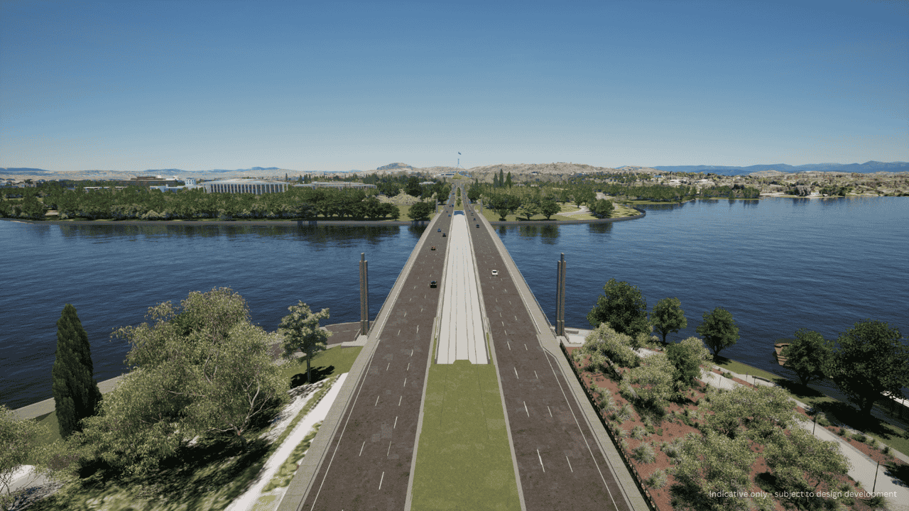
Two light rail bridges would be provided between the existing Commonwealth Avenue road bridges over Lake Burley Griffin, and Flynn Drive. These two bridges have been and would continue to be designed in line with the following principles:
- Be of equal quality to that of the existing road bridges
- Have the same column spacing as the existing road bridges
- Not reduce existing lake to underside of bridge clearance distances
- Be slimmer than the existing bridges so as not to visually impact the existing road bridges
- Have no impact on the structural soundness of the existing road bridges.
Figure 5-31 and Figure 5-32 provide indicative visualisations showing the light rail bridges over Lake Burley Griffin and Flynn Drive, respectively. The location of the bridges is shown on Figure 5-2.
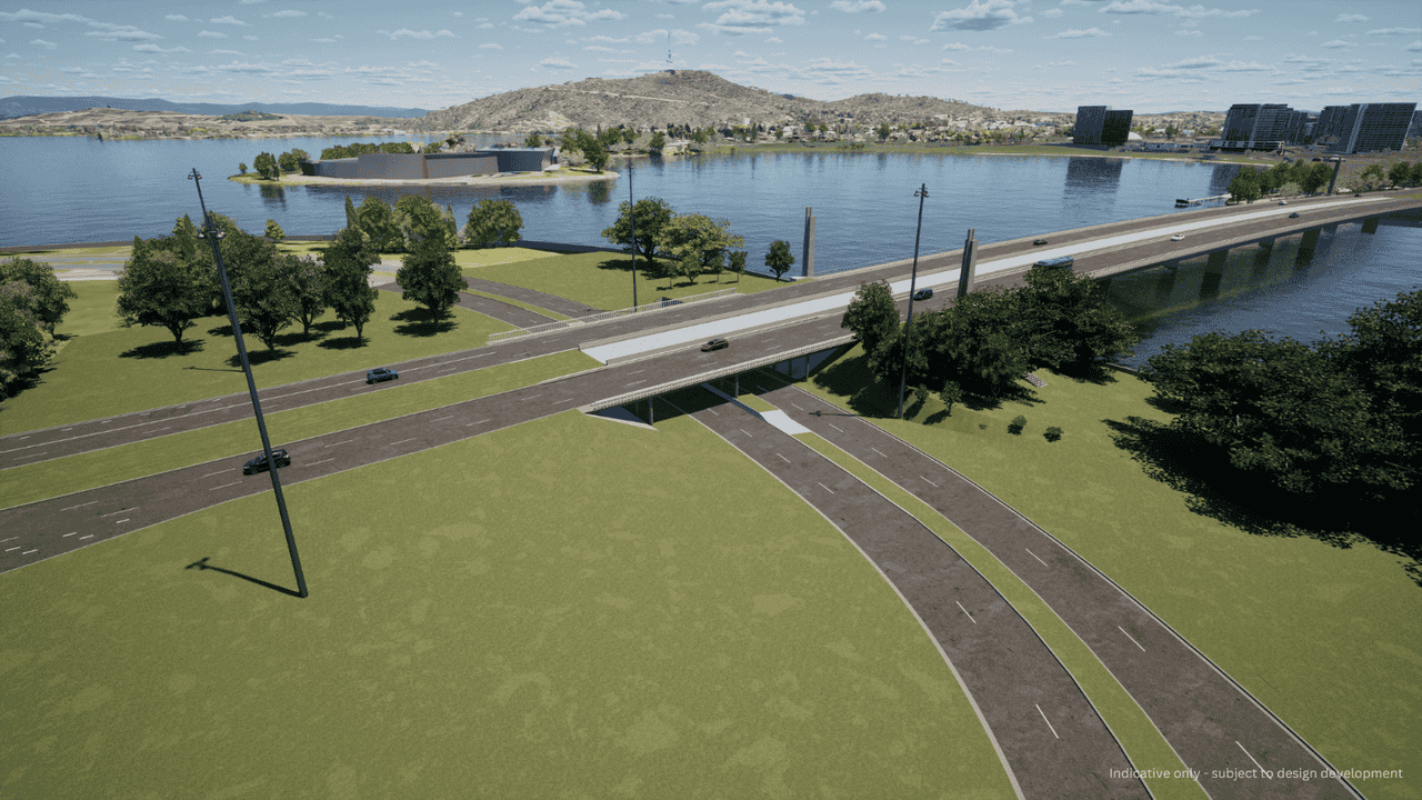
5.5.2 Adelaide Avenue light rail bridge over State Circle
The light rail alignment would transition from State Circle onto Adelaide Avenue via the landscaped annulus between State Circle and Capital Circle, an at-grade intersection with Capital Circle, and a light rail bridge over State Circle between the existing Adelaide Avenue road bridges. An indicative visualisation is provided on Figure 5-33, and the location of the light rail bridge is shown on Figure 5-5 and Figure 5-10.

5.5.3 Twin light rail bridges over Hopetoun Circuit
Twin bridges would be provided over Hopetoun Circuit for the northbound and southbound light rail tracks. The location of these bridges is shown on Figure 5-11, with an indicative visualisation of the bridges provided on Figure 5-34.

5.6 Melrose Drive and Yamba Drive intersection and light rail bridge
The Melrose Drive and Yamba Drive roundabout would be removed and replaced with a new signalised high capacity intersection. The new intersection would allow for light rail movement, improved traffic flow, and would include the following key infrastructure:
- A new light rail bridge over Yarralumla Creek
- Modification to the existing Melrose Drive road bridge over Yarralumla Creek to accommodate the southbound carriageway comprising two through traffic lanes
- Removal of the existing road connection from Yamba Drive to Melrose Drive, including the removal of the existing road bridge
- Removal of existing pedestrian and cyclist bridge over Yarralumla Creek, and construction of new pedestrian and cyclist bridge further south
- Relocation of the existing active travel link to the eastern side of Yarralumla Creek.
Melrose Drive and Yamba Drive intersection locality is identified as a 'change area' in the District Strategies and is the subject of ongoing strategic planning investigations as part of the Southern Gateway Planning and Design Framework. Noting the ongoing planning work, an indicative visualisation of the intersection and light rail bridge is provided on Figure 5-35. Its location is shown on Figure 5-15.

5.7 Covered section between Commonwealth Avenue and State Circle
For the State Circle East alignment option, the light rail alignment would travel along the Commonwealth Avenue median and transition under the southbound carriageway of Commonwealth Avenue to emerge on State Circle via a covered section around 125 m long. The covered section would not be accessible to road vehicles, pedestrians or other active travel users.
This covered section would allow the light rail alignment to transition from Commonwealth Avenue to State Circle without disrupting traffic. It would also minimise visual impacts relative to at-grade or overpass alternatives. Indicative visualisations of this covered section are provided on Figure 5-36 and Figure 5-37. The location of the covered section is shown on Figure 5-3.
LRVs would enter and exit the covered section from an opening in the median of Commonwealth Avenue, south of the Coronation Drive and Queen Victoria Terrace intersection with Commonwealth Avenue (shown on Figure 5-36), and an opening on the north side of State Circle, east of Commonwealth Avenue (shown on Figure 5-37).
Services such as fire and life safety equipment, lighting, cables, CCTV, signage and infrastructure to support light rail operations would be provided for the covered section.
To manage potential surface water and groundwater entry, the covered section may include drainage and water management infrastructure such as a wet well, in-built subsoil drainage, recessed pumps, a valve pit and rising main, and water treatment equipment.
Opportunities to minimise the complexity of the design of the covered section, including potential at-grade options, would be subject to further investigations and consultation with key stakeholders. Any alternative solution would balance factors including traffic and road network performance, urban design and visual impacts, and heritage considerations.


5.8 Active travel arrangements
Active travel arrangements for the Project, such as access to light rail stops and long-term transport and land use integration, have been considered in relation to the existing cycling and pedestrian network and the Active Travel Plan 2024-2030 (ACT Government, 2024).
For much of the Project, the existing active travel arrangements would be retained. However, to promote more continuous active travel links through the area, new active travel infrastructure as part of the Project would include:
- Four new pedestrian and cyclist bridges (as discussed in Table 5-6)
- Shared paths to connect with the existing and/or planned active travel network
- Bike/scooter parking at stops
- Modifications to existing active travel pathways (such as on-road cycleways, off-road shared pathways and dedicated off-road cycleways) to integrate with the Project.
The National Triangle-Barton alignment option would include active travel links through the National Triangle and Barton precincts, enhancing access to national cultural institutions, commercial areas, hotels and government offices.
A summary of active travel arrangements provided by the Project in each precinct is provided in Table 5-7. There would be no change to active travel arrangements around the Mitchell Depot site.
| Active travel arrangements |
|---|
|
Commonwealth Avenue precinct |
|
State Circle East alignment option only Other than adjustments to kerb lines at the Coronation Drive intersection area, existing active travel arrangements on Commonwealth Avenue (on road cycleways) would be retained and would remain unchanged. National Triangle-Barton alignment option only The existing Commonwealth Avenue southbound on-road cycle lane would be diverted to allow safe crossing of the track as it crosses from the Commonwealth Avenue median across the verge through the landscaped area and onto King George Terrace. |
|
Parliament House precinct |
|
State Circle East alignment option only There are no dedicated cycleways or on-street cycle markings on State Circle. These existing active travel arrangements on State Circle would remain unchanged, however a minor adjustment would be required to allow for safe crossing of the light rail alignment as it enters State Circle from the covered connection from Commonwealth Avenue. National Triangle-Barton alignment option only Existing active travel arrangements would remain unchanged. |
|
National Triangle precinct |
|
National Triangle-Barton alignment option only A shared path would be provided on the northern side of the light rail alignment between Commonwealth Avenue and Parkes Place West running parallel to the new Treasury Stop |
|
Barton precinct |
|
National Triangle-Barton alignment option only A shared path would be provided between Kings Avenue and Bligh Street on the eastern verge of Macquarie Street. Existing on-road dedicated cycle lanes on National Circuit would be replaced with a shared path between Bligh Street and Sydney Avenue on the western verge of National Circuit. Active travel arrangements would be provided to connect to and around the Bligh Street Stop and Sydney Avenue Stop and would include facilities for cyclist/scooter parking. |
|
Inner South precinct |
|
Both alignment options Existing on-road cycleways on Adelaide Avenue would be retained. Minor modifications to these cycleways would be required at the upgraded intersections located at the on- and off-ramps with Adelaide Avenue and Hopetoun Circuit. Bicycle parking and storage would be provided at the new public plaza on Hopetoun Circuit (proposed as part of the Project). A new pedestrian and cyclist bridge would provide pedestrian and cyclist connections at the Kent Street Stop (refer to Section 5.5). Stop access plazas would be provided at each end of the new bridge and would include bicycle parking and storage. |
|
Yarra Glen precinct |
|
Both alignment options Existing on road and off-road cycle paths would be retained. A new pedestrian and cyclist bridge would provide pedestrian and cyclist connections at the Carruthers Street Stop (refer to Section 5.5). Stop access plazas would be provided at each end of the new bridge and would include bicycle parking and storage. Existing active travel arrangements would be reconfigured and consolidated onto the eastern side of Yarralumla Creek. |
|
Woden precinct |
|
Both alignment options The light rail alignment and Phillip Oval Stop would be located on the western side of Yarralumla Creek. The existing active travel arrangements (shared path) on the western side of Yarralumla Creek would be consolidated onto the eastern side of the creek, as shown on Figure 5-16. A section of this new active travel path would be on an elevated structure, extending north and south around the Phillip Oval Stop area. This elevated path would provide connection to the following two pedestrian and cyclist bridges:
The existing pedestrian bridge across Yarralumla Creek north of Phillip Oval would be removed, and the existing pedestrian and cycle bridge over Yarralumla Creek north of Launceston Street would be retained. |
The EIS considers the ACT Government's Active Travel Plan 2024-2030, which identifies a future walking and cycling network, including a more direct cycle route between the City and Woden within the Inner South precinct.
Investigations into the feasibility of an Adelaide Avenue and Yarra Glen cycleway have identified a potential alignment for a future shared path link along these road corridors. Some elements of this shared path will be progressed outside of this EIS process, as an allied or related project(s) with separate approvals. The Project has considered and would not preclude future development of cycling infrastructure along Adelaide Avenue and Yarra Glen. iCBR will continue to work with ACT Government stakeholders to coordinate active travel infrastructure along the corridor.
5.9 Road network changes
The Project would require consequential modifications to the surrounding road network, including changes to the physical configuration of the network and changes to posted speed limits.
5.9.1 Changes to the configuration of the road network
The Project would generally be delivered within existing roadways or road reserves. To facilitate this, changes to the existing road network would be necessary to accommodate the light rail tracks and stops. These road network changes would include road realignments and closures, adjustments to existing lanes, intersections and access arrangements, adjustments to property access, and some changes to speed limits. Key road network changes are summarised in Table 5-8 to Table 5-10 and shown on Figure 5-38 to Figure 5-52. There would be no road network changes around the Mitchell Depot site. Temporary changes to the road network during the construction of the Project are described in Section 6.7 of Chapter 6 (Construction).
The road network changes have been developed to safely and effectively integrate new light rail infrastructure and operations into the existing road network while also reducing impacts on existing trees, urban vistas and streetscapes. The Project design supports operational safety by including dedicated light rail running (avoiding areas where road vehicles and LRVs share road space), reduction of road vehicle speed limits on some roads, changes to intersection arrangements including changes to available turning movements, and additional pedestrian safety measures such as reduced speed limits, increased crossing times and/ or new or staged pedestrian crossings to support access to light rail stops.
For the National Triangle-Barton alignment option, road closures in the National Triangle and Barton precincts would be implemented to allow space for the light rail alignment. Closure of roads in these precincts has been adopted rather than widening or realigning roads to avoid and minimise impacts to the highly sensitive heritage landscape and individual heritage items such as Old Parliament House and the Kurrajong Hotel. Consequential changes to some site access arrangements in these precincts (including relocations and conversion to left-in, left-out arrangements) would also be made to minimise potential interactions between road traffic and LRVs.
Notwithstanding changes to the road network required to facilitate the Project, road users would continue to be able to access destinations in much the same way as is currently allowed for by the existing road network. There would be no change in access for those travelling to or between major centres. In some instances (predominantly for local access arrangements) block closures and median islands would result in minor changes to local access routes. Impacts of changes to the road network are assessed in Technical Report 1 - Traffic and transport, and traffic assessment sections in Part B (Environmental Impact Assessment).
Where the Project would result in changes to existing traffic arrangements, adjustments to or additional road signage and line marking would be required. Except for speed limit signs, road and light rail signage would be co-located where possible on multi-use poles. The location of light rail signage would be coordinated with traffic signal locations at intersections and would be located adjacent to the light rail track. The required clearance distance would be maintained to allow LRV movements within the light rail alignment.
In addition to the road network changes summarised in Table 5-8 to Table 5-10, adjustments along State Circle into Capital Hill would be required to accommodate light rail infrastructure, as described below.
For the State Circle East alignment option:
- Realignment of the inner carriageway of State Circle into Capital Hill by up to around 20 m to accommodate the light rail median running arrangement, generally between Commonwealth Avenue and Adelaide Avenue
- Realignment into Capital Hill would be greater at intersections along State Circle to accommodate existing turning movements (by up to around 25 m at Canberra Avenue and by up to around 28 m near Melbourne Avenue).
For the National Triangle-Barton alignment option:
- Introduction of light rail infrastructure into Capital Hill by up to around 22 m to accommodate the inner running arrangement, generally between Sydney Avenue and Adelaide Avenue
- This would be greater at intersections along State Circle to accommodate the light rail infrastructure (by up to around 35 m at Sydney Avenue, by up to around 27 m at Canberra Avenue and by up to around 29 m near Melbourne Avenue).
Further design development would also include consideration of opportunities and constraints associated with light rail running arrangements on State Circle, including an inner running arrangement for the State Circle East alignment option.
| Location | Existing arrangements | Proposed arrangements |
|---|---|---|
|
Commonwealth Avenue precinct - State Circle East alignment option |
||
|
Intersection of Commonwealth Avenue and Albert Street (refer to Figure 5-38) |
Existing conditions based on LRS2A design:
|
|
|
Commonwealth Avenue between the approved LRS2A Commonwealth Park Stop and Coronation Drive (refer to Figure 5-38 and Figure 5-39) |
|
|
|
Intersection of King Edward Terrace/ Flynn Drive ramps and Commonwealth Avenue (refer to Figure 5-38 and Figure 5-39) |
|
|
|
Intersection of Commonwealth Avenue, Coronation Drive and Queen Victoria Terrace (refer to Figure 5-39) |
|
A signalised intersection with:
|
|
Parliament House precinct - State Circle East alignment option |
||
|
Commonwealth Avenue between Coronation Drive and State Circle (refer to Figure 5-39) |
|
|
|
Exit ramp from Commonwealth Avenue to State Circle (refer to Figure 5-39) |
|
|
|
Intersection of State Circle and exit ramp from Commonwealth Avenue (refer to Figure 5-39) |
|
|
|
State Circle between exit ramp from Commonwealth Avenue and Brisbane Avenue (refer to Figure 5-39 and Figure 5-40) |
|
|
|
Intersection of State Circle and Kings Avenue (refer to Figure 5-40) |
|
|
|
Intersection of State Circle, Brisbane Avenue, and Wyman Street (refer to Figure 5-40) |
|
|
|
State Circle between Brisbane Avenue and Canberra Avenue (refer to Figure 5-40) |
|
|
|
Intersection of State Circle and Sydney Avenue (refer to Figure 5-40) |
|
|
|
Accesses to the Presbyterian Church of St Andrew from State Circle (refer to Figure 5-40) |
|
|
|
Intersection of State Circle and Canberra Avenue (refer to Figure 5-40) |
|
|
|
State Circle between Canberra Avenue and Adelaide Avenue (refer to Figure 5-40 and Figure 5-41) |
|
|
|
Intersection of State Circle and Hobart Avenue (refer to Figure 5-40) |
|
|
|
Intersection of State Circle and Melbourne Avenue (refer to Figure 5-41) |
|
|
|
State Circle approximately 120 m west of Melbourne Avenue (refer to Figure 5-41) |
|
|
|
Capital Circle approximately 100 m east of the Adelaide Avenue road bridges over State Circle (refer to Figure 5-41) |
|
|
|
Adelaide Avenue road bridges over State Circle (refer to Figure 5-41) |
|
|
|
Adelaide Avenue between State Circle and National Circuit (refer to Figure 5-41) |
|
|


| Location | Existing arrangements | Proposed arrangements | |
|---|---|---|---|
|
Commonwealth Avenue precinct - National Triangle-Barton alignment option |
|||
|
Intersection of Commonwealth Avenue and Albert Street (refer to Figure 5-38) |
Existing conditions based on LRS2A design:
|
|
|
|
Commonwealth Avenue between the approved LRS2A Commonwealth Park Stop and King George Terrace (refer to Figure 5-38 and Figure 5-42) |
|
|
|
|
Intersection of King Edward Terrace/ Flynn Drive ramps and Commonwealth Avenue (refer to Figure 5-42) |
|
|
|
|
Parliament House precinct - National Triangle-Barton alignment option |
|||
|
State Circle between Sydney Avenue and Capital Circle (refer to Figure 5-45 and Figure 5-46) |
|
|
|
|
Intersection of State Circle and Sydney Avenue (refer to Figure 5-45) |
|
|
|
|
Intersection of State Circle and Canberra Avenue (refer to Figure 5-45) |
|
|
|
|
Intersection of State Circle and Hobart Avenue (refer to Figure 5-45) |
|
|
|
|
Intersection of State Circle and Melbourne Avenue (refer to Figure 5-46) |
|
|
|
|
Capital Circle approximately 100 m east of the Adelaide Avenue road bridges over State Circle (refer to Figure 5-46) |
|
|
|
|
Adelaide Avenue road bridges over State Circle (refer to Figure 5-46) |
|
|
|
|
Adelaide Avenue between State Circle and National Circuit (refer to Figure 5-46) |
|
|
|
| National Triangle precinct - National Triangle-Barton alignment option | |||
|
Queen Victoria Terrace, Commonwealth Avenue to Langton Crescent (refer to Figure 5-42) |
|
|
|
|
Langton Crescent from Queen Victoria Crescent to King George Terrace (refer to Figure 5-42) |
|
|
|
|
Intersection of Langton Crescent and King George Terrace (refer to Figure 5-42) |
Priority controlled (unsignalised) T-intersection with:
|
|
|
|
Parkes Place West between King George Terrace and Newlands Street (refer to Figure 5-42) |
|
|
|
|
Intersection of King George Terrace and Parkes Place West (refer to Figure 5-43) |
|
A signalised intersection with:
|
|
|
King George Terrace between Parkes Place West and Parkes Place East (refer to Figure 5-43) |
|
|
|
|
Parkes Place East to Kings Avenue (refer to Figure 5-43) |
|
|
|
|
Intersections of King George Terrace and Parliament Square (refer to Figure 5-43) |
|
|
|
|
Parkes Place East between King George Terrace and entry driveway to existing carpark (refer to Figure 5-43) |
|
|
|
|
Intersection of King George Terrace, Parkes Place East and Walpole Crescent (refer to Figure 5-43) |
|
A signalised intersection with:
|
|
|
Walpole Crescent between Queen Victoria Terrace and King George Terrace (refer to Figure 5-43) |
|
|
|
|
Intersection of King George Terrace and eastern carriageway of Walpole Terrace (refer to Figure 5-43) |
|
|
|
|
Queen Victoria Terrace from Kings Avenue to Walpole Crescent (refer to Figure 5-43) |
|
|
|
| Barton precinct - National Triangle-Barton alignment option | |||
|
Intersection of King George Terrace, Macquarie Street and Kings Avenue (refer to Figure 5-43) |
|
A signalised intersection with:
|
|
|
Macquarie Street, between Kings Avenue and Bligh Street (refer to Figure 5-44) |
|
|
|
|
Intersection of Broughton Street and Macquarie Street (refer to Figure 5-44) |
|
A priority controlled (unsignalised) intersection with:
|
|
|
Intersection of Macquarie Street, and Bligh Street (refer to Figure 5-44) |
|
A signalised intersection with:
|
|
|
Macquarie Street, from Bligh Street to Kendrew Street (refer to Figure 5-44) |
|
|
|
|
Intersection of Allardyce Street and Macquarie Street (refer to Figure 5-44) |
|
A priority controlled (unsignalised) intersection with:
|
|
|
Bligh Street from Macquarie Street to National Circuit (refer to Figure 5-44) |
|
|
|
|
Intersection of Bligh Street and National Circuit (refer to Figure 5-44) |
|
A signalised intersection with:
|
|
|
National Circuit from Bligh Street to Brisbane Avenue (refer to Figure 5-44) |
|
|
|
|
Intersection of National Circuit and Blackall Street (refer to Figure 5-44) |
|
A signalised intersection with:
|
|
|
Intersection of National Circuit and Brisbane Avenue (refer to Figure 5-44) |
|
A signalised intersection with:
|
|
|
National Circuit from Bligh Street to Sydney Avenue (refer to Figure 5-44) |
|
|
|
|
Intersection of National Circuit and Darling Street (refer to Figure 5-44) |
|
A signalised intersection with:
|
|
|
Intersection of National Circuit and Bourke Street (refer to Figure 5-44) |
|
A priority controlled (unsignalised) intersection with:
|
|
|
Intersection of National Circuit and Sydney Avenue (refer to Figure 5-44) |
|
A signalised intersection with:
|
|
|
Sydney Avenue from National Circuit to State Circle (refer to Figure 5-44 and Figure 5-45) |
|
|
|


| Location | Existing arrangements | Proposed arrangements | |
|---|---|---|---|
|
Inner South precinct - both alignment options |
|||
|
Adelaide Avenue between National Circuit and Hopetoun Circuit (refer to Figure 5-46 and Figure 5-47) |
|
|
|
|
Intersection of Adelaide Avenue and National Circuit (refer to Figure 5-46) |
|
|
|
|
Intersection of Adelaide Avenue and Empire Circuit (refer to Figure 5-46) |
|
|
|
|
Adelaide Avenue and Hopetoun Circuit interchange (refer to Figure 5-47) |
|
|
|
|
Hopetoun Circuit between Hampton Circuit and Grose Street (refer to Figure 5-47) |
|
|
|
|
Northern intersection of Hopetoun Circuit and Adelaide Avenue ramps (refer to Figure 5-47) |
|
|
|
|
Southern intersection of Hopetoun Circuit and Adelaide Avenue ramps (refer to Figure 5-47) |
|
|
|
|
Adelaide Avenue between Hopetoun Circuit and Kent Street (refer to Figure 5-47 and Figure 5-48) |
|
|
|
|
Adelaide Avenue and Kent Street (refer to Figure 5-48) |
|
|
|
| Yarra Glen precinct - both alignment options | |||
|
Yarra Glen and Cotter Road interchange (refer to Figure 5-48) |
|
|
|
|
Yarra Glen from Cotter Road interchange to Carruthers Street interchange (refer to Figure 5-48, Figure 5-49, and Figure 5-50) |
|
|
|
|
Yarra Glen and Carruthers Street interchange (refer to Figure 5-50) |
|
|
|
|
Carruthers Street between the Yarra Glen ramps (refer to Figure 5-50) |
|
|
|
|
Western intersection of Carruthers Street and the Yarra Glen ramps (refer to Figure 5-50) |
|
|
|
|
Eastern intersection of Carruthers Street and the Yarra Glen ramps (refer to Figure 5-50) |
|
|
|
|
Yarra Glen between Carruthers Street interchange and intersection of Yarra Glen, Yamba Drive and Melrose Drive (refer to Figure 5-50 and Figure 5-51) |
|
|
|
|
Intersection of Yarra Glen, Yamba Drive and Melrose Drive (refer to Figure 5-51) |
|
|
|
| Woden precinct - both alignment options | |||
|
Irving Street, between Spoering Street and Yarralumla Creek (refer to Figure 5-52) |
|
|
|
|
Intersection of Launceston Street and Callam Street (refer to Figure 5-52) |
|
|
|
|
Callam Street between Launceston Street and Matilda Street (refer to Figure 5-52) |
|
|
|
|
Intersection of Callam Street and Matilda Street (refer to Figure 5-52) |
A signalised intersection with:
|
|
|
|
Callam Street between Matilda Street and Bradley Street (refer to Figure 5-52) |
|
|
|


5.9.2 Changes to posted speed limits
The Project would result in changes to existing posted speed limits, as summarised in Table 5-11. Changes to posted speed limits would affect roads in the Commonwealth Avenue, Parliament House, National Triangle, Barton and Inner South precincts. No posted speed limit changes would be required in the Yarra Glen or Woden precincts, or around the Mitchell Depot site.
The need for changes to posted limits is driven by:
- Light rail customer safety around light rail stops
- Light rail customer, pedestrian, and cyclists' safety in and around stop precincts and along access routes to stops
- Motorist and light rail customer safety in shared areas and locations where there would be lower clearances between road traffic and LRVs (such as in the verges of Commonwealth Avenue and State Circle)
- Maintaining a consistent approach with posted speed limits around LRS2A
- In the case of Hopetoun Circuit (Inner South precinct), extension of the high pedestrian around the light rail stop and protection of pedestrian safety.
| Location | Existing posted speed limit (km/h) | New posted speed limit (km/h) |
|---|---|---|
|
Commonwealth Avenue precinct |
||
|
Commonwealth Park Stop to King George Terrace (both alignment options) |
70 |
60 |
|
King George Terrace to State Circle (State Circle East alignment option only) |
70 |
60 |
|
Parliament House precinct |
||
|
State Circle (State Circle East alignment option only) |
70 |
60 |
|
National Triangle precinct |
||
|
Queen Victoria Terrace, Commonwealth Avenue to Langton Crescent (National Triangle-Barton alignment option only) |
60 |
40 |
|
Langton Crescent, Queen Victoria Terrace to King George Terrace (National Triangle-Barton alignment option only) |
60 |
40 |
|
Parkes Place West, King George Terrace to Newlands Street (National Triangle-Barton alignment option only) |
50 |
40 |
|
Parkes Place East, King George Terrace to 120 m north of King George Terrace (National Triangle-Barton alignment option only) |
50 |
40 |
|
Walpole Crescent Queen Victoria Terrace to King George Terrace (National Triangle-Barton alignment option only) |
60 |
40 |
|
Queen Victoria Terrace, Kings Avenue to Walpole Crescent (National Triangle-Barton alignment option only) |
60 |
40 |
|
Barton precinct |
||
|
Macquarie Street, Kings Avenue to Bligh Street (National Triangle-Barton alignment option only) |
50 |
40 |
|
Bligh Street (National Triangle-Barton alignment option only) |
50 |
40 |
|
National Circuit, Bligh Street to Sydney Avenue (National Triangle-Barton alignment option only) |
60 |
40 |
|
Inner South precinct |
||
|
Hopetoun Circuit Grose Street to Weston Street (both alignment options) |
60 |
40 |
5.10 Other facilities and infrastructure to support light rail operation
5.10.1 Rail crossovers and turnback facilities
Crossovers between the tracks would allow LRVs to change over from one track to the other and travel in the opposite direction when required for special events or in response to light rail operational requirements.
The Project would include crossovers at:
- State Circle East alignment option: State Circle between Kings Avenue Stop and Melbourne Avenue Stop
- National Triangle-Barton alignment option: Sydney Avenue to the north-east of the Sydney Avenue Stop
- Both alignment options: Adelaide Avenue to the west of the Hopetoun Circuit Stop.
Turnback facilities using crossovers would be provided at the Woden Interchange to allow LRVs to turn around and travel in the opposite direction. Were the Project to be delivered in stages (refer to Section 5.12.8), turnback facilities would be required at that interim staging point.
5.10.2 Power supply and services
The power supply and other services for the Project would be provided with:
- Poles and over-head wiring from Hopetoun Circuit Stop to Woden Interchange in the Inner South, Yarra Glen, and Woden precincts (refer to Figure 5-53 for an example of over-head wiring). Power would be distributed from the TPSs via the over-head wiring strung on poles to the LRVs
- Three TPSs to supply power into sections of over-head wiring (described further below).
A combined services route, which would be located along the length of the light rail alignment and would support rail systems such as traction power, signalling, communications, and stop lighting. The combined services route would be located underground, generally parallel to the light rail track.
Were the Project to be delivered in stages (refer to Section 5.12.8), additional power supply infrastructure would be required in the vicinity of that interim staging point.

5.10.3 Traction power substations
The over-head wired section of the Project between the Hopetoun Circuit Stop and the Woden Interchange would require three TPSs to supply operational power from the existing electricity grid.
The locations of the three TPSs are shown on Figure 5-2 to Figure 5-17, and would include:
- TPS8 located off Guilfoyle Street within an existing grassed area (within the Inner South precinct)
- TPS9 located off Yarra Glen adjacent to the bicycle paths at the south-west corner of Deakin Ovals (within the Yarra Glen precinct)
- TPS10 located within the existing carpark off Spoering Street (within the Woden precinct).
The TPSs would be similar in size, layout and design to TPSs provided as part of previous light rail stages (for example, as shown on Figure 5-54 for LRS1), and would include design features such as screens and landscaping to minimise visual impact. Further detail on TPS design principles can be found in the Public Domain Master Plan (Appendix I).
Each TPS site (including the TPS, surrounding site compound and fencing) would have an area of around 270 m2. The TPSs would generally include a demountable building with an air-conditioned switchgear room, a separate ventilated room for the power systems equipment, a separate room for Evoenergy equipment if required, and access for maintenance vehicles. iCBR would consult with relevant energy providers to secure required connection arrangements between the TPSs and the existing electricity grid. The final location, design and integration of TPSs within the landscape may change in response to community or stakeholder feedback or to better integrate with surrounding development.

5.10.4 Retaining walls
Retaining walls would be adjusted or installed in specific areas due to variations in elevation between the current ground level and the light rail alignment, or to provide sufficient space along existing road corridors to accommodate light rail infrastructure. The design and materials of retaining walls would be informed by the existing and desired landscape character of the precinct, and design guidance documented in the Public Domain Master Plan (Appendix I).
Adjustments or installation of retaining walls for the Project are summarised in Table 5-12 and shown on Figure 5-2 to Figure 5-17.
| Retaining walls |
|---|
|
Commonwealth Avenue precinct |
|
State Circle East alignment option only Replacement and relocation of the existing State Circle inner retaining wall between Commonwealth Avenue and Kings Avenue, to widen the road corridor and provide sufficient space for light rail operation. |
|
Parliament House precinct |
|
Both alignment options New retaining walls on the inner verge of State Circle between Sydney Avenue and Adelaide Avenue. The extent of the retaining walls would vary between the State Circle East alignment option and National Triangle-Barton alignment option. |
|
Inner South precinct |
|
Both alignment options New retaining walls to increase the concourse space at Hopetoun Circuit Stop. |
|
A new retaining wall in the median at Kent Street Stop running parallel to the stop to cater for the level change between the existing carriageways on Adelaide Avenue. |
|
Modification of the existing stone embankment on the outside of Adelaide Avenue adjacent to and under Kent Street bridge, including cutting into the embankment to widen the road corridor and provide sufficient space for light rail operation. |
|
Yarra Glen precinct |
|
Both alignment options New retaining walls to the Yarra Glen median between Cotter Road and Carruthers Street to enable the Project to fit into the existing embankments and swales along the median without adversely impacting on existing stormwater and flood management. |
|
New retaining walls to the on and off ramps at their intersection with Carruthers Street as a result of adjusted kerb lines to suit the new intersection arrangements. |
|
New retaining walls and abutments for pedestrian and cyclist access bridges proposed at the Kent Street Stop and the Carruthers Street Stop. |
|
Woden precinct |
|
Both alignment options New linear retaining walls or a box culvert structure in Yarralumla Creek between Melrose Drive and Phillip Oval to widen the existing channel form and reduce potential flood impacts to adjacent property and provide flood protection to Project infrastructure. |
|
Mitchell Depot site |
|
Both alignment options New retaining walls to stabilise the modified embankments or built-up areas surrounding the newly formed stabling area. |
5.10.5 Communications systems
Communications systems would be required to provide timely and reliable transmission of voice, data and video signals from key operational locations across the light rail system. The systems would be an extension of those provided for LRS1 and approved for LRS2A, and would include additional radio system poles, antennas, Wi-Fi access points, cabling, and associated wayside cabinets.
Central communications systems equipment would be located at the Mitchell Depot. Signalling infrastructure would be monitored from the operations control centre.
5.10.6 Mitchell Depot adjustments
The Mitchell Depot has recently been adjusted to support an additional five LRVs for the approved LRS2A. To meet the Project's operational targets, further adjustments to the Mitchell Depot would be required to support up to an additional 12 LRVs. Adjustments would also be required to cater for additional staff, as well as additional maintenance equipment storage.
Work required at the Mitchell Depot site to facilitate stabling and maintenance activities for the Project would be subject to ongoing design development in consultation with key stakeholders, and would include:
- Extension of the Mitchell Depot to include an additional land parcel to the north (adjoining Sandford Street) to accommodate additional staff, contractor and visitor parking, and covered storage
- Two new stabling roads, as well as extension of the existing stabling roads to the west
- New retaining walls to stabilise the modified embankments or built-up areas surrounding the newly formed stabling area
- Additional drainage to capture and detain water run-off from new hardstand areas and direct to the existing detention basin
- Landscaping work, including embankment stabilisation and earthworks to manage changes associated with the increase in hardstand areas
- Additional office accommodation and storage facilities, such as sheds.
An overview of the adjustments to the Mitchell Depot are shown on Figure 5-17.
5.11 Land requirements
Most of the Project's operational infrastructure would be located on land within existing road reserves and land owned by the ACT Government. Land licences would be required for the areas of National Land as the ACT Government is not the land custodian. Further details on land requirements are provided in Section 11.8 in Chapter 11 (Project-wide issues). The Project would also require some temporary leasing of land for construction. Temporary land requirements are described in Section 6.6.1 in Chapter 6 (Construction).
A complete list of properties that would be affected by temporary or permanent works for the Project is included in Appendix K (Property and land use planning).
5.12 Operation
5.12.1 Service frequency and journey time
The Project would be an extension of the existing Light Rail network (including the approved LRS2A) and would allow for peak operational headway frequency of every five minutes. A summary of the Project's indicative planned service frequency is shown on Figure 5-55.
The light rail journey time between Woden and the city (LRS2A and the Project combined) would meet the 30-minute city aspiration. Early investigations have indicated that journey time on the National Triangle-Barton alignment option would be 3 to 5 minutes longer than the State Circle East alignment option.

5.12.2 Special event operations
Several special events occur within the city centre and the Woden Valley region during the year which may require amended light rail operation scenarios. Special events occur predominantly in the city centre, Commonwealth Park, Lake Burley Griffin, and Manuka Oval. Events at Commonwealth Park would generate the largest demand for special event services, especially for New Year's Eve and Skyfire, where the event conclusion is likely to create a short duration peak public transport demand period.
Operations would be tailored to cater for planned special events, in collaboration with Events ACT and the light rail operator, with detailed requirements for special event operations determined during the design development process.
5.12.3 Light rail vehicles
The Project would require up to 12 LRVs to be added to the Light Rail network. The additional LRVs would be similar in appearance, size, and performance to those that operate as part of LRS1 and planned for LRS2A. As with LRS2A, the LRVs would include battery technology to allow for wire-free operation.
Key LRV features are shown on Figure 5-56.

5.12.4 Ticketing system and passenger information
Ticketing
MyWay+ is the ticketing system used for Canberra's public transport network. Ticket readers would be located at each stop, with passengers required to tap on before boarding, and tap off after alighting. Ticket vending machines would also be available at each stop. The machines can be used to top-up MyWay+ cards, check their balance, and/or purchase a single or daily ticket. Ticket vending machines would be accessible in English, Arabic, Chinese, and Italian.
Passenger information
Passenger information displays would be provided at each stop. They would detail current service information for the specific stop, general information, and updates during service disruptions.
A public address system would be provided at each stop. Use of the system would be limited to emergency-related events and would be designed to minimise disturbance to the surrounding community. The system would not be used to announce regular service information.
As identified in Section 5.4.3, hearing loops would be provided at each stop and on-board LRVs to provide customer information and assist those with hearing impairments.
5.12.5 Operational control and safety
Operational control
Operation of the light rail system would be managed through the existing Operation Control Centre (OCC) within the Mitchell Depot. The OCC currently manages and has oversight of all communications with the drivers, LRVs, traffic and rail signals, other operational staff and interfaces and would be updated to meet the needs of the Project.
Road and LRV safety
The operator of the Light Rail network would have responsibility for the safe and efficient operation of the Project. At intersections road vehicles and LRVs would be directed by traffic light signals with traffic signal priority generally given to LRVs. Light rail would be designed as a line-of-sight system that would give light rail drivers sufficient visibility to respond to potential hazards. Drivers would be trained to operate LRVs and to take into account aspects including traffic and pedestrian factors, LRV speeds and braking requirements in responding to potential hazards.
Speed restrictions for LRVs would be determined based on factors such as the current traffic and pedestrian levels, engineering specifications, and safety considerations. Generally, the speed of LRVs would match the speed limit of surrounding vehicle traffic and would be slower around intersections, light rail stops, areas of high pedestrian activity, and as a result of track geometry.
The Project has been designed to manage LRV safety and potential interaction between LRVs and other road users to meet the requirements of Rail Safety National Law. This is discussed further in Section 11.13 (Hazards and risk) of this EIS.
Disruption to light rail services and incident management
While in operation, various incidents may occur that disrupt light rail services, leading to the unavailability of certain parts of the network. The Project design and network planning for the Project has considered the potential for disruptions to light rail services, and how this would be managed through design and operational service planning to maximise network resilience.
The Light Rail network operator would be responsible for developing and implementing procedures to reduce both the frequency and consequence of disruptions and incidents. Potential incidents could include:
- Road traffic accidents (including a collision involving a LRV)
- Major fault or failure of a LRV
- Infrastructure faults (such as track, over-head wiring or signals)
- Unruly or ill passenger(s)
- Environmental events (such as flooding or bush fire).
All emergency or incident responses would be subject to safe management processes including risk assessments, staff training and agreements with emergency services and utilities agencies.
Customer safety
The Light Rail network operator would be accredited by the Office for the National Rail Safety Regulator and would have the responsibility for ensuring the safety of customers, staff, and the public in areas where they encounter the Light Rail network so far as is reasonably practicable. This would include outlining how customers would be informed about safety risks associated with proximity to LRVs.
Security and safety features that would be provided for the Project are described in Section 5.4.4. The operator would actively manage a number of these security features such as responding to emergency help point activations and monitoring CCTV.
Customer Service Officers would provide information and assistance to customers for the Project and communicate with the operations control centre as required, including to request attendance of emergency service officers as necessary.
5.12.6 Maintenance
The Mitchell Depot would be used to stable and maintain current and additional LRVs (refer to Section 5.10.6 and 5.12.3). Maintenance works would be required from time to time along the light rail track, at bridges, stops, TPSs, signalling, signage, other ancillary facilities, and would include landscaping.
5.12.7 Public transport network changes
The ACT Government continues to seek opportunities to expand and improve public transport. This includes integration of light rail and bus services with the intention to increase reach and frequency of public transport across Canberra. Prior to commencement of operations, Transport Canberra would re-evaluate the bus network design to optimise opportunities for interchange with the Light Rail network.
Some bus stops and routes may require adjustments to accommodate the Project. Transport Canberra will assess these impacts and adjust services accordingly for construction and operation phases. Potential impacts to public transport are addressed in Technical Report 1 - Traffic and transport.
5.12.8 Staging
Investigations are ongoing into potential options to stage operation of the Project. Factors being considered that would influence options for staged operation include, construction program, the power supply solution required at terminus locations, space for terminus infrastructure (e.g. driver facilities), operational implications and public realm outcomes. Refer further to Section 3.9.1 in Chapter 3 (Project development).
5.13 Utilities and services
There are utilities and services currently within the Project area that may be affected to varying degrees by the Project. Depending on the type and nature of the utility, its location and extent of impact during construction, and the outcomes of consultation with the relevant utility providers, each utility may be subject to the following treatments:
- Do nothing/ leave in situ (subject to individual assessments)
- Protection in place
- Minor modification or realignment
- Relocation and/or lowering
- Abandonment or disconnection, and if required, replacement with an alternative.
Some utility services in Canberra are highly classified, with limited publicly available information, particularly in the National Triangle and Barton precincts.
Consultation has been ongoing with utility providers and other relevant stakeholders as part of design development, including the potential requirement for connection with utility infrastructure located outside the Project area. Further utility investigations and consultation with key stakeholders would occur as part of ongoing design development and construction planning to confirm utilities potentially affected by the Project. Suitable treatments would be verified by conducting utility investigations, through discussions with utility authorities, and construction preparation in collaboration with the utility provider/asset owner.
Utilities investigations carried out to support the design process categorised utilities based on their size and/or capacity as either major or minor utilities types. Major utilities for the different utilities types have been defined as follows:
- Communications (NBN, Telstra, TPG, Optus and other asset owners): a six-way conduit bank or greater, and any size of Department of Finance optic fibre cables
- Water and sewerage (Icon Water): water or sewerage pipeline with a diameter of 300 millimetres or greater
- Gas (Jemena): high pressure gas main (pressure of 1050 kilopascals)
- Electricity (Evo Energy): high voltage (HV) power infrastructure only.
Table 5-13 provides an overview of the utilities potentially impacted by the Project (inclusive of both the State Circle East alignment option and the National Triangle-Barton alignment option).
No major utilities are likely to be affected as part of works at the Mitchell Depot site, however some internal depot services and minor utilities may be impacted by proposed works. Most potentially impacted utilities are underground, however, over-head high voltage electrical cables may also be affected by the Project. This, and any related treatments, would be confirmed as part of ongoing design development.
| Precinct | Major utilities affected | Minor utilities affected |
|---|---|---|
|
Commonwealth Avenue precinct |
11 |
12 |
|
Parliament House precinct |
51 |
49 |
|
National Triangle precinct |
10 |
26 |
|
Barton precinct |
34 |
81 |
|
Inner South precinct |
11 |
20 |
|
Yarra Glen precinct |
45 |
43 |
|
Woden precinct |
16 |
12 |
5.14 Ongoing design refinement
The Project design presented in this chapter, as well as the indicative construction method presented in Chapter 6 (Construction), defines the Project.
As part of the design development process, further refinements to the Project design to minimise environmental impacts, respond to community and stakeholder feedback, improve Project outcomes and enhance Project value may be required. As a result, there may be some variations from the design presented in this EIS.
For example, the final location of light rail platforms, stop access, road network infrastructure (e.g. traffic signals/lighting and communications equipment) and ancillary infrastructure (such as TPSs) may change in response to community or stakeholder feedback or to better integrate with surrounding development. Design refinements would not be substantial and generally are not anticipated to result in changes to the Project area, the identified route alignments, or the fundamental nature of the Project.