Environmental Impact Statement Executive summary
Table of contents
Accessibility
This digital version of the EIS is designed to be accessible to all users, providing screen reader compatibility, keyboard navigation, and described images. If you require additional assistance or have specific accessibility needs, please contact us at lightrailtowoden@act.gov.au or call 1800 956 409.
Executive summary
Introduction
Canberra's population will grow beyond half a million people in the coming years and is projected to be more than 750,000 by 2060. With this population growth comes greater demand for housing, jobs, facilities, services and transport. The ACT Government is planning to build now for a prosperous, healthy and sustainable city into the future. Fundamental to this growth, the continued economic success of the city, and the sustainability and desirability of Canberra in its role as the nation's capital, is a robust integrated transport system. The ACT Government is committed to delivering such an integrated transport system (including light rail), supporting Canberra's reputation as one of the most liveable cities in Australia and the world.
To provide our fast-growing population with the homes, facilities and services people have come to expect, it is necessary to look within the existing urban footprint for future development. Urban sprawl is simply no longer a sustainable planning option.
Overall planning for Light Rail Stage 2B (Commonwealth Park to Woden) (the Project) has necessitated looking at the big picture of how Canberrans live, work, play and move around. Planning for a liveable future is not about building more roads and adding more buses. Our public transport daily boardings will double by 2030 and traffic congestion will continue to increase over time, as will travel times.
Investing in walking, cycling and an integrated public transport network unlocks opportunities and provides more choices for how the population is moved around Canberra. In a planning and approvals context, the Project is the centre piece of this necessary transport investment.
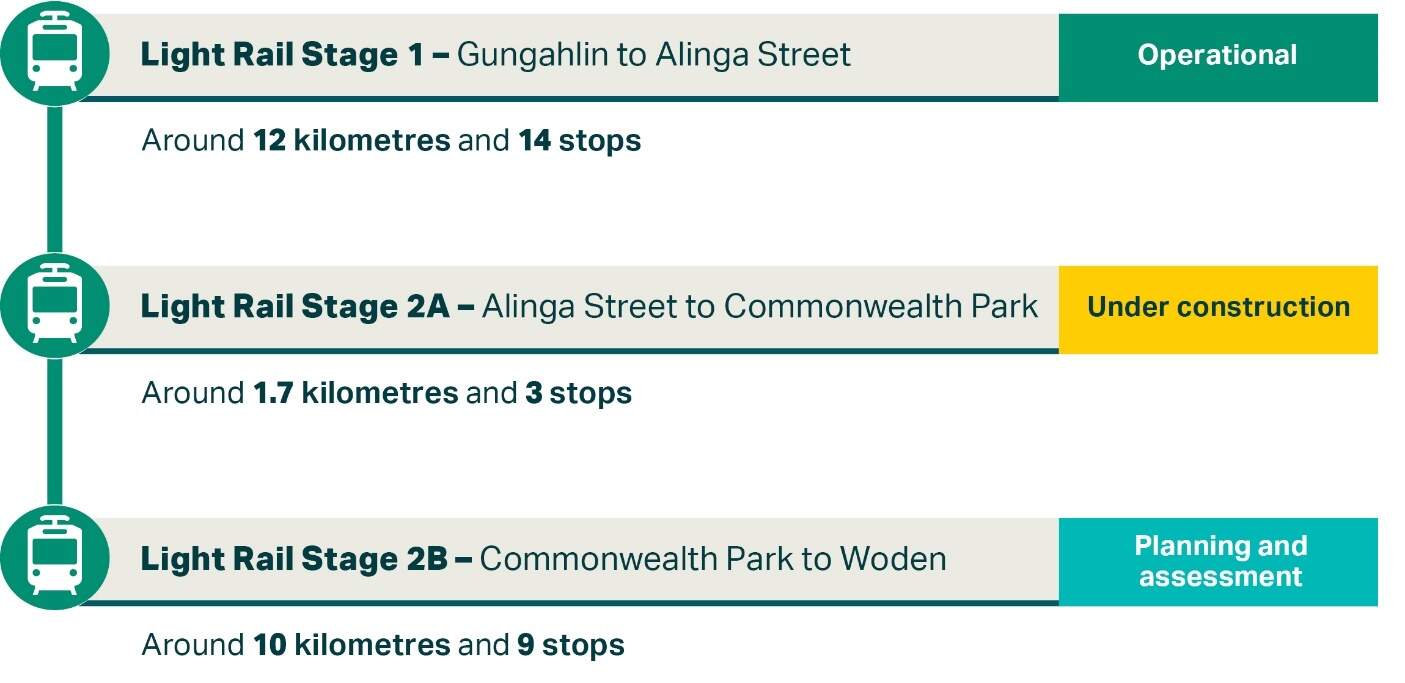
The Light Rail network has been carefully planned and implemented in stages, with the first 12 kilometres and 14 stops already in operation (refer to Figure E-1).
The benefits of Stage 1 of the Light Rail network are already apparent. The City, Braddon, Dickson and Gungahlin precincts are better connected by frequent and reliable transport. Development and urban renewal have been significant in areas such as Northbourne Avenue, New Acton, Verity and Odgers Lanes, Braddon, Dickson Village and Kambri at the Australian National University. The frequency, reliability and convenience of light rail has increased the overall use of public transport at night and on weekends, taken more cars off our roads, reduced congestion and contributed to our economy.
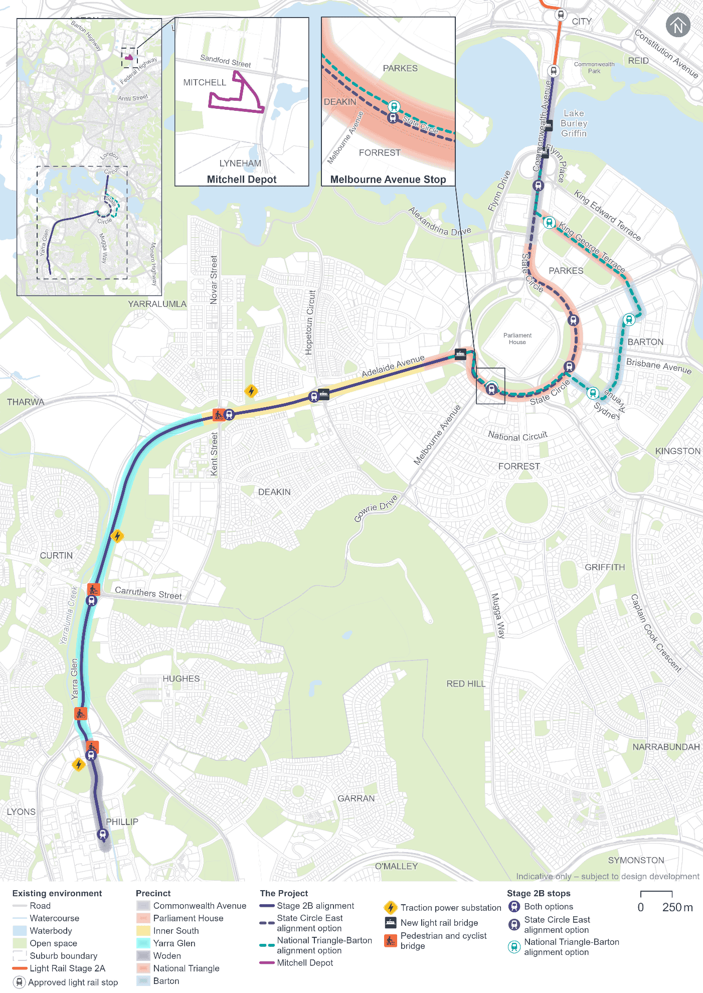
The Project would deliver light rail across Lake Burley Griffin, through the National Triangle, along Adelaide Avenue, and Yarra Glen, before terminating at Woden Town Centre. Key features of the Project are shown in Figure E-2.
Many key government offices and workplaces are within the National Triangle and a short walk, cycle or scoot from the Project. For Canberrans who work in the National Triangle, the Project would deliver certainty of journey time and the opportunity to incorporate active travel into their daily commute. The more than five million visitors who come to Canberra every year would have greater connectivity to nationally significant landmarks such as the National Gallery of Australia, the National Portrait Gallery, the National Library of Australia, the High Court of Australia and Parliament House (old and new).
Beyond the National Triangle, visitors would also be able to access key destinations along the light rail alignment such as the Lake Burley Griffin foreshore, Manuka Oval, the emerging west Deakin health precinct, embassies, the Royal Australian Mint, sporting venues and local shopping precincts. Improving connectivity with destinations is critical to attracting and retaining a high quality and talented workforce and building on Canberra's $3.4 billion per year tourism industry.
Put simply, extending the light rail south would make it easier for visitors and Canberrans alike to reach our national attractions, homes, services, institutions and employment hubs, while also enhancing the investment in, and diversification of, our economy.
The need for and benefits of the Project are described in more detail in Chapter 2 (Need for the Project).
As shown in Figure E-2, two alignment options for the Project are being considered through the National Triangle and around Parliament House to provide flexibility in planning. Both of these options have been assessed in this draft Environmental Impact Statement (EIS). These alignment options are:
- The ACT Government's preferred State Circle East alignment option: from Commonwealth Avenue along State Circle to Adelaide Avenue (shown in purple dotted lines in Figure E-2)
- An alternative National Triangle-Barton alignment option: from Commonwealth Avenue along King George Terrace, Macquarie Street, Bligh Street, National Circuit, and Sydney Avenue, before connecting with State Circle to Adelaide Avenue (shown in teal dotted lines in Figure E-2).
The EIS process will help to inform a decision on which alignment option is ultimately progressed. Regardless of which alignment option is delivered, the Project would involve the construction and operation of:
- Light rail track and stops, including new light rail bridges on Commonwealth Avenue over Lake Burley Griffin and on Adelaide Avenue
- Road network changes to accommodate the Project, including modifications to existing road carriageways and intersections, removal of the Melrose Drive bridge over Yarralumla Creek, new intersection arrangements, changes to line markings and traffic signal phasing
- Landscaping and public domain features along and around the Project alignment, as presented in the Public Domain Master Plan (refer to Appendix I)
- Ancillary infrastructure such as drainage and stormwater management infrastructure, power and water supply, lighting and telecommunications, traction power substations (TPSs), and utility adjustments
- Active travel (walking, cycling and micromobility) infrastructure to connect the community to the stops
- Upgrades to the existing Mitchell Depot site to accommodate additional light rail vehicles (LRVs) staff and storage.
The Project has been designed and would be delivered with a focus on avoiding or otherwise minimising potential environmental impacts. In this respect, consideration of heritage and landscape values has been embedded into the Project's design, including design of the associated public domain and landscaping approach. Full details of the Project are provided in Chapter 5 (Project description).
The construction duration for the Project will depend on design development, investigations (including geotechnical and utilities), and detailed construction planning, including the construction contractor's final proposed construction methodology. While early and enabling works would be required prior to the main construction works, a final decision on the packaging of the construction works would be made as part of ongoing Project development. Notwithstanding this, consistent with the scope of the Project as described above, construction is expected to cover:
- Early and enabling works
- Main construction works, including works relating to:
- Light rail infrastructure
- Earthworks
- Road works
- Bridges
- The covered section on Commonwealth Avenue (for the State Circle East alignment option)
- Stops
- Integration with existing active travel links
- Other infrastructure and utility works
- Finishing, testing, and commissioning.
These activities are described in more detail in Chapter 6 (Construction).
Construction planning has been, and would continue to be, developed with the aim of minimising disturbance to sensitive receivers, and balancing the intensity of construction activities with the desirability of completing construction in a timely and efficient manner. Key construction impacts, including traffic, noise and dust management, would be subject to a detailed Construction Environmental Management Plan(s) (CEMP).
Stakeholder and community engagement
The ACT Government has undertaken extensive community and stakeholder consultation in respect of Canberra's Light Rail network. By consulting with the community and taking into account their views (including in relation to strategic urban renewal), the first stage of light rail between the City and Gungahlin has shown that Canberrans embrace an integrated, reliable, and well-planned public transport network.
Detailed engagement on the Project EIS began in 2023, building on the engagement carried out for the broader Light Rail Stage 2 since 2017. This detailed engagement was based on a concept design and preliminary environmental investigations. This engagement increased awareness of the Project and identified issues of interest and concern to stakeholders and the broader community. Chapter 4 (Stakeholder and community consultation) details the stakeholder and community engagement undertaken and the relevant outcomes. Amongst other things, the engagement included:
- Stakeholder meetings
- Consultation with the Community Reference Group
- Community information sessions and pop-up events
- Aboriginal stakeholder consultation
- A community survey
- Business doorknocks
- Phone calls
- Distribution of printed and digital collateral.
The 'What We Heard' report also provides a summary of the community engagement that occurred between May and June 2024, and is available on the 'YourSay Conversations' (https://yoursayconversations.act.gov.au/) and 'Light Rail to Woden' (https://www.act.gov.au/lightrailtowoden) webpages.
Stakeholder and community engagement will continue through the public notification (exhibition) period for this EIS, and as the Project continues to be developed.
The outcomes of the stakeholder and community engagement activities are detailed in Chapter 4 (Stakeholder and community consultation).
Environmental and planning approvals and assessment approach
The Project requires four main environmental and planning approvals to allow for its construction and operation:
- Approval under the Environment Protection and Biodiversity Conservation Act 1999 (Cth) (EPBC Act)
- Development approval under the Planning Act 2023 (ACT) (Planning Act)
- Works approval under the Australian Capital Territory (Planning and Land Management) Act 1988 (Cth) (PALM Act), and
- Approval under the Parliament Act 1974 (Cth) (Parliament Act) for those parts of the Project within the Parliamentary Zone.
Further information on the environmental and planning approvals required for the Project is provided in Chapter 8 (Legislation and policy).
This document is a draft EIS, which will be subject to a public notification period (exhibition) and referred to relevant Commonwealth and Territory government entities. A revised, final EIS will be prepared, taking into account issues that may be raised in public submissions and representations in response to this draft EIS.
This EIS has adopted a precinct-based approach to the environmental assessment of the construction and operational impacts of the Project. The environmental assessment for each precinct allows focused consideration of key issues relevant to the precinct. Potential impacts with broader environmental implications, or that would be generally applicable to the whole Project, have been assessed on a Project-wide basis.
Noting the significant landscape values, tree assessments formed a large part of the investigations, with almost 3,000 individual tree assessments undertaken to inform both the biodiversity assessment (focussing more on native species with habitat value) and the landscape character and visual impact assessment (which typically focusses more on introduced species that underpin the formal landscapes around Parliament House).
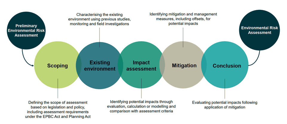
The general approach to the environmental impact assessment of the Project is shown in Figure E-3 has included:
- Scoping and describing the Project characteristics - what it would look like, and how it would be constructed and operated
- Undertaking a preliminary environmental risk assessment based on early design to identify likely key issues for detailed assessment
- Describing the existing environmental conditions within and around the Project boundary, against which the potential impacts of the Project can be assessed
- Identifying and assessing potential impacts, with reference to existing environmental conditions
- Assessing the significance of the potential construction and operational impacts
- Identifying measures to avoid, mitigate and manage, and where needed offset these impacts
- Assessing residual environment risks.
The EIS presents a series of potential impacts associated with construction and operation of the Project, which have been assessed as 'unmitigated' and as worst-case scenarios. Working with technical specialists, the ACT Government has developed and committed to implementing an extensive set of environmental management and mitigation measures (refer to Chapter 21 (Environmental management and mitigation measures)). The implementation of these measures would in many cases avoid potential worst-case impacts from the Project and otherwise minimise impacts, resulting in improved outcomes for the community and environment.
The approach and methodologies applied to the preparation of this EIS are detailed in Chapter 9 (Approach to the environmental assessment) and Chapter 10 (Assessment methodologies).
Key findings
Consistent with current development patterns, going forward, it is expected that 70 per cent of Canberra's growth will be within the existing urban footprint. As the population grows the ambition of the ACT Government is to protect and enhance the city's liveability by taking an integrated and holistic planning approach to maintain Canberra as a compact, accessible, sustainable and vibrant city.
The Project would be a core component in unlocking this ambition for several reasons.
It would provide additional transport capacity to a key area of the existing urban footprint. Areas such as Acton Waterfront, the future North Curtin Residential Area, and the Woden Town Centre are crucial for the future provision of more sustainable housing. The urban renewal planned for these areas, facilitated by the Project, would offer thoughtfully planned, flexible, and diverse housing choices. Light rail would ensure these homes are better connected to employment, entertainment, sports, shopping, and essential services.
Light rail is a hassle-free transport mode that operates regularly and reliably, day and night, including weekends. Evidence from Light Rail Stage 1 shows that Canberrans are increasingly using public transport outside traditional peak times, connecting with entertainment, recreation, retail, and hospitality venues more than ever before.
The Project would also unlock a gateway to the south and contribute to achieving the ACT's target of net zero carbon emissions. An integrated Light Rail network is more than just the journey between stops; it creates better connections to buses and improves 'last mile' offerings, including cycling and pedestrian routes.
Encouraging more people to leave their cars, whether for commuting, exploring, or connecting, contributes to a happier and healthier community and overall wellbeing. Wellbeing involves having the opportunity to lead lives with qualities such as good health, time to enjoy important things, and an environment that promotes personal growth.
Finally, accessibility features like level boarding, hearing loops, and spaces for wheelchairs, prams, and bikes would ensure that light rail is inclusive for all Canberrans and visitors to the city.
Notwithstanding the above, a thorough assessment of the Project is required and appropriate. This EIS assesses a range of environmental, construction, heritage, transport, economic and planning issues relevant to the Project. Key environmental findings, recommendations and outcomes from this EIS are summarised below and are presented in detail in Part B (Environmental impact assessment).
Biodiversity
Assessment approach and summary
While much of the original native biodiversity in central Canberra has been removed or fragmented due to urban development, some areas of remnant native vegetation still exist, particularly along parts of Commonwealth Avenue, State Circle, Adelaide Avenue, and Yarra Glen. Species protected under both Commonwealth and ACT legislation have been considered and biodiversity values within and around the Project area have been confirmed through vegetation and habitat surveys, and targeted surveys for individual threatened species.
Key potential impacts
Anticipated biodiversity losses would include some unavoidable clearing of native vegetation and habitat. Losses would include 5 to 6 hectares of native vegetation and between 116 and 126 mature native trees (noting 15 to 19 of those trees are hollow-bearing). Most impacts would be concentrated in the Parliament House and Yarra Glen precincts, which include potential habitat for several threatened species, including the Golden Sun Moth, Superb Parrot, Gang-gang Cockatoo and Diamond Firetail.
Surveys have not identified any listed threatened flora species or endangered ecological communities in areas likely to be disturbed by the Project.
Key recommendations, mitigation and management approaches
The Project has already made significant efforts to avoid and minimise impacts on native biodiversity through careful design and construction planning - including the avoidance of around 8 hectares of Golden Sun Moth habitat and 15 hectares of Gang-Gang Cockatoo and Superb Parrot foraging habitat. Ongoing design development would seek to minimise these impacts further. Mature native trees, especially hollow-bearing trees providing potential habitat for threatened species, would be retained and protected where possible. Disturbed sites, like existing car parks, have been targeted for construction compounds to reduce the need to impact more sensitive, undisturbed areas. Ongoing design development will consider enhancing habitat and connectivity through Project landscaping, using locally endemic native plants.
Measures to minimise the impacts on native biodiversity values would be detailed in a Biodiversity Management Plan as part of the CEMP(s) for the Project. Any residual impacts would be offset in accordance with the EPBC Act Offsets Policy. A final Biodiversity Offset Strategy will be developed once suitable offset sites have been confirmed.
Heritage (First Nations heritage and historic heritage)
Assessment approach and summary
The Project has required, and will continue to require, careful and considerate planning to conserve the important cultural and heritage values of all relevant areas, to maintain the well-known Canberra vistas, and to ensure Canberrans have access to a reliable and convenient transport option.
This EIS has been prepared with an appreciation that the Project will occur in a highly sensitive landscape recognised for its cultural, heritage and social values. Important elements of First Nations heritage include the Molonglo River, the geology of the State Circle Cutting as an ochre site, and Kurrajong (Capital) Hill.
More than 30 historic heritage sites listed on the Commonwealth Heritage List, National Heritage List and/or ACT Heritage Register have been identified in proximity to the Project area. Most are located around the northern extent of the Project, including Commonwealth Avenue, Parliament House, National Triangle and Barton precincts. These are associated with historic buildings, landscapes and natural heritage associated with establishing Canberra as the Nation's Capital.
Key potential impacts
The Project is not expected to directly impact any known First Nations heritage sites. The Project would, however, directly impact listed historic heritage places including:
- Parliament House Vista - some trees are expected to be lost, although every effort will be made to replace impacted trees and integrate light rail infrastructure
- Lake Burley Griffin and Adjacent Lands - the new light rail bridge may affect visual amenity, but it has been planned and designed to minimise visual and physical impacts
- Canberra Croquet Clubhouse and Lawns - it may be necessary to remove one tree, in which case it is planned that the tree would be replaced
- Hotel Kurrajong (National Triangle-Barton Option only) - the removal of some mature oak trees along the boundary of the site. Efforts will be made to retain the trees or, if this is not possible, to replace them.
In addition to direct impacts, the more than 30 listed heritage sites identified in proximity to the Project area may be indirectly affected by the Project during construction and operation. This may include potentially elevated indirect visual and landscape impacts on important heritage items through the National Triangle, Old Parliament House and Albert Hall. There would also be potential for indirect vibration impacts on these sites during construction, subject to final Project design and construction planning.
Key recommendations, mitigation and management approaches
Options to avoid and minimise heritage impacts have been implemented to date through the design development process and consideration of various design options/alternatives. The Project will continue to seek to minimise impacts where feasible during ongoing design development, with a focus on reinforcing heritage values and integrating cultural heritage into the Project design. Minimum separation distances to protect built heritage items from construction vibration will be implemented during specific construction activities. A Conservation Management Plan will also be developed as part of the CEMP for the Project.
Landscape character and visual amenity
Assessment approach and summary
The Project design has been developed recognising the highly sensitive cultural, heritage and natural landscapes that characterise and define Canberra as the nation's capital. Opportunities to integrate the Project into the landscape and minimise potential visual impacts have been identified and considered, and this approach will continue as the Project design progresses.
Potential impacts on landscape character have been assessed in the context of the unique setting of the Project, particularly the planned geometry of the city, significant vistas within and around the National Triangle and Lake Burley Griffin, natural landscape character values and the ongoing connection of Aboriginal people with the landscape.
Visual impacts during the operation of the Project have been assessed at 29 representative viewpoints. More substantial impacts have been identified in the northern precincts (Commonwealth Avenue, Parliament House, the National Triangle, and Barton) due to their higher cultural and historical significance, and sensitivity to visual disturbance.
Key potential impacts
Construction would be visually prominent and would affect much of the visual catchment around the Project area, resulting in pronounced but temporary impacts on landscape character and visual amenity.
Of the trees assessed as part of the EIS, the State Circle East alignment option may see around 700 removed while the alternative option could result in some additional trees removed. Recognising the importance of these living assets, the Project has committed to a minimum of a two for one replacement strategy. Consistent with the approach taken on Light Rail Stage 2A, the Project would utilise advanced tree stock for important replacements.
In the operation phase, the Project would introduce new elements into the landscape and key impacts are expected through the National Triangle, across Lake Burley Griffin (given the new bridge and the operation of LRVs), and within Canberra's planned geometry.
Key recommendations, mitigation and management approaches
Measures to minimise landscape character and visual impacts during construction will be detailed in a Visual Impact Management Plan as part of the CEMP(s) for the Project.
Where feasible, development of the Project alignment has sought to minimise changes to landscape character and visual amenity by following existing transport corridors, particularly along Commonwealth Avenue and Adelaide Avenue. Opportunities to visually integrate Project infrastructure into the surrounding landscape have been considered, and will continue to be an important focus in ongoing design development.
The Project design already includes several initiatives to reduce visual intrusion. These include wire-free operation from Commonwealth Park to Hopetoun Circuit, and the location of stops in places that would minimise landscape and visual heritage impacts. A particular focus on these approaches has been along, around and within the Parliament House Vista, the National Triangle and Lake Burley Griffin.
Further design development of the Project will be guided by the Public Domain Master Plan (refer to Appendix I), a Designing with Country Framework, a Landscaping Plan, and tree succession planning.
Traffic and transport
Assessment approach and summary
Canberra is not immune to congestion-related delays which plague many cities. An important part of an integrated response to tackling this congestion and its adverse impacts is the provision of non-road base transport alternatives, such as light rail. Each LRV can carry as many passengers as three buses, and can provide an effective and efficient means of shifting the city's transport needs off the existing congested road network. This effect has already been demonstrated with traffic along the Light Rail Stage 1 corridor reducing by around 20 per cent. This is equivalent to removing 4,800 carbon-producing road vehicle trips every hour.
Traffic modelling for 2031 and 2041 has been used to assess the performance of the road network both with and without the Project. The modelling has incorporated only 'committed and funded' projects (i.e.without reference to any other future transport investment or infrastructure) in accordance with relevant and applicable guidelines.
Consistent with expected population growth, the modelled traffic for these future years shows significant peak period traffic congestion across Canberra. However, as the modelling did not take into account some of the ACT Government's planned future changes to the transport network, the transport modelling presents a worst-case, conservative assessment.
Assessment of the outcomes of the traffic modelling, both with and without the Project in future years, has highlighted:
- Without further investment in roads and public transport (including light rail), significant traffic congestion and deteriorating vehicle and bus travel times will occur, especially during peak hours
- The Project would assist in alleviating congestion along its alignment and the surrounding road network by offering a transport choice not subject to road-based congestion impacts
- Additional measures and investment will be needed over time to fully resolve all transport issues arising from the increasing population.
Key potential impacts
As would be expected with any major infrastructure project, during the construction phase:
- There would be temporary disruptions, speed limit changes, and lane and road closures leading to traffic redistribution. Key affected areas would include Commonwealth Avenue, State Circle, and Adelaide Avenue, with increased traffic on alternative routes such as King Edward Terrace and Bowen Drive
- Vehicle travel times during peak hours could increase by more than five minutes on the most affected routes
- There would be some temporary reductions in available parking spaces to cater for construction activities and compounds.
These impacts would be temporary and limited to the construction period.
During the operations phase:
- The Project would provide additional transport capacity, accommodating around 2,400 people per hour in each direction
- The Project would improve active transport connectivity with new pedestrian and cyclist infrastructure
- Some permanent changes to the road network would be required, with some lane adjustments, intersection modifications, road closures and reconfigurations, and minor reductions in car parking spaces.
Key recommendations, mitigation and management approaches
Measures to minimise and manage traffic and transport impacts (including active travel) during construction will be detailed in a Transport Management Plan as part of the CEMP(s). The Plan will include a detailed Traffic Demand Management Strategy, implementation of a Traffic and Transport Liaison Group to endorse Temporary Traffic Management Plans and a complementary Community Engagement Strategy.
Noise and vibration
Assessment approach and summary
Given the Environment Protection Regulation 2005 (ACT) does not impose specific noise limits for construction of major transport projects, construction noise for the Project has been assessed with reference to the NSW Interim Construction Noise Guideline (NSW Department of Environment and Climate Change, 2009).1
1 https://www.environment.nsw.gov.au/resources/noise/09265cng.pdf
The noise assessment has considered scenarios based on anticipated worst-case construction activities, without the application of mitigation measures, and has adopted conservative assumptions. Actual noise levels experienced by receivers during construction of the Project would therefore be lower than the conservative construction noise predictions presented within the assessment.
Most construction and noise generating activities would be conducted during standard construction hours. However for some specific construction activities, works would need to be undertaken outside standard hours to minimise wider disruption or for worker safety, and these have been included in the conservative modelling.
During operation, noise and vibration from operation of light rail vehicles, fixed facilities and the Mitchell Depot have been assessed. Changes in road traffic noise due to alterations to the road network required for the Project have also been assessed.
Key potential impacts
New noise and vibration sources would be introduced during the construction phase. Key activities causing elevated noise would include mobilisation of construction compounds, utility works, earthworks, road works, light rail infrastructure construction, stop construction, and bridge construction. However, most construction would occur during standard construction hours, with some limited activities needing to be undertaken outside of these hours (for example key intersection works). A substantial portion of the Project would be located within already busy transport corridors, with surrounding receivers already experiencing elevated background noise levels. Additional temporary construction noise impacts from the Project would occur in this context, with some masking of construction noise impacts provided by existing elevated background noise levels.
Operational noise from the Project would be generally within acceptable limits. Vibration from LRVs would not exceed criteria for the protection of human comfort at the vast majority of receivers (assuming that such vibration would be perceptible to human senses, without the application of mitigation measures) or structural integrity, including for heritage structures.
Key recommendations, mitigation and management approaches
Measures to minimise and manage construction noise and vibration will be detailed in a Noise and Vibration Management Plan as part of the CEMP(s). This will include scheduling of noise and vibration intensive activities with appropriate respite periods, and minimising works during noise sensitive periods (any out of hours works would be assessed on a case-by-case basis prior to proceeding). Furthermore:
- An Operational Noise and Vibration Review (ONVR) will be prepared as part of ongoing design development
- An Operational Environment Management Plan (OEMP) will be prepared and implemented. The OEMP will specify the environmental requirements to be implemented during the operational phase of the Project.
Social and economic considerations
Assessment approach and summary
Assessment of the socioeconomic impacts of the Project has included an analysis of the demography, economic baseline and employment profiles of catchments along and around the Project alignment. Business community engagement has been carried out to identify potential concerns, impacts and opportunities for different businesses and sectors operating near the Project. The assessment approach has included one-on-one discussions and a business survey.
Key potential impacts
The Project would provide a range of positive social impacts including provision of an efficient and reliable transport option, supporting health and wellbeing and benefits to the business community through increased connectivity. Significant economic benefits would include the provision of customer access, broadening the customer base, new opportunities with additional residential and commercial developments over time and the potential for employment and services in construction and operations phases.
The Project would contribute to the ongoing liveability and desirability of Canberra, supporting both social and economic wellbeing.
Some stakeholders have expressed concerns about the potential disruptions during the construction phase to local residents and businesses. Concerns have also been raised in relation to access to events, and a potential resource strain due to an increased demand for skilled labour. During the operation phase, stakeholders have identified concerns in relation to community safety, parking availability, and impacts on social amenity due to operational noise.
Key recommendations, mitigation and management approaches
Environmental management and mitigation measures for traffic and transport impacts, noise and vibration, and property access are described in the relevant sections of this Executive Summary.
Other measures to minimise and manage potential adverse impacts on the community will be detailed in a Community Engagement and Social Management Plan developed as part of the CEMP(s), including:
- A Community Engagement Strategy (including a range of stakeholders and communities along the Project alignment, including users of Lake Burley Griffin)
- A Business and Labor Strategy, covering support for local businesses and workforce management.
Hydrology, flooding, water quality and groundwater
Assessment approach and summary
The Project would span four sub-catchments that drain into Lake Burley Griffin and eventually into the Murrumbidgee River. These sub-catchments have existing degraded water quality due to urban runoff pollutants.
Flood modelling has been conducted to assess potential changes in flooding characteristics, including major flood scenarios and the effects of climate change.
Key potential impacts
The Project may affect water resources through surface water runoff and changes in drainage and hydrology during construction and operation.
There would also be potential for the Project to intercept perched groundwater during larger scale excavation activities, such as the transition from Commonwealth Avenue to State Circle. However, the Project is not expected to substantially impact groundwater hydrology or quality.
Construction of the new light rail bridge across Lake Burley Griffin has the potential to temporarily affect water quality in Lake Burley Griffin through sediment disturbance and accidental spills.
The Project has been designed to avoid and minimise adverse changes to hydrology, including local and regional level flooding characteristics. Flood modelling has been carried out as part of design development, and embedded in the Project's design response to identified flooding and drainage issues. The result of this approach has been no material changes to flood levels, and some areas, improvements in flood levels due to improved drainage.
Key recommendations, mitigation and management approaches
It is expected that wastewater will be collected, managed, and disposed of either to sewer or an offsite treatment facility if reuse is not possible. Intercepted groundwater will be collected, managed, and transported offsite for treatment and reuse or disposal. Water sensitive urban design will also be integrated into the Project design to effectively manage and minimise the release of pollutants to the surrounding environment.
Coffer dams and other measures will be installed to minimise sediment disturbance and turbidity in Lake Burley Griffin during the construction of the new light rail bridge. Erosion and sedimentation control measures will be applied in construction, consistent with best practice guidelines and relevant approvals. Detailed water quality and hydrology measures (including a Surface Water and Groundwater Plan and a Sediment and Erosion Control Plan) will be included in the CEMP(s) for the Project.
Ongoing design development will seek to minimise material adverse changes in flood characteristics along and around the Project. Within the Yarralumla Creek catchment, the Project has committed to establish a design, through interagency coordination and further studies, that responds to future climate change projections.
Other environmental Issues
Soils and contamination
The assessment has included review of historical and current land use, contamination data, and identified areas of environmental concern based on potential contamination. No existing sites with extensive, migrating, or intractable contamination issues have been found within or near the Project area. Further investigations will be conducted in areas with potential contamination risk to inform Project design and construction planning. Measures to minimise and manage future contamination risks will be detailed in a Soils and Contamination Management Plan as part of the CEMP(s). The ACT Environment Protection Authority will be engaged for managing contamination, including offsite transport, treatment, and disposal if a contamination issue occurs.
Land use and property
The Project has been assessed under the NCP and the Territory Plan 2023, generally aligning with their respective aims and objectives, though the National Triangle-Barton alignment option would require an NCP amendment were it to be progressed. Most infrastructure associated with the Project would be on government land, with minimal impact on privately leased land. Specific mitigation measures have been identified to enable the management of property access during the construction phase. Once complete, the Project may increase land desirability around stops, altering development types over time. Ongoing planning and design effort will minimise private land encroachment, will include engagement with leaseholders on land use and access, and will maintain ongoing consultation with planning agencies for future strategic planning in Canberra.
Air quality
The assessment approach for general construction and operations emissions has been conducted on a Project-wide basis, while potential dust generation has been evaluated considering the magnitude of dust and the sensitivity of potentially affected receivers. Key potential impacts would include emissions from construction plant and equipment (combustion fuel) and dust from excavation and construction activities, which may affect local residents and businesses. Operational emissions would be minimal, and would primarily relate to increased maintenance activities at the Mitchell Depot site. Key recommendations and mitigation measures, including air quality issues, will be detailed in the CEMP(s) and OEMP with a specific Dust Management Plan included.
Climate change and greenhouse gas emissions
The assessment of climate change and greenhouse gas (GHG) emissions for the Project has considered future climate impacts, such as extreme rainfall, flooding, and heat events, which could affect construction schedules, worker safety, and costs. During operation, the Project could face extreme weather events and temperature changes impacting design and reliability. Direct GHG emissions would come from construction activities, while indirect emissions would result from the broader economy. Electricity-related emissions would be zero due to the ACT's renewable energy sources. The Project has been designed to be resilient to climate changes, with ongoing design development focusing on minimising climate-related risks and reducing GHG emissions from major contributors like fuel consumption and selection of construction materials. A Sustainability Management Plan and a Carbon Management Plan will be part of the CEMP(s) and OEMP to ensure effective mitigation and adaptation measures.
Materials, waste and resources
To support effective waste management, the Project has identified potential waste types early, referencing the circular economy and waste hierarchy. Significant quantities of materials required for the Project would include concrete, aggregates, asphalt, metals, and smaller quantities of timber, PVC, HDPE, fuel, oils, and prefabricated items, with sufficient supply available. The Project would also require electricity and water, with utility providers confirming capacity. The largest construction waste stream would be excess spoil. Following the ACT Waste Management Strategy 2011-2025, the Project will prioritise waste avoidance, reduction, reuse, recycling, and disposal, exploring opportunities for offsite reuse of excess spoil. Waste management measures will be detailed in a Spoil and Waste Management Plan within the CEMP(s).
Hazards and risk
Constructing and operating a major transport project involves some potential hazards and risks to public safety, worker health, and the environment. Assessment of the Project has considered these risks and has included management measures to mitigate them. Key construction risks would include public and worker safety, hazardous materials, utility interactions, and bushfire risk areas, while operational risks focus on public safety and road traffic. A Work Health Safety (WHS) Management Plan and a Rail Accreditation, Safety and Systems Assurance Plan will ensure compliance with relevant laws. The Project would eliminate hazards where possible and would apply controls to minimise risks. Each site will be reviewed for potential hazards, with the CEMP(s) detailing specific risk mitigation measures. Infrastructure design will incorporate public safety features like Crime Prevention through Environmental Design, Gender Sensitive Urban Design, and universal accessibility features.
Conclusion and next steps
The Light Rail Stage 2B Project is a transformative opportunity for the ACT to capitalise on its urban structure within a central public transport corridor that would promote development in areas located close to defined activity centres and major employment hubs along key transit routes. Complemented by a mix of other transport improvement initiatives, the Project would support the ACT's plans for sustainable urban growth by providing a frequent and reliable public transport option in a planned growth corridor while also helping to reduce projected road network congestion and its associated adverse impacts to wellbeing.
By continuing to plan and develop the Project in a way that is sensitive to the ACT's heritage, its natural environment, and the needs of local communities and visitors, Canberrans would be the beneficiaries of a modern, sustainable transport option that would make an essential contribution to the city's liveability, well into the future.
This draft EIS is an essential step to make sure that all relevant environmental considerations and concerns are identified and considered before the Project progresses. It highlights the expected short term and permanent Project impacts and the ACT Government's intended mitigation and management approaches.
Key impacts of construction activities would include temporary traffic disruption, construction noise and impacts to visual amenity. As was the case during the delivery of Light Rail Stage 1, these impacts would be mitigated in accordance with appropriate industry standards and ACT guidelines, and managed via the CEMP(s). Given the highly sensitive nature of some areas along and around the Project, additional issue and location specific mitigation measures have also been developed, for example specific controls relating to construction in the vicinity of important heritage buildings, vistas and landscapes.
Key permanent impacts during operations include:
- Removal of native vegetation and habitat, and potential impacts on native species. Mature native trees, especially hollow-bearing trees providing habitat for threatened species, are avoided and protected where possible. Ongoing design development will focus on enhancing habitat and connectivity through landscaping with locally endemic native plants. Regardless, there are expected to be some residual impacts that would be offset in accordance with the EPBC Act Offsets Policy
- Historic heritage, landscape and visual amenity would be impacted by the introduction of the light rail infrastructure. The Project has been designed to minimise changes to heritage, landscape character and visual amenity, with the alignment being predominantly within existing transport corridors. A distinctly sensitive landscape design has been developed for Commonwealth Avenue including the new light rail bridge over Lake Burley Griffin and the use of wire-free technology to reduce visual intrusion. The Project will continue to seek to minimise impacts during design development, with a focus on reinforcing heritage values, landscaping succession and renewal, and integrating cultural heritage into the Project design.
This draft EIS will be subject to a public notification (exhibition) period under the Environment Protection and Biodiversity Conservation Act 1999 (Cth) and the Planning Act 2023 (ACT). Interested and affected stakeholders are encouraged to make a submission and/or representation the Project and the draft EIS at this time.
Following public exhibition of the draft EIS, the submissions received from community and stakeholders along with other input that may be received from regulatory agencies and public authorities will be reviewed and considered. A revised, final EIS will be prepared that responds to issues raised during the consultation process. The final EIS will describe only one alignment option and will identify potential environmental impacts and benefits of that option. The final EIS may also update aspects of the Project and its environmental impact assessment to reflect ongoing design development, additional investigations and changes aimed at further minimising environmental impacts.