Sydney Metro West - Interactive project portal
In 2020, work started at The Bays on this city shaping project to allow tunnel boring machines to be in the ground before the end of 2022. In March 2021, the project received its first major planning approval for the Project Concept between Westmead and the Sydney CBD and station excavation and tunnelling between Westmead and The Bays.
A subsequent planning application for major civil construction between The Bays and Sydney CBD, including station excavation and tunnelling, was submitted to the Department of Planning and Environment (DPE) in 2021 and is currently under assessment.
Sydney Metro is now seeking approval for rail infrastructure, stations, precincts and operations between Westmead and the Sydney CBD.

Placeholder
Awaiting content
Submission closed
Submissions for the Bays Road Relocation Works Review of Environmental Factors (REF) have now closed. The feedback we received from the community will be reviewed by Sydney Metro and a detailed report will be published on our website.

Proposed construction site for Pyrmont Station
Proposed construction site for Pyrmont Station

Proposed construction site for Hunter Street Station
Proposed construction site for Hunter Street Station
Sydney Metro West proposed corridor
The Department of Planning, Industry and Environment amended the State Environmental Planning Policy (Infrastructure) to protect a tunnel corridor of approximately 30 metres from the Sydney Metro West tunnel alignment to provide for the long term protection of the tunnels.
Sydney Metro will conduct a formal process to acquire underground land for the tunnel alignment once the tunnel alignment design is confirmed. The project team will contact all affected property owners directly.
In the majority of cases, underground land acquisition will not affect the future use of the property. Sydney Metro will only acquire the land it needs to safely construct the tunnels and provide for their long-term protection.

High voltage power routes
TBMs and roadheaders used to construct tunnels and would require a dedicated power source. This means new cables would need to be installed between the metro site and a nearby substation. Power would be supplied from Endeavour Energy’s Rosehill zone transmission substation
Residents and businesses located along the proposed cable routes would be notified of the timing and duration of these works.
-launch-site-min.jpg)
Tunnelling
The Sydney Metro West tunnels will be 38 metres deep on average – that’s about 13 storeys below ground.
Tunnel boring machines (TBMs) will be launched from both Clyde and The Bays. TBMs will be retrieved from Sydney Olympic Park and Westmead.

Noise mitigation
Sydney Metro hoarding would be erected around the perimeter of the construction site to mitigate potential noise impacts.
Potential construction noise and vibration impacts would be managed in accordance with the Sydney Metro Construction Noise and Vibration Strategy, which aims to manage noise and vibration levels through feasible and reasonable measures. The Strategy provides a process for the development of site or activity specific Construction Noise and Vibration Impact Statements, standard mitigation measures and additional mitigation measures to be implemented based on noise and vibration levels.
The Sydney Metro West team would consider alternative construction methods to help mitigate noise where possible and would work with the community to provide scheduled respite periods during which high noise or vibration activities are not undertaken.

Heritage
Management and mitigation measures would be used where impacts to heritage items have been identified.
This may include conservation and re-use of heritage fabric, and archiving and recording the item for future generations.
Any potential archaeological investigations would be undertaken as required in accordance with Heritage Council guidelines. Any potential Aboriginal archaeological remains found would be interpreted by an Aboriginal heritage specialist in consultation with registered Aboriginal parties.
The heritage listed Kia Ora building and a heritage listed shop would be located within the construction site and would be protected during construction.
This site may contain potential Aboriginal and non-Aboriginal archaeological deposits. Investigation work would be carried out prior to construction work occurring and any remains found would be interpreted by the relevant specialists.

Station excavation
Westmead metro station will be a cut-and-cover station of about 30 metres or 10 storeys deep. A cut-and-cover station involves excavating a rectangular hole in the ground, which will then house the underground station.
Tunnel boring machine (TBM) launch site
The Sydney Metro West tunnels will be 38 metres deep on average – that’s about 13 storeys below ground.
Tunnel boring machines (TBMs) will be launched from both Clyde and The Bays. TBMs will be retrieved from Sydney Olympic Park and Westmead.

Westmead construction footprint

High-voltage power routes
Tunnel boring machines and roadheaders used to construct tunnels, passages and caverns between Westmead and The Bays will require dedicated power sources. This means new cables will need to be installed between some metro sites and nearby substations or existing power sources.
Power supply routes will generally be located within existing road reserves and under-boring may be used to minimise impacts on major roads or infrastructure.
The cables will be laid underground and construction will generally include:
- investigating sites to locate existing services and assess ground conditions
- digging trenches and installing conduits (plastic pipes) to hold the new cables
- filling trenches and resurfacing the areas in consultation with the local council
- installing one small electricity kiosk within each metro site.

Traffic network changes
Sydney Metro will keep the road network moving during construction by adopting site-specific traffic management plans to minimise temporary impacts. Works at Westmead metro station will involve a number of permanent and temporary traffic changes.
Permanent changes:
- Alexandra Avenue - closure and realignment between Hassall Street and Hawkesbury Road (at the start of construction)
- Hawkesbury Road, Grand Avenue and the realigned Alexandra Avenue - new signalised intersection (at the completion of tunnelling and excavation works)
- Hawkesbury Road / Alexandra Avenue - modification of traffic signals (at the completion of tunnelling and excavation works).
- Alexandra Avenue / Hassall Street - modification of traffic signals (at the completion of tunnelling and excavation works)
Traffic network changes
Sydney Metro will keep the road network moving during construction by adopting site-specific traffic management plans to minimise temporary impacts. Works at Westmead metro station will involve a number of permanent and temporary traffic changes.
Temporary changes:
- Bailey Street - detour between Hawkesbury Road and Hassall Street around the closed section of Alexandra Avenue (see permanent changes to Alexandra Avenue)
- Hawkesbury Road / Alexandra Avenue - modification of traffic signals
- Alexandra Avenue / Hassall Street - modification of traffic signals
- Hawkesbury Road / Bailey Street - new traffic signals
Transport changes
Construction work will require the relocation of bus stops and include changes to bus routes at Westmead. Changes to bus stops and bus routes will be carried out in consultation with stakeholders, and the project team will ensure commuters are provided with information about changes to bus stops in advance of any changes occurring. The following transport changes will occur at Westmead:
- Bus services – relocation of two bus stops on Alexandra Avenue between Hawkesbury Road and Hassall Street.
The temporary and final locations of bus stops will be determined in consultation with bus operators and road authorities.
Parking changes
During construction there will be changes to parking on local streets.
About 35 parking spaces adjacent to the construction site will need to be temporarily removed along Hassall Street and Bailey Street to allow trucks to enter and exit the construction site safely.

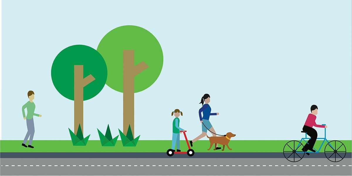
Pedestrians and cyclists
Safety is our number one priority at Sydney Metro and appropriate controls will be established to ensure the safety of local communities. Where vehicles will be required to cross footpaths to access construction sites, manual supervision, physical barriers or temporary traffic lights will be used as required.

Haulage routes
Designated haulage routes will be used by trucks to transport materials to and from the construction site. Site access will be Bailey Street via Hawkesbury Road: left-in, and Hawkesbury Road: left-out.

Noise mitigation
An acoustic shed and/or other acoustic measures will be in place at Westmead to mitigate potential temporary noise impacts.
Potential construction noise and vibration impacts will be managed in accordance with the Sydney Metro Construction Noise and Vibration Standard which aims to manage noise and vibration levels through feasible and reasonable measures. The Standard provides a process for the development of site or activity specific Construction Noise and Vibration Impact Statements, standard mitigation measures and additional mitigation measures to be implemented based on noise and vibration levels.
The Sydney Metro West team will consider alternative construction methods to help mitigate noise where possible and will work with the community to provide scheduled respite periods during which high noise or vibration activities are not undertaken.

Nearby projects
Sydney Metro is committed to working closely with other nearby projects, local councils, NSW Government agencies and stakeholders to manage and coordinate construction activities and traffic, to help minimise impacts on the community. Other projects near to Westmead metro station include:
Rail infrastructure
Just like the Metro North West Line, Sydney Metro West will use advanced world-class signalling technology to support safe operations and control the way trains accelerate and brake at stations.
The signalling and train control system, operating from the Clyde stabling and maintenance facility, will automate the metro trains, including train spacing and speed monitoring.
Communications equipment will be within the designated services area at each station and also within the tunnels and at the Clyde stabling and maintenance facility.
Access shafts will be constructed for tunnel fit-out and rail systems work at Parramatta metro station, Burwood North Station, The Bays Station and Clyde stabling and maintenance facility.
Station excavation
Parramatta metro station will be a cut-and-cover station of about 28 meters or 10 storeys deep. A cut-and-cover station involves excavating a rectangular hole in the ground, which will then house the underground station.
Heritage
Tunnelling works are not anticipated to impact on heritage items in Parramatta Park.

Parramatta construction footprint
High-voltage power routes

Tunnel boring machines and roadheaders used to construct tunnels, passages and caverns between Westmead and The Bays will require dedicated power sources. This means new cables will need to be installed between some metro sites and nearby substations or existing power sources.
Power supply routes will generally be located within existing road reserves and under-boring may be used to minimise impacts on major roads or infrastructure.
The cables will be laid underground and construction will generally include:
- investigating sites to locate existing services and assess ground conditions
- digging trenches and installing conduits (plastic pipes) to hold the new cables
- filling trenches and resurfacing the areas in consultation with the local council
- installing one small electricity kiosk within each metro site.
Traffic network changes
Sydney Metro will keep the road network moving during construction by adopting site-specific traffic management plans to minimise temporary impacts. Works at Parramatta metro station will involve a number of permanent and temporary traffic changes.
Temporary changes:
- Horwood Place – closure and temporary detour via Smith and Church streets
- Church Street – construction of a temporary rear access lane to maintain access for properties fronting Church Street
Parking changes
During construction there will be changes to parking on local streets.
About 35 parking spaces will be removed from Horwood Place to facilitate construction of the new station and allow trucks to enter and exit the construction site safely.
Pedestrians and cyclists
Safety is our number one priority at Sydney Metro and appropriate controls would be established to ensure the safety of local communities. Where vehicles would be required to cross footpaths to access construction sites, manual supervision, physical barriers or temporary traffic lights will be used as required.
The following change to pedestrian and cyclists routes will occur at Parramatta:
- Horwood Place - temporary closure of pedestrian and cyclist routes for the duration of the construction work – alternative detour routes would be established via Church and Smith Streets
- Batman Walk - permanent closure of the walkway between Macquarie Street and Macquarie Lane.
Permanent pedestrian and cyclist access arrangements will be subject to future station design and consultation with the local council.
Haulage routes
Designated haulage routes will be used by trucks to transport materials to and from construction site. Site access will be Site access will be George Street: right-in and left-out
Nearby projects
Sydney Metro is committed to working closely with other nearby projects, local councils, NSW Government agencies and stakeholders to manage and coordinate construction activities and traffic, to help minimise impacts on the community. Other projects near to Parramatta metro station include:
Parramatta Light Rail – Stage 1
Planned Parramatta Light Rail – Stage 2

Placemaking
Parramatta is identified in the Central City District Plan (Greater Sydney Commission, 2018b), as one of Australia’s most important CBDs and business hubs.
The Parramatta metro station will support strengthening of the Parramatta CBD through:
- high quality station and precinct design
- a strong city centre connection between Parramatta Square and the Parramatta River and integrating with the future Civic Link
- an activated precinct around the station that encourages pedestrian movement
- pedestrian and cyclist link and easy interchanges with other transport services
Heritage
Management and mitigation measures will be used where impacts to heritage items have been identified.
This may include conservation and re-use of heritage fabric, and archiving and recording the item for future generations.
Any potential archaeological investigations will be undertaken as required in accordance with Heritage Council guidelines. Any potential Aboriginal archaeological remains found will be interpreted by an Aboriginal heritage specialist in consultation with registered Aboriginal parties.
The heritage listed Kia Ora building and a heritage listed shop will be located within the construction site and would be protected during construction.
This site may contain potential Aboriginal and non-Aboriginal archaeological deposits. Investigation work will be carried out prior to construction work occurring and any remains found will be interpreted by the relevant specialists.
Noise mitigation
Sydney Metro hoarding will be erected around the perimeter of the construction site to mitigate potential noise impacts.
Potential construction noise and vibration impacts will be managed in accordance with the Sydney Metro Construction Noise and Vibration Standard which aims to manage noise and vibration levels through feasible and reasonable measures. The Standard provides a process for the development of site or activity specific Construction Noise and Vibration Impact Statements, standard mitigation measures and additional mitigation measures to be implemented based on noise and vibration levels.
The Sydney Metro West team will consider alternative construction methods to help mitigate noise where possible and would work with the community to provide scheduled respite periods during which high noise or vibration activities are not undertaken.

Supporting services and infrastructure
The project requires land to stable metro trains and to house the maintenance and operational facilities associated with running a world-class metro railway.
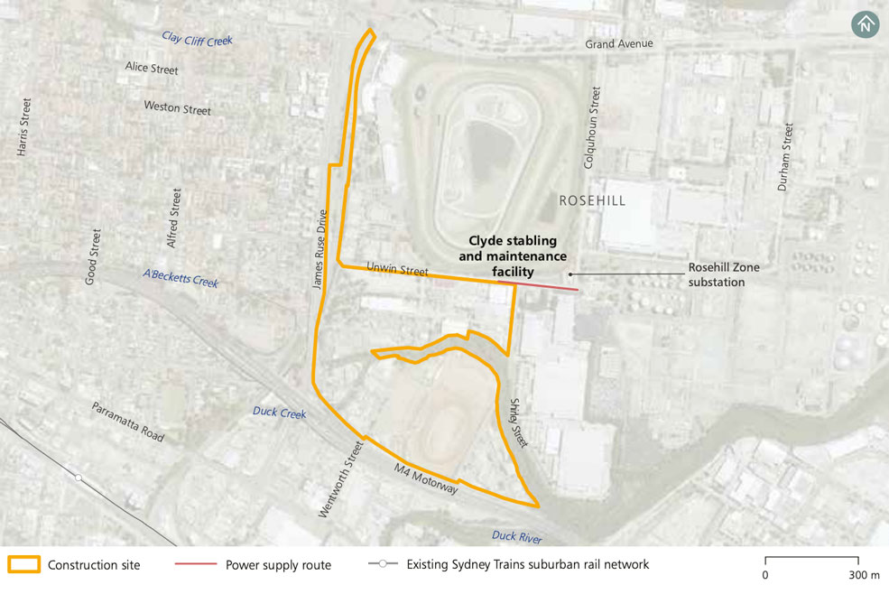
A stabling and maintenance facility will be located in the Clyde and Rosehill industrial estate bounded by James Ruse Drive, the M4 Western Motorway, Unwin Street and Shirley Street.
Work to establish this facility will include:
- site establishment and demolition
- land preparation– to prepare the site for the stabling and maintenance facility
- building a road underpass
- excavating a shaft – for a services facility
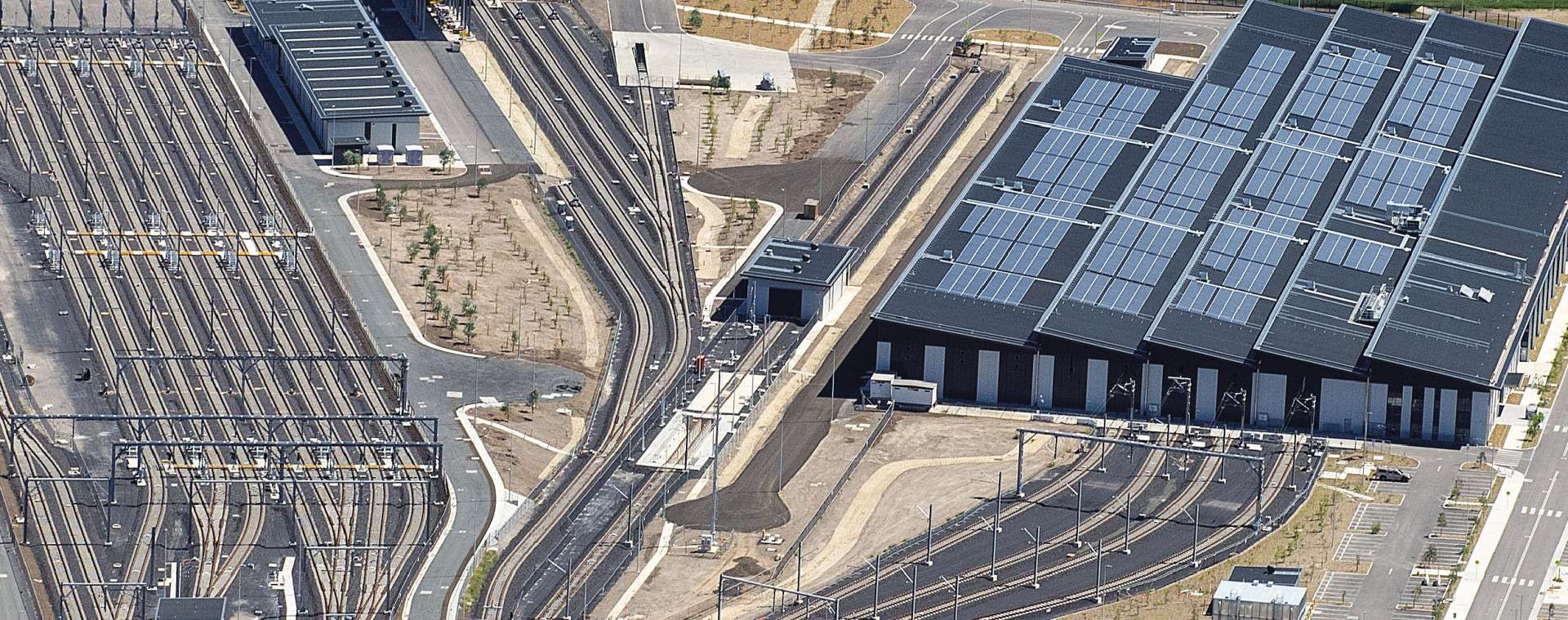
Clyde stabling and maintenance facility modification
Following a design refinement process, Sydney Metro is proposing to modify the approval for the Clyde stabling and maintenance facility. The proposal involves relocating the tunnel dive structure to the north-east avoiding the need to relocate a major Sydney Water sewer main that services the local area.
Clyde stabling and maintenance facility modification newsletter
High-voltage power routes
Tunnel boring machines and roadheaders used to construct tunnels, passages and caverns between Westmead and The Bays will require dedicated power sources. This means new cables will need to be installed between some metro sites and nearby substations or existing power sources.
Power supply routes will generally be located within existing road reserves and under-boring may be used to minimise impacts on major roads or infrastructure.
The cables will be laid underground and construction would generally include:
- investigating sites to locate existing services and assess ground conditions
- digging trenches and installing conduits (plastic pipes) to hold the new cables
- filling trenches and resurfacing the areas in consultation with the local council
- installing one small electricity kiosk within each metro site.

Clyde stabling and maintenance facility construction footprint
Traffic network changes
Sydney Metro will keep the road network moving during construction by adopting site-specific traffic management plans to minimise temporary impacts. Access will be maintained to all local businesses. Works at Clyde will include the following change:
Permanent change
- Unwin Street - permanent realignment around the construction site, including the construction of an underpass under the future metro rail tracks to ensure the heavy vehicle route is maintained
Parking changes
During construction there will be changes to parking on local streets.
Temporary removal of on-street parking spaces will allow trucks to enter and exit the site safely, including Unwin and Wentworth streets – up to 10 on-street parking spaces.
Pedestrians and cyclists
Safety is our number one priority at Sydney Metro and appropriate controls will be established to ensure the safety of local communities. Where vehicles will be required to cross footpaths to access construction sites, manual supervision, physical barriers or temporary traffic lights will be used as required.
Haulage routes
Designated haulage routes will be used by trucks to transport materials to and from construction site. Site access will be via Wentworth Street to Parramatta Road.
Nearby projects
Sydney Metro is committed to working closely with other nearby projects, local councils, NSW Government agencies and stakeholders to manage and coordinate construction activities and traffic, to help minimise impacts on the community. Other projects near the Clyde stabling and maintenance facility include:
Heritage
Management and mitigation measures will be used where impacts to heritage items have been identified.
This may include conservation and re-use of heritage fabric, and archiving and recording the item for future generations.
The proposal will require the removal of approximately 0.7 hectares of heritage wetlands.
A heritage listed former Roads & Transport Authority (RTA) depot will be located within the construction site and will be protected during construction.
This site may contain potential Aboriginal archaeological deposits. Investigation work will be carried out prior to construction work and any remains found will be interpreted by the relevant specialists. Any potential archaeological investigations will be undertaken as required in accordance with Heritage Council guidelines. Any potential Aboriginal archaeological remains found will be interpreted by an Aboriginal heritage specialist in consultation with registered Aboriginal parties.
Heritage
Management and mitigation measures will be used where impacts to heritage items have been identified.
This may include conservation and re-use of heritage fabric, and archiving and recording the item for future generations.
The project will require the removal of approximately 0.7 hectares of heritage wetlands.
A heritage listed former Roads & Transport Authority (RTA) depot will be located within the construction site and will be protected during construction.
This site may contain potential Aboriginal archaeological deposits. Investigation work will be carried out prior to construction work and any remains found will be interpreted by the relevant specialists. Any potential archaeological investigations will be undertaken as required in accordance with Heritage Council guidelines. Any potential Aboriginal archaeological remains found will be interpreted by an Aboriginal heritage specialist in consultation with registered Aboriginal parties.
Noise mitigation
Sydney Metro hoarding will be erected around the perimeter of the construction site to mitigate potential noise impacts.
Potential construction noise and vibration impacts will be managed in accordance with the Sydney Metro Construction Noise and Vibration Standard which aims to manage noise and vibration levels through feasible and reasonable measures. The Standard provides a process for the development of site or activity specific Construction Noise and Vibration Impact Statements, standard mitigation measures and additional mitigation measures to be implemented based on noise and vibration levels.
The Sydney Metro West team will consider alternative construction methods to help mitigate noise where possible and will work with the community to provide scheduled respite periods during which high noise or vibration activities are not undertaken.
Supporting services and infrastructure
Services facilities are proposed to be built at Silverwater and within the Clyde stabling and maintenance facility to provide fresh air ventilation into the tunnels and emergency exits out of them.
Work to build the facility at Silverwater would include:
- site establishment and demolition
- excavating a vertical shaft to the tunnels below

Silverwater services facility construction footprint
Parking changes
During construction there will be changes to parking on local streets.
About six on-street parking spaces will need to be temporarily removed along Derby Street - near the construction site access, to allow trucks to enter and exit the site safely.
Noise mitigation
Sydney Metro hoarding will be erected around the perimeter of the construction site to mitigate potential noise impacts.
Potential construction noise and vibration impacts will be managed in accordance with the Sydney Metro Construction Noise and Vibration Standard which aims to manage noise and vibration levels through feasible and reasonable measures. The Standard provides a process for the development of site or activity specific Construction Noise and Vibration Impact Statements, standard mitigation measures and additional mitigation measures to be implemented based on noise and vibration levels.
The Sydney Metro West team will consider alternative construction methods to help mitigate noise where possible and will work with the community to provide scheduled respite periods during which high noise or vibration activities are not undertaken.
Haulage routes
Designated haulage routes will be used by trucks to transport materials to and from the construction site. Site access will be left-in and right-out on Derby Street.

Proposed amendment
Following exhibition of the Environmental Impact Statement a number of amendments are proposed along the project alignment, these take into consideration both stakeholder and community feedback and further design work.
The northern pedestrian entry at the proposed Sydney Olympic Park metro station would be constructed underground after excavating a smaller shaft from ground level. This would reduce the extent of excavation required, decrease the construction footprint and avoid impacting existing features at ground level including the gardens outside of the heritage listed State Abattoir. This amendment would also avoid the need for the partial and/or full close of Herb Elliot Avenue and minimise the time it would take to excavate the station.
Changing the construction method would alter the noise and vibration outcome with minor temporary increases predicted at a small number of buildings in the vicinity of the Sydney Olympic Park metro station construction site.
Outcomes of this amendment:
- Smaller construction footprint
- Reduces excavation timeframe
- Avoids impacts to heritage gardens
- Retains more street vegetation, trees and landscaping
- Retains better views to the State Abattoir
- Keeps Herb Elliot Avenue open to cars
- Avoids potential utility relocation
- Less lighting required at night
Station excavation
Sydney Olympic Park metro station will be a cut-and-cover station of about 25 metres or 8 storeys deep . A cut-and-cover station involves excavating a rectangular hole in the ground, which will then house the underground station. The northern pedestrian entry would be constructed underground after excavating a smaller shaft from ground level.

Sydney Olympic Park construction footprint
Traffic network changes
Permanent change:
SShowground Road - closed to cars and open to pedestrians and cyclists at the intersection with Dawn Fraser Avenue. This change will not impact on access to operating businesses.
Traffic network changes
Sydney Metro will keep the road network moving during construction by adopting site-specific traffic management plans to minimise temporary impacts.
Transport changes
Construction work will require the temporary relocation of the taxi rank on Herb Elliot Avenue to a suitable location within the precinct in consultation with stakeholders.
There will be no changes to bus stops and bus routes in Sydney Olympic Park.
Pedestrians and cyclists
Safety is our number one priority at Sydney Metro and appropriate controls will be established to ensure the safety of local communities. Where vehicles will be required to cross footpaths to access construction sites, manual supervision, physical barriers or temporary traffic lights will be used as required.
The following change to pedestrian and cyclists routes will occur at Sydney Olympic Park:
- Showground Road - will become closed to cars and open to pedestrians and cyclists at the intersection with Dawn Fraser Avenue to facilitate access to the proposed northern station entry.
Haulage routes
Designated haulage routes will be used by trucks to transport materials to and from the construction site. Site access will be left-in and right-out on Herb Elliot Avenue.
Nearby projects
Sydney Metro is committed to working closely with other nearby projects, local councils, NSW Government agencies and stakeholders to manage and coordinate construction activities and traffic, to help minimise impacts on the community. Other projects near to Sydney Olympic Park metro station include:

Placemaking
Sydney Olympic Park is identified in the Central City District Plan (Greater Sydney Commission, 2018b) as a State significant precinct.
The Sydney Olympic Park metro station will support the precinct through:
- reinforcing a new town centre to deliver a strong public domain
- facilitating the movements of visitors to major events
- providing an activated precinct around the station that encourages pedestrian movement and integration with active streets and open spaces
- allowing easy interchanges with other transport services.
Heritage
Management and mitigation measures will be used where impacts to heritage items have been identified.
This may include conservation and re-use of heritage fabric, and archiving and recording the item for future generations.
Any potential archaeological investigations will be undertaken as required in accordance with Heritage Council guidelines. Any potential Aboriginal archaeological remains found will be interpreted by an Aboriginal heritage specialist in consultation with registered Aboriginal parties.
Aboriginal and non-Aboriginal archaeological remains are not expected in this location.
Noise mitigation
An acoustic shed and/or other acoustic measures will be in place at Sydney Olympic Park station to mitigate potential temporary noise impacts.
Potential construction noise and vibration impacts will be managed in accordance with the Sydney Metro Construction Noise and Vibration Standard which aims to manage noise and vibration levels through feasible and reasonable measures. The Standard provides a process for the development of site or activity specific Construction Noise and Vibration Impact Statements, standard mitigation measures and additional mitigation measures to be implemented based on noise and vibration levels.
The Sydney Metro West team will consider alternative construction methods to help mitigate noise where possible and will work with the community to provide scheduled respite periods during which high noise or vibration activities are not undertaken.
Station excavation
North Strathfield metro station will be a cut-and-cover station of about 18 metres or 6 storeys deep. A cut-and-cover station involves excavating a rectangular hole in the ground, which would then house the underground station.

North Strathfield construction footprint
Transport changes
Construction work will require the relocation of bus stops and include changes to bus routes at North Strathfield. Changes to bus stops and bus routes will be carried out in consultation with stakeholders, and the project team will ensure commuters are provided with information about changes to bus stops in advance of any changes occurring. The following transport changes will occur at North Strathfield:
- bus services – temporary relocation of the bus stop on the western side of Queen Street north of Wellbank Street.
The temporary locations of these bus stops will be determined in consultation with bus operators and road authorities
There will also be potential reconfiguration of access to North Strathfield Station from Queen Street, however lift access will be maintained at all times.
Parking changes
During construction there will be changes to parking on local streets.
About 20 on-street parking spaces on Queen Street and the kiss and ride bays on the western side of Queen Street between Wellbank Street and Pomeroy Street will be temporarily removed to allow trucks to enter and exit the construction site safely.
Temporary arrangement for the kiss and ride bays will be coordinated in consultation with road authorities.
Pedestrians and cyclists
Safety is our number one priority at Sydney Metro and appropriate controls will be established to ensure the safety of local communities. Where vehicles will be required to cross footpaths to access construction sites, manual supervision, physical barriers or temporary traffic lights will be used as required.
The following change to pedestrian and cyclists routes will occur at North Strathfield:
- Queen Street – temporary closure of the footpath along the western side of Queen Street adjacent to the construction site between Wellbank Street and Pomeroy Street to allow trucks to safely enter and exit the construction site
- Queen Street – temporary relocation of pedestrian crossing across Queen Street from the north of Wellbank Street to the south of Wellbank Street to ensure pedestrians can continue to cross Queen Street safely during construction.
Haulage routes
Designated haulage routes will be used by trucks to transport materials to and from the construction site. Site access will be left-in and right-out on Queen Street.
Noise mitigation
Sydney Metro branded hoarding will be erected around the perimeter of the construction site to mitigate potential temporary noise impacts.
Potential construction noise and vibration impacts will be managed in accordance with the Sydney Metro Construction Noise and Vibration Standard which aims to manage noise and vibration levels through feasible and reasonable measures. The Standard provides a process for the development of site or activity specific Construction Noise and Vibration Impact Statements, standard mitigation measures and additional mitigation measures to be implemented based on noise and vibration levels.
The Sydney Metro West team will consider alternative construction methods to help mitigate noise where possible and will work with the community to provide scheduled respite periods during which high noise or vibration activities are not undertaken.
Heritage
Management and mitigation measures will be used where impacts to heritage items have been identified.
This may include conservation and re-use of heritage fabric, and archiving and recording the item for future generations.
Any potential archaeological investigations will be undertaken as required in accordance with Heritage Council guidelines. Any potential Aboriginal archaeological remains found will be interpreted by an Aboriginal heritage specialist in consultation with registered Aboriginal parties.
The proposal will require the removal and replanting and/or interpretation of the gardens outside North Strathfield Station on Queen Street. These gardens form part of the station heritage listing on the Sydney Trains heritage register. Archival reporting and recording will occur before construction
Aboriginal and non-Aboriginal archaeological remains are not expected in this location.
Station excavation
Burwood North metro station will be a cut-and-cover station of about 23 metres or 8 storeys deep. A cut-and-cover station involves excavating a rectangular hole in the ground, which will then house the underground station.

Burwood construction footprint
Transport changes
Construction work will require the relocation of bus stops and include changes to bus routes at Burwood North. Changes to bus stops and bus routes will be carried out in consultation with stakeholders, and the project team will ensure commuters are provided with information about changes to bus stops in advance of any changes occurring. The following transport changes will occur at Burwood North:
- bus services – temporary relocation of two bus stops, one along the northern and one on the southern side of Parramatta Road and the eastern side of Burwood Road (adjacent to the north site).
The temporary and final locations of bus stops will be determined in consultation with bus operators and road authorities.
Parking changes
During construction there will be changes to parking on local streets.
About six on-street parking spaces will need to be temporarily removed on Loftus Street to allow trucks to enter and exit the construction site safely.
Haulage routes
Designated haulage routes will be used by trucks to transport materials to and from the construction sites. Site access to the northern site will be Parramatta Road left-in and Loftus Street and Burwood Road left-out. Site access to the southern site will be Burwood Road left-in and Parramatta Road left-out.
Nearby projects
Sydney Metro is committed to working closely with other nearby projects, local councils, NSW Government agencies and stakeholders to manage and coordinate construction activities and traffic, to help minimise impacts on the community. Other projects near to Burwood North metro station include:

Placemaking
Burwood is identified as a strategic centre in the Eastern City District Plan (Greater Sydney Commission, 2018c).
Burwood North Station will support the growth of the centre through:
- high quality precinct improvements to the north and south of Parramatta Road supporting Parramatta Road Corridor Urban Transformation Strategy
- facilitation of new places for people to live, work and socialise
- an activated precinct around the station that encourages pedestrian movement
- easy interchanges with other transport services
Noise mitigation
An acoustic shed and/or other acoustic measures will be in place at Burwood North to mitigate potential temporary noise impacts.
Potential construction noise and vibration impacts will be managed in accordance with the Sydney Metro Construction Noise and Vibration Standard which aims to manage noise and vibration levels through feasible and reasonable measures. The Standard provides a process for the development of site or activity specific Construction Noise and Vibration Impact Statements, standard mitigation measures and additional mitigation measures to be implemented based on noise and vibration levels.
The Sydney Metro West team will consider alternative construction methods to help mitigate noise where possible and will work with the community to provide scheduled respite periods during which high noise or vibration activities are not undertaken.

Station excavation
Five Dock metro station will be a binocular station of about 30 metres or 10 storeys deep. A binocular station involves excavating a station box and the caverns leading to the station platforms on either side with roadheaders and other equipment.

Five Dock construction footprint
Proposed amendment
Following exhibition of the Environmental Impact Statement a number of amendments are proposed along the project alignment, these take into consideration both stakeholder and community feedback and further design work.
Waterview Street would be temporarily converted from a two way to a one-way street between the northern end of the main Five Dock car park and the Second Avenue intersection. This change would improve safety for road users, pedestrians and cyclists, whilst reducing the need for additional off-street parking during construction.
Sydney Metro would work with council on these temporary changes and the community would be advised when changes are planned to be made.
These temporary changes would not affect any bus stops or bus routes, and access to properties would be maintained. This temporary change may result in a minor increase in travel distance for some residents on Waterview Street when approaching from the north. Southbound traffic would be redistributed onto either Great North Road or Park Road.
Outcomes of this amendment
- Improved safety and traffic flow
- Retains parking on Waterview Street
Traffic and parking changes
During construction there would be changes to parking on local streets.
The following changes would be made to parking at Five Dock:
Temporary changes:
Great North Road - removal of around 12 on-street car parking spaces adjacent to the Five Dock Station western construction site to allow trucks to enter and exit the construction site safely
Waterview Street - converted from a two way to a one-way street between the northern end of the main Five Dock car park and the Second Avenue intersection.
Waterview Street and Second Avenue - removal of around 10 on-street car parking spaces adjacent to the Five Dock Station eastern construction site to allow trucks to enter and exit the construction site safely
Permanent change:
Second Avenue – removal of 12 off-street public parking spaces where the building is required to be demolished for the metro station
Haulage routes
Designated haulage routes will be used by trucks to transport materials to and from the construction sites. Site access to the western site will be on Great North Road left-in and left-out on. Site access to the eastern site will be on Waterview Street left-in and on Second Avenue to Great North Road left-out.
Noise mitigation
An acoustic shed and/or other acoustic measures will be in place at Five Dock to mitigate potential temporary noise impacts. Sydney Metro branded hoarding will be erected around the perimeter of the construction site.
Potential construction noise and vibration impacts will be managed in accordance with the Sydney Metro Construction Noise and Vibration Standard which aims to manage noise and vibration levels through feasible and reasonable measures. The Standard provides a process for the development of site or activity specific Construction Noise and Vibration Impact Statements, standard mitigation measures and additional mitigation measures to be implemented based on noise and vibration levels.
The Sydney Metro West team will consider alternative construction methods to help mitigate noise where possible and will work with the community to provide scheduled respite periods during which high noise or vibration activities are not undertaken.
Nearby projects
Sydney Metro is committed to working closely with other nearby projects, local councils, NSW Government agencies and stakeholders to manage and coordinate construction activities and traffic, to help minimise impacts on the community. Other projects near to Five Dock metro station include:

Placemaking
Five Dock is identified in The Eastern City District Plan (Greater Sydney Commission, 2018c) as a local centre.
Five Dock Station will support the community town centre through:
- contributing to the local town centre public domain, including activating Fred Kelly Place and supporting the principles of the Five Dock Town Centre Urban Design Study
- encouraging pedestrian movement between Great North Road and Fred Kelly Place
- promoting connectivity to and from the station through streets, lanes and public places
- easy interchanges with other transport services
Proposed amendment
Following exhibition of the Environmental Impact Statement a number of amendments are proposed along the project alignment, these take into consideration both stakeholder and community feedback and further design work.
Following feedback from the local Rozelle community, and in consultation with other NSW Government agencies, it is proposed to consolidate power supply works required from the Ausgrid Rozelle sub-transmission station to The Bays Station with the future requirements of other projects. This would include Transport for NSW’s Western Harbour Tunnel (subject to receipt of a separate planning approval), as well as future capacity for Ausgrid, Port Authority of NSW from the Rozelle sub-transmission substation to the local area, including to The Bays precinct and the locality.
This would result in a substantial reduction in potential cumulative and future impacts and a reduced overall cumulative construction duration compared to these works from multiple projects being undertaken separately, although there would be an increase in impacts to those described in the Environmental Impact Statement. Additional trenching and underboring works would be undertaken by Sydney Metro to provide empty conduits for use by these other projects in the future.
These works will be progressive along the proposed route alignment and are expected to be noticeable for about three to six weeks in the majority of locations.
In order to safely complete the combined works there would need to be temporary partial and/or full road closures of some local streets. Access to residential properties will be maintained at all times and Sydney Metro would work with impacted residents to make arrangements for the days when their street would be affected.
Sydney Metro will continue to work with the affected community to provide further information about the planned works.
Outcomes of this amendment:
- Substantial reduction in construction impacts across projects
- Reduced overall construction impacts including less noise
- Improved traffic and transport outcomes over the longer term including parking, cycling and pedestrian routes
Proposed amendment
Following exhibition of the Environmental Impact Statement a number of amendments are proposed along the project alignment, these take into consideration both stakeholder and community feedback and further design work.
The Bays metro station layout would be modified to retain the current alignment of Port Access Road, lengthen the station box and create separate work zones within the station box so works can occur concurrently and therefore faster and more efficiently. Ultimately this could mean a reduction in cumulative construction impacts.
Changing the site layout is predicted to result in minor temporary increases in noise and vibration due to an increase in excavation works required for a longer station box.
Outcomes of this amendment:
- Faster and more efficient construction
- Improves visual amenity during construction
- Improves water flow
Station excavation
The Bays metro station will be a cut-and-cover station of about 30 metres or 10 storeys deep. A cut-and-cover station involves excavating a rectangular hole in the ground, which would then house the underground station.
Station excavation
The Bays metro station will be a cut-and-cover station of about 30 metres or 10 storeys deep. A cut-and-cover station involves excavating a rectangular hole in the ground, which would then house the underground station.
Tunnelling boring machine (TBM) launch site
The Sydney Metro West tunnels will be 38 metres deep on average – that’s about 13 storeys below ground.
Tunnel boring machines (TBMs) will be launched from both Clyde and The Bays. TBMs will be retrieved from Sydney Olympic Park and Westmead.
Tunnelling boring machine (TBM) launch site
The Sydney Metro West tunnels will be 38 metres deep on average – that’s about 13 storeys below ground.
Tunnel boring machines (TBMs) will be launched from both Clyde and The Bays. TBMs will be retrieved from Sydney Olympic Park and Westmead.

The Bays construction footprint
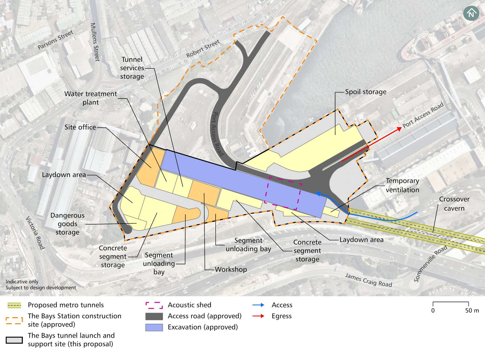
The Bays construction footprint

Traffic and Transport Changes
Construction on Sydney Metro West officially began in The Bays on 18 November 2020.
The road works at The Bays were assessed and approved through a Review of Environmental Factors process in 2020.
These works in The Bays include:
- Adjusting the intersection of Solomons Way / Sommerville Road / Port Access Road
- Tie-in works to the Port Access Road to the west of the adjusted intersection
- Converting Solomons Way / Sommerville Road into a one way circuit
- Relocating the Cement Australia Truck Parking Lisenced Area to the north-east
- Minor road verge widening works on Solomons Way.

Traffic network changes
Traffic and transport changes at the Bays are being assessed under the Review of Environmental Factors. The proposal would include phased improvements at the intersection of Port Access Road, Sommerville Road and Solomons Way (the White Bay intersection).
- Phase one – relocating White Bay intersection, including changes to line markings and signage and truck parking for Cement Australia.
- Phase two – potential relocation of Port Access Road subject to further design development and stakeholder engagement.
These works are proposed to be undertaken during the day and are not expected to impact traffic flows on public roads outside of White Bay.
High-voltage power routes

Tunnel boring machines and roadheaders used to construct tunnels, passages and caverns between Westmead and The Bays will require dedicated power sources. This means new cables will need to be installed between some metro sites and nearby substations or existing power sources.
The route will consolidate power supply works required from the Ausgrid Rozelle sub-transmission station to The Bays Station with the future requirements of other projects.
Power supply routes will generally be located within existing road reserves and under-boring may be used to minimise impacts on major roads or infrastructure.
The cables will be laid underground and construction will generally include:
- investigating sites to locate existing services and assess ground conditions
- digging trenches and installing conduits (plastic pipes) to hold the new cables
- filling trenches and resurfacing the areas in consultation with the local council
- installing one small electricity kiosk within each metro site.
Parking changes
During the proposed road relocation works at The Bays is subject to assessment under the Review of Environmental Factors, truck parking for Cement Australia would be relocated.
Haulage routes
Designated haulage routes will be used by trucks to transport materials to and from the construction site. Site access would be through James Craig Road via Port Access Road.
Haulage routes
Designated haulage routes will be used by trucks to transport materials to and from the construction site. Site access would be through James Craig Road via the Port Access Road, Sommerville Road and Solomons Way.
Noise mitigation
An acoustic shed and/or other acoustic measures will be in place at The Bays to mitigate potential temporary noise impacts.
Potential construction noise and vibration impacts will be managed in accordance with the Sydney Metro Construction Noise and Vibration Standard which aims to manage noise and vibration levels through feasible and reasonable measures. The Standard provides a process for the development of site or activity specific Construction Noise and Vibration Impact Statements, standard mitigation measures and additional mitigation measures to be implemented based on noise and vibration levels.
The Sydney Metro West team will consider alternative construction methods to help mitigate noise where possible and will work with the community to provide scheduled respite periods during which high noise or vibration activities are not undertaken.
Nearby projects
Sydney Metro is committed to working closely with other nearby projects, local councils, NSW Government agencies and stakeholders to manage and coordinate construction activities and traffic, to help minimise impacts on the community. Other projects near The Bays Station include:
Rozelle Interchange and the delivery of the future Rozelle Parklands
Nearby projects
Sydney Metro is committed to working closely with other nearby projects, local councils, NSW Government agencies and stakeholders to manage and coordinate construction activities and traffic, to help minimise impacts on the community. Other projects near The Bays Station to include:
Revitalisation of Blackwattle Bay
Western Harbour Tunnel and Warringah Freeway Upgrade
Glebe Island concrete batching plant and Multi-User Facility

Placemaking
The station at The Bays will be located between Glebe Island and White Bay Power Station with an entrance to the south of White Bay. It will provide direct access to the proposed future Bays Waterfront Promenade. The Bays Station will be the main transport link into this new precinct, as well as serving the communities of Balmain, Rozelle and Blackwattle Bay.
The decision to locate a station at The Bays will be the first step to unlocking the area’s potential and to ensure access for all. Sydney Metro is working with the Department of Planning, Industry and Environment to finalise a place strategy to guide the transformation of Bays West into the future.
Work started on this city shaping project at The Bays in 2020, with tunnel boring machines (TBMs) set to be in the ground in 2022. In March 2021, the project received its first major planning approval which includes work to tunnel between The Bays and Westmead.
This proposal will involve additional work within the existing construction site footprint at The Bays.
Placemaking
The Bays is identified in The Eastern City District Plan (Greater Sydney Commission, 2018c) as a place of urban renewal opportunity.
The Bays Station would anchor this future CBD through:
- high quality station and precinct design to support active streets, vibrant public areas and views to the harbour
- integration with the future precinct planning framework
- enhancing connections with The White Bay Power Station, White Bay and the Anzac Bridge
- an activated precinct around the station that encourages pedestrian movement pedestrian and cyclist link and easy interchanges with other transport services
Heritage
Management and mitigation measures will be used where impacts to heritage items have been identified.
This may include conservation and re-use of heritage fabric, and archiving and recording the item for future generations.
The proposal will have a direct impact on the landscape and yards around White Bay Power Station. This will not affect the building and the building will be protected during construction.
This site may contain potential Aboriginal and non-Aboriginal archaeological deposits. Any potential archaeological investigations will be undertaken as required in accordance with Heritage Council guidelines. Any potential Aboriginal archaeological remains found will be interpreted by an Aboriginal heritage specialist in consultation with registered Aboriginal parties.
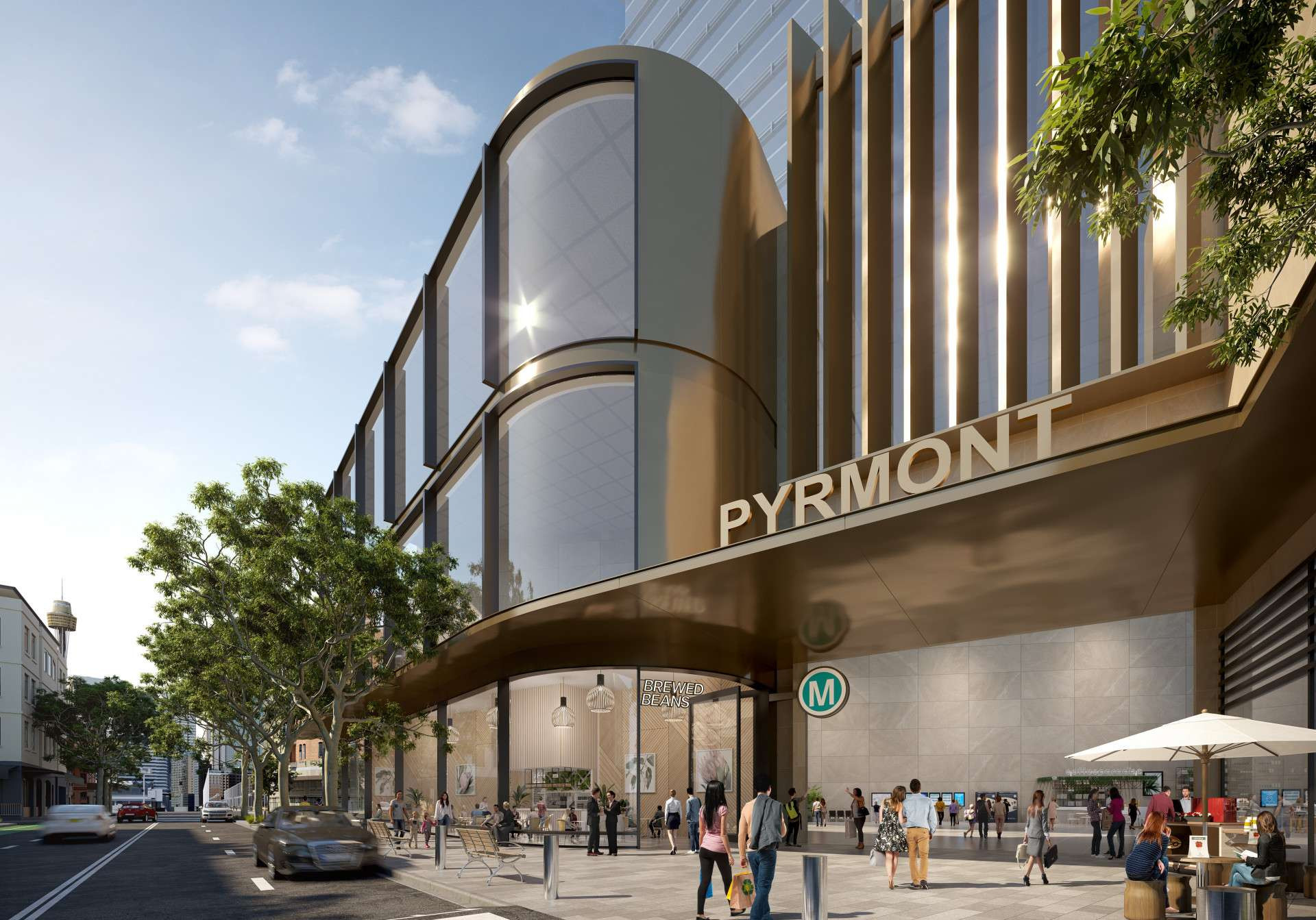
Pyrmont Station
The new Pyrmont Station will be on the doorstep of Darling Harbour, Blackwattle Bay, and the new Sydney Fish Market and the Sydney CBD. Station entrances are proposed to be located on Pyrmont Bridge Road and Union Street.
Pyrmont Station would greatly enhance plans to revitalise this inner city precinct by encouraging jobs, investment and economic growth. The station would enable a new level of connectivity to the Pyrmont Peninsula and prioritise pedestrian movement around the station through activated street frontages and open public spaces.
A Scoping Report for major civil construction work including station excavation and tunnelling between The Bays and Sydney CBD has now been submitted to the Department of Planning, Industry and Environment.
This report provides information on the proposed tunnel corridor, further proposed works, community consultation undertaken and the next steps in preparing a detailed Environmental Impact Statement, which is expected to be exhibited for community feedback later this year.
View the Sydney CBD and Pyrmont newsletter
Hunter Street Station
In the commercial heart of the Sydney CBD, the Hunter Street Station will become a new hub with easy connections to George Street, Light Rail, Sydney Trains services at Wynyard and Martin Place and the new Sydney Metro City & Southwest station at Martin Place.
A large activated precinct between George, Hunter, O’Connell and Bligh streets will prioritise pedestrians and support a vibrant public domain in the heart of the Sydney CBD. Station entrances are proposed to be located on Bligh, O’Connell and George streets.
A Scoping Report for major civil construction work including station excavation and tunnelling between The Bays and Sydney CBD has now been submitted to the Department of Planning, Industry and Environment.
This report provides information on the proposed tunnel corridor, further proposed works, community consultation undertaken and the next steps in preparing a detailed Environmental Impact Statement, which is expected to be exhibited for community feedback later this year.
View the Sydney CBD and Pyrmont newsletter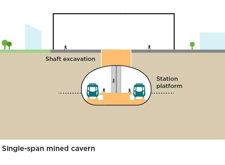
Station excavation
Pyrmont Station would be a single-span cavern of about 35 metres deep. A single span cavern means both tunnels enter the same cavern with a single central platform.
Placemaking
The new Pyrmont Station will be on the doorstep of Darling Harbour, Blackwattle Bay, the new Sydney Fish Market and the Sydney CBD. Station entrances are proposed to be located on Pyrmont Bridge Road and Union Street. Pyrmont Station will greatly enhance plans to revitalise this inner-city precinct by encouraging jobs, investment and economic growth.
The station will enable a new level of connectivity to the Pyrmont Peninsula and will prioritise pedestrian movement around the station through vibrant street frontages and open public spaces. Sydney Metro will continue to work with the Department of Planning, Industry and Environment, other government stakeholders and the community to ensure Pyrmont Station supports the future vision of the Pyrmont Peninsula.
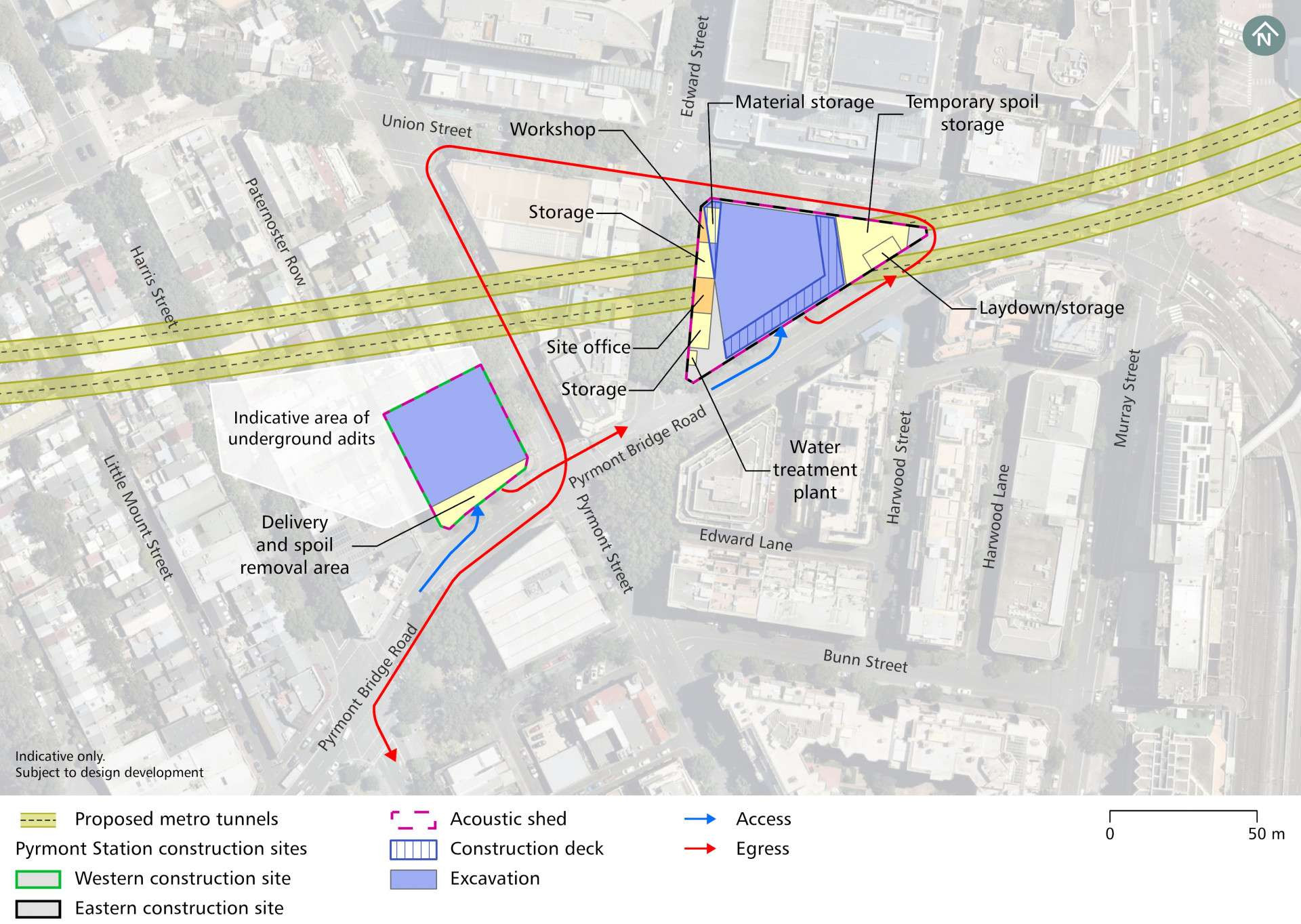
Construction footprint
Haulage routes
Designated haulage routes will be used by trucks to transport materials to and from the construction site. Site access to the western site will be from Pyrmont Bridge Road. Site access to the eastern site will be from Pyrmont Bridge Road, Union Street and/or Edward Street.
High-voltage power routes
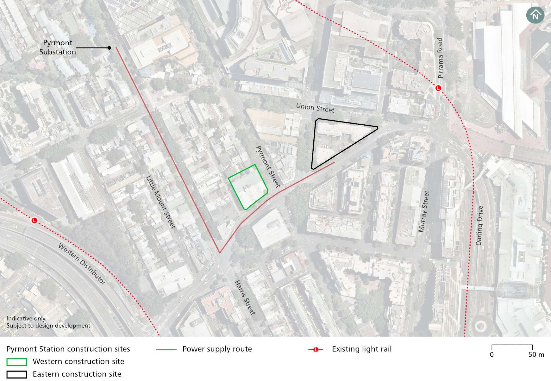
A new power supply route will be installed between Harris Street substation and the construction sites.
Nearby projects
Sydney Metro is committed to working closely with other nearby projects, local councils, NSW Government agencies and stakeholders to manage and coordinate construction activities and traffic, to help minimise impacts on the community. Other projects near Pyrmont Station include:
Parking changes
During construction there will be changes to parking on local streets.
There would be a temporary removal of both parking lanes along Union Street between Edward Street and Pyrmont Bridge Road.
Transport Changes
One bus stop on Pyrmont Bridge Road adjacent to the Pyrmont Station western construction site, not used by regular services, will be temporarily relocated.
Pedestrians and cyclists
Safety is our number one priority at Sydney Metro and appropriate controls will be established to ensure the safety of local communities. Where vehicles will be required to cross footpaths to access construction sites, manual supervision, physical barriers or temporary traffic lights will be used as required.
The following change to pedestrian and cyclists routes will occur at Pyrmont:
- Temporary diversion of the pedestrian footpath on the south side of Union Street between Edward Street and Pyrmont Bridge Road.
Heritage
Management and mitigation measures will be used where impacts to heritage items have been identified.
A building of potential local heritage significance within the western site will require demolition to facilitate construction. Archival reporting and recording will occur before construction.
Due to highly urbanised environments it is unlikely that Aboriginal and non-Aboriginal archaeological remains will be found.
Investigation work will be carried out prior to excavation work and any remains found will be interpreted by the relevant specialists.
Noise mitigation
An acoustic shed and/or other acoustic measures will be in place Pyrmont to mitigate potential temporary noise impacts.
Potential construction noise and vibration impacts will be managed in accordance with the Sydney Metro Construction Noise and Vibration Standard which aims to manage noise and vibration levels through feasible and reasonable measures. The Standard provides a process for the development of site or activity specific Construction Noise and Vibration Impact Statements, standard mitigation measures and additional mitigation measures to be implemented based on noise and vibration levels.
The Sydney Metro West team will consider alternative construction methods to help mitigate noise where possible and will work with the community to provide scheduled respite periods during which high noise or vibration activities are not undertaken.
Pyrmont Station
The new Pyrmont Station will be on the doorstep of Darling Harbour, Blackwattle Bay, and the new Sydney Fish Market and the Sydney CBD. Station entrances are proposed to be located on Pyrmont Bridge Road and Union Street.
Pyrmont Station would greatly enhance plans to revitalise this inner city precinct by encouraging jobs, investment and economic growth. The station would enable a new level of connectivity to the Pyrmont Peninsula and prioritise pedestrian movement around the station through activated street frontages and open public spaces.
A Scoping Report for major civil construction work including station excavation and tunnelling between The Bays and Sydney CBD has now been submitted to the Department of Planning, Industry and Environment.
This report provides information on the proposed tunnel corridor, further proposed works, community consultation undertaken and the next steps in preparing a detailed Environmental Impact Statement, which is expected to be exhibited for community feedback later this year.
View the Sydney CBD and Pyrmont newsletter
Hunter Street Station
In the commercial heart of the Sydney CBD, the Hunter Street Station will become a new hub with easy connections to George Street, Light Rail, Sydney Trains services at Wynyard and Martin Place and the new Sydney Metro City & Southwest station at Martin Place.
A large activated precinct between George, Hunter, O’Connell and Bligh streets will prioritise pedestrians and support a vibrant public domain in the heart of the Sydney CBD. Station entrances are proposed to be located on Bligh, O’Connell and George streets.
A Scoping Report for major civil construction work including station excavation and tunnelling between The Bays and Sydney CBD has now been submitted to the Department of Planning, Industry and Environment.
This report provides information on the proposed tunnel corridor, further proposed works, community consultation undertaken and the next steps in preparing a detailed Environmental Impact Statement, which is expected to be exhibited for community feedback later this year.
View the Sydney CBD and Pyrmont newsletter
Station excavation
Hunter Street Station would be a single-span cavern of an indicative depth of approximately 27 metres. A single span cavern means both tunnels enter the same cavern with a single central platform.
Placemaking
In the commercial heart of the Sydney CBD, the Hunter Street Station will become a new hub with easy connections to George Street, Light Rail, Sydney Trains services at Wynyard and Martin Place and the new Sydney Metro City & Southwest station at Martin Place. A large busy precinct between George, Hunter, O’Connell and Bligh streets will prioritise pedestrians and support a vibrant public domain in the heart of the Sydney CBD.
Station entrances are proposed to be located on George, O’Connell and Bligh streets. Proposed underground walkways will allow for easy transit all the way from Martin Place to Barangaroo, providing efficient links with Sydney Metro City & Southwest and Sydney Trains services.
The new station is expected to have the busiest city-bound platform across the entire Sydney rail network in the AM peak, taking pressure off Wynyard and Town Hall stations.
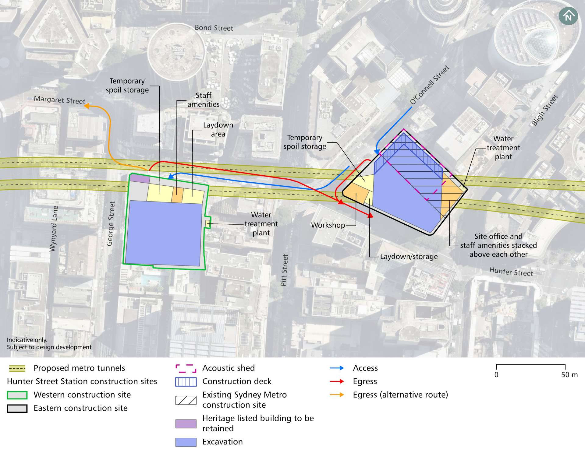
Construction footprint
Haulage routes
Designated haulage routes will be used by trucks to transport materials to and from the construction site. Site access to the western site will be from Hunter Street. Site access to the eastern site will be from O’Connell Street.
High-voltage power routes
A new power supply route will be installed between Harris Street substation and the construction sites.
Nearby projects
Sydney Metro is committed to working closely with other nearby projects, local councils, NSW Government agencies and stakeholders to manage and coordinate construction activities and traffic, to help minimise impacts on the community. Other projects near Pyrmont Station include:
Nearby projects
Sydney Metro is committed to working closely with other nearby projects, local councils, NSW Government agencies and stakeholders to manage and coordinate construction activities and traffic, to help minimise impacts on the community. Other projects near Hunter Street Station include:
Sydney Metro City & Southwest Martin Place Integrated Station Development
Parking changes
There would be a temporary removal of parking spaces on the south side of Hunter Street between George Street and Pitt Street adjacent to the Hunter Street western construction site. There would also be a temporary removal of parking spaces on the eastern side of O’Connell Street adjacent to the Hunter Street eastern construction site.
Permanent traffic changes
Sydney Metro will keep the road network moving during construction by adopting site-specific traffic management plans to minimise temporary impacts.
Permanent change:
- Permanent full closure of De Mestre Place
Pedestrians and cyclists
Safety is our number one priority at Sydney Metro and appropriate controls will be established to ensure the safety of local communities. Where vehicles will be required to cross footpaths to access construction sites, manual supervision, physical barriers or temporary traffic lights will be used as required.
The following change to pedestrian and cyclists routes will occur at Hunter Street:
- The underground pedestrian route from Wynyard to the Hunter Connection in the CBD will also be closed during construction. Pedestrians will be diverted to the surface, which will remain open.
- The cycle route on Pitt Street will be unaffected by our works.
Heritage
Heritage listed items within or directly adjacent to sites such as the Bennelong Sewer, the Tank Stream and the Former Skinners Family Hotel at Hunter Street will be retained and protected during construction.
Due to highly urbanised environments it is unlikely that Aboriginal and non-Aboriginal archaeological remains will be found.
Investigation work will be carried out prior to excavation work and any remains found will be interpreted by the relevant specialists.
Noise mitigation - Western site
Sydney Metro branded hoarding will be erected around the perimeter of the western construction site at Hunter Street Station to mitigate potential temporary noise impacts.
Potential construction noise and vibration impacts will be managed in accordance with the Sydney Metro Construction Noise and Vibration Standard which aims to manage noise and vibration levels through feasible and reasonable measures. The Standard provides a process for the development of site or activity specific Construction Noise and Vibration Impact Statements, standard mitigation measures and additional mitigation measures to be implemented based on noise and vibration levels.
The Sydney Metro West team will consider alternative construction methods to help mitigate noise where possible and will work with the community to provide scheduled respite periods during which high noise or vibration activities are not undertaken.
Noise mitigation - Eastern site
An acoustic shed and/or other acoustic measures will be in place at the eastern construction site at Hunter Street station to mitigate potential temporary noise impacts.
Potential construction noise and vibration impacts will be managed in accordance with the Sydney Metro Construction Noise and Vibration Standard which aims to manage noise and vibration levels through feasible and reasonable measures. The Standard provides a process for the development of site or activity specific Construction Noise and Vibration Impact Statements, standard mitigation measures and additional mitigation measures to be implemented based on noise and vibration levels.
The Sydney Metro West team will consider alternative construction methods to help mitigate noise where possible and will work with the community to provide scheduled respite periods during which high noise or vibration activities are not undertaken.

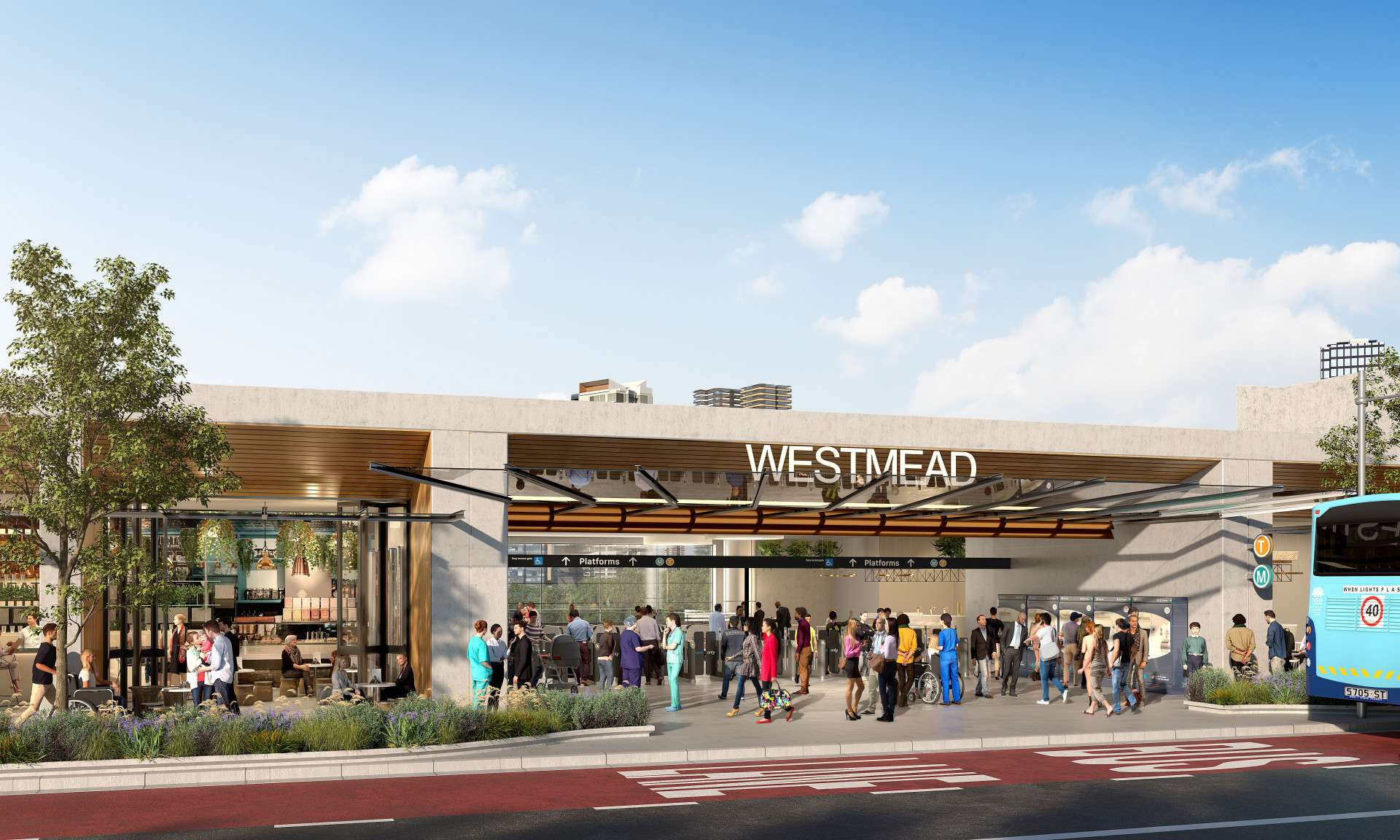
Westmead metro station
Westmead metro station will be a well connected and accessible health and education precinct, and a revitalized living and employment centre.
Adjacent station development is being considered to the south of the metro station, subject to a separate planning approval including community and stakeholder engagement.
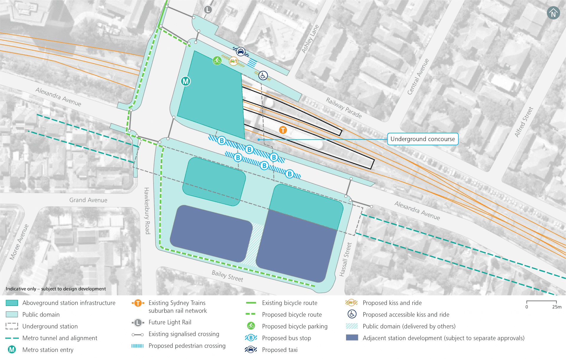
Operational precinct plan
Westmead construction footprint
Haulage routes
Continued site access arrangements are consistent with previous civil construction work:
- Bailey Street: via Hawkesbury Road: left-in
- Hawkesbury Road: left-out.
Additional site access:
- Hassall Street: right-in and potentially left-in
- Sydney Trains gates on Alexandra Avenue, Railway Parade and Bridge Road.
Traffic changes
Proposed traffic changes will be consistent with previous civil construction work including:
- Temporary removal of on-street parking spaces adjacent to the site along both Hassall Street and Bailey Street.
Additional temporary changes will include:
- Closure (around 12–18 months) of Alexandra Avenue and temporary traffic detour via Hassall Street, Bailey Street / Priddle Street and Hawkesbury Road
- Modification of traffic signals at Hawkesbury Road / Alexandra Avenue, Alexandra Avenue / Hassall Street and Hawkesbury Road / Bailey Street.
Sydney Metro is working with stakeholders on mitigation strategies for these changes.
Traffic network changes
Sydney Metro will keep the road network moving during construction by adopting site-specific traffic management plans to minimise temporary impacts. Works at Westmead metro station will involve a number of permanent and temporary traffic changes.
Temporary changes:
- Bailey Street - detour between Hawkesbury Road and Hassall Street around the closed section of Alexandra Avenue (see permanent changes to Alexandra Avenue)
- Hawkesbury Road / Alexandra Avenue - modification of traffic signals
- Alexandra Avenue / Hassall Street - modification of traffic signals
- Hawkesbury Road / Bailey Street - new traffic signals
Public transport changes
Temporary relocation of bus stops along Alexandra Avenue to Hassall Street, Bailey Street and Priddle Street (around 12–18 months) in consultation with Transport for NSW, local council and bus operators.
No impacts on the operation of the future light rail are anticipated.
Work within the rail corridor will generally be undertaken during scheduled Sydney Trains rail possessions.

Parking changes
Continued temporary removal of on-street parking next to the metro station site along Hassall and Bailey streets consistent with previous civil construction work.
Additional temporary removal of parking spaces to accommodate changes to traffic signals:
- Around four parking spaces at the Hawkesbury Road / Bailey Street intersection
- Around 10 parking spaces at the Hassall Street / Bailey Street intersection.
Additional temporary short-term removal (typically during weekend and holiday periods):
- Around 27 on-street parking spaces on Railway Parade (during rail possessions only)
- Around 50 on-street parking spaces on Alexandra Avenue west of Hawkesbury Road (during rail possessions only).
Additional permanent removal for new transport interchanges:
• Seven on-street parking spaces will be removed on Railway Parade to accommodate the new kiss and ride bays and point-to-point transport.
Pedestrian and cycling changes
No additional changes from the previous planning approval are required for most of the work period; however, short-term pedestrian access adjustments may be required.
Construction for new bus stops, and new traffic arrangements may require short-term closures of sections of footpaths.
Appropriate diversions will be established to safely guide pedestrians around work zones.
Noise mitigation
Across the project alignment, predicted operational noise levels are expected to be generally compliant with the applicable noise criteria set out in the relevant guidelines. Where required, mitigation measures will be included as part of the project design to ensure full compliance.
Potential overall noise impacts during construction are expected to be similar to those assessed in the Environmental Impact Statements for ‘Major civil construction work between Westmead and The Bays’ and ‘Major civil construction between The Bays and Sydney CBD’. We know that temporary noise impacts affect people differently and, depending on the location of new activities, some people may notice more noise and some people may notice less.
The Sydney Metro West team will consider alternative construction methods to help mitigate noise where possible and will work with the community to provide scheduled respite periods during which high noise or vibration activities are not undertaken.
Nearby projects
Sydney Metro is committed to working closely with other nearby projects, local councils, NSW Government agencies and stakeholders to manage and coordinate construction activities and traffic, to help minimise impacts on the community. Other projects near to Westmead metro station include:
Placemaking
Parramatta is identified in the Central City District Plan (Greater Sydney Commission, 2018b), as one of Australia’s most important CBDs and business hubs.
The Parramatta metro station will support strengthening of the Parramatta CBD through:
- high quality station and precinct design
- a strong city centre connection between Parramatta Square and the Parramatta River and integrating with the future Civic Link
- an activated precinct around the station that encourages pedestrian movement
- pedestrian and cyclist link and easy interchanges with other transport services
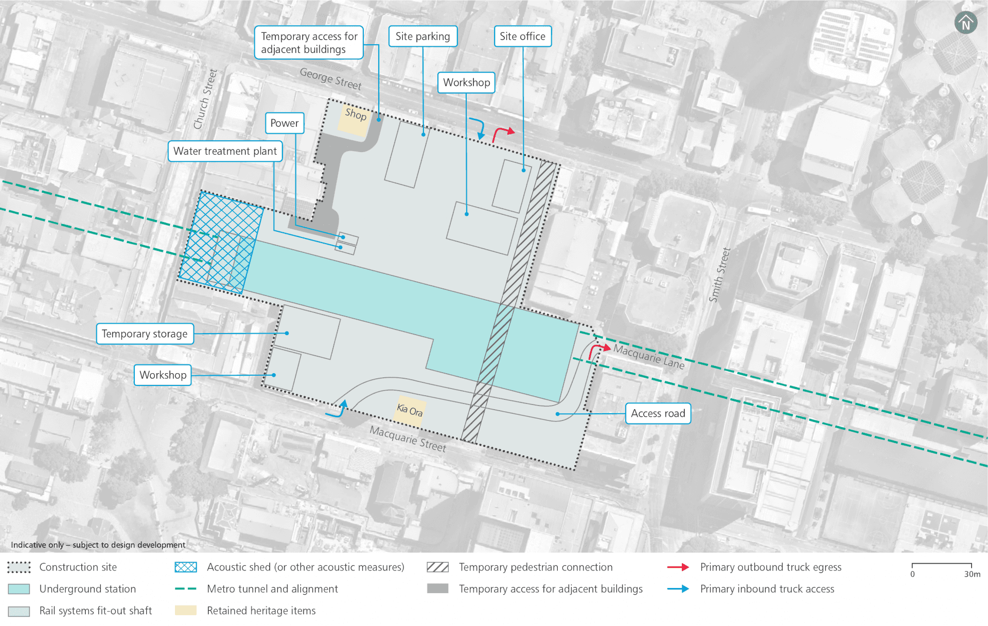
Parramatta construction footprint
Haulage routes
Continued site access arrangements consistent with previous civil construction work:
- George Street: right-in and left-out.
Additional site access:
- George Street: right-out
- Macquarie Street: left-in
- Macquarie Lane: left-out and then left-out onto Smith Street

Traffic changes
Proposed traffic changes will be consistent with the previous Sydney Metro West planning approval including:
- Permanent closure of Horwood Place
- Realignment of Macquarie Lane (and kept open) between Macquarie Street and Smith Street
- Construction traffic signals at George Street
- Temporary access arrangements to adjacent properties.
In addition, provision will be made for ongoing pedestrian access between George and Macquarie streets through the construction site.
Parking changes
Continued permanent removal of 35 on-street parking along Horwood Place and off-street parking accessed from Horwood Place, as identified in the previous planning approval.
Pedestrian and cycling changes
Continued changes to the active transport network established under the previous planning approval including:
- Closure of the north-south link along Horwood Place
- Closure of Batman Walk between Macquarie Street and Macquarie Lane.
Appropriate diversions will be established to safely guide pedestrians around work zones.
Heritage
Tunnelling works are not anticipated to impact on heritage items in Parramatta Park.
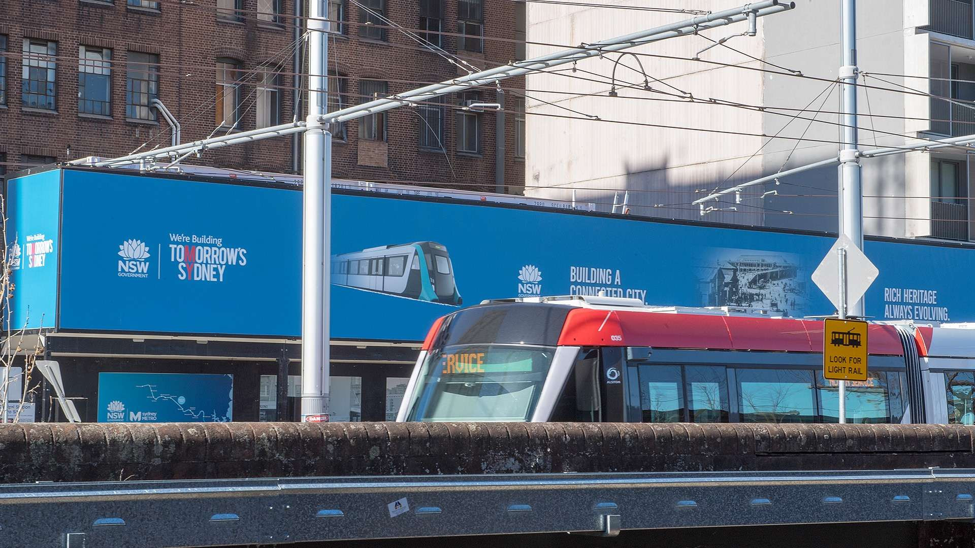
Noise mitigation
Across the project alignment, predicted operational noise levels are expected to be generally compliant with the applicable noise criteria set out in the relevant guidelines. Where required, mitigation measures will be included as part of the project design to ensure full compliance.
Potential overall noise impacts during construction are expected to be similar to those assessed in the Environmental Impact Statements for ‘Major civil construction work between Westmead and The Bays’ and ‘Major civil construction between The Bays and Sydney CBD’. We know that temporary noise impacts affect people differently and, depending on the location of new activities, some people may notice more noise and some people may notice less.
The Sydney Metro West team will consider alternative construction methods to help mitigate noise where possible and will work with the community to provide scheduled respite periods during which high noise or vibration activities are not undertaken.
An acoustic shed (or other acoustic measure) will be installed over the access shaft for tunnel fit-out and rail systems work.
Noise mitigation
Sydney Metro hoarding will be erected around the perimeter of the construction site to mitigate potential noise impacts.
Potential construction noise and vibration impacts will be managed in accordance with the Sydney Metro Construction Noise and Vibration Standard which aims to manage noise and vibration levels through feasible and reasonable measures. The Standard provides a process for the development of site or activity specific Construction Noise and Vibration Impact Statements, standard mitigation measures and additional mitigation measures to be implemented based on noise and vibration levels.
The Sydney Metro West team will consider alternative construction methods to help mitigate noise where possible and would work with the community to provide scheduled respite periods during which high noise or vibration activities are not undertaken.
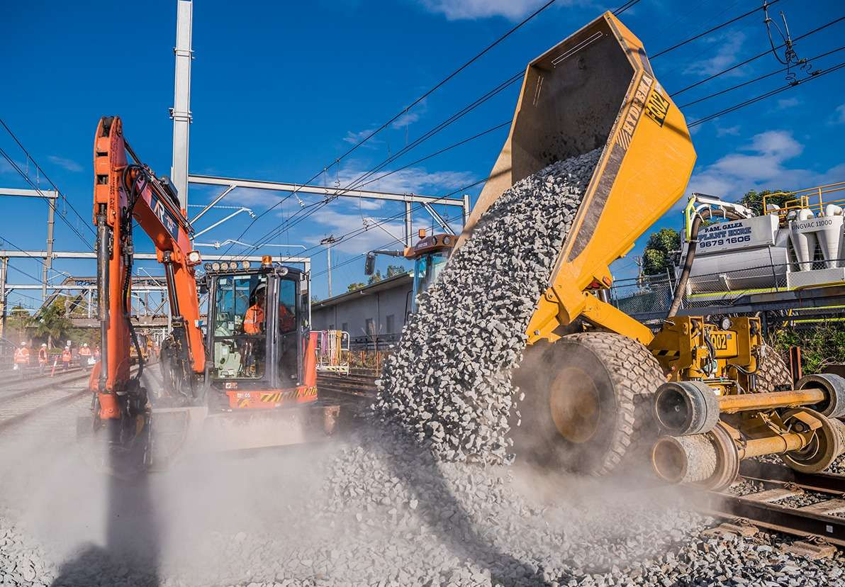
Nearby projects
Sydney Metro is committed to working closely with other nearby projects, local councils, NSW Government agencies and stakeholders to manage and coordinate construction activities and traffic, to help minimise impacts on the community. Other projects near to Parramatta metro station include:
Supporting services and infrastructure
The stabling and maintenance facility is located within the Clyde and Rosehill industrial area to the north of the M4 Western Motorway and to the east of James Ruse Drive. Duck Creek sits to the north and east of the site Metro trains will come and go from a dive structure to the north of the site, adjacent to James Ruse Drive. Vehicular access will be via Wentworth Street and Unwin Street.
Rail infrastructure
Just like the Metro North West Line, Sydney Metro West will use advanced world-class signalling technology to support safe operations and control the way trains accelerate and brake at stations.
The signalling and train control system, operating from the Clyde stabling and maintenance facility, will automate the metro trains, including train spacing and speed monitoring.
Communications equipment will be within the designated services area at each station and also within the tunnels and at the Clyde stabling and maintenance facility.
Access shafts will be constructed for tunnel fit-out and rail systems work at Parramatta metro station, Burwood North Station, The Bays Station and Clyde stabling and maintenance facility.
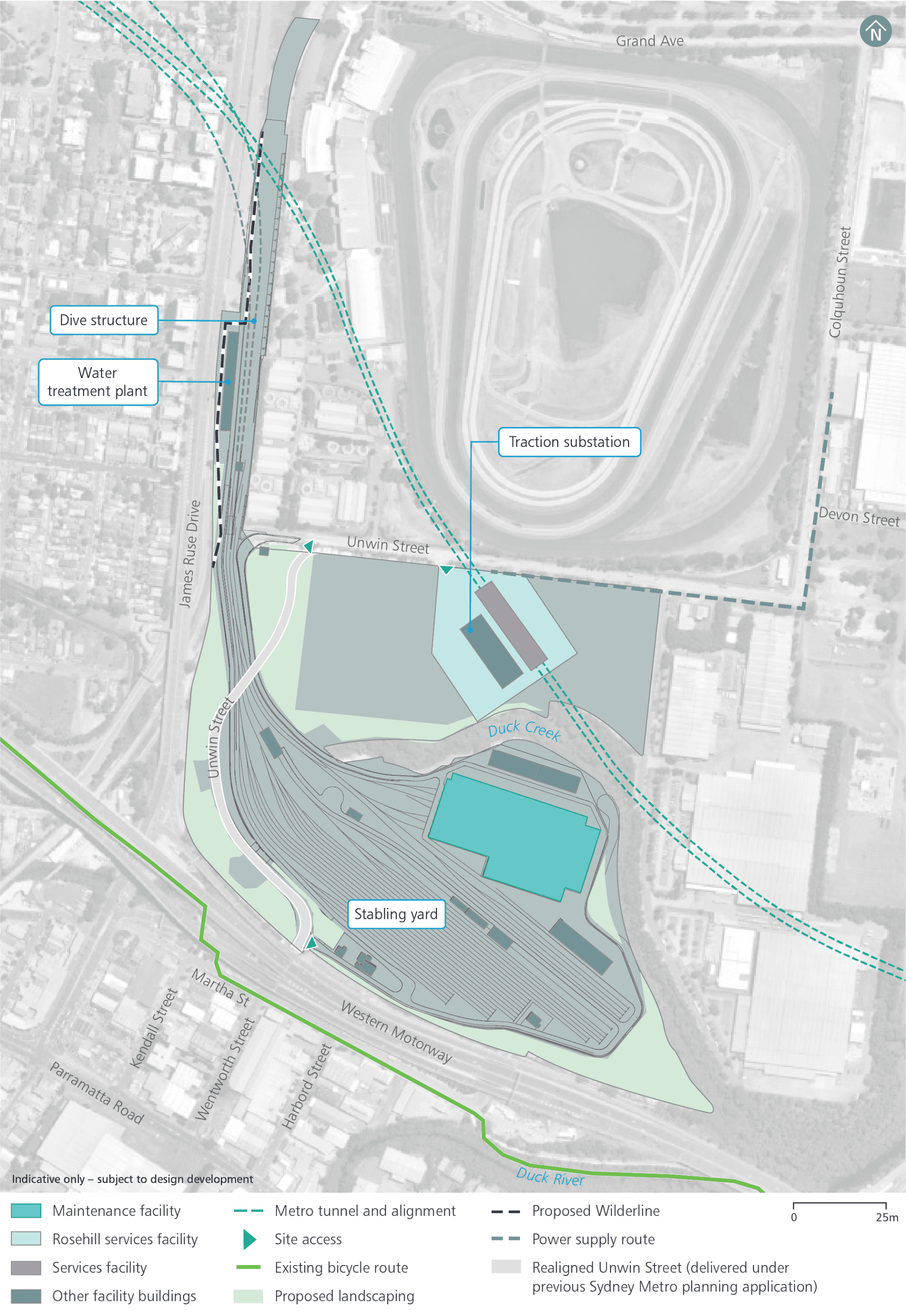
Operational precinct plan
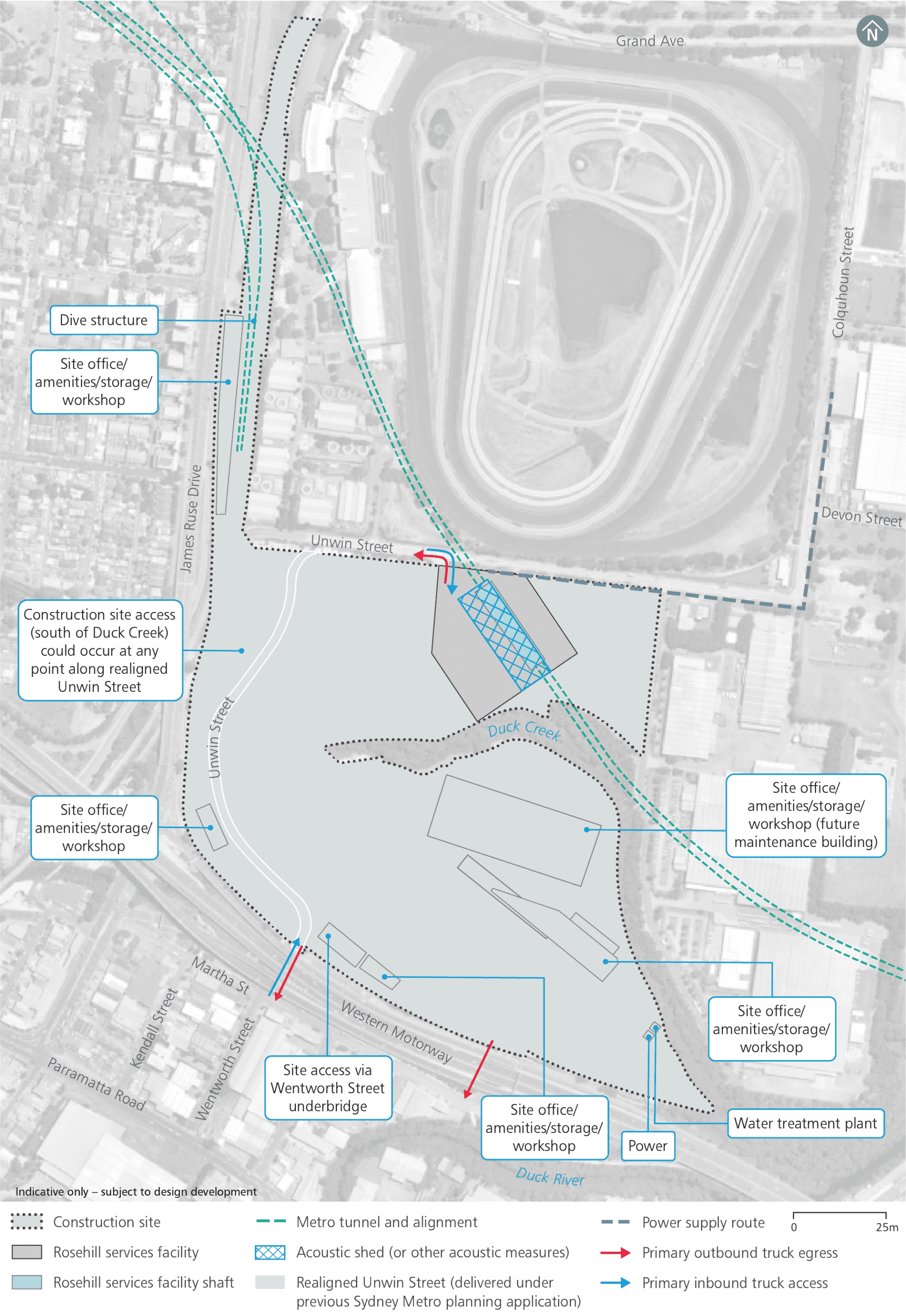
Clyde stabling and maintenance facility construction footprint
Haulage routes
Continued site access arrangements consistent with previous civil construction work:
- Wentworth Street.
Additional site access arrangements:
- Unwin Street: right-in, left-out
Traffic changes
Continued traffic changes involve permanent realignment of Unwin Street.
Pedestrian and cycling changes
Under the previous planning approval the footpath on the southern side of Unwin Street would be permanently closed and pedestrians would be advised to use the northern side of the road.
New permanent pedestrian access would also be provided to Rosehill Gardens racecourse from James Ruse Drive to replace the previous access over the former Rosehill Station.
Noise mitigation
Across the project alignment, predicted operational noise levels are expected to be generally compliant with the applicable noise criteria set out in the relevant guidelines. Where required, mitigation measures will be included as part of the project design to ensure full compliance.
Potential overall noise impacts during construction are expected to be similar to those assessed in the Environmental Impact Statements for ‘Major civil construction work between Westmead and The Bays’ and ‘Major civil construction between The Bays and Sydney CBD’. We know that temporary noise impacts affect people differently and, depending on the location of new activities, some people may notice more noise and some people may notice less.
The Sydney Metro West team will consider alternative construction methods to help mitigate noise where possible and will work with the community to provide scheduled respite periods during which high noise or vibration activities are not undertaken.
An acoustic shed (or other acoustic measure) will be established over the rail infrastructure access shaft at Rosehill services facility.
Placemaking
Sydney Olympic Park is identified in the Central City District Plan (Greater Sydney Commission, 2018b) as a State significant precinct.
The Sydney Olympic Park metro station will support the precinct through:
- reinforcing a new town centre to deliver a strong public domain
- facilitating the movements of visitors to major events
- providing an activated precinct around the station that encourages pedestrian movement and integration with active streets and open spaces
- allowing easy interchanges with other transport services.

Sydney Olympic Park metro station
Sydney Olympic Park metro station will be a thriving urban precinct with a vibrant mix of homes, jobs, and open spaces within a premier destination for cultural, entertainment, recreation, and sporting events.
Over and adjacent station development is proposed within the metro station precinct and is subject to a separate planning approval including community and stakeholder engagement.
Rail infrastructure
Just like the Metro North West Line, Sydney Metro West will use advanced world-class signalling technology to support safe operations and control the way trains accelerate and brake at stations.
The signalling and train control system, operating from the Clyde stabling and maintenance facility, will automate the metro trains, including train spacing and speed monitoring.
Communications equipment will be within the designated services area at each station and also within the tunnels and at the Clyde stabling and maintenance facility.
Access shafts will be constructed for tunnel fit-out and rail systems work at Parramatta metro station, Burwood North Station, The Bays Station and Clyde stabling and maintenance facility.
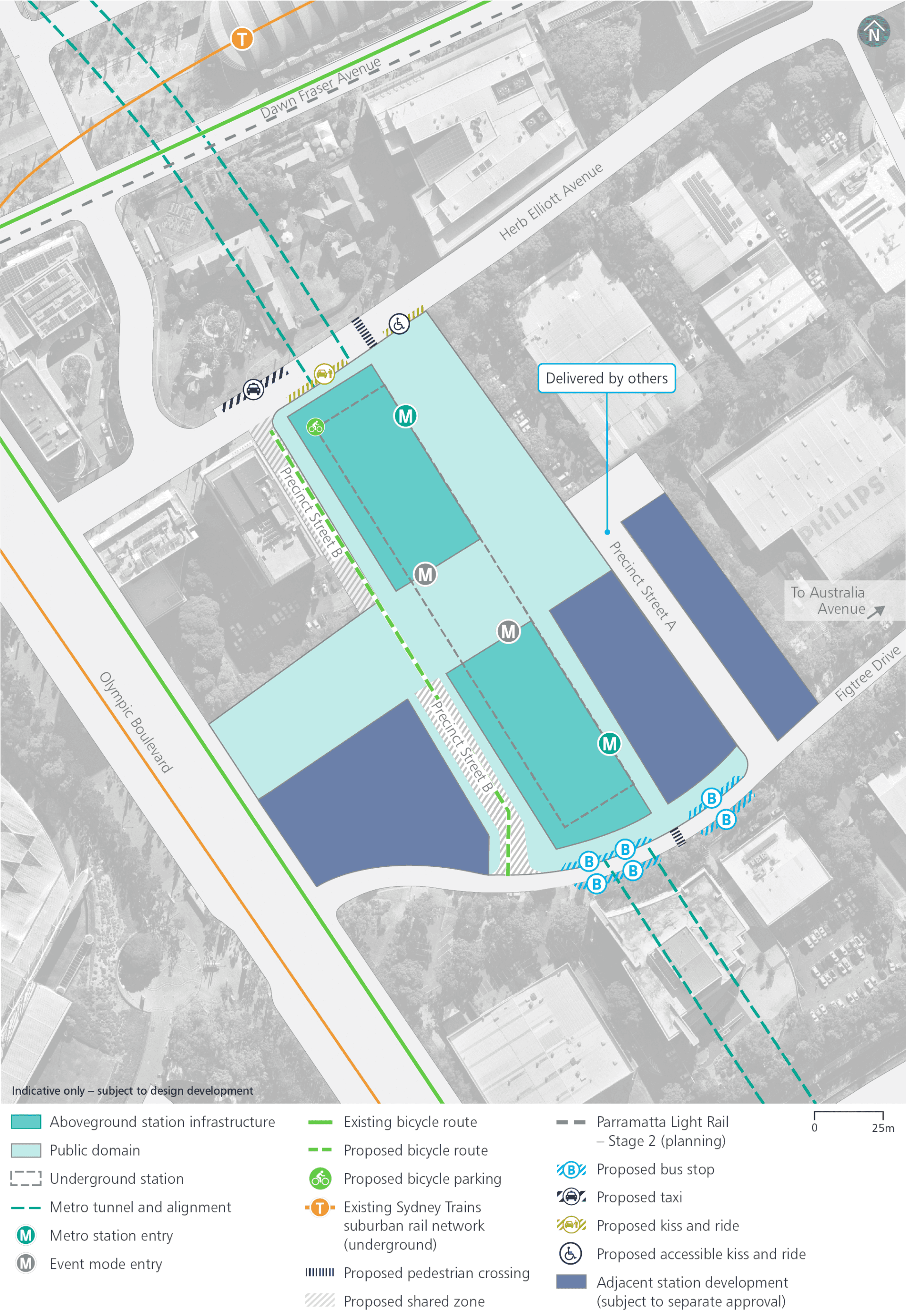
Operational precinct plan
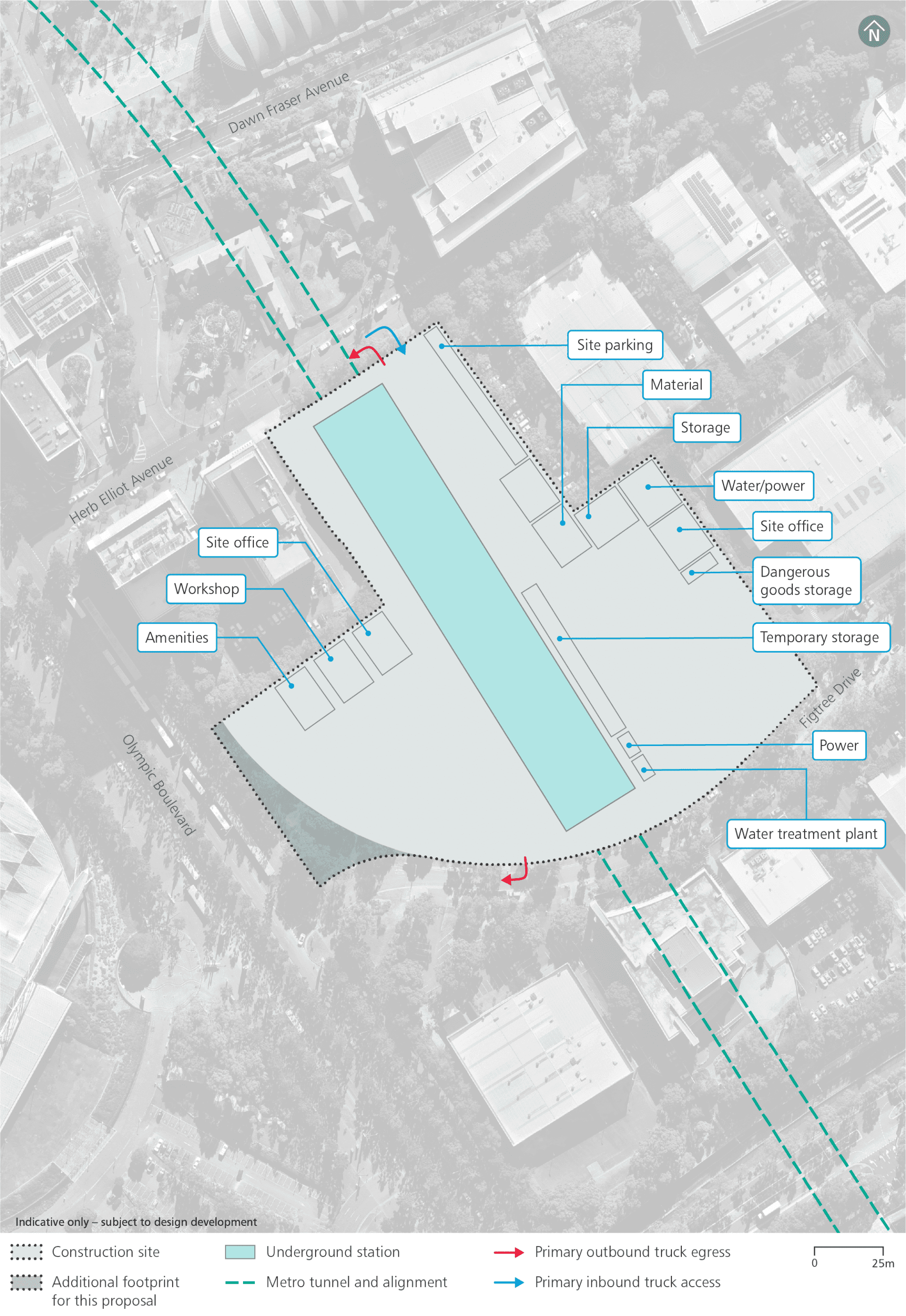
Construction footprint
Haulage routes
Continued site access arrangements consistent with previous civil construction work:
- Herb Elliot Avenue – left-in, right-out.
Additional site access:
- Herb Elliot Avenue – right-in, left-out
- Figtree Drive – right-in, right-out.
Pedestrians and cyclists
Safety is our number one priority at Sydney Metro and appropriate controls will be established to ensure the safety of local communities. Where vehicles will be required to cross footpaths to access construction sites, manual supervision, physical barriers or temporary traffic lights will be used as required.
The following change to pedestrian and cyclists routes will occur at Sydney Olympic Park:
- Showground Road - will become closed to cars and open to pedestrians and cyclists at the intersection with Dawn Fraser Avenue to facilitate access to the proposed northern station entry.
Traffic changes
No traffic changes are proposed under this proposal or the previous planning approval.
Traffic network changes
Sydney Metro will keep the road network moving during construction by adopting site-specific traffic management plans to minimise temporary impacts.
Transport changes
Construction work will require the temporary relocation of the taxi rank on Herb Elliot Avenue to a suitable location within the precinct in consultation with stakeholders.
There will be no changes to bus stops and bus routes in Sydney Olympic Park.
Noise mitigation
Across the project alignment, predicted operational noise levels are expected to be generally compliant with the applicable noise criteria set out in the relevant guidelines. Where required, mitigation measures will be included as part of the project design to ensure full compliance.
Potential overall noise impacts during construction are expected to be similar to those assessed in the Environmental Impact Statements for ‘Major civil construction work between Westmead and The Bays’ and ‘Major civil construction between The Bays and Sydney CBD’. We know that temporary noise impacts affect people differently and, depending on the location of new activities, some people may notice more noise and some people may notice less.
The Sydney Metro West team will consider alternative construction methods to help mitigate noise where possible and will work with the community to provide scheduled respite periods during which high noise or vibration activities are not undertaken.
Nearby projects
Sydney Metro is committed to working closely with other nearby projects, local councils, NSW Government agencies and stakeholders to manage and coordinate construction activities and traffic, to help minimise impacts on the community. Other projects near to Sydney Olympic Park metro station include:
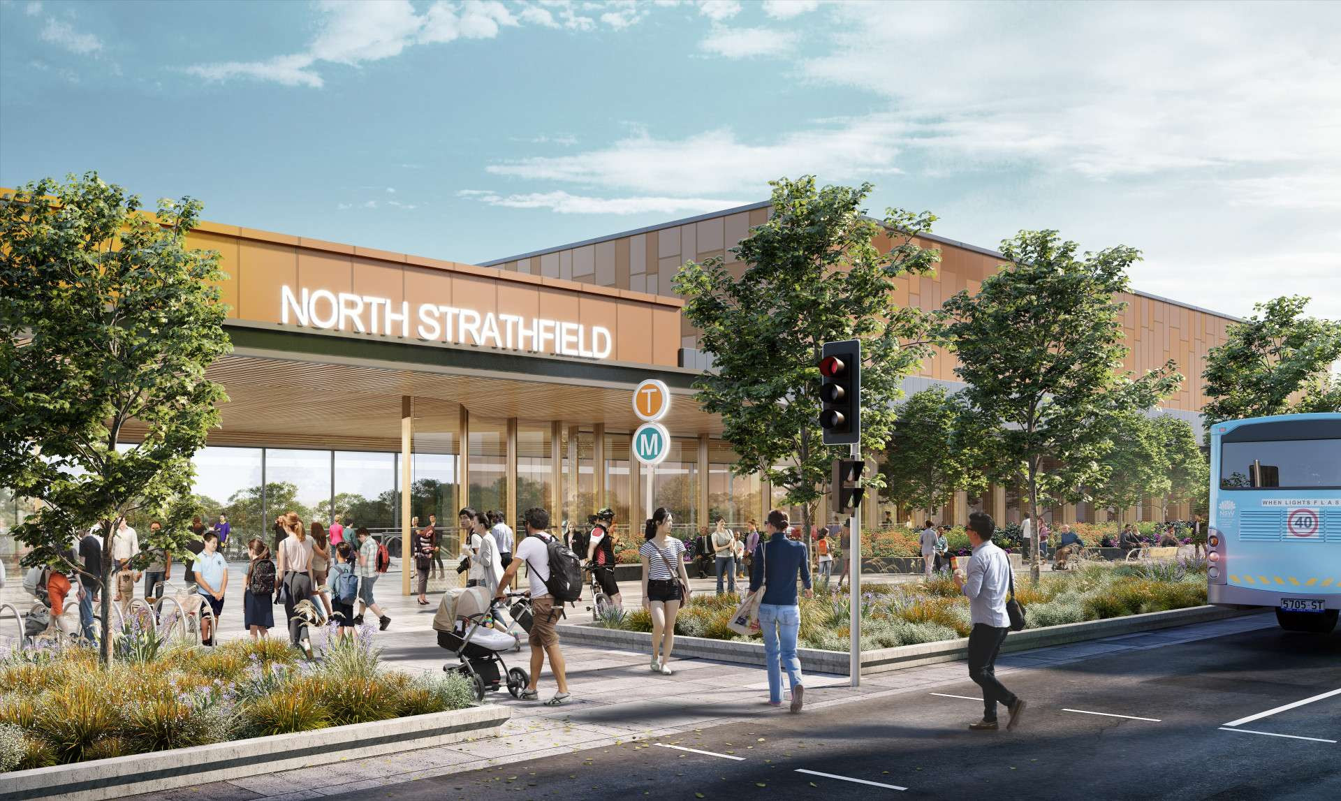
North Strathfield metro station
North Strathfield metro station will be a living precinct, well connected to Sydney's key employment and leisure destinations.
Rail infrastructure
Just like the Metro North West Line, Sydney Metro West will use advanced world-class signalling technology to support safe operations and control the way trains accelerate and brake at stations.
The signalling and train control system, operating from the Clyde stabling and maintenance facility, will automate the metro trains, including train spacing and speed monitoring.
Communications equipment will be within the designated services area at each station and also within the tunnels and at the Clyde stabling and maintenance facility.
Access shafts will be constructed for tunnel fit-out and rail systems work at Parramatta metro station, Burwood North Station, The Bays Station and Clyde stabling and maintenance facility.
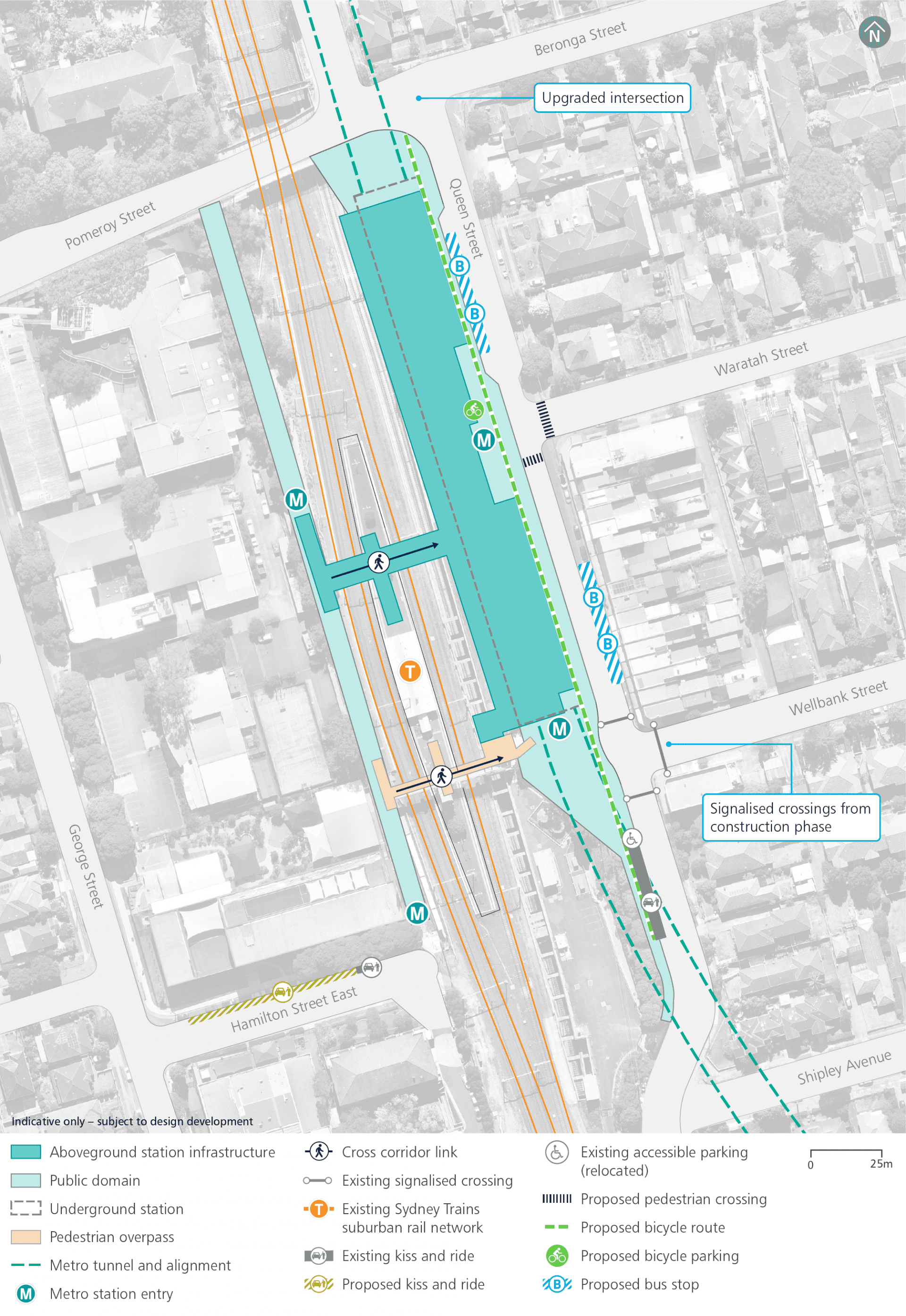
Operational precinct plan
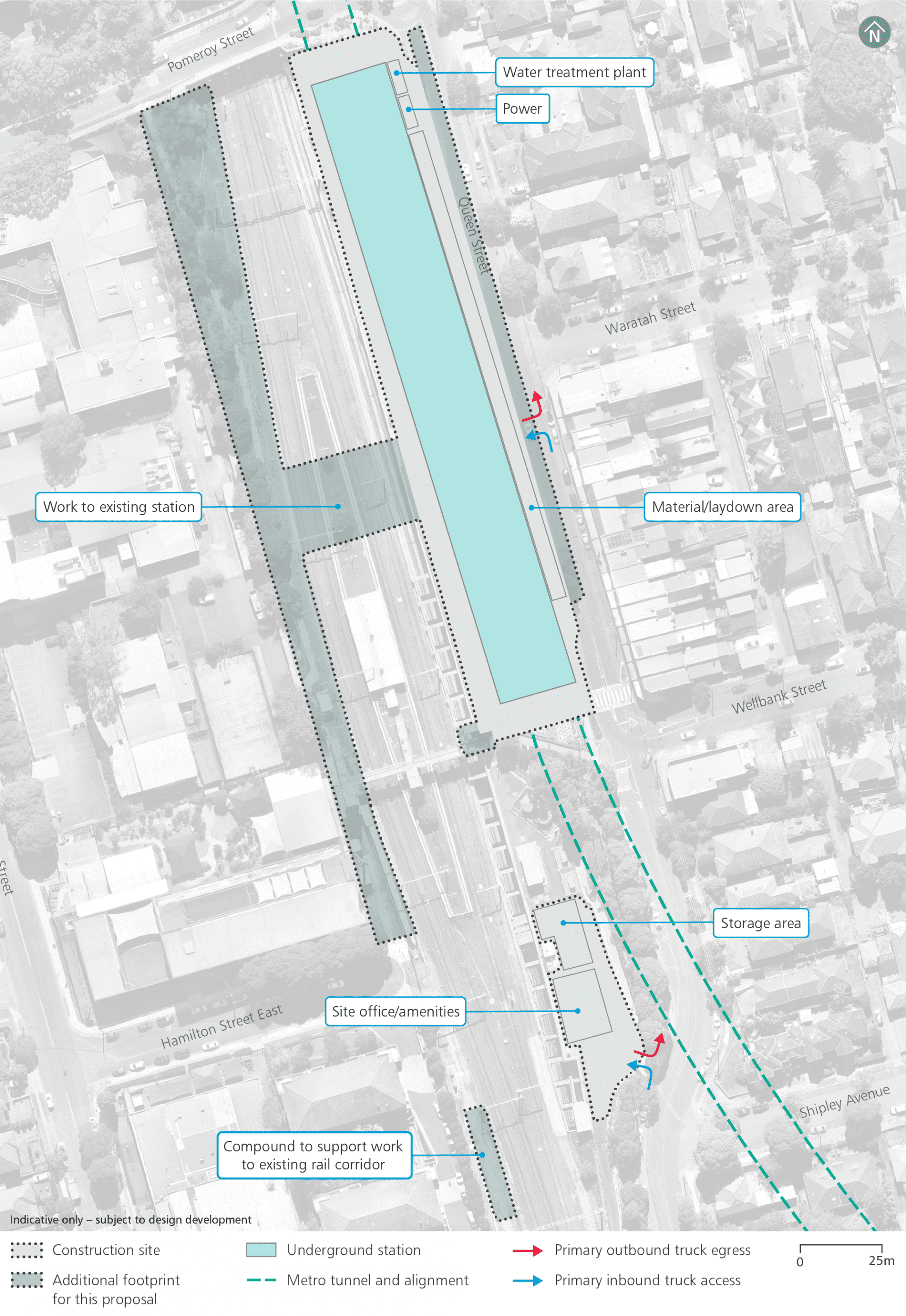
North Strathfield construction footprint
Haulage routes
Continued site access arrangements consistent with previous civil construction work:
- Queen Street: left-in, right-out
Additional site access:
- Queen Street and Hamilton Street East: existing rail corridor gates.
- Between Strathfield Station and Rhodes Station: other existing rail corridor gates may be used on occasion.
Traffic changes
Additional modifications including:
- Temporary relocation of the kiss and ride bays on the western side of Queen Street, between Wellbank Street and Pomeroy Street
- Temporary relocation of the existing school bus stops on the western and eastern sides of Queen Street, north of Wellbank Street
- Permanent new traffic signals at the Queen Street / Wellbank Street intersection
- Permanent changes to Queen Street / Beronga Street / Pomeroy Street intersection, in consultation with stakeholders.
Parking changes
Continued parking changes including:
- Permanent removal of around 20 on-street parking spaces on the western side of Queen Street between Wellbank Street and Pomeroy Street
- Temporary relocation of the kiss and ride bays on the western side of Queen Street between Wellbank Street and Pomeroy Street.
Additional parking changes during construction and operation including:
- Permanent removal of around 20 car parking spaces on the eastern sides of Queen Street between Wellbank Street and Pomeroy Street.
Public transport changes
No additional impacts on the operation of buses or trains, as per the previous planning approval, are anticipated.
Work within the rail corridor will generally be undertaken during scheduled Sydney Trains rail possessions.
Noise mitigation
Across the project alignment, predicted operational noise levels are expected to be generally compliant with the applicable noise criteria set out in the relevant guidelines. Where required, mitigation measures will be included as part of the project design to ensure full compliance.
Potential overall noise impacts during construction are expected to be similar to those assessed in the Environmental Impact Statements for ‘Major civil construction work between Westmead and The Bays’ and ‘Major civil construction between The Bays and Sydney CBD’. We know that temporary noise impacts affect people differently and, depending on the location of new activities, some people may notice more noise and some people may notice less.
The Sydney Metro West team will consider alternative construction methods to help mitigate noise where possible and will work with the community to provide scheduled respite periods during which high noise or vibration activities are not undertaken.
Nearby projects
Sydney Metro is committed to working closely with other nearby projects, local councils, NSW Government agencies and stakeholders to manage and coordinate construction activities and traffic, to help minimise impacts on the community. Other projects near to North Strathfield metro station include:
Priority growth areas and precincts – Burwood, Strathfield and Homebush
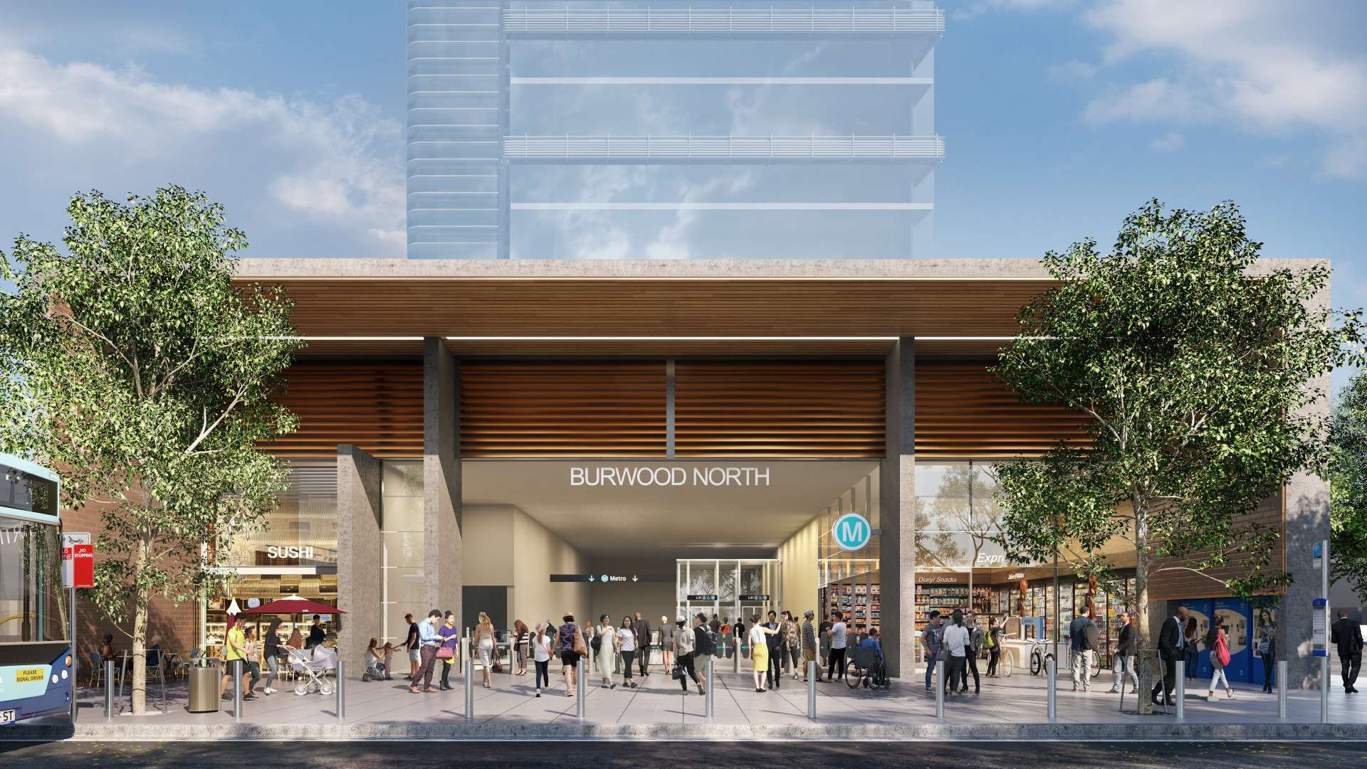
Burwood North metro station
Burwood North Station will be a residential and employment precinct centred on Parramatta and Burwood roads, supporting Burwood as a strategic centre.
Adjacent station development is being considered to the north of the metro station, subject to a separate planning approval including community and stakeholder engagement.
Spaces that could be used for retail, commercial and/or community facilities are included as part of this proposal. The future fit-out and use of these spaces will be subject to a separate planning approval including community and stakeholder engagement.
Rail infrastructure
Just like the Metro North West Line, Sydney Metro West will use advanced world-class signalling technology to support safe operations and control the way trains accelerate and brake at stations.
The signalling and train control system, operating from the Clyde stabling and maintenance facility, will automate the metro trains, including train spacing and speed monitoring.
Communications equipment will be within the designated services area at each station and also within the tunnels and at the Clyde stabling and maintenance facility.
Access shafts will be constructed for tunnel fit-out and rail systems work at Parramatta metro station, Burwood North Station, The Bays Station and Clyde stabling and maintenance facility.
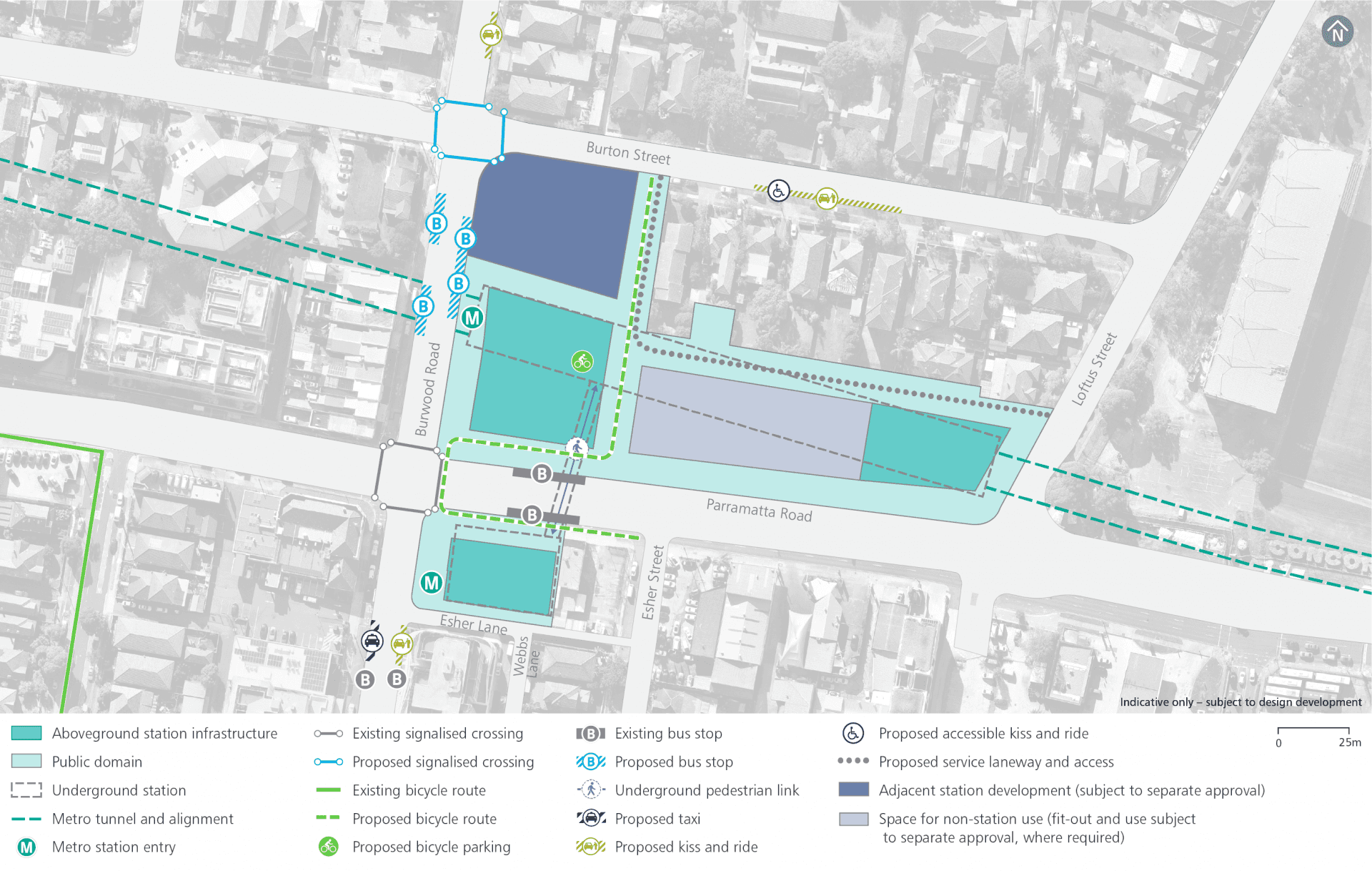
Operational precinct plan
Placemaking
Burwood is identified as a strategic centre in the Eastern City District Plan (Greater Sydney Commission, 2018c).
Burwood North Station will support the growth of the centre through:
- high quality precinct improvements to the north and south of Parramatta Road supporting Parramatta Road Corridor Urban Transformation Strategy
- facilitation of new places for people to live, work and socialise
- an activated precinct around the station that encourages pedestrian movement
- easy interchanges with other transport services
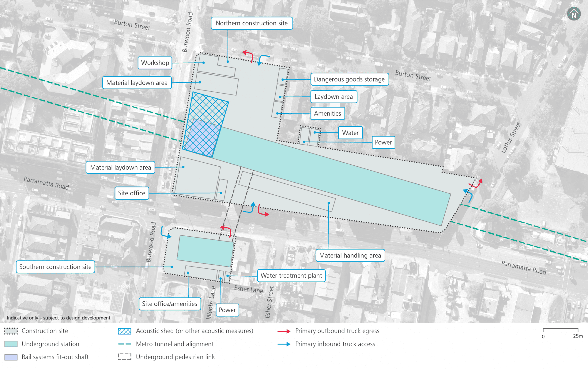
Construction footprint
Haulage routes
Continued site access arrangements consistent with previous civil construction work:
- Parramatta Road, Burton Street and Loftus Street: left-in and left-out
Potential additional site access:
- Burwood Road: left-out
Parking changes
Temporary removal during construction:
- About 22 on-street parking spaces on the southern side of Burton Street between Loftus Street and Burwood Road.
- Two on-street parking spaces on the eastern side of Loftus Street
- Two spaces on Burton Street along the northern kerb to accommodate a no stopping zone and kerb setbacks
Additional temporary parking removal during construction:
- Around seven spaces along the southern side of Burton Street to accommodate the kiss and ride bays (these spaces will be temporarily removed to facilitate excavation work)
Additional parking removal which would be required to be permanently removed for operation:
- Seven on-street parking spaces on the western side of Loftus Street to provide access and egress to the new laneway
- About 10 spaces on the western side of Burwood Road to accommodate two new bus stops
- Around five spaces on the eastern side of Burwood Road to accommodate two new bus stops
Public transport changes
Additional* temporary relocation of the bus stop along the southern side of Parramatta Roadin consultation with Transport for NSW, the local council and bus operators.
*The previous planning approval identified the need for temporary relocation of two bus stopson Parramatta Road and Burwood Road.
Noise mitigation
Across the project alignment, predicted operational noise levels are expected to be generally compliant with the applicable noise criteria set out in the relevant guidelines. Where required, mitigation measures will be included as part of the project design to ensure full compliance.
Potential overall noise impacts during construction are expected to be similar to those assessed in the Environmental Impact Statements for ‘Major civil construction work between Westmead and The Bays’ and ‘Major civil construction between The Bays and Sydney CBD’. We know that temporary noise impacts affect people differently and, depending on the location of new activities, some people may notice more noise and some people may notice less.
The Sydney Metro West team will consider alternative construction methods to help mitigate noise where possible and will work with the community to provide scheduled respite periods during which high noise or vibration activities are not undertaken.
An acoustic shed (or other acoustic measures) will be established over the access shaft for tunnel fit-out and rail systems work.
Nearby projects
Sydney Metro is committed to working closely with other nearby projects, local councils, NSW Government agencies and stakeholders to manage and coordinate construction activities and traffic, to help minimise impacts on the community. Other projects near to Burwood North Station include:
Placemaking
Five Dock is identified in The Eastern City District Plan (Greater Sydney Commission, 2018c) as a local centre.
Five Dock Station will support the community town centre through:
- contributing to the local town centre public domain, including activating Fred Kelly Place and supporting the principles of the Five Dock Town Centre Urban Design Study
- encouraging pedestrian movement between Great North Road and Fred Kelly Place
- promoting connectivity to and from the station through streets, lanes and public places
- easy interchanges with other transport services
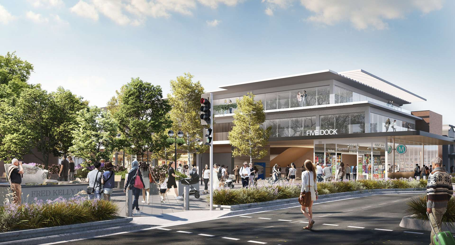
Five Dock Station
Five Dock Station will be a community-centred precinct that contributes to the character and identity of Five Dock as a diverse and vibrant local centre, well connected by new transport.
No over and/or adjacent station development is planned.
Spaces that could be used for retail, commercial and/or community facilities are included as part of this proposal. The future fit-out and use of these spaces will be subject to a separate planning approval including community and stakeholder engagement.
Rail infrastructure
Just like the Metro North West Line, Sydney Metro West will use advanced world-class signalling technology to support safe operations and control the way trains accelerate and brake at stations.
The signalling and train control system, operating from the Clyde stabling and maintenance facility, will automate the metro trains, including train spacing and speed monitoring.
Communications equipment will be within the designated services area at each station and also within the tunnels and at the Clyde stabling and maintenance facility.
Access shafts will be constructed for tunnel fit-out and rail systems work at Parramatta metro station, Burwood North Station, The Bays Station and Clyde stabling and maintenance facility.
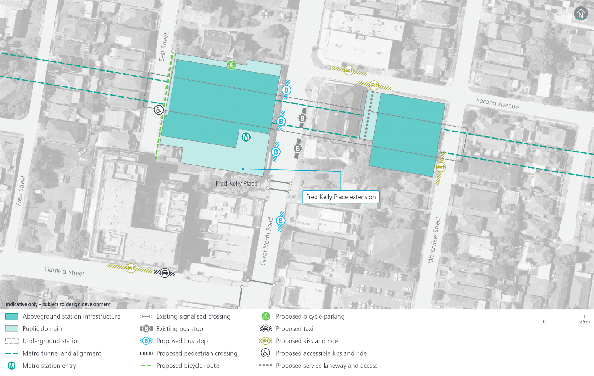
Operational precinct plan
Five Dock construction footprint
Haulage routes
Continued site access arrangements will be consistent with previous civil construction work.
Eastern construction site:
- Waterview Street: left-in, left out
- Second Avenue: left-out
Sydney Metro will undertake further investigations into alternative egress from the eastern construction site in consultation with the local council:
- Western construction site
- Great North Road: left-in, left-out
Traffic changes
Continued temporary transport network modifications including:
- Waterview Street one-way northbound from main car park to Second Avenue
- Second Avenue one-way westbound from Second Avenue to Great North Road.
Parking changes
Continued parking changes include temporary removal of parking spaces during construction:
- About 12 on-street parking spaces along the western side of Great North Road
- About 10 on-street parking spaces along the western side of Waterview Street and southern side of Second Avenue
Additional permanent parking changes for station access and interchange:
- Three spaces, including one accessible parking space on East Street, to accommodate access to the station loading dock
- About 12 on-street parking spaces along the western side of Great North Road to facilitate a bus stop
- About two spaces along the southern side of Second Avenue west of Waterview Street to accommodate the new kiss and ride bay
- About three spaces, including one accessible parking space on East Street, to accommodate access to the station loading dock
Parking spaces planned to be converted into kiss and ride spaces during AM and PM peak hours only including:
- About five spaces on Second Avenue (between Great North Road and Waterview Street)
- About three spaces on Waterview Street
- About two spaces on Garfield Street
Noise mitigation
Across the project alignment, predicted operational noise levels are expected to be generally compliant with the applicable noise criteria set out in the relevant guidelines. Where required, mitigation measures will be included as part of the project design to ensure full compliance.
Potential overall noise impacts during construction are expected to be similar to those assessed in the Environmental Impact Statements for ‘Major civil construction work between Westmead and The Bays’ and ‘Major civil construction between The Bays and Sydney CBD’. We know that temporary noise impacts affect people differently and, depending on the location of new activities, some people may notice more noise and some people may notice less.
The Sydney Metro West team will consider alternative construction methods to help mitigate noise where possible and will work with the community to provide scheduled respite periods during which high noise or vibration activities are not undertaken.
Nearby projects
Sydney Metro is committed to working closely with other nearby projects, local councils, NSW Government agencies and stakeholders to manage and coordinate construction activities and traffic, to help minimise impacts on the community. Other projects near to Five Dock Station include:
Placemaking
The station at The Bays will be located between Glebe Island and White Bay Power Station with an entrance to the south of White Bay. It will provide direct access to the proposed future Bays Waterfront Promenade. The Bays Station will be the main transport link into this new precinct, as well as serving the communities of Balmain, Rozelle and Blackwattle Bay.
The decision to locate a station at The Bays will be the first step to unlocking the area’s potential and to ensure access for all. Sydney Metro is working with the Department of Planning, Industry and Environment to finalise a place strategy to guide the transformation of Bays West into the future.
Work started on this city shaping project at The Bays in 2020, with tunnel boring machines (TBMs) set to be in the ground in 2022. In March 2021, the project received its first major planning approval which includes work to tunnel between The Bays and Westmead.
This proposal will involve additional work within the existing construction site footprint at The Bays.
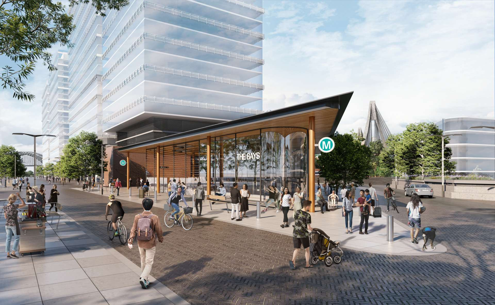
The Bays Station
The Bays Station will be a new mixed-use innovation precinct including employment, civic, retail and residential activities in a harbour-side setting.
Adjacent station development is being considered subject to the Bays West Place Strategy and separate planning approval including community and stakeholder engagement.
Spaces that could be used for retail, commercial and/or community facilities are included as part of this proposal. The future fit-out and use of these spaces will be subject to a separate planning approval including community and stakeholder engagement.
Rail infrastructure
Just like the Metro North West Line, Sydney Metro West will use advanced world-class signalling technology to support safe operations and control the way trains accelerate and brake at stations.
The signalling and train control system, operating from the Clyde stabling and maintenance facility, will automate the metro trains, including train spacing and speed monitoring.
Communications equipment will be within the designated services area at each station and also within the tunnels and at the Clyde stabling and maintenance facility.
Access shafts will be constructed for tunnel fit-out and rail systems work at Parramatta metro station, Burwood North Station, The Bays Station and Clyde stabling and maintenance facility.
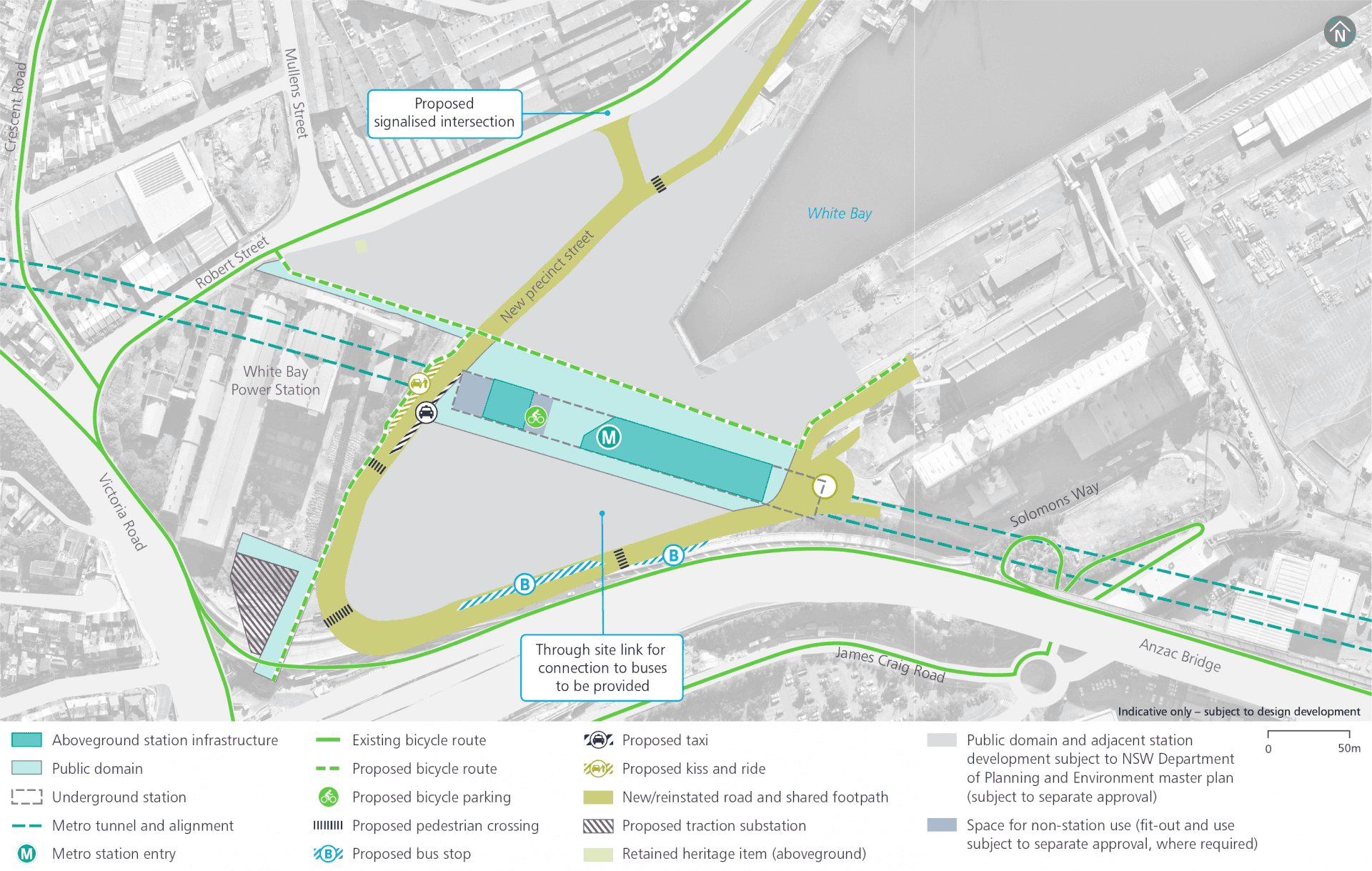
Operational precinct plan
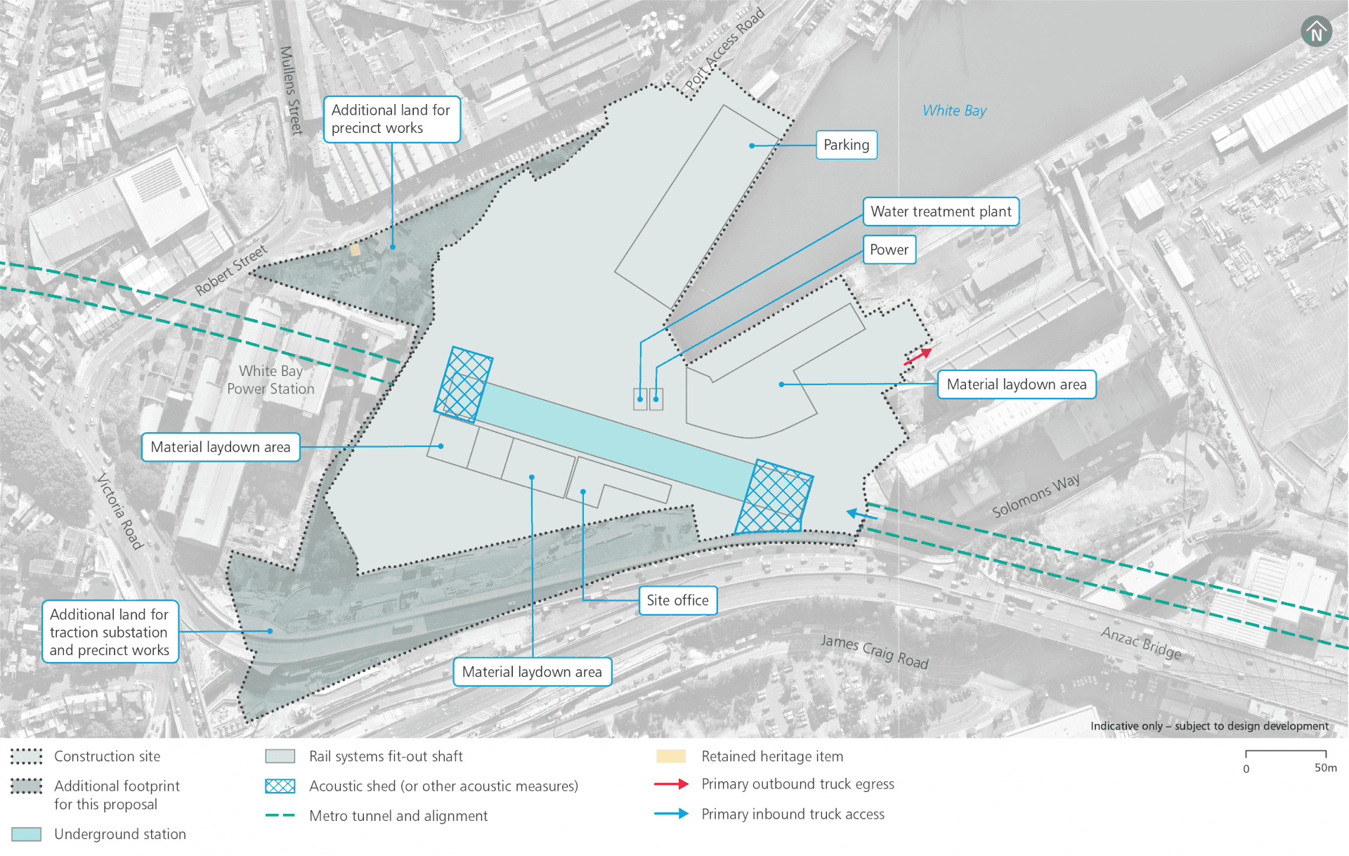
The Bays construction footprint
Haulage routes
Continued site access arrangements consistent with previous civil construction work:
- James Craig Road and Solomons Way / Port Access Road: in
- James Craig Road and Solomons Way / Port Access Road, through to Sommerville Road: out
Additional site access arrangements include:
- Robert Street: right-in, left-out.
Noise mitigation
Across the project alignment, predicted operational noise levels are expected to be generally compliant with the applicable noise criteria set out in the relevant guidelines. Where required, mitigation measures will be included as part of the project design to ensure full compliance.
Potential overall noise impacts during construction are expected to be similar to those assessed in the Environmental Impact Statements for ‘Major civil construction work between Westmead and The Bays’ and ‘Major civil construction between The Bays and Sydney CBD’. We know that temporary noise impacts affect people differently and, depending on the location of new activities, some people may notice more noise and some people may notice less.
The Sydney Metro West team will consider alternative construction methods to help mitigate noise where possible and will work with the community to provide scheduled respite periods during which high noise or vibration activities are not undertaken.
An acoustic shed (or other acoustic measures) will be installed over the access shaft for tunnel fit-out and rail systems work.
Nearby projects
Sydney Metro is committed to working closely with other nearby projects, local councils, NSW Government agencies and stakeholders to manage and coordinate construction activities and traffic, to help minimise impacts on the community. Other projects near to The Bays Station include:
Western Harbour Tunnel and Warringah Freeway Upgrade
Traffic changes
Additional* temporary traffic changes involve a new intersection and line-marking on Robert Street.
*Road works at Port Access Road and Solomons Way were undertaken as part of a separate planning approval process.
Parking changes
There will be no continued parking changes under the previous planning approvals.
To accommodate the proposed road network changes on Robert Street east of Mullens Street, parking spaces will be reduced from 124 to around 52.
Placemaking
The new Pyrmont Station will be on the doorstep of Darling Harbour, Blackwattle Bay, the new Sydney Fish Market and the Sydney CBD. Station entrances are proposed to be located on Pyrmont Bridge Road and Union Street. Pyrmont Station will greatly enhance plans to revitalise this inner-city precinct by encouraging jobs, investment and economic growth.
The station will enable a new level of connectivity to the Pyrmont Peninsula and will prioritise pedestrian movement around the station through vibrant street frontages and open public spaces. Sydney Metro will continue to work with the Department of Planning, Industry and Environment, other government stakeholders and the community to ensure Pyrmont Station supports the future vision of the Pyrmont Peninsula.
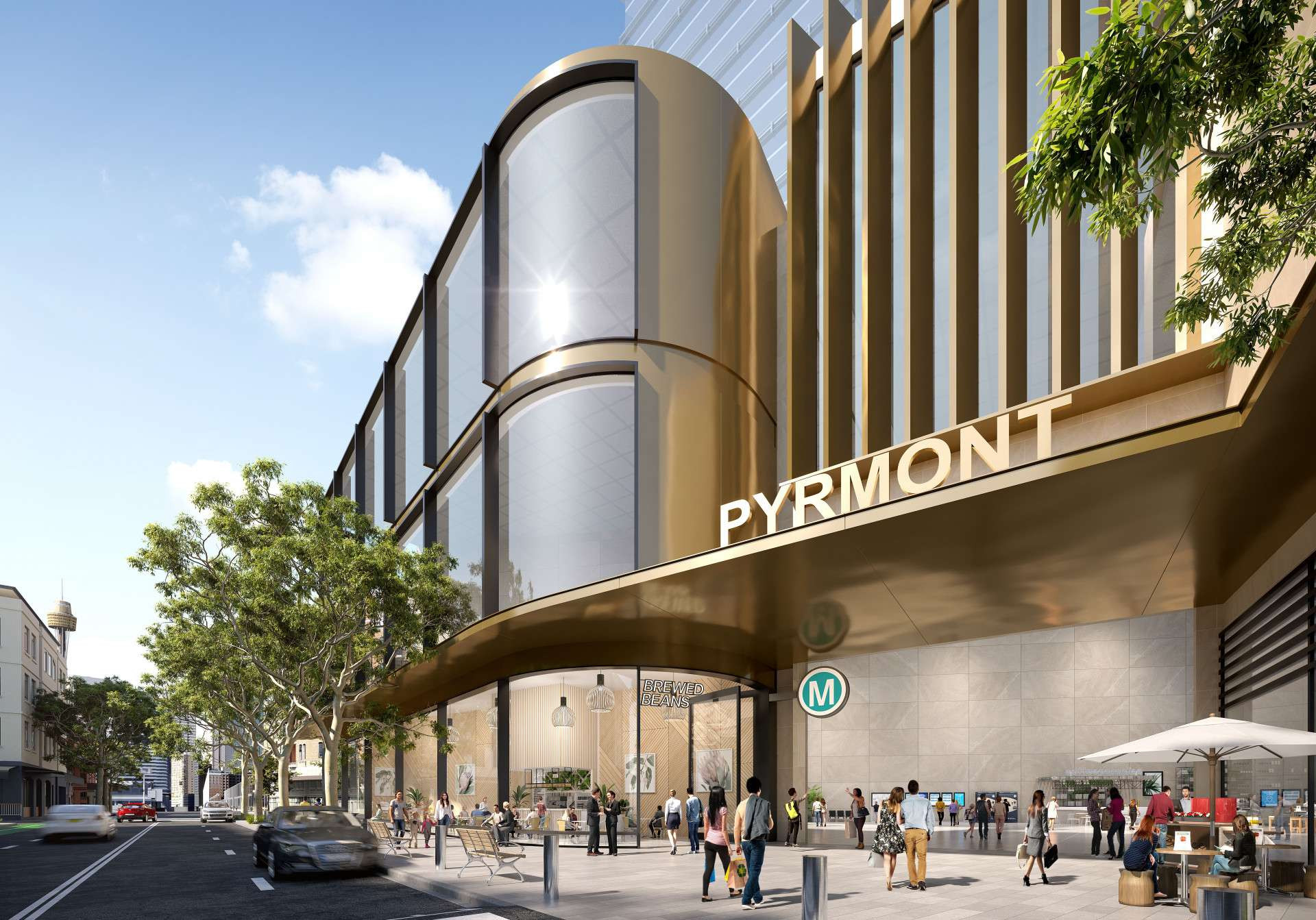
Pyrmont Station
Pyrmont Station will be a revitalised harbour-side precinct, enabled by the new metro station.
Over station development is being considered within the metro station precinct and will be subject to a separate planning approval including community and stakeholder engagement.
Rail infrastructure
Just like the Metro North West Line, Sydney Metro West will use advanced world-class signalling technology to support safe operations and control the way trains accelerate and brake at stations.
The signalling and train control system, operating from the Clyde stabling and maintenance facility, will automate the metro trains, including train spacing and speed monitoring.
Communications equipment will be within the designated services area at each station and also within the tunnels and at the Clyde stabling and maintenance facility.
Access shafts will be constructed for tunnel fit-out and rail systems work at Parramatta metro station, Burwood North Station, The Bays Station and Clyde stabling and maintenance facility.
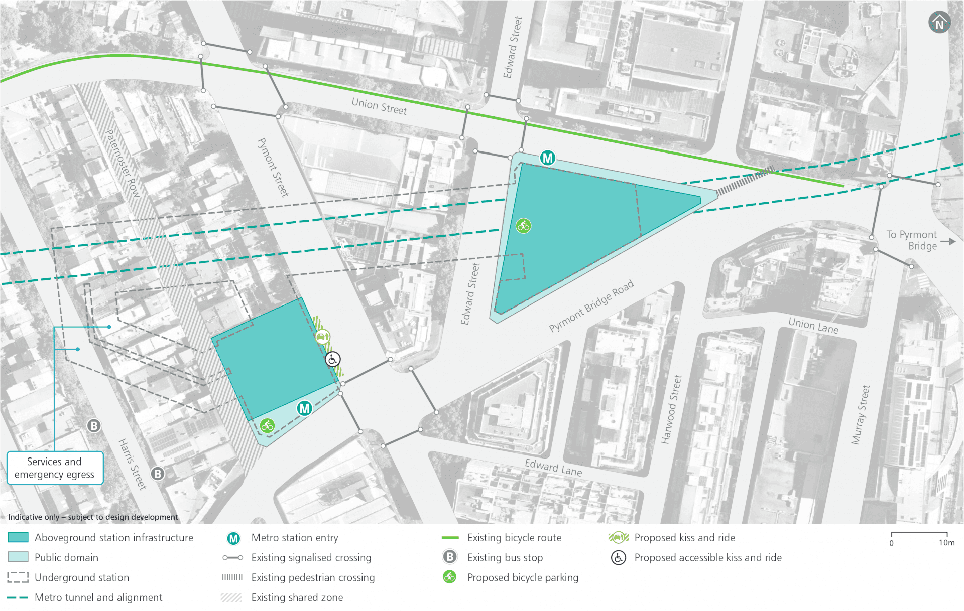
Operational precinct plan
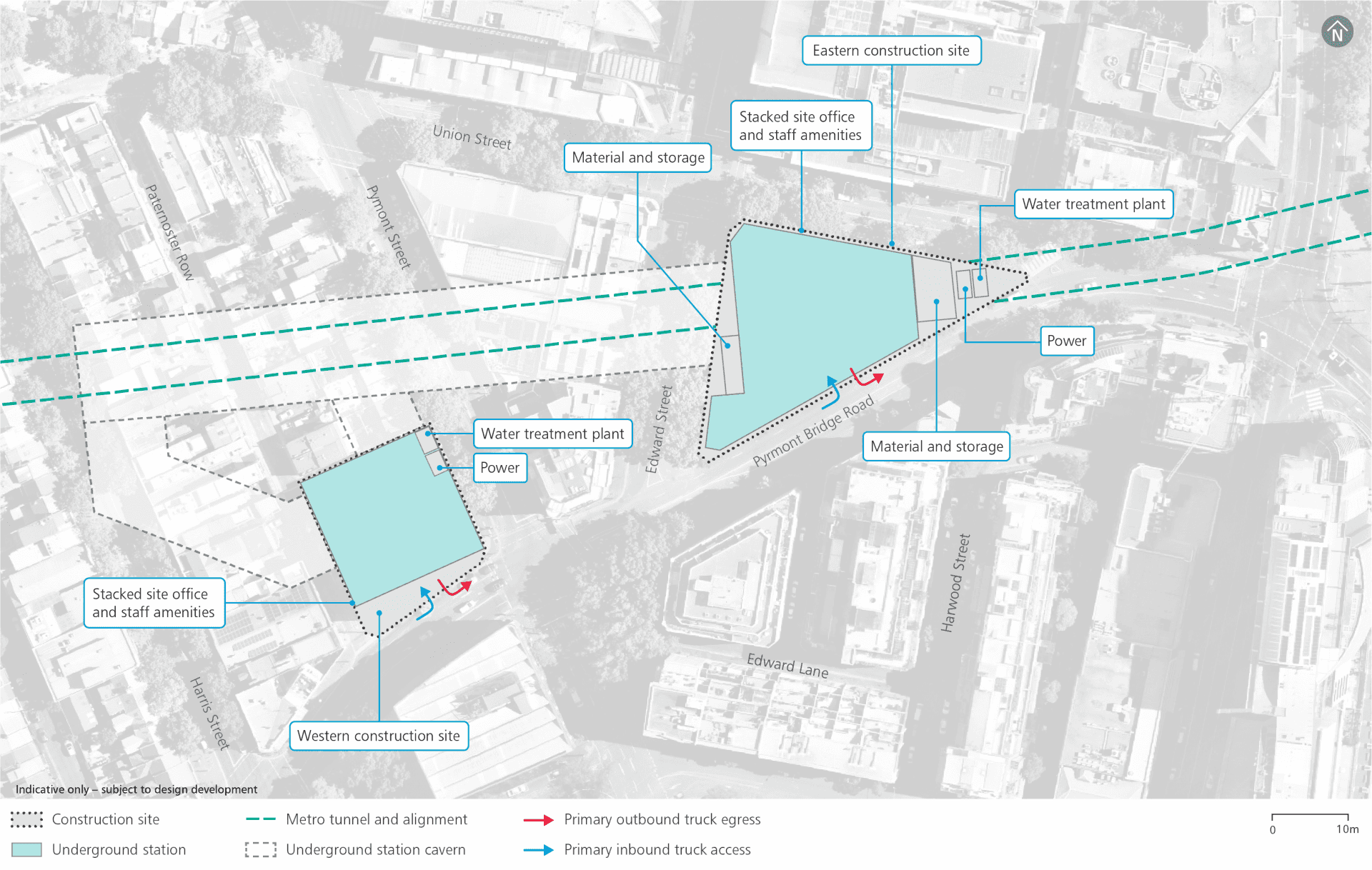
Construction footprint
Haulage routes
Continued site access arrangements are consistent with previous civil construction work:
- Pyrmont Bridge Road: left-in, left out
Additional site access arrangements include:
- Union Street: left-in, left-out.
Parking changes
Continued parking changes involving temporary removal of around 27 on-street car-parking spaces along Union Street between Edward Street and Pyrmont Bridge Road and a loading zone on Union Street between Pyrmont Street and Pyrmont Bridge Road.
Additional permanent parking changes to facilitate access and transport interchange include:
- two on-street spaces on Pyrmont Street (close to Pyrmont Bridge Road) to accommodate the proposed accessible kiss and ride space
- one on-street space on Union Street fronting the proposed eastern station entry to provide additional pedestrian space near the station entry
- four on-street spaces on Edward Street to accommodate proposed vehicular accesses.
Pedestrian and cycling changes
Continued temporary traffic changes include:
- Closure of the southern footpath on Union Street between Edward Street and Pyrmont Bridge Road.
Public transport changes
No additional public transport changes.
The previous planning approval identified decommissioning of the bus stop on Pyrmont Bridge Road, adjacent to the Pyrmont Station western construction site.
Nearby projects
Sydney Metro is committed to working closely with other nearby projects, local councils, NSW Government agencies and stakeholders to manage and coordinate construction activities and traffic, to help minimise impacts on the community. Other projects near to Pyrmont Station include:
Placemaking
In the commercial heart of the Sydney CBD, the Hunter Street Station will become a new hub with easy connections to George Street, Light Rail, Sydney Trains services at Wynyard and Martin Place and the new Sydney Metro City & Southwest station at Martin Place. A large busy precinct between George, Hunter, O’Connell and Bligh streets will prioritise pedestrians and support a vibrant public domain in the heart of the Sydney CBD.
Station entrances are proposed to be located on George, O’Connell and Bligh streets. Proposed underground walkways will allow for easy transit all the way from Martin Place to Barangaroo, providing efficient links with Sydney Metro City & Southwest and Sydney Trains services.
The new station is expected to have the busiest city-bound platform across the entire Sydney rail network in the AM peak, taking pressure off Wynyard and Town Hall stations.
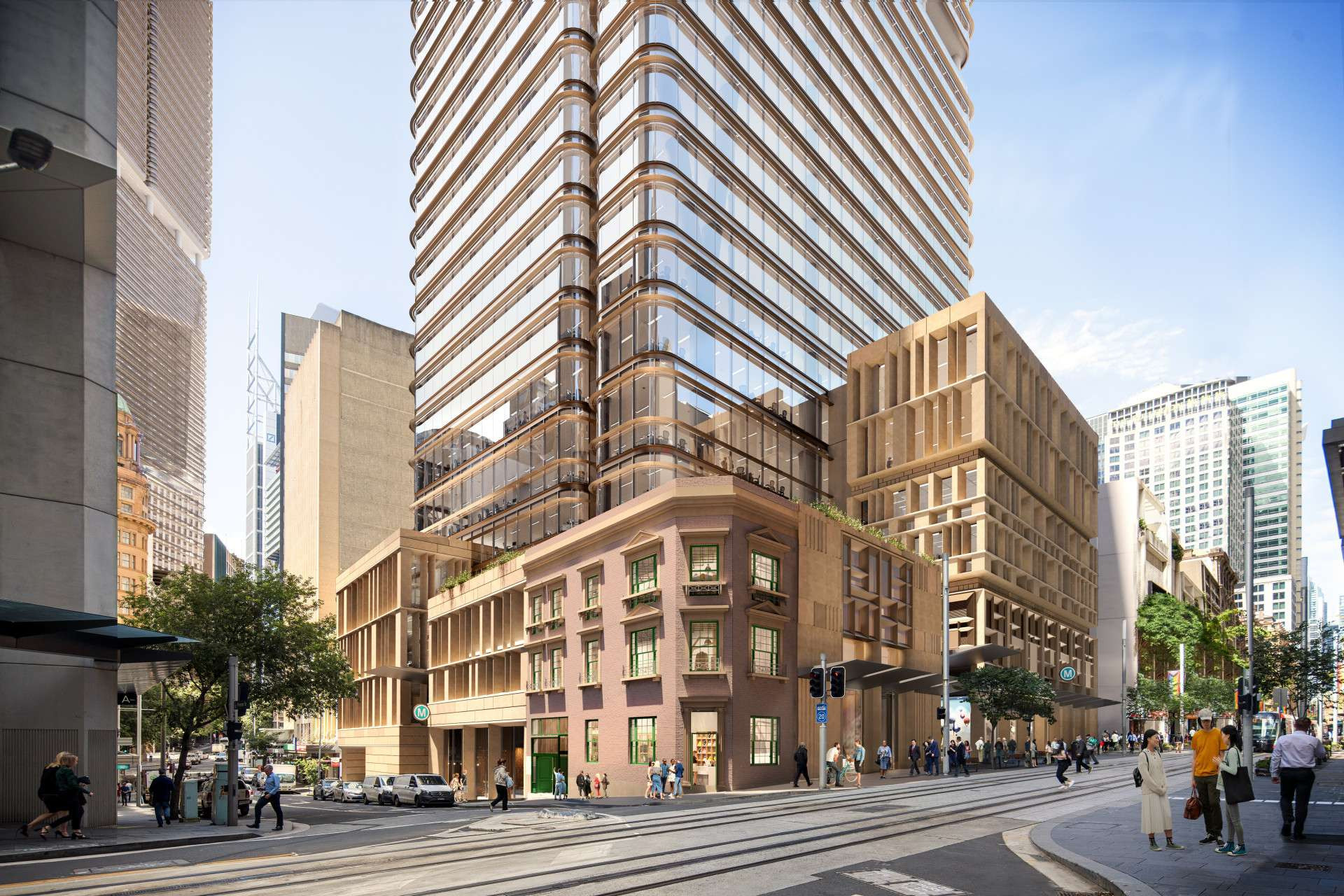
Hunter Street Station
Hunter Street Station will be a landmark station in the commercial heart of the Sydney CBD, unlocking connections and economic opportunities with Greater Parramatta.
Over station development is being considered within the metro station precinct and will be subject to a separate planning approval including community and stakeholder engagement.
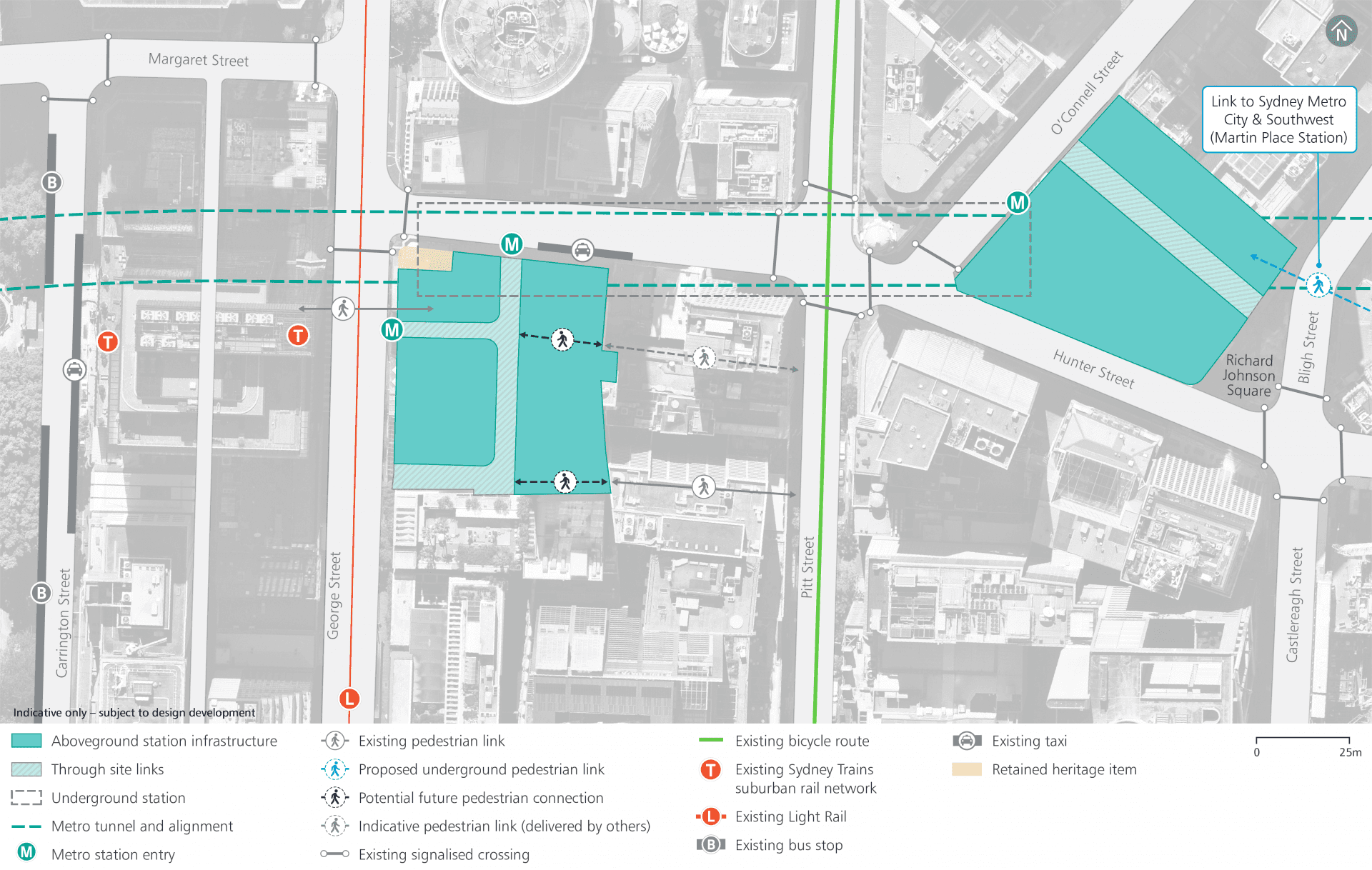
Operational precinct plan
Rail infrastructure
Just like the Metro North West Line, Sydney Metro West will use advanced world-class signalling technology to support safe operations and control the way trains accelerate and brake at stations.
The signalling and train control system, operating from the Clyde stabling and maintenance facility, will automate the metro trains, including train spacing and speed monitoring.
Communications equipment will be within the designated services area at each station and also within the tunnels and at the Clyde stabling and maintenance facility.
Access shafts will be constructed for tunnel fit-out and rail systems work at Parramatta metro station, Burwood North Station, The Bays Station and Clyde stabling and maintenance facility.
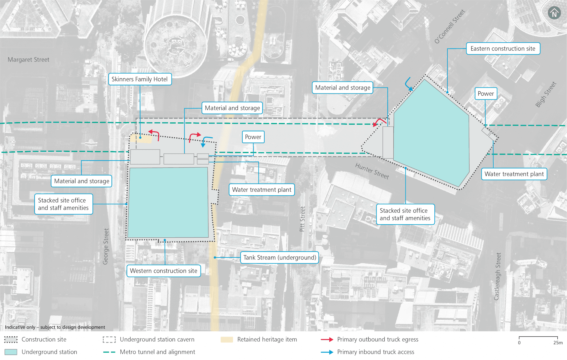
Construction footprint
Haulage routes
Continued site access arrangements consistent with previous civil construction work:
- Hunter Street: left-in, left-out, right-out
- O’Connell Street: left-in, left-out.
Nearby projects
Sydney Metro is committed to working closely with other nearby projects, local councils, NSW Government agencies and stakeholders to manage and coordinate construction activities and traffic, to help minimise impacts on the community. Other projects near to Hunter Street Station include:
Traffic changes
No additional traffic changes. The previous planning approval identified the need for full permanent closure of De Mestre Place.
Pedestrian and cycling changes
No additional changes are proposed to existing pedestrian and cyclist links.
The previous planning approval identified that the underground pedestrian route from Wynyard to the Hunter Connection in the CBD will also be closed during construction.
Pedestrians will be diverted to the surface, which will remain open. The underground route will re-open when Hunter Street Station opens, to facilitate transit between Martin Place and Barangaroo. The cycle route on Pitt Street will be unaffected by our works.
Parking changes
Continued parking changes including:
- Temporary removal of on-street parking spaces along Hunter Street adjacent to the western construction site
- Temporary removal of on-street parking spaces along O’Connell Street adjacent to the eastern construction site
- Temporary extension of a morning peak clearway on the northern side of Hunter Street between Pitt Street and Bligh Street (in addition to the existing evening peak clearway).

Parramatta metro station
Parramatta metro station will be an employment, residential and cultural precinct in the heart of Parramatta’s CBD.
Over and adjacent station development is proposed within the metro station precinct and is subject to a separate planning approval including community and stakeholder engagement.
Rail infrastructure
Just like the Metro North West Line, Sydney Metro West will use advanced world-class signalling technology to support safe operations and control the way trains accelerate and brake at stations.
The signalling and train control system, operating from the Clyde stabling and maintenance facility, will automate the metro trains, including train spacing and speed monitoring.
Communications equipment will be within the designated services area at each station and also within the tunnels and at the Clyde stabling and maintenance facility.
Access shafts will be constructed for tunnel fit-out and rail systems work at Parramatta metro station, Burwood North Station, The Bays Station and Clyde stabling and maintenance facility.
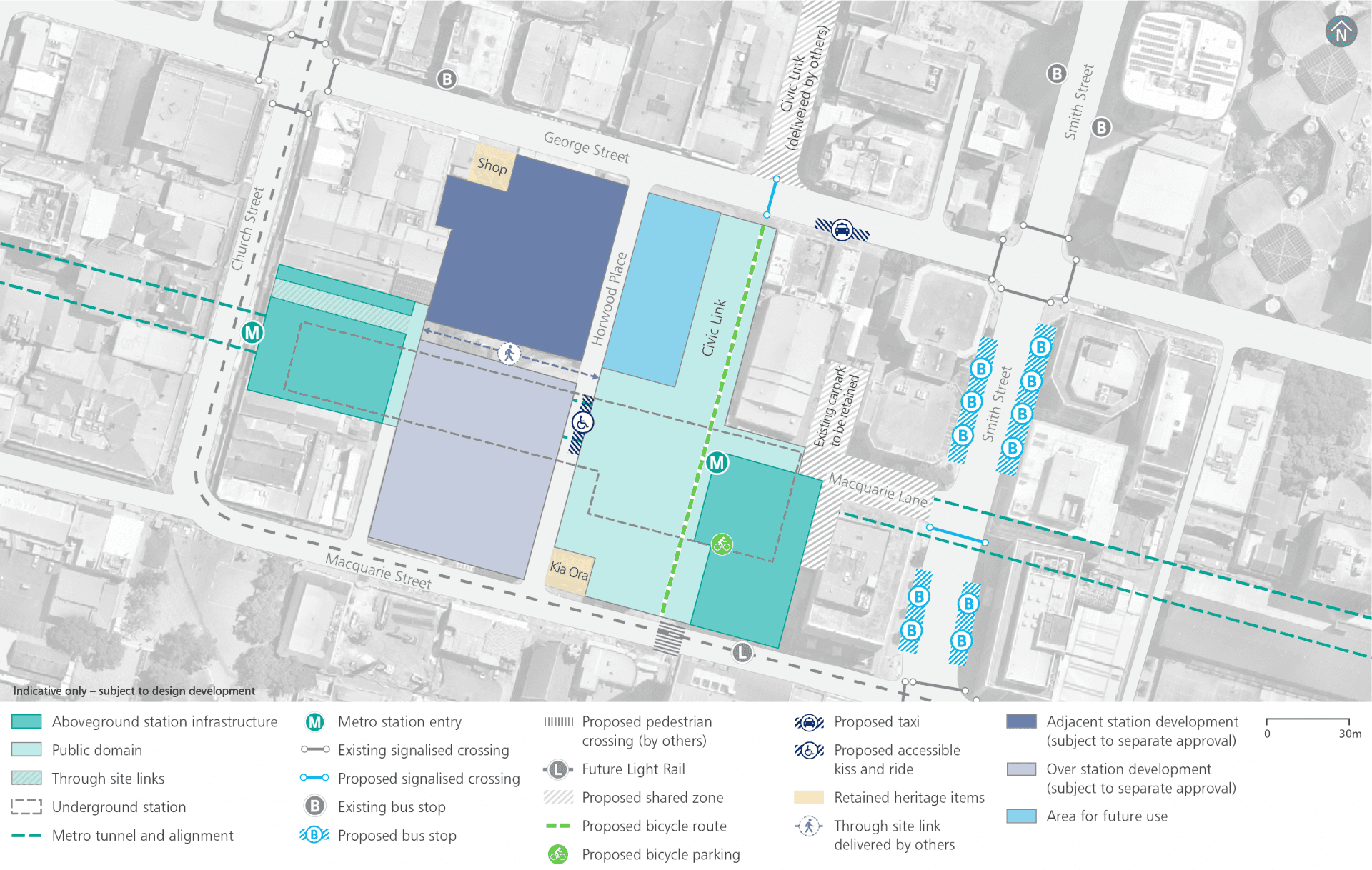
Operational precinct plan
Heritage
Management and mitigation measures will be used where impacts to heritage items have been identified.
This may include conservation and re-use of heritage fabric, and archiving and recording the item for future generations.
Any potential archaeological investigations will be undertaken as required in accordance with Heritage Council guidelines. Any potential Aboriginal archaeological remains found will be interpreted by an Aboriginal heritage specialist in consultation with registered Aboriginal parties.
Aboriginal and non-Aboriginal archaeological remains are not expected in this location.
Noise mitigation
Across the project alignment, predicted operational noise levels are expected to be generally compliant with the applicable noise criteria set out in the relevant guidelines. Where required, mitigation measures will be included as part of the project design to ensure full compliance.
Potential overall noise impacts during construction are expected to be similar to those assessed in the Environmental Impact Statements for ‘Major civil construction work between Westmead and The Bays’ and ‘Major civil construction between The Bays and Sydney CBD’. We know that temporary noise impacts affect people differently and, depending on the location of new activities, some people may notice more noise and some people may notice less.
The Sydney Metro West team will consider alternative construction methods to help mitigate noise where possible and will work with the community to provide scheduled respite periods during which high noise or vibration activities are not undertaken.
Noise mitigation - Western site
Sydney Metro branded hoarding will be erected around the perimeter of the western construction site at Hunter Street Station to mitigate potential temporary noise impacts.
Potential construction noise and vibration impacts will be managed in accordance with the Sydney Metro Construction Noise and Vibration Standard which aims to manage noise and vibration levels through feasible and reasonable measures. The Standard provides a process for the development of site or activity specific Construction Noise and Vibration Impact Statements, standard mitigation measures and additional mitigation measures to be implemented based on noise and vibration levels.
The Sydney Metro West team will consider alternative construction methods to help mitigate noise where possible and will work with the community to provide scheduled respite periods during which high noise or vibration activities are not undertaken.
Noise Mitigation
Across the project alignment, predicted operational noise levels are expected to be generally compliant with the applicable noise criteria set out in the relevant guidelines. Where required, mitigation measures will be included as part of the project design to ensure full compliance.
Potential overall noise impacts during construction are expected to be similar to those assessed in the Environmental Impact Statements for ‘Major civil construction work between Westmead and The Bays’ and‘Major civil construction between The Bays and SydneyCBD’. We know that temporary noise impacts affect people differently and, depending on the location of new activities, some people may notice more noise and some people may notice less
The Sydney Metro West team will consider alternative construction methods to help mitigate noise where possible and will work with the community to provide scheduled respite periods during which high noise or vibration activities are not undertaken.