Environmental Impact Statement Chapter 18.0 Woden precinct
Table of contents
Accessibility
This digital version of the EIS is designed to be accessible to all users, providing screen reader compatibility, keyboard navigation, and described images. If you require additional assistance or have specific accessibility needs, please contact us at lightrailtowoden@act.gov.au or call 1800 956 409.
18.0 Woden precinct
This chapter provides an assessment of potential impacts during operation and construction that relate to the Woden precinct, and identifies mitigation measures to address these impacts. Environmental issues assessed in this chapter include:
- Traffic and transport (Section 18.1.2)
- Noise and vibration (Section 18.3)
- Biodiversity (Section 18.4)
- Historic heritage (Section 18.5)
- Landscape character and visual amenity (Section 18.6)
- Socioeconomic impacts (Section 18.7).
The assessment of some aspects of traffic and transport, biodiversity, historic heritage, and socioeconomic impacts are applicable to the Project as a whole. These aspects have also been assessed in Chapter 11 (Project-wide issues).
Some additional environmental issues relevant to this precinct have been considered at a Project-wide level only in Chapter 11 (Project-wide issues), as the potential impacts and management approach associated with the issue are applicable to the Project as a whole.
18.1 Overview
The Woden precinct extends from south of the Yarra Glen roundabout to around Neptune Street near the Woden town centre. The town centre has, and continues to expand rapidly, with new high-rise residential buildings, planned redevelopment of the Hellenic Club, and the new Canberra Institute of Technology (CIT) Campus in Woden set to open soon.
The Project within this precinct would be consistent for both alignment options.
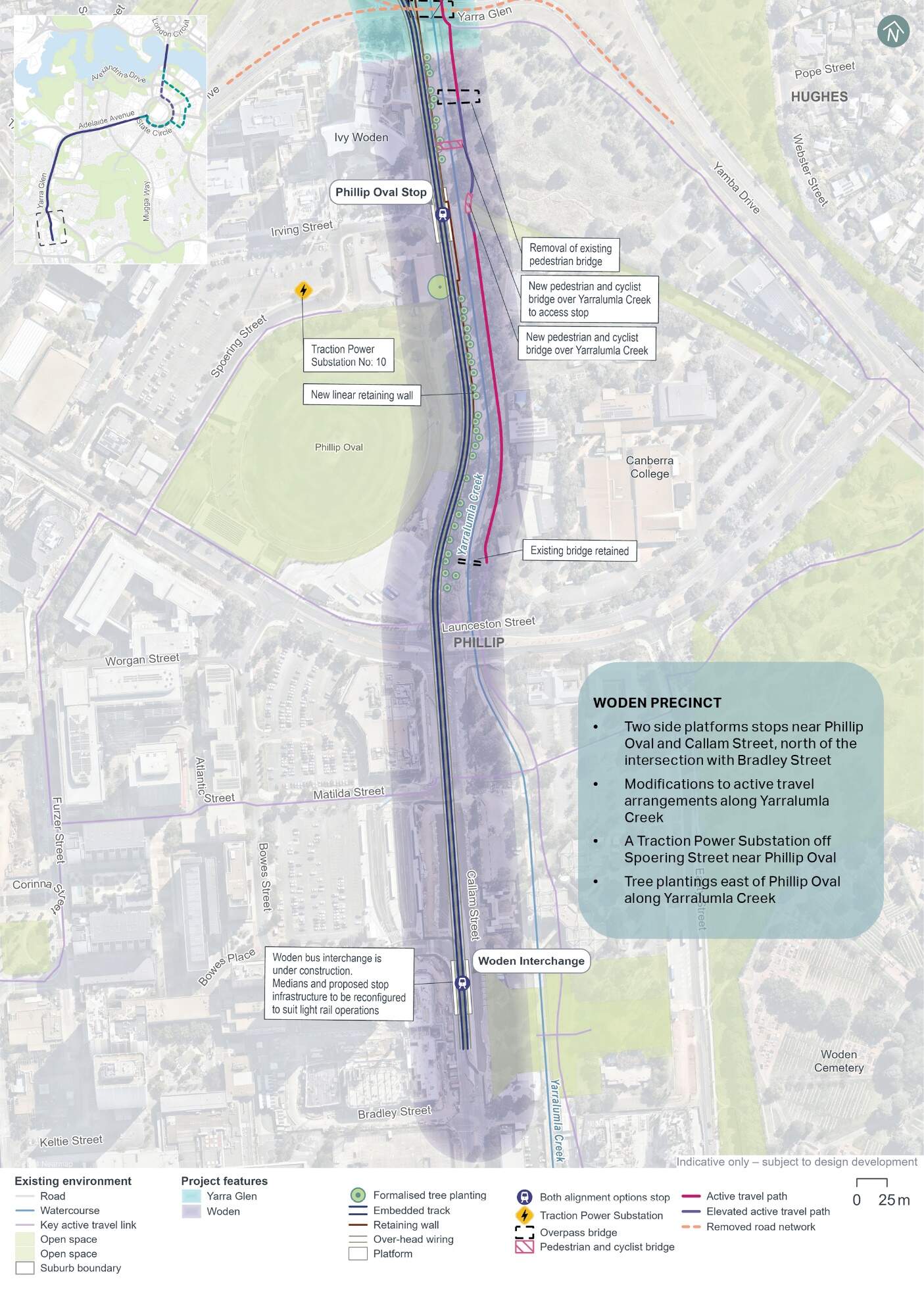
From the southern extent of the Yarra Glen roundabout, the light rail alignment would continue south along the western side of Yarralumla Creek, across Launceston Street, along Callam Street, terminating north of Bradley Street. The light rail would be within the road median (median running), with the exception of the light rail alignment between the Yarra Glen/Melrose Drive/Yamba Drive intersection and Launceston Street which would be outside of the road reserve.
The precinct would include two stops, the Phillip Oval Stop near Irving Street immediately north of Phillip Oval, and the Woden Interchange located on Callam Street between Bowes Street and Bradley Street.
The existing active travel arrangements (shared path) on the western side of Yarralumla Creek would be consolidated onto the eastern side of the creek. A section of this new active travel path would be on an elevated structure to respond to existing flood characteristics of the area, extending north and south around the Phillip Oval Stop.
The existing pedestrian bridge across Yarralumla Creek north of Phillip Oval would be removed.
Within the Woden precinct, the light rail would include over-head wiring.
The precinct would also include a traction power substation (TPS 10) in an existing carpark off Spoering Street near Phillip Oval.
Key Project features within the Woden precinct are shown in Figure 18-1. Refer to Chapter 5 (Project description) for a more detailed description of the Project within this precinct.
18.1.1 Key construction activities
Construction activities required within this precinct would be otherwise generally similar to those required across other precincts. Construction activities are considered at a Project-wide level within Chapter 6 (Construction).
Key construction activities within the Woden precinct would include:
- Construction of turnback facilities south of the Woden Interchange, such as installation of track and kerbs
- Construction of an elevated structure to provide for an active travel path, extending north and south around the Phillip Oval Stop area, including installation of piers and abutments (as described in Section 6.3.7)
- Construction of the TPS off Spoering Street near Phillip Oval (as described in Section 6.3.8).
Compound H (Easty Street car park in Woden) would be located within the Woden precinct. The location of the compound is shown in Figure 6-3 in Chapter 6 (Construction).
18.1.2 Environmental impact overview - construction
Key impacts within the Woden precinct from the construction of the Project are summarised below, and assessed in further detail throughout this precinct-based assessment chapter.
Traffic and transport
The construction of the Project within the Woden precinct would occur within and adjacent to the road reserve, leading to the temporary loss of up to 44 on-street kerbside parking spaces, around 380 off-street car parking spaces, and 11 off-street motorcycle spaces. Broader road network impacts are assessed in Chapter 11 (Project-wide issues). Construction activities are likely to be staged, so the temporary loss of on-street kerbside spaces may be less at any given time during the construction program.
Activity- and site-specific traffic management measures would be developed and implemented through the Construction Environmental Management Plan(s) for the Project. These measures would focus on managing construction-related traffic, site access, parking availability, and ensuring the adequate performance of the road network in proximity to construction site accesses and haulage routes. However, construction is expected to result in residual traffic impacts even after these measures are implemented. Construction planning would continue with the aim of minimising disruption to the road and transport networks.
Noise and vibration
Construction activities, including earthworks, road works, the decommissioning of utilities, construction of stops, and the establishment of construction compounds, are expected to generate noise that could moderately to highly affect nearby residential and non-residential buildings during the day and night, particularly during 'peak' construction scenarios (which represent the noisiest works that require the use of noise intensive equipment such as concrete saws and rock breakers).
In the night-time hours, residential receivers located adjacent to the proposed haulage routes on parts of Easty Street may be affected by the increases in road traffic noise levels (in instances where night works are required). Some residential buildings may also experience night time noise exceeding the sleep awakening reaction level.
Mitigation measures that would be implemented to manage these impacts, such as scheduling to minimise high-noise activities outside of standard construction hours, are expected to reduce the identified potential impacts. Works outside of standard hours would also require assessment and approval on a case-by-case basis. Despite these measures, some temporary disturbances are anticipated, but they are expected to be minimised through construction planning and community consultation.
Biodiversity
The Project design has been developed with the aim of avoiding direct and indirect impacts to Matters of National Environmental Significance (MNES) and other biodiversity values in the landscape by minimising the construction footprint. Despite this, some clearing of native vegetation and habitat for species protected under the Environment Protection and Biodiversity Conservation Act 1999 (Cth) (EPBC Act) and the Nature Conservation Act 1992 (ACT) (NC Act) would be required to construct and operate the Project. This would include a total of 1.23 hectares of vegetation within the Woden precinct, 0.65 hectares of which is characterised as native. Removal of this vegetation would impact upon suitable habitat for the Golden Sun Moth (Synemon plana) (listed as vulnerable under the EPBC Act and NC Act), foraging habitat for the Gang-gang Cockatoo (Callocephalon fimbriatum) (endangered under the EPBC Act and NC Act) and Superb Parrot (Polyletis swainsonii) (vulnerable under the EPBC Act and NC Act), and breeding and foraging habitat for the Diamond Firetail (Stagonopleura guttata) (vulnerable under the EPBC Act and NC Act). A total of 31 mature native trees, which provide suitable breeding and/or foraging habitat for woodland birds, have also been in the proposed clearance footprint for the Woden precinct.
Opportunities to further avoid or minimise biodiversity impacts, and to enhance habitat and connectivity through Project landscaping would be considered through ongoing design development. A Biodiversity Offset Strategy has been developed for the Project to manage residual impacts which are unable to be avoided, and would be updated to reflect any further avoidance or minimisation of biodiversity impacts achieved through ongoing design development.
Other impacts
Other potential construction environmental impacts identified in this precinct-based assessment chapter are outlined below:
- Historic heritage: The Callam Offices, listed on the ACT Heritage Register, has been identified within the Woden Precinct. While direct impacts have been avoided, the Callam offices have the potential to be indirectly affected by the Project during construction through vibration caused by construction activities, and by temporary visual impacts due to temporary infrastructure proposed for the carpark to the north. However, these impacts would be avoided through appropriate equipment selection, and determination and monitoring of safe vibration levels
- Landscape character and visual amenity: Construction activities such as the establishment of construction compounds and the use of large-scale equipment, would be visually prominent and may temporarily disrupt the visual amenity of the area. Night-time construction work would involve lighting that could impact nearby residential and commercial properties. Mitigation measures, such as high-quality construction hoarding, efforts to minimise light spill and preparation of a visual impact (including light spill) management plan, would be implemented to manage these impacts and maintain the area's visual integrity
- Socioeconomic: Potential impacts would include disruptions to local amenity, road network and parking as well as adverse impacts to health and wellbeing due to noise, vibration, and visual impacts, which may particularly affect workers, residents and visitors in the area. Mitigation measures, such as the implementation of Construction Environmental Management Plan(s), proactive communication strategies, and public awareness campaigns, would be implemented to minimise these impacts.
Environmental management and mitigation measures proposed to address the specific impacts of the Project within this precinct are detailed in Chapter 21 (Environmental management and mitigation measures).
For construction related impacts, a Construction Environmental Management Plan(s) (CEMP) would be prepared as a framework for environmental management, including several sub plans (such as a noise and vibration and traffic and transport management plans) and mitigation measures. An Environmental Management Plan outline (addressing construction and operational aspects) has been developed for the Project to guide the development of the CEMP(s) and sub plans, and is included as Appendix L (Environmental Management Plan outline).
18.1.3 Environmental impact overview - operation
Key impacts within the Woden precinct during the operational stage of Project are summarised below, and assessed in further detail throughout this precinct-based assessment chapter.
Traffic and transport
The operational phase of the Project in the Woden precinct would require changes to the road network, including road closures and adjustments to existing lanes, intersections and access arrangements to accommodate the light rail infrastructure.
Within the Woden precinct, there would be localised areas where higher congestion levels would occur in both the with and without Project scenarios (for both alignment options) in the AM and PM peak hours in both 2031 and 2041.
No kerbside parking spaces would be lost as a part of the Project, however public access to the Phillip Oval car park via Irving Street would be permanently removed, with the existing car park of around 50 spaces being made unavailable to the public. Additionally, 33 car parking spaces and six motorcycle parking spaces would be removed from the Spoering Street car park.
Further design development and management measures would be implemented to address these changes, such as public awareness campaigns to increase understanding of new arrangements and interactions between cars, bicycles and pedestrians with light rail during operation, and review of options to further optimise the interface between different transport modes. Other operational impacts have been assessed at a Project-wide basis, where relevant, in Section 11.2.2 of Chapter 11 (Project-wide issues).
Other impacts
Other operational environmental impacts identified in this precinct-based assessment chapter are outlined below:
- Landscape character and visual amenity: The introduction of light rail infrastructure, including tracks, stops, and over-head wiring, would result in permanent changes to the landscape character and visual amenity of the area. A moderate to low overall impact is predicted in the Woden precinct for both alignment options. The Public Domain Master Plan (Appendix I) identifies design principles and guidance for the Project. As identified in mitigation measure LV1 in Chapter 21 (Environmental management and mitigation measures), these principles would be applied to the Project through ongoing design development and would contribute to management and mitigation of landscape and visual impacts of the Project during operation
- Biodiversity: In addition to direct biodiversity impacts associated with clearing of native vegetation and habitat of protected species (as described in Section 18.1.2), native vegetation and habitat adjacent to the clearance footprint, and species using air space above the Project have the potential to experience indirect impacts from the operation of the Project. This could include noise and vibration impacts from light rail operations, increased light pollution on sensitive habitats and species around light rail stops, or potential risk of fauna strike from light rail vehicles (LRVs) or over-head wiring. Proposed mitigation measures include strategies to minimise fauna strike through effective landscape design
- Noise and vibration: Operation of the Project would result in limited noise and vibration impacts within the precinct, with noise and vibration levels predicted to comply with relevant criteria at the majority of receivers. Some minor exceedances of criteria for airborne noise are predicted at receivers closest to the alignment (Canberra College and CIT Woden), assuming no mitigation measures are in place. The Project would be designed and operated to minimise operational noise and vibration impacts on sensitive receivers, predominantly through consideration of track design measures, and operational maintenance planning. These measures that would enable residual impacts to be limited
- Socioeconomic: Benefits of the Project within the Woden precinct include provision of an alternative to private vehicle use, which can enhance accessibility and over time, reduce potential traffic congestion. Adverse socioeconomic impacts may also arise, for example, at Canberra College and CIT Woden, where operational noise of light rail infrastructure could potentially affect social amenity. Continued implementation of design principles and guidance documented in the Public Domain Master Plan would support design of a high quality and manage these potential impacts
- Historic heritage: No impact to the Callam Offices (listed on the ACT Heritage Register) would occur during operation of the Project.
Environmental management and mitigation measures proposed to address the specific impacts of the Project within this precinct are detailed in Chapter 21 (Environmental management and mitigation measures). An Operational Environmental Management Plan (OEMP) with supporting sub plans would be implemented as a framework for environmental management during operation. An Environmental Management Plan outline has been developed for the Project to guide the development of the OEMP, and is included as Appendix L (Environmental Management Plan outline).
18.2 Traffic and transport
This section provides an assessment of the potential multimodal traffic and transport impacts associated with the construction and operation of the Project within the Woden precinct. Further detail on the traffic and transport impact assessment is provided in Technical Report 1 - Traffic and transport. The methodology applied for this assessment is summarised in Chapter 10 (Assessment methodologies) and discussed in detail in Section 3 of Technical Report 1 - Traffic and transport. Impacts to traffic and transport for the Project as a whole are discussed in Section 11.1 of Chapter 11 (Project-wide issues).
18.2.1 Existing environment
This section provides an overview of the existing traffic and transport features within the Project area. To understand the existing environment relevant to traffic and transport, the following have been considered: the transport network, road network, traffic volumes, intersection performance, public and active transport, carparking (including kerbside uses and access), and crash history.
Transport network
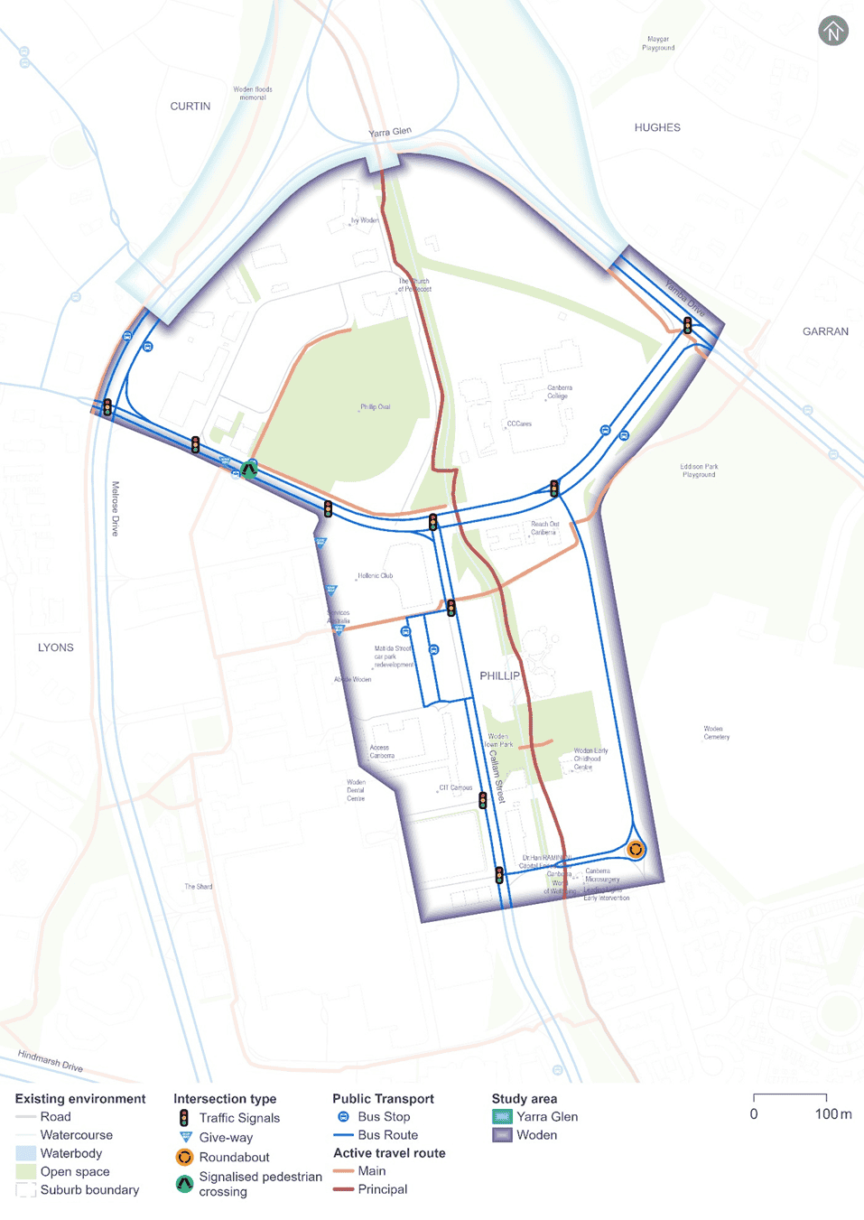
The study area for this assessment is based on the Project area with an additional buffer to incorporate the surrounding road network (the precinct study area). The existing transport network within the Woden precinct and the respective study area is indicatively shown in Figure 18-2.
Road network
The characteristics of key roads within the Woden precinct are summarised in Table 18-1.
| Road | Classification | Direction | Configuration | Speed limit1 |
|---|---|---|---|---|
|
Melrose Drive |
Arterial |
Two-way |
Two northbound lanes and three southbound lanes |
60 km/h |
|
Yamba Drive |
Two lanes in each direction |
80 km/h |
||
|
Launceston Street |
Major collector |
Two-way |
Two lanes in each direction |
60 km/h |
|
Callam Street |
Currently no access as it is under construction and will to be restricted to buses only between Matilda Street and Bradley Street upon completion of the Woden Interchange project |
60 km/h |
||
|
Irving Street |
Local access |
Two-way |
One lane in each direction |
50 km/h |
|
Matilda Street |
One lane in each direction |
50 km/h |
||
|
Bowes Street |
One lane in each direction |
40 km/h |
Notes:
- Where no speed limit was signposted, the speed limit was assumed to be 50 km/h, which is the default speed limit for a built-up area.
Traffic volumes
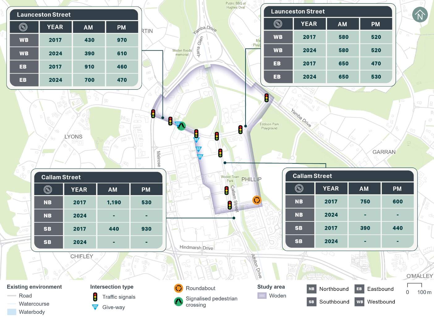
Existing 2024 and historical 2017 weekday AM (8:00am to 9:00am) and PM (5:00pm to 6:00pm) peak hour traffic counts for various mid-block locations within the Woden precinct have been analysed and are summarised in Figure 18-3. The 2024 data along Launceston Street indicates a reduction in traffic during the AM and PM peak hours since 2017. No 2024 data is available for the locations along Callam Street, given the ongoing construction works in the area associated with CIT Woden and the new bus interchange.
Intersection performance
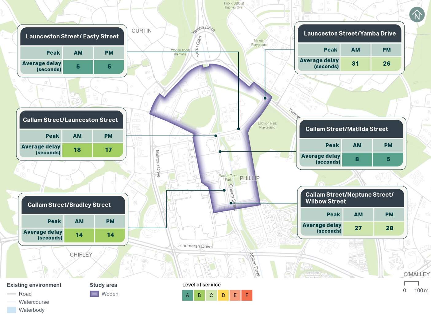
The existing operation of the key intersections within the Woden precinct has been assessed using the microsimulation model, as discussed in Chapter 10 (Assessment methodologies). The existing performance of the assessed intersections is shown in Figure 18-4.
All the assessed intersections within the Woden precinct operated satisfactorily in 2017 at a level of service C or better during the weekday peak hours. Level of service represents the extent of delays experienced by drivers at an intersection.
Public transport
The Woden bus interchange is located within the Woden Town Centre and services local and rapid services.
The interchange is currently being reconfigured, as discussed in Section 3.5.3 Technical Report 1 - Traffic and transport, to increase capacity and allow for future integration with light rail services being delivered as part of this Project. The current temporary configuration involves six platforms adjacent to Callam Street between Bowes Street and Matilda Street. The new interchange is located immediately to the east of the temporary interchange and once constructed, will include eight platforms servicing busses along Callam Street between Bradley Street and Matilda Street, as well as allowance for light rail services through the centre of the interchange.
Transport Canberra operates bus routes servicing this precinct and provides services to the city centre, Weston Creek and Tuggeranong. The Woden precinct contains the Woden Interchange, meaning a higher number of bus routes operate within this precinct when compared to others. The bus routes that operate within the Woden precinct are: R4, R5, R6, 57, 58, 59, 60/61, 62, 63, 64, 65, 66, 70, 71, 72, 73, 76, 77, and 902.
In addition to the local and rapid bus services multiple school routes use the Woden Interchange. On school days, these school bus services typically have one service each in the morning and afternoon.
A bus layover is located on the northern side of Launceston Street, accommodating 24 buses. Access is provided via the Launceston Street/Bowes Street intersection and/or the Launceston Street/Callam Street intersection.
Active travel
The C4 City to Tuggeranong via Woden principal cycle route runs along Yarralumla Creek through the Woden precinct, generally from the Yarra Glen/Melrose Drive/Yamba Drive intersection towards Hindmarsh Drive to the south. East-west on-road cycle lanes are provided on both sides of Launceston Street. A two-way off-road cycle path is provided on Matilda Street between Bowes Street and Callam Street. Signalised pedestrian crossings are provided at the following intersections:
- Launceston Street/Easty Street on all approaches
- Launceston Street/Callam Street on all approaches
- Launceston Street/Bowes Street on all approaches
- Callam Street/Wilbow Street/Neptune Street on all approaches
- Callam Street/Corinna Street on all approaches.
Zebra crossings are provided at the north and south ends of the current temporary Woden bus interchange and on the slip lanes at surrounding intersections.
Due to the ongoing reconfiguration of Callam Street, pedestrian accessibility between Launceston Street and Wilbow Street/Neptune Street is currently impeded in various locations.
Plans for the new Woden Interchange indicate that the Callam Street/Matilda Street and Callam Street/Bradley Street intersections would be signalised. In addition, two signalised pedestrian crossings would be provided mid-block within the interchange on either end of the light rail platforms.
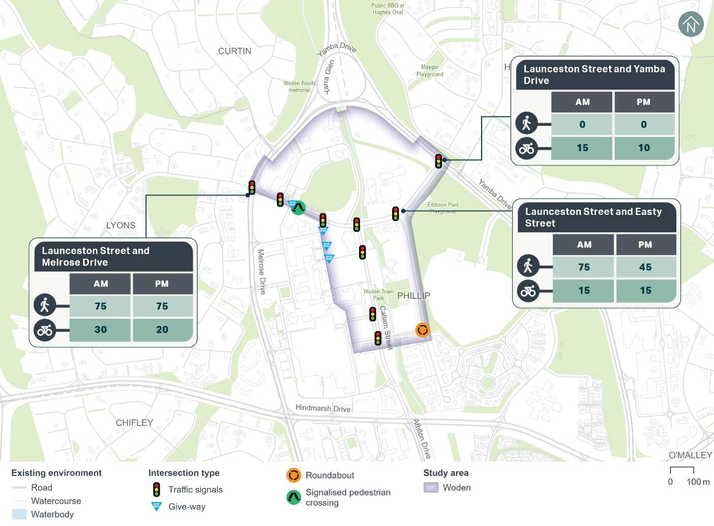
Pedestrian and cyclist count data from 2024 has been used to understand current active travel demand within the Woden precinct. The AM and PM peak hour counts at key locations within the precinct are summarised in Figure 18-5. As shown, pedestrian volumes along Launceston Street are higher near Easty Street and Melrose Drive due to the more densely populated land uses near these locations. Cyclist volumes ranged between 10 and 30 cyclists during the peak hours at the surveyed locations.
Car parking, kerbside uses and access
Kerbside uses
The existing kerbside uses including on-street parking within the Woden precinct are summarised in Table 18-2.
| On/off alignment | Road | Between | Side of road | Restriction | Number of existing spaces |
|---|---|---|---|---|---|
|
Off alignment |
Irving Street |
North of Launceston Street |
North |
2P (8:30 am - 5:30 pm Monday to Friday) |
8 |
|
No parking, pick-up and set-down only |
1 |
||||
|
Bus zone (public) |
N/A |
||||
|
P5min (7:30 am - 6:00 pm Monday to Friday) |
5 |
||||
|
South |
2P (8:30 am - 5:30 pm Monday to Friday) |
28 |
|||
|
Spoering Street |
Irving Street and Irving Street |
East |
2P (8:30 am - 5:30 pm Monday to Friday) |
26 |
|
|
West |
2P (8:30 am - 5:30 pm Monday to Friday) |
22 |
|||
|
Bowes Street |
Launceston Street and Callam Street |
East/north |
No parking, pick-up and set-down only |
3 |
|
|
1/4P (7:30am - 6:00 pm Monday to Friday) |
6 |
||||
|
West/south |
Loading zone (7:30am - 6:00 pm Monday to Friday) |
3 |
|||
|
No parking, pick-up and set-down only |
4 |
||||
|
Neptune Street |
Bradley Street and Callam Street |
South |
30 min loading zone (7:30 am - 6:00 pm Monday to Friday) |
2 |
|
|
P5min |
3 |
||||
|
Total |
111 |
||||
Off-street parking
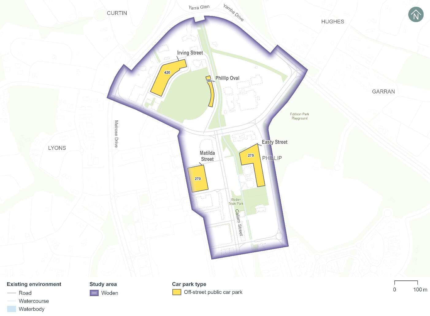
There are several existing off-street public car parks located within the Woden precinct including:
- Spoering Street car park: at-grade car park with around 420 spaces
- Phillip Oval car park: at-grade car park with around 50 spaces
- Matilda Street car park: at-grade car park with around 270 spaces
- Easty Street car park: at-grade car park with around 275 spaces.
These car parks accommodate around 1,015 car parking spaces, as shown in Figure 18-6. In addition, there are several other car parks throughout the town centre associated with Westfield Woden.
Based on parking counts from 2022, the Phillip Oval and Easty Street car parks experienced moderate demand, with around 40-50% of the car parking spaces occupied at the busiest time of the day. The Phillip Oval car parks also accommodate parking for events held at the oval, contributing to fluctuations in demand beyond typical daily usage. The Spoering Street and Matilda Street car parks all experienced high parking demand, with peak occupancy between 85% and 95%.
Site observations on 11 June 2024 confirmed that the Spoering Street car park is well utilised. However, it is estimated that around 30-40% of the vehicles parked are associated with nearby construction worker activity.
Property access
There are several property accesses located along the Project's alignment within the Woden precinct, summarised in Table 18-3.
| Road | Site address | Site access arrangement |
|---|---|---|
|
Irving Street |
Ivy Apartments |
Single access point on Irving Street |
|
Phillip Oval car park |
Single access point on Irving Street |
|
|
Launceston Street |
Bus layover area |
Vehicle egress via the northern leg of the Launceston Street/Callam Street |
Crash history
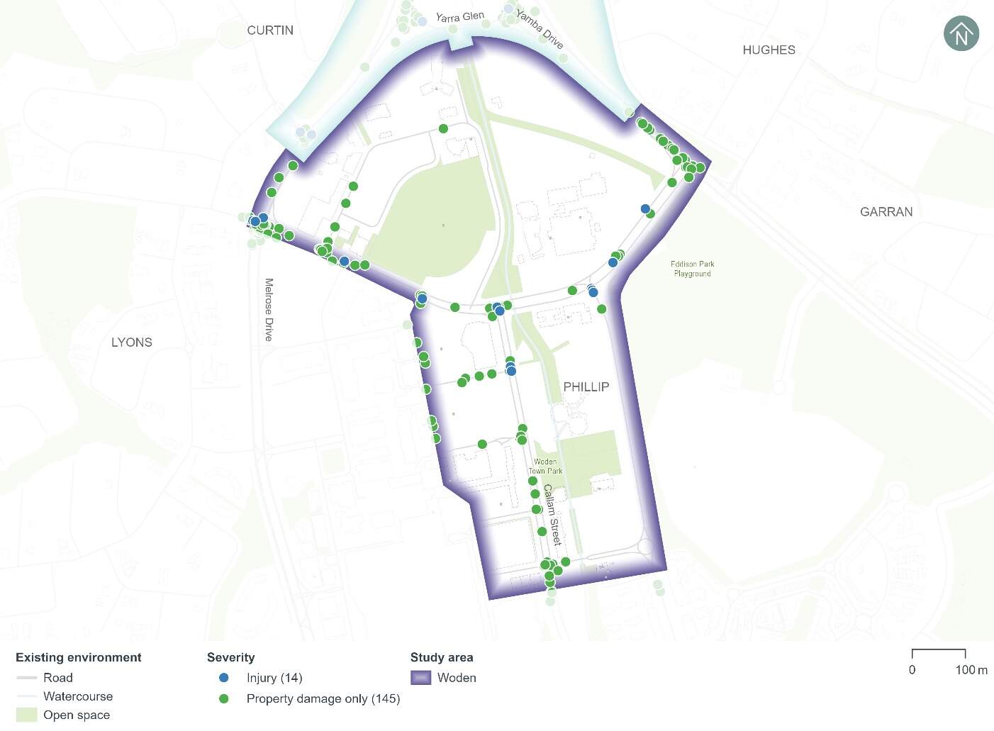
Figure 18-7 shows the five year crash history (1 January 2018 to 31 December 2022) within the Woden precinct.
A total of 159 crashes have been recorded within the Woden precinct during the five year period, including:
- Three crashes that resulted in a serious injury (around 2%)
- 11 crashes that resulted in a minor injury (around 7%)
- 145 crashes that resulted in property damage only (around 91%).
The following common crash types occurred:
- Around 32% of crashes involved a rear end collision
- Around 23% of crashes involved right angle collision
- Around 18% of crashes involved a same direction side swipe.
- Three of the crashes involved pedestrians.
Modelling approach
The transport modelling assumptions have adopted the 'committed and funded expenditure approach' as per Infrastructure Australia guidance. This approach was agreed in consultation with Treasury and other key stakeholders including TCCS. The 'committed and funded expenditure approach' requires that only transport projects identified as 'committed and funded' are to be included in the 2031 and 2041 with and without Project scenarios.
As identified in the ACT Infrastructure Plan update - Transport (ACT Government, 2024), project priorities identified beyond the current budget are indicative and may change in response to community preferences, shifts in demand for services and the availability of funding. This means that any projects that might be in planning or may be required to accommodate expected travel demands but have not been identified as 'committed and funded' are not included in the traffic modelling for the Project. This is particularly prevalent in the 2041 scenarios during Project operation.
Based on the transport modelling inputs and assumptions presented above, the transport modelling assesses the impacts of the Project in isolation. It does not consider the broader network benefits that may be realised by the implementation of planned (but not committed and funded) transport infrastructure projects.
By not considering other changes to the transport network, the transport modelling presents an absolute worst-case scenario in relation to the performance of the future road network.
18.2.2 Potential impacts - construction
Potential impacts of the construction of the Project on parking and access within the precinct are summarised in the following sections. Other construction-related impacts have been assessed at a Project-wide basis, where relevant, in Section 11.1.2 of Chapter 11 (Project-wide issues).
Kerbside uses
It is estimated that up to 44 on-street kerbside spaces would be temporarily lost within the Woden precinct, including:
- 21 spaces on Irving Street (off-alignment)
- 23 spaces on Spoering Street (off-alignment).
Construction works are likely to be staged, so the temporary loss of on-street kerbside spaces across the precinct may be less at any given time during the construction program.
Off-street parking
The Project's construction compounds and Project area within the Woden precinct would temporarily reduce off-street car parking by around 380 spaces and 11 motorcycle parking spaces at the following locations:
- Site compound H - Easty Street car park: loss of around 180 parking spaces
- Phillip Oval car park: loss of around 50 parking spaces
- Spoering Street car park: loss of around 150 parking spaces and 11 motorcycle parking spaces.
Local area access
The Project's construction would not change any local area access arrangements in the Woden precinct other than the traffic diversions along Launceston Street during the reconstruction of the Yarra Glen/Yamba Drive/Melrose Drive intersection, as discussed in Section 5.8.3 of Technical Report 1 - Traffic and transport.
Property access
The Project's construction would not change any property accesses within the Woden precinct.
18.2.3 Potential impacts - operation
Potential operational impacts on the road network, active travel and parking of relevance to the precinct are summarised in the following sections. Other operational impacts have been assessed at a Project-wide basis, where relevant, in Section 11.2.2 of Chapter 11 (Project-wide issues).
Road network changes
The road network changes within the Woden precinct to accommodate the Project would include road closures, adjustments to existing lanes, adjustments to intersections, and adjustments to access arrangements. Refer to Chapter 5 (Project description) for further discussion on road network changes.
Traffic volumes and patterns
Traffic volumes and patterns have been modelled to compare weekday peak hour changes in traffic flow across the Woden precinct, particularly on Melrose Drive, Yamba Drive, and Launceston Street.
2031 and 2041 were adopted as the future years for the traffic modelling. The years 2031 and 2041 were used to represent indicative future scenarios, providing a benchmark for assessing the potential operational impacts of the Project.
Traffic volume changes associated with the State Circle East alignment option are summarised in Table 18-4 and Table 18-5, and those associated with the National Triangle-Barton alignment option are summarised in Table 18-6 and Table 18-7. These traffic flow changes are due to the following:
- Regional and local traffic reassignment (when traffic is redistributed as drivers choose alternative routes due to changes in the road network) caused by the Project's road network changes and consequent impacts to road network performance, particularly the intersection geometry changes at the Yarra Glen/Melrose Drive/Yamba Drive intersection, which would not permit northbound vehicles on Melrose Drive to turn right onto Yamba Drive
- Changes in mode choice due to the introduction of light rail.
State Circle East alignment option
| Road | Location | Direction | 2031 | 2041 | ||||||
|---|---|---|---|---|---|---|---|---|---|---|
| Without Project | With Project | Difference | Without Project | With Project | Difference | |||||
|
Melrose Drive |
North of Launceston Street |
Northbound |
2,070 |
1,740 |
-330 |
-16% |
2,090 |
1,720 |
-370 |
-18% |
|
Southbound |
1,460 |
1,330 |
-130 |
-9% |
1,380 |
1,180 |
-200 |
-14% |
||
|
Yamba Drive |
North of Launceston Street |
Northbound |
1,160 |
1,200 |
40 |
3% |
1,250 |
1,200 |
-50 |
-4% |
|
Southbound |
1,020 |
920 |
-100 |
-10% |
1,250 |
910 |
-340 |
-27% |
||
|
Launceston Street |
Between Callam Street and Easty Street |
Eastbound |
590 |
780 |
190 |
32% |
660 |
740 |
80 |
12% |
|
Westbound |
330 |
460 |
130 |
39% |
270 |
400 |
130 |
48% |
||
| Road | Location | Direction | 2031 | 2041 | ||||||
|---|---|---|---|---|---|---|---|---|---|---|
| Without Project | With Project | Difference | Without Project | With Project | Difference | |||||
|
Melrose Drive |
North of Launceston Street |
Northbound |
1,160 |
1,110 |
-50 |
-4% |
1,260 |
1,070 |
-190 |
-15% |
|
Southbound |
1,480 |
1,370 |
-110 |
-7% |
1,570 |
1,620 |
50 |
3% |
||
|
Yamba Drive |
North of Launceston Street |
Northbound |
970 |
1,070 |
100 |
10% |
930 |
1,020 |
90 |
10% |
|
Southbound |
1,240 |
1,270 |
30 |
2% |
1,360 |
1,230 |
-130 |
-10% |
||
|
Launceston Street |
Between Callam Street and Easty Street |
Eastbound |
300 |
350 |
50 |
17% |
300 |
350 |
50 |
17% |
|
Westbound |
550 |
710 |
160 |
29% |
680 |
820 |
140 |
21% |
||
National Triangle-Barton alignment option
| Road | Location | Direction | 2031 | 2041 | ||||||
|---|---|---|---|---|---|---|---|---|---|---|
| Without Project | With Project | Difference | Without Project | With Project | Difference | |||||
|
Melrose Drive |
North of Launceston Street |
Northbound |
2,070 |
1,700 |
-370 |
-18% |
2,090 |
1,750 |
-340 |
-16% |
|
Southbound |
1,460 |
1,320 |
-140 |
-10% |
1,380 |
1,260 |
-120 |
-9% |
||
|
Yamba Drive |
North of Launceston Street |
Northbound |
1,160 |
1,200 |
40 |
3% |
1,250 |
1,150 |
-100 |
-8% |
|
Southbound |
1,020 |
1,010 |
-10 |
-1% |
1,250 |
1,150 |
-100 |
-8% |
||
|
Launceston Street |
Between Callam Street and Easty Street |
Eastbound |
590 |
860 |
270 |
46% |
660 |
840 |
180 |
27% |
|
Westbound |
330 |
500 |
170 |
52% |
270 |
450 |
180 |
67% |
||
| Road | Location | Direction | 2031 | 2041 | ||||||
|---|---|---|---|---|---|---|---|---|---|---|
| Without Project | With Project | Difference | Without Project | With Project | Difference | |||||
|
Melrose Drive |
North of Launceston Street |
Northbound |
1,160 |
1,200 |
40 |
3% |
1,260 |
1,110 |
-150 |
-12% |
|
Southbound |
1,480 |
1,450 |
-30 |
-2% |
1,570 |
1,690 |
120 |
8% |
||
|
Yamba Drive |
North of Launceston Street |
Northbound |
970 |
890 |
-80 |
-8% |
930 |
900 |
-30 |
-3% |
|
Southbound |
1,240 |
1,240 |
0 |
0% |
1,360 |
1,270 |
-90 |
-7% |
||
|
Launceston Street |
Between Callam Street and Easty Street |
Eastbound |
300 |
310 |
10 |
3% |
300 |
360 |
60 |
20% |
|
Westbound |
550 |
820 |
270 |
49% |
680 |
820 |
140 |
21% |
||
Road network performance
State Circle East alignment option
A comparison of vehicle delay across the Woden precinct's road network with and without the Project in the 2031 scenario has been conducted for the AM and PM peak hours, respectively.
The Project's changes to the Yarra Glen/Melrose Drive/Yamba Drive intersection and associated traffic reassignment and signal operation would cause the following changes to vehicle delay when compared to the without Project scenario in 2031:
- Increased delay on Launceston Street on its approaches to Yamba Drive and Melrose Drive during the AM peak hour compared to the without Project scenario in 2031
- Increased delay on Yamba Drive on its approach to Launceston Street during the AM and PM peak hours.
The local and regional traffic reassignment caused by the Project, discussed above, and associated signal operation changes would also increase vehicle delays along the following corridors located adjacent to the Woden precinct when compared to the without Project scenario:
- Increased delay on Melrose Drive on its southbound approach to Hindmarsh Drive during the AM peak hour and decreased delay on the same approach during the PM peak hour
- Decreased delay on Hindmarsh Drive on its approaches to Callam Street during the AM and PM peak hours
- Increased delay on Irving Street on its approach to Launceston Street during the AM peak hour.
National Triangle-Barton alignment option
A comparison of vehicle delay across the Woden precinct's road network with and without the Project in the 2031 scenario has been conducted for the AM and PM peak hours, respectively.
The Project's changes to the Yarra Glen/Melrose Drive/Yamba Drive intersection and associated traffic reassignment and signal operation changes would cause the following changes to vehicle delay when compared to the without Project scenario in 2031:
- Increased delay on Launceston Street on its approach to Yamba Drive during the AM peak hour and on its approach to Melrose Drive during the AM and PM peak hours
- Increased delay on Yamba Drive on its approach to Launceston Street during the AM and PM peak hours.
The local and regional traffic reassignment caused by the Project's road network changes, discussed above, and associated signal operation changes would also increase vehicle delays along the following corridors located adjacent to the Woden precinct when compared to the without Project scenario:
- Increased congestion and delay on Melrose Drive on its southbound approach to Hindmarsh Drive during the AM peak hour and decreased delay on the same approach during the PM peak hour
- Decreased congestion and delay on Hindmarsh Drive on its approaches to Callam Street during the AM and PM peak hours
- Increased delay on Irving Street on its approach to Launceston Street during the AM peak hour.
Similar changes to vehicle delays would occur during the AM and PM peak hours in 2041.
Intersection performance
State Circle East alignment option
The performance of the key intersections within the Woden precinct with and without the Project for the State Circle East alignment option is provided in Table 18-8 and Table 18-9. Intersection performance is evaluated using the level of service and average delay assessed for each intersection. Level of service represents the extent of delays experienced by drivers at an intersection. Further detail on intersection performance can be found in Technical Report 1 - Traffic and transport.
Key findings relating to intersection performance are as follows:
- The assessed intersections would operate satisfactorily at a level of service D or better with the Project during the weekday peak hours in 2031 and 2041
- Average vehicle delays at the assessed intersections are generally similar with and without the Project. The exception is the Callam Street/Launceston Street and Callam Street/Matilda Street intersections, where the introduction of the Project alignment and associated signal phasing changes result in these intersections reducing from a level of service B or C without the Project to a level of service C or D with the Project during the weekday peak hours in 2031 and 2041.
| Intersection | 2031 | 2041 | ||||||
|---|---|---|---|---|---|---|---|---|
| Without Project | With Project | Without Project | With Project | |||||
|
Average delay (seconds) |
Level of service |
Average delay (seconds) |
Level of service |
Average delay (seconds) |
Level of service |
Average delay (seconds) |
Level of service |
|
|
Launceston Street/ Yamba Drive |
31 |
C |
34 |
C |
32 |
C |
32 |
C |
|
Launceston Street/ Easty Street |
26 |
C |
26 |
C |
25 |
C |
25 |
C |
|
Callam Street/ Launceston Street |
16 |
B |
37 |
D |
12 |
B |
34 |
C |
|
Callam Street/ Matilda Street |
28 |
C |
47 |
D |
28 |
C |
42 |
D |
|
Callam Street/ Bradley Street |
6 |
A |
4 |
A |
7 |
A |
4 |
A |
|
Callam Street/ Neptune Street/ Wilbow Street |
27 |
C |
28 |
C |
25 |
C |
23 |
C |
Note: As discussed in Technical Report 1 - Traffic and transport, separate microsimulation models have been used to assess the State Circle East and National Triangle-Barton alignment options which may result in small intersection performance differences between the without Project scenarios for each alignment option.
| Intersection | 2031 | 2041 | ||||||
|---|---|---|---|---|---|---|---|---|
| Without Project | With Project | Without Project | With Project | |||||
|
Average delay (seconds) |
Level of service |
Average delay (seconds) |
Level of service |
Average delay (seconds) |
Level of service |
Average delay (seconds) |
Level of service |
|
|
Launceston Street/ Yamba Drive |
23 |
C |
22 |
C |
29 |
C |
23 |
C |
|
Launceston Street/ Easty Street |
29 |
C |
27 |
C |
31 |
C |
27 |
C |
|
Callam Street/ Launceston Street |
14 |
B |
41 |
D |
12 |
B |
47 |
D |
|
Callam Street/ Matilda Street |
24 |
C |
42 |
D |
21 |
C |
44 |
D |
|
Callam Street/ Bradley Street |
4 |
A |
4 |
A |
4 |
A |
3 |
A |
|
Callam Street/ Neptune Street/ Wilbow Street |
40 |
D |
33 |
C |
47 |
D |
32 |
C |
Note: As discussed in Technical Report 1 - Traffic and transport, separate microsimulation models have been used to assess the State Circle East and National Triangle-Barton alignment options which may result in small intersection performance differences between the without Project scenarios for each alignment option.
National Triangle-Barton alignment option
The performance of the key intersections within the Woden precinct with and without the Project for the National Triangle-Barton alignment option is provided in Table 18-10 and Table 18-11. Key findings relating to intersection performance are as follows:
AM peak hour:
- The assessed intersections would operate satisfactorily at a level of service D or better with the Project during the weekday peak hours in 2031 and 2041
- Average vehicle delays at the intersections along Launceston Street and at the Callam Street/Matilda Street intersection are slightly higher with the Project due to the signal phasing changes and higher traffic volumes resulting from traffic reassignment
- Average vehicle delays at the Callam Street/Bradley Street and Callam Street/Neptune Street/Wilbow Street intersections are generally similar with and without the Project.
PM peak hour:
- The assessed intersections would operate satisfactorily at a level of service D or better with the Project during the weekday peak hours in 2031 and 2041
- Average vehicle delays at the assessed intersections are generally similar with and without the Project. The exceptions are the Callam Street/Launceston Street and Callam Street/Matilda Street intersections, where the introduction of the Project alignment and associated signal phasing changes result in these intersections reducing from a level of service B or C without the Project to a level of service C or D with the Project during the weekday peak hours in 2031 and 2041.
| Intersection | 2031 | 2041 | ||||||
|---|---|---|---|---|---|---|---|---|
| Without Project | With Project | Without Project | With Project | |||||
|
Average delay (seconds) |
Level of service |
Average delay (seconds) |
Level of service |
Average delay (seconds) |
Level of service |
Average delay (seconds) |
Level of service |
|
|
Launceston Street/ Yamba Drive |
31 |
C |
46 |
D |
32 |
C |
34 |
C |
|
Launceston Street/ Easty Street |
25 |
C |
37 |
D |
26 |
C |
27 |
C |
|
Callam Street/ Launceston Street |
16 |
B |
42 |
D |
12 |
B |
37 |
D |
|
Callam Street/ Matilda Street |
28 |
C |
50 |
D |
26 |
C |
47 |
D |
|
Callam Street/ Bradley Street |
6 |
A |
3 |
A |
7 |
A |
4 |
A |
|
Callam Street/ Neptune Street/ Wilbow Street |
27 |
C |
26 |
C |
26 |
C |
27 |
C |
Note: As discussed in Technical Report 1 - Traffic and transport, separate microsimulation models have been used to assess the State Circle East and National Triangle-Barton alignment options which may result in small intersection performance differences between the without Project scenarios for each alignment option.
| Intersection | 2031 | 2041 | ||||||
|---|---|---|---|---|---|---|---|---|
| Without Project | With Project | Without Project | With Project | |||||
|
Average delay (seconds) |
Level of service |
Average delay (seconds) |
Level of service |
Average delay (seconds) |
Level of service |
Average delay (seconds) |
Level of service |
|
|
Launceston Street/ Yamba Drive |
25 |
C |
17 |
B |
29 |
C |
17 |
B |
|
Launceston Street/ Easty Street |
29 |
C |
27 |
C |
31 |
C |
28 |
C |
|
Callam Street/ Launceston Street |
14 |
B |
41 |
D |
13 |
B |
41 |
D |
|
Callam Street/ Matilda Street |
25 |
C |
45 |
D |
22 |
C |
40 |
D |
|
Callam Street/ Bradley Street |
4 |
A |
6 |
A |
4 |
A |
5 |
A |
|
Callam Street/ Neptune Street/ Wilbow Street |
40 |
D |
31 |
C |
43 |
D |
33 |
C |
Note: As discussed in Technical Report 1 - Traffic and transport, separate microsimulation models have been used to assess the State Circle East and National Triangle-Barton alignment options which may result in small intersection performance differences between the without Project scenarios for each alignment option.
Active travel
For much of the Project, existing active travel arrangements would be retained and would be complemented by new active travel arrangements or treatments. The key pedestrian and cyclist provisions that would be provided within the Woden precinct as part of the Project and their benefits or impacts are summarised in Table 18-12.
| Proposed treatment | Impact or benefit |
|---|---|
|
Signalised pedestrian crossings on the northern and southern sides of the Launceston Street/Callam Street intersection. |
The signalised pedestrian crossings would provide a controlled and typically safer crossing facility. However, providing signalised pedestrian crossings could result in higher delays for pedestrians waiting to cross the road. |
|
The light rail alignment and Phillip Oval Stop would be located on the western side of Yarralumla Creek. The existing active travel arrangements (shared path) on the western side of Yarralumla Creek would be consolidated onto the eastern side of the creek. A section of this new shared path would be on an elevated structure, extending north and south around the Phillip Oval Stop area. This elevated path would provide connection to two new pedestrian and cyclist bridges:
An existing pedestrian bridge across Yarralumla Creek north of Phillip Oval would be removed. The existing pedestrian and cycle bridge over Yarralumla Creek north of Launceston Street would be retained. |
The active travel connection over Yarralumla Creek would generally be maintained in a similar location. However, the new bridge location would provide a closer connection to the Phillip Oval Stop. |
Kerbside use
The Project would not change any kerbside uses within the Woden precinct.
Off-street parking
The Project would permanently remove public access to the Phillip Oval car park via Irving Street. An alternative access would be provided but limited to maintenance vehicles only. Consequently, the existing car park, which has around 50 spaces, would no longer be available to the public. The Phillip Oval car park has been surveyed to be occupied by up to 20 vehicles (40%) in May 2022. A similar number of vehicles have been observed to park in the Phillip Oval car park on 11 June 2024. It is noted that the Phillip Oval car park also accommodates parking for events held at the oval, contributing to fluctuations in demand beyond typical daily usage.
The Project includes a TPS within the Spoering Street car park, which would remove 33 parking spaces and six motorcycle spaces. In May 2022, the Spoering Street car park has been surveyed to be occupied by up to 400 vehicles and three motorcycles (95%). Site observations on 11 June 2024 confirmed that the Spoering Street car park is well utilised. However, it is estimated that around 30-40% of the vehicles parked are associated with nearby construction worker activity.
Local area access
The Project would increase vehicle delays along Launceston Street and its intersections, particularly during the AM peak hour. This would increase vehicle travel times for origins and destinations within the Woden precinct. However, the Project would improve public transport access, encouraging more of these trips by public transport, where possible.
Property access
The existing vehicle access to the Phillip Oval maintenance facility would be relocated from Irving Street to the corner of Spoering Street as part of the Project. The Project would not change any other property accesses within the Woden precinct.
18.2.4 Precinct specific management and mitigation measures
Environmental management for this Project is detailed in Part C (Mitigation and residual environmental risks). This includes construction and operational mitigation measures (where relevant) in Chapter 21 (Environmental management and mitigation measures) that are applicable to the Project as a whole.
No further precinct-specific measures have been identified for traffic and transport impacts at the Woden precinct.
18.3 Noise and vibration
This section provides an assessment of the potential noise and vibration impacts associated with the construction and operation of the Project within the Woden precinct. Further detail on the noise and vibration impact assessment is provided in Technical Report 9 - Noise and vibration. The methodology applied for this assessment is summarised in Chapter 10 (Assessment methodologies) and discussed in detail in Section 4 of Technical Report 9 - Noise and vibration.
18.3.1 Existing environment
Sensitive receivers and noise catchment area
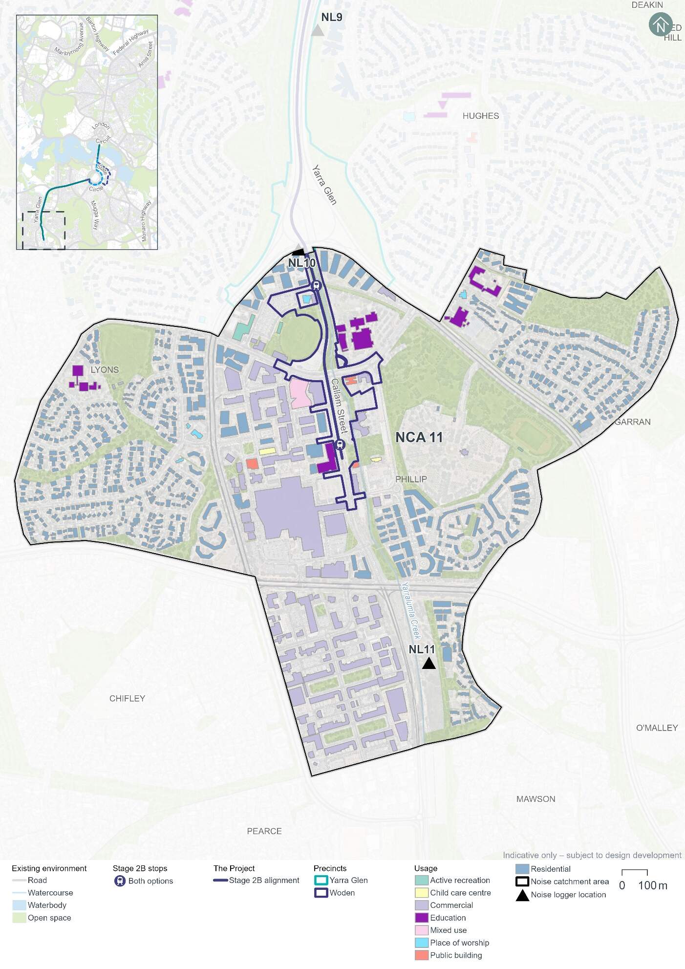
Noise Catchment Areas have been determined based on the general ambient noise environment of the area, and the types of receivers and land uses potentially affected by the Project. Noise Catchment Area 11 has been identified for the noise assessment of the Woden precinct. Noise Catchment Area 11 and associated sensitive receivers are shown in Figure 18-8.
The land uses within Noise Catchment Area 11 primarily consist of a mix of commercial properties of varying scale in the Woden Town Centre, including Westfield Woden, government offices, and hotels. There is also a large commercial area located south of Hindmarsh Drive. The residential areas of Lyons and Garran lie approximately 500 m west and 1 km east of Woden Town Centre respectively.
At the northern boundary of the catchment area, there are multiple residential apartment buildings, active recreation uses (including Phillip Oval), and educational land uses such as Canberra College and Saints Peter and Paul Primary School.
Existing noise levels
Unattended noise monitoring was carried out at one location in the Woden precinct (at noise logger 11 (NL11)) between 2 and 15 May 2024, and between 17 and 22 May 2024, to provide a representation of existing background noise levels. The results of this monitoring are summarised in Table 18-13. The LA90 level is the noise level exceeded for 90% of the sample period, and the LAeq level is the energy averaged noise level over the 15-minute period.
| Location ID | Noise logger address | Rating background level (LA90), dB(A)1 | Ambient noise level (LAeq), dB(A)1 | ||
|---|---|---|---|---|---|
|
Day2 |
Night2 |
Day2 |
Night2 |
||
|
NL11 |
21 Horbury Street, Phillip |
50 |
35 |
57 |
49 |
Notes:
- dB(A) represents A-weighted decibels, the relative frequency response used in sound measuring instruments.
- In accordance with the NSW Noise Policy for Industry (NSW Environment Protection Authority, 2017) time of day is defined as follows:
- Day - the period from 7 am to 6 pm Monday to Saturday or 8 am to 6 pm on Sundays and public holidays.
- Night - 10 pm to 7 am (Monday to Saturday); 10 pm to 8 am (Sundays and public holidays)
- Evening (not included in table) - the period from 6 pm to 10 pm.
Attended noise measurements were also carried out at each unattended monitoring location on 1 May 2024 during the daytime period. The results of this monitoring are summarised in Table 18-14.
| Location ID | LAeq dB(A) | LA90 dB(A) | Comments |
|---|---|---|---|
|
NL11 |
57 |
54 |
Some traffic noise from main road. Noise from construction site across the road dominant. Concrete pump operating constantly. |
18.3.2 Potential impacts - construction
The following sections present construction noise and vibration assessment results without the application of mitigation measures (referred to as unmitigated). Measures in Chapter 21 (Environmental management and mitigation measures) and Appendix L (Environmental Management Plan outline) would be implemented to manage these potential impacts. With the application of these mitigation measures it is expected that the unmitigated impacts would be noticeably reduced or, in some cases, avoided altogether.
Construction noise
Approach
In accordance with Section 29 and Item 16 of Schedule 2 Table 2.3 of the ACT Environment Protection Regulation 2005, construction of light rail or major roads do not require noise to be assessed against specific numerical noise limits as they are not taken to cause environmental harm. Item 16 of Table 2.3 places no conditions on the “Noise emitted in the course of constructing or maintaining a major road, a dedicated bus way, a railway or light rail.” Section 9.11 of the Environment Protection (Noise) Environment Protection Policy 2010 provides the following reasoning for the exemption of roadworks, noting that “the construction and maintenance of roads is central to the economic and social well-being of the community.”
In the absence of Territory specific quantifiable criteria, the NSW Interim Construction Noise Guideline (NSW Department of Environment and Climate Change, 2009) has been used to guide this assessment, as the Project would be of a large scale and occur within a relatively close proximity to noise sensitive receivers.
While construction noise generated by the Project is not required to be assessed against specific numerical noise limits, the derived assessment levels used in this EIS provide an indication of potential noise impacts to assist in the identification of appropriate mitigation measures, and were based on the NSW Interim Construction Noise Guideline (NSW Department of Environment and Climate Change, 2009).
The construction noise assessment presents a worst-case assessment which adopts conservative assumptions. For example, the noise model has used the shortest separation distance between worksites and each sensitive receiver, and has assumed the noisiest equipment would be in use. Actual construction noise levels experienced by receivers would generally be lower than the construction noise predictions. Modelling assumptions are discussed further in Technical Report 9 - Noise and vibration.
Scenarios
The noise assessment considers noise impacts from concurrent construction work across multiple precincts, but the results are reported at a precinct level.
The following construction scenarios have been modelled as a part of the noise and vibration impact assessment for the Woden precinct:
- Mobilisation and establishment of construction compound sites
- Protection, relocation, treatment and/or decommissioning of utilities
- Earthworks, road works and construction of light rail infrastructure
- Construction of stops
- Construction of bridges on land.
Finishing works, including rectification of any defects, would be carried out progressively during construction and have been considered in the assessment of each scenario described above. Testing and commissioning works are not expected to entail any additional noise and vibration impact beyond the standard operation of the Project; therefore a quantitative assessment has not been undertaken.
Construction activities for the Project would be undertaken between the hours of 7am and 6pm Monday to Saturday (standard construction hours), as far as practicable. As outlined in Section 6.5 of Chapter 6 (Construction), some work would likely be required outside of standard construction hours to minimise disruptions to traffic, minimise disturbance to surrounding landowners and businesses, and/or maintain safe and efficient operation of key roads and public transport facilities. Work proposed outside of standard construction hours would require assessment and approval on a case-by-case basis, as outlined in mitigation measure NV3 in Chapter 21 (Environmental management and mitigation measures).
All construction scenarios have been assessed based on work occurring during standard construction hours and during out of standard hours periods, with the exception of mobilisation and establishment of construction compound sites, which was only assessed as occurring during standard construction hours.
Construction noise scenarios have been categorised into 'peak and 'typical' works to represent the likely range of potential noise impacts. 'Peak' works represent the noisiest works which require the use of noise intensive equipment such as concrete saws and rock breakers, while 'typical' works represent typical noise emissions from a construction scenario when noise intensive equipment is not in use. Consequently, the 'typical' scenarios would result in a reduced number of noise affected receivers compared to 'peak' scenarios. Where possible, peak works and other high noise generating works would be carried out during standard construction hours. Should high noise impact activities be required to be undertaken outside of standard construction hours, they would be subject to specific controls identified in mitigation measures NV3 and NV4 (refer to Chapter 21 (Environmental management and mitigation measures)).
Assessment results
The number of residential buildings where receivers are predicted to be moderately or highly noise affected is shown in Table 18-15, which assumes no mitigation measures are in place. The number of buildings where noise levels are predicted to result in moderately affected receivers are separated into day and night-time periods, as appropriate.
The number of non-residential buildings predicted to be moderately noise affected is shown in Table 18-16.
Construction noise modelling has been completed assuming the noisiest equipment would be in use on the boundary of the Project area footprint, allowing for a worst-case scenario to be assessed. Section 3.2 of Technical Paper 9 - Noise and vibration provides further detail on the assessment approach.
Construction noise modelling indicates that there would be no difference in noise impacts in this precinct based on the alignment option selected.
|
Construction scenario |
Construction work category |
Predicted noise affected buildings1 (unmitigated) |
||
|---|---|---|---|---|
|
Standard construction hours - moderately noise affected |
Outside of standard construction hours (night-time) - moderately noise affected |
Highly noise affected2 |
||
|
Noise Catchment Area 11 |
||||
|
Mobilisation and establishment of construction compound sites |
Peak |
2 |
N/A |
5 |
|
Typical |
- |
N/A |
- |
|
|
Protection, relocation, treatment and/or decommissioning of utilities |
Peak |
17 |
57 |
23 |
|
Typical |
14 |
20 |
15 |
|
|
Earthworks, road works, and construction of light rail infrastructure |
Peak |
17 |
28 |
19 |
|
Typical |
16 |
21 |
17 |
|
|
Construction of stops |
Typical/peak |
2 |
7 |
4 |
|
Construction of bridges on land |
Peak |
7 |
20 |
9 |
|
Typical |
3 |
9 |
6 |
|
Notes:
- The noise levels in this assessment represent predicted noise levels at each building façade. Individual buildings have each been assessed as a single receiver, including where they are located at the same address or are part of the same facility. At multistorey buildings, the construction noise assessment documents noise levels for the most affected floor.
- Moderately noise affected receivers have been determined with consideration of the measured existing ambient noise levels, while the highly noise affected noise criteria do not consider existing ambient noise levels. Therefore, a receiver can be counted as both moderately noise affected and highly noise affected.
| Construction scenario1 | Building/area usage | Number of non-residential noise sensitive buildings assessed to be moderately noise affected2,3 (unmitigated) |
|---|---|---|
|
Noise Catchment Area 11 |
||
|
Mobilisation and establishment of construction compound sites - peak |
Public buildings |
1 |
|
Mobilisation and establishment of construction compound sites - typical |
Public buildings |
1 |
|
Protection, relocation, treatment and/or decommissioning of utilities - peak |
Active recreation |
2 |
|
Child care centre |
1 |
|
|
Education |
5 |
|
|
Place of worship |
1 |
|
|
Public buildings |
2 |
|
|
Protection, relocation, treatment and/or decommissioning of utilities - typical |
Education |
3 |
|
Place of worship |
1 |
|
|
Public buildings |
2 |
|
|
Earthworks, road works, and construction of light rail infrastructure - peak |
Active recreation |
1 |
|
Child care centre |
1 |
|
|
Education |
5 |
|
|
Place of worship |
1 |
|
|
Public buildings |
2 |
|
|
Earthworks, road works, and construction of light rail infrastructure - typical |
Education |
5 |
|
Place of worship |
1 |
|
|
Public buildings |
2 |
|
|
Construction of stops - typical |
Education |
1 |
|
Place of worship |
1 |
|
|
Public buildings |
1 |
|
|
Construction of bridges on land - peak |
Education |
4 |
|
Place of worship |
1 |
|
|
Public buildings |
1 |
|
|
Construction of bridges on land - typical |
Education |
2 |
|
Place of worship |
1 |
|
|
Public buildings |
1 |
|
Notes:
- Where a construction scenario did not result in an exceedance for a non-residential receiver, it has not been included in this table.
- Buildings have been assessed when in use, which is assumed to be the daytime period for most buildings, except hotels which have been assessed for day and night-time periods.
- The noise levels in this assessment represent predicted noise levels at each building façade. Individual buildings have each been assessed as a single receiver, including where they are located at the same address or are part of the same facility. At multistorey buildings, the construction noise assessment documents noise levels for the most affected floor.
The findings of the unmitigated peak and typical construction noise impact assessments for the Woden precinct during the daytime indicate:
- During standard construction hours, the protection, relocation, treatment and/or decommissioning of utilities is predicted to result 17 residential receivers being moderately noise affected.
- The 'peak' earthworks, road works and construction of light rail infrastructure is predicted to result in 11 non-residential receiver buildings being moderately noise affected, including CIT Woden, four buildings within Canberra College, two buildings at Phillip Oval, Koomarri, Woden Youth Centre, Woden Early Childhood Centre, and the Church of Pentecost Australia.
The findings of the unmitigated peak and typical construction noise impact assessments for the Woden precinct during the night-time period indicate:
- During out of hours, 'peak' protection, relocation, treatment and/or decommissioning of utilities is predicted to result in 57 receivers being moderately noise affected, and 23 receivers being highly noise affected.
- During out of hours, 'typical' earthworks, road works and construction of light rail infrastructure is predicted to result in 21 receivers being moderately noise affected, and 17 receivers are being highly noise affected.
- Hotel (commercial) buildings have also been assessed for the night-time period, however no hotels in the Woden precinct were predicted to be moderately noise affected.
Sleep awakening assessment
A sleep awakening assessment has been carried out using the 'typical' works case for each scenario, except for the mobilisation and establishment of construction compound sites (which has been assessed for standard construction hours only, and therefore not included in the assessment). The 'typical' works case has been used as it is assumed that noise intensive equipment (for example concrete saws and rock breakers) used for peak works would not be used during the night. The assessment approach is described further in Section 3.2 of Technical Report 9 - Noise and vibration.
Table 18-17 summarises the number of residential buildings where noise levels are predicted to exceed the awakening reaction criteria for Noise Catchment Area 11, in the absence of mitigation measures.
Work would be carried out during standard construction hours where possible, and work proposed outside of standard construction hours would require assessment and approval on a case-by-case basis, as outlined in mitigation measure NV3 (refer to Chapter 21 (Environmental management and mitigation measures)). It is unlikely that night works would involve several large-scale construction activities occurring concurrently, and works such as road works or track installation would generally move progressively along the Project area. Therefore, not all receivers would be affected at any one time, or for the whole duration of the works. As a result, the assessment of sleep awakening impacts is considered to be conservative. Proposed construction work hours are described further in Section 6.5 of Chapter 6 (Construction).
| Construction scenario (typical works) | Number of residential buildings where unmitigated noise levels may exceed the sleep awakening reaction level |
|---|---|
|
Protection, relocation, treatment and/or decommissioning of utilities |
45 |
|
Earthworks, road works, and construction of light rail infrastructure |
46 |
|
Construction of stops |
11 |
|
Construction of bridges on land |
20 |
Noting the awakening reaction level is exceeded by a number of residential buildings with noise relating to the following construction scenarios:
- Protection, relocation, treatment and/or decommissioning of utilities
- Earthworks, road works and construction of light rail infrastructure
- Construction of stops
- Construction of bridges on land.
The assessment and approval process for any out of hours works that cannot otherwise be avoided (as noted above, in accordance with mitigation measure NV3) would involve confirming mitigation measures to be applied and consultation with potentially affected receivers. Should extended periods of night work be required, respite periods would be scheduled.
Construction vibration
Vibration intensive work has the potential to cause human discomfort or cosmetic damage to buildings and structures, if not appropriately managed. Key potential sources of vibration from the proposed construction activities would include vibratory rollers, vibratory piling rigs, and excavators with hydraulic hammer attachments.
Table 4-3 of Technical Report 9 - Noise and vibration presents the minimum working distances to be maintained between vibration intensive work to avoid cosmetic damage or human discomfort. Appendix E of Technical Report 9 - Noise and vibration provides mapping of the minimum working distances for a large hydraulic hammer (which has been selected to represent one of the most vibration intensive pieces of equipment proposed to be used) for human response and cosmetic damage.
Human comfort
Potential exceedances of human comfort vibration criteria have been assessed for residential buildings. A number of residential buildings are located within the human response minimum working distance for a large hydraulic hammer (within 73 m of the Project area boundary). There is potential for exceedances of the human comfort criteria to occur depending on the duration, nature and location of the construction activity within the construction footprint. Any exceedances would be expected to be short in duration due to the intermittent nature of vibration emissions.
Cosmetic damage
A number of light-framed structures are located within the minimum working distance for a large hydraulic hammer (22 m for light-framed structures). No heritage-listed structures are located within the minimum working distance for a large hydraulic hammer (60 m for heritage and other sensitive structures) for cosmetic damage.
Where the use of vibration intensive equipment within the relevant minimum working distances cannot be avoided, detailed inspection, vibration monitoring and consultation with the sensitive receivers would be undertaken. Further information on mitigation measures is provided in Chapter 21 (Environmental management and mitigation measures).
Construction road traffic noise
Construction traffic associated with construction compounds would be distributed across the road network, with Easty Street and Callam Street being key construction traffic routes within this precinct. Section 6.7.1 of Chapter 6 (Construction) describes proposed heavy vehicle haulage routes. Heavy vehicle movements, which are likely to have the largest noise and vibration impact, would generally be for deliveries of construction plant, supplies and infrastructure, and to transport soil and waste materials.
A summary of the forecast 2031 traffic volumes without the Project, the additional traffic contributed by construction of the Project, and the resultant relative change in noise levels during the daytime (AM peak period, 8am to 9am) and night-time (10pm to 7am) are presented in Table 18-18. The year 2031 was selected as representative of the peak year of construction.
The majority of haulage routes would receive relative noise level increases of less than 2 dB(A). Changes in noise levels of up to 2 dB(A) are not considered to be perceptible by the average listener.
However, in the night-time hours, traffic both northbound and southbound on Easty Street between Launceston Street and Wilbow Street is predicted to exceed 2 dB(A) for an increase in noise levels. Residential receivers are located adjacent to the proposed haulage route sections of Easty Street. These receivers would potentially be affected by the increases in road traffic noise levels caused by the additional construction traffic for the Project. The increase in relative noise levels is driven by the low traffic on Easty Street during night-time hours, when compared to the AM peak. Noise mitigation measures would be implemented to manage this potential impact, as outlined in Section 18.3.4 and Chapter 21 (Environmental management and mitigation measures).
| Route | Direction | Existing traffic (average) | Additional construction traffic (hourly) | Relative increase, dB(A) | ||
|---|---|---|---|---|---|---|
| Light | Heavy | Light1 | Heavy1 | |||
|
Daytime assessment |
||||||
|
Easty Street between Launceston Street and Wilbow Street |
Northbound |
178 |
13 |
2 |
2 |
0.3 |
|
Southbound |
136 |
10 |
2 |
2 |
0.4 |
|
|
Callam Street between Neptune Street and Corinna Street |
Northbound |
477 |
36 |
2 |
2 |
0.1 |
|
Southbound |
325 |
24 |
2 |
2 |
0.2 |
|
|
Night-time assessment |
||||||
|
Easty Street between Launceston Street and Wilbow Street |
Northbound |
16 |
1 |
9 |
1 |
2.3 |
|
Southbound |
13 |
1 |
9 |
1 |
2.7 |
|
|
Callam Street between Neptune Street and Corinna Street |
Northbound |
44 |
3 |
9 |
1 |
1.0 |
|
Southbound |
53 |
4 |
9 |
1 |
0.8 |
|
Notes:
- Peak hourly volumes for additional construction light vehicles have been determined by first combining estimated volumes for construction activities and workforce and then halving for each direction. Peak hourly volumes for additional construction heavy vehicles have also been halved for each direction.
18.3.3 Potential impacts - operation
Operational rail noise and vibration
The following sections provide a summary of potential operational rail noise and vibration impacts in the Woden precinct. The potential impacts are common to both alignment options, given the consistent Project design in this precinct.
Airborne rail noise assessment
Operational rail noise levels were predicted at each of the receivers within 300 m of the alignment. This involved assessment of noise levels at a total of 131 receivers in the Woden precinct, including residential receivers, mixed use receivers, education and childcare centres, places of worship, public buildings and active recreation receivers, assuming no mitigation measures are in place. Operational rail noise was modelled based on indicative LRV design speeds identified along the alignment during the design development process.
The results of the operational rail noise assessment indicated that six sensitive receivers experience exceedances of the airborne noise trigger levels. The noise sensitive receivers that experienced exceedances of the LAFmax and LAeq,1hr noise trigger levels are presented in Table 18-19 and Table 18-20 respectively. At multistorey buildings, the airborne rail noise assessment documents noise levels for the most affected floor.
| ID | Usage | Address | Predicted LAFmax noise level, dB(A) | LAFmax noise trigger level, dB(A) | Exceedance dB(A) |
|---|---|---|---|---|---|
|
4395 |
Residential |
15 Irving Street Phillip |
81 |
80 |
1 |
| ID | Usage | Address | Predicted LAeq,1hr noise level, dB (A) | LAeq,1hr noise trigger level, dB(A)1 | Exceedance dB(A) |
|---|---|---|---|---|---|
|
2865 |
Education |
Canberra College Woden Campus, 40 Launceston Street, Phillip |
55 |
53 |
2 |
|
4122 |
Place of Worship |
The Church of Pentecost Australia-Canberra, 12 Irving Street, Phillip |
55 |
53 |
2 |
|
4361 |
Education |
Canberra College Woden Campus, 40 Launceston Street, Phillip |
63 |
53 |
10 |
|
4362 |
Education |
Canberra College Woden Campus, 40 Launceston Street, Phillip |
61 |
53 |
8 |
|
4431 |
Education |
CIT Woden Campus, Bradley Street, Woden |
56 |
53 |
3 |
Noise levels at the residential receivers northern façade at 15 Irving Street, Phillip, directly adjacent to Melrose Drive are exceeding the LAFmax noise trigger levels, however the exceedances of the trigger levels are 1 dB(A). As changes in noise level of up to 2 dB(A) are not considered to be perceptible by the average listener no further treatment is recommended.
The predicted LAeq,1hr noise levels for non-residential receivers are up to 10 dB(A) in excess of the trigger levels at receivers Canberra College and CIT Woden. Mitigation measures to manage potential impacts to these receivers are discussed in Chapter 21 (Environmental management and mitigation measures) of the EIS.
Ground-borne rail noise assessment
Ground-borne noise impacts for the Woden precinct at the most affected (closest) receivers are presented in Table 18-21.
No sensitive receivers are expected to experience ground-borne noise levels over the project trigger levels, and as such specific additional mitigation for receivers would not be required.
| Address | Building use | Distance from track centreline, m | Modelled speed of LRV, km/h | Ground-borne noise criteria (Night), dB(A) LASmax | Predicted ground-borne noise, dB(A) LASmax |
|---|---|---|---|---|---|
|
CIT Woden |
Education |
15 |
15 |
45 |
32 |
|
15 Irving Street, Phillip |
Residential |
20 |
50 |
35 |
35 |
|
50 Launceston Street, Phillip |
Residential |
29 |
50 |
35 |
33 |
|
Corner Callam Street and Matilda Street |
Residential |
33 |
60 |
35 |
32 |
Rail vibration assessment
The predicted vibration levels for the Woden precinct at the most affected (closest) receivers are presented in Table 18-22. No sensitive receivers are expected to experience vibration dose value over the nominated human comfort criteria.
| Address | Distance from track centreline, m | Vibration Criteria (Daytime), m/s1.75 | Predicted equivalent vibration dose value (Daytime), m/s1.75 | Vibration Criteria (Night), m/s1.75 | Predicted equivalent vibration dose value (Night), m/s1.75 |
|---|---|---|---|---|---|
|
Slovenian-Australian Association (12 Irving Street, Phillip) Commercial |
10 |
0.4 |
0.013 |
0.4 |
0.007 |
|
CIT Woden Education |
15 |
0.4 |
0.005 |
0.4 |
0.002 |
|
15 Irving Street, Phillip Residential |
20 |
0.2 |
0.008 |
0.13 |
0.004 |
|
50 Launceston Street, Phillip Residential |
29 |
0.2 |
0.006 |
0.13 |
0.003 |
|
Corner Callam Street and Matilda Street Residential |
33 |
0.2 |
0.007 |
0.13 |
0.004 |
Road traffic noise assessment
The assessment of road traffic noise has been completed in accordance with the Roads ACT Noise Management Guideline (Transport Canberra and City Services, 2018). The road traffic noise criteria applicable to upgrading roads in existing areas is presented in Table 18-23.
| Existing traffic noise level at adjacent buildings, LAeq,15hr | Traffic noise level at adjacent buildings after road works completed |
|---|---|
|
> 60 dB(A) |
Equal to existing level (not greater than 65 dB(A)) |
|
55 - 60 dB(A) |
60 dB(A) |
|
< 55 dB(A) |
Not more than 5 dB(A) above existing level |
To assess the potential impact of the Project on noise sensitive buildings, relative increases in future road traffic noise levels have been predicted for the 'without Project' and 'with Project' scenarios for the year 2031 (selected to represent the year of opening) and 2041 (selected to represent 10 years after opening). The future traffic volumes take into account increased traffic growth and changes to the road network from the Project such as changes in traffic lane configuration, signals and redirected traffic (described further in Chapter 5 (Project description)).
For the Woden precinct, existing road traffic noise levels are between 55 and 60 dB(A) and future predicted road traffic noise levels would not exceed 60 dB(A) and are therefore acceptable.
The results of the 2031 and 2041 road traffic noise assessment are presented in Table 18-24 to Table 18-27.
| Road assessed | Location | Direction | Traffic volumes without the Project (15hr) | Additional traffic with the Project (15hr) | Predicted relative increase noise level, dB(A) | Compliance | ||
|---|---|---|---|---|---|---|---|---|
| Light vehicle | Heavy vehicle | Light vehicle | Heavy vehicle | |||||
|
Athllon Drive |
21 Horbury Street, Phillip |
Southbound |
3,884 |
292 |
-582 |
-44 |
-1 |
Yes, no increase in traffic level |
|
Northbound |
8,767 |
660 |
-747 |
-56 |
||||
| Road assessed | Location | Direction | Traffic volumes without the Project (15hr) | Additional traffic with the Project (15hr) | Predicted relative increase noise level, dB(A) | Compliance | ||
|---|---|---|---|---|---|---|---|---|
| Light vehicle | Heavy vehicle | Light vehicle | Heavy vehicle | |||||
|
Athllon Drive |
21 Horbury Street, Phillip |
Southbound |
3,884 |
292 |
-1,132 |
-85 |
-1 |
Yes, no increase in traffic noise level |
|
Northbound |
8,767 |
660 |
-668 |
-50 |
||||
| Road assessed | Location | Direction | Traffic volumes without the Project (15hr) | Additional traffic with the Project (15hr) | Predicted relative increase noise level, dB(A) | Compliance | ||
|---|---|---|---|---|---|---|---|---|
| Light vehicle | Heavy vehicle | Light vehicle | Heavy vehicle | |||||
|
Athllon Drive |
21 Horbury Street, Phillip |
Southbound |
4,482 |
337 |
-393 |
-30 |
0 |
Yes, no increase in traffic noise level |
|
Northbound |
7,941 |
598 |
-393 |
-30 |
||||
| Road assessed | Location | Direction | Traffic volumes without the project (15hr) | Additional traffic with the Project (15hr) | Predicted relative increase noise level, dB(A) | Compliance | ||
|---|---|---|---|---|---|---|---|---|
| Light vehicle | Heavy vehicle | Light vehicle | Heavy vehicle | |||||
|
Athllon Drive |
21 Horbury Street, Phillip |
Southbound |
4,482 |
337 |
-1,022 |
-77 |
-1 |
Yes, no increase in traffic noise level |
|
Northbound |
7,941 |
598 |
-315 |
-24 |
||||
Fixed facilities noise assessment - Public Address systems
Public Address (PA) systems at light rail stops would present a fixed noise source during operations. Passenger announcements from PA systems at the various stops are likely to be infrequent and generally limited to emergency situations or where notable disruptions in service occur. The short-term nature of PA noise means that it is unlikely to dominate the LA10,15min assessment noise level at any location. Within the Woden precinct, stops are located at Phillip Oval and Woden Interchange.
The Phillip Oval Stop is located nearby to the sensitive receivers of the Slovenian-Australian Association and Church of Pentecost Canberra at 19 Irving Street, Canberra College at 2 Launceston Street, and nearby residential receivers. It is likely that the façade of the residences would have been designed to provide adequate insulation of road traffic noise, given they are relatively newly built. The subjective impacts are likely to be minimal given the relative infrequency of announcements, and existing background noise levels.
The stop is within the Woden Interchange where buses would be operating prior to the commencement of light rail operations. The stop at Woden Interchange is located approximately 45 m from the nearest residential receivers. As the Woden Interchange would already incorporate the use of PA systems, the subjective impacts of the noise from new light rail PA systems are likely to be minimal given the relative infrequency of announcements and the existing environment.
Fixed facilities noise assessment - Traction power substation noise
Within this precinct, TPS 10 would be located within the existing carpark off Spoering Street. The predicted TPS noise levels at the nearest affected receiver are presented in Table 18-26. Based on the assessment, the TPS design is anticipated to meet applicable noise criteria.
| TPS location | Distance to nearest receiver, m | Predicted LA10 noise level, dB(A) | Night-time noise zone standard, LA10,15min, dB(A) | Compliance |
|---|---|---|---|---|
|
TPS10 - Phillip |
50 |
27 |
35 |
Yes |
18.3.4 Precinct specific management and mitigation measures
Environmental management for this Project is detailed in Chapter 21 (Environmental management and mitigation measures). This includes construction and operational mitigation measures to manage noise and vibration impacts, that are applicable to the Project as a whole.
In addition to the Project-wide measures, mitigation measures to manage noise and vibration impacts that are specific to the Woden precinct are shown in Table 18-29.
| ID | Objective | Management and mitigation measure | Timing |
|---|---|---|---|
|
NV8 |
Minimising night-time construction road traffic noise |
Where night-time road traffic noise levels at sensitive receivers are predicted to increase by more than 2 dB(A), alternative construction vehicle haulage routes will be investigated. Where there are no alternative haulage routes available early consultation with the affected sensitive receivers will be undertaken. |
Construction |
18.4 Biodiversity
This section provides an assessment of the potential biodiversity impacts associated with the construction and operation of the Project for the Woden precinct. Impacts to biodiversity for the Project as a whole are discussed in Section 11.2 of Chapter 11 (Project-wide issues).Further detail on the biodiversity assessment is provided in Technical Report 2 - Biodiversity. The methodology applied for the assessment is summarised in Chapter 10 (Assessment methodologies) and Section 3 of Technical Report 2 - Biodiversity.
18.4.1 Existing environment
This section provides an overview of the existing environment with respect to biodiversity within the Woden precinct. Some biodiversity characteristics of the Project would extend across multiple precincts and are discussed in Section 11.2 of Chapter 11 (Project-wide issues) including habitat connectivity, vegetation assessments, threatened fauna habitat, threatened flora, and pest plants.
Vegetation assessment
A total of 3.89 ha of vegetation is present in the Woden precinct. Vegetation within the Woden precinct is comprised of three vegetation communities. Table 18-30 and Figure 18-9 depict the area and distribution of each vegetation community within the Woden precinct.
| Vegetation community | Area (ha) |
|---|---|
|
Landscape plantings - Native |
1.61 |
|
Landscape plantings - Exotic |
1.33 |
|
Exotic grassland |
0.95 |
|
Total vegetation |
3.89 |
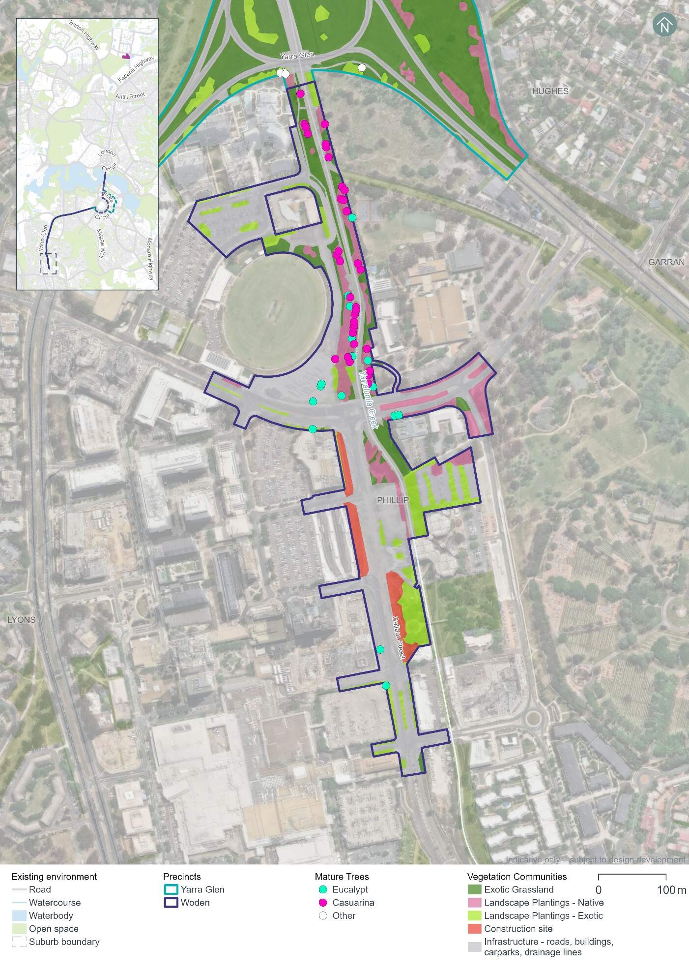
Hollow-bearing trees and mature trees
A total 51 mature trees were recorded in the Woden precinct as seen in Figure 18-9. These trees provide suitable breeding and/or foraging habitat for woodland birds including those identified as having a moderate or high likelihood of occurrence.
No hollow-bearing trees have been recorded in the Woden precinct.
A list of hollow-bearing and mature tree species across the Project area is provided in Section 11.2.1 of Chapter 11 (Project-wide issues).
Threatened fauna habitat
The Golden Sun Moth is listed as vulnerable under both the EPBC Act and the NC Act. A total area of 0.01 ha of potential Golden Sun Moth habitat has been recorded within the Woden precinct which was identified as low-density Chilean needlegrass habitat (refer to Figure 18-10). However, no Golden Sun Moth individuals have been recorded in the Woden precinct. Other Golden Sun Moth individuals, Populations, and habitat across the Project area are identified in Section 11.2 of Chapter 11 (Project-wide issues).
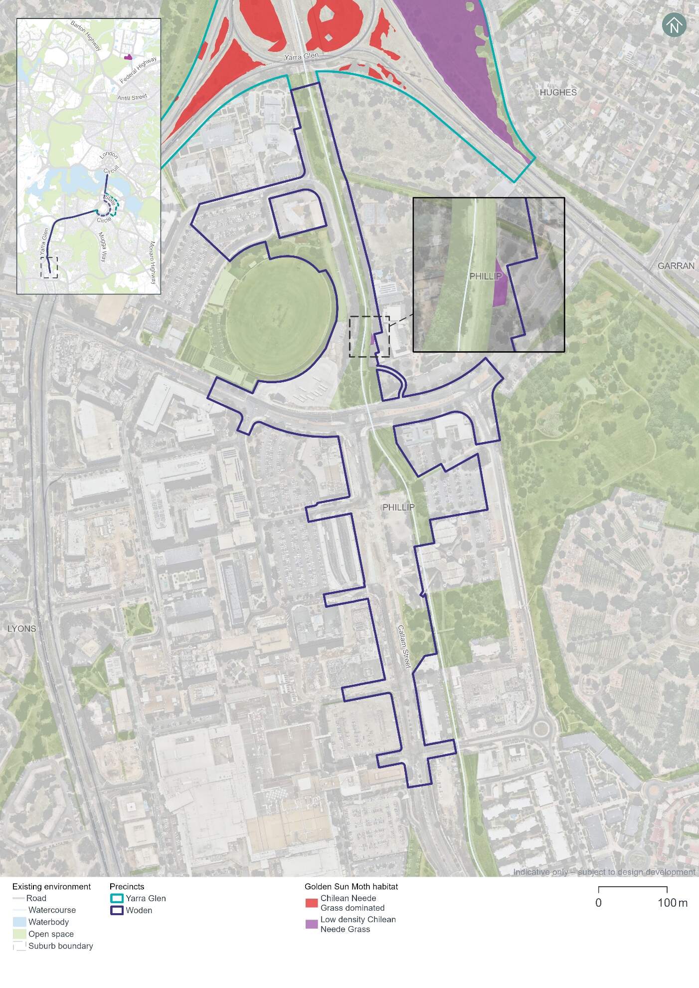
Other potential threatened fauna habitat identified within the Woden precinct includes:
- Gang-gang Cockatoo (listed as endangered under both the EPBC Act and the NC Act) - the Woden precinct supports 1.61 ha of foraging habitat for the species (refer to Figure 18-11)
- Superb Parrot (vulnerable under both the EPBC Act and the NC Act) - the Woden precinct supports 1.61 ha of foraging habitat for this species (refer to Figure 18-11)
- Diamond Firetail (listed as vulnerable under both the EPBC Act and the NC Act.) - 1.61 ha of the Landscape Planting - Native community has been identified within the Woden precinct and may provide suitable habitat for the Diamond Firetail (refer to Figure 18-11).
No habitat was identified in the Woden precinct for Swift Parrot (Lathamus discolor), Perunga Grasshopper (Perunga ochracea), Canberra Raspy Cricket (Cooraboorama canberrae), Key's Matchstick Grasshopper (Keyacris scurra), or Striped Legless Lizard (Delma impar).
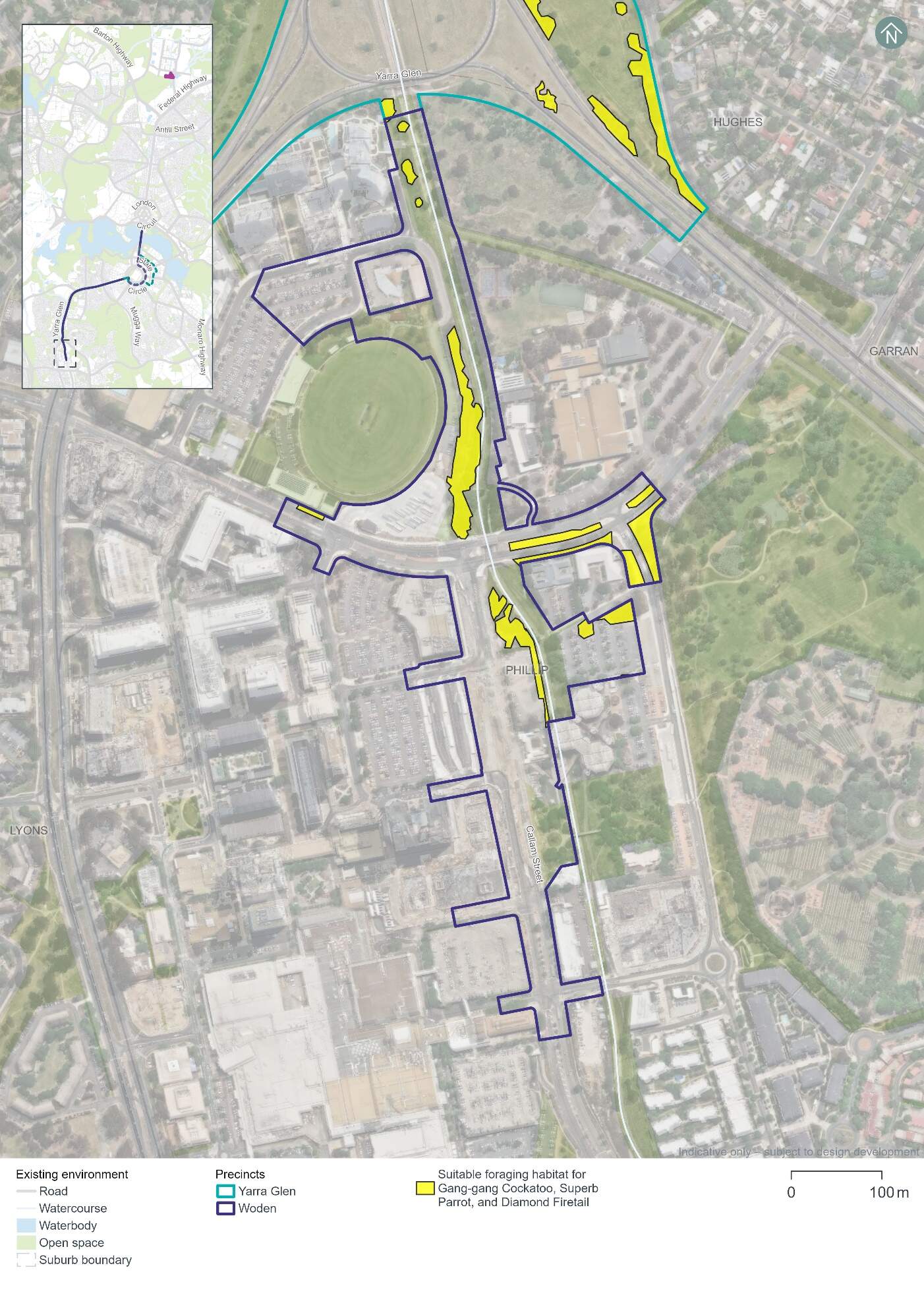
Threatened flora and pest plants
No threatened or rare flora species have been recorded in the Woden precinct. Impacts to threatened or rare flora species are therefore not anticipated.
Four pest plant species declared under the Pest Plants and Animals Act 2005 (PP&A Act) have been recorded in the Woden precinct:
- Chilean needlegrass (Nassella neesiana) - a Weed of National Significance
- African lovegrass (Eragrostis curvula)
- White poplar (Populus alba)
- Firethorn (Pyracantha angustifolia).
18.4.2 Potential impacts - construction
The following section summarises the potential impacts of the Project on biodiversity as a result of construction in the Woden precinct.
Vegetation assessment
The Project design has been developed with the aim of avoiding direct and indirect impacts to MNES and other biodiversity values in the landscape. Through this process, a clearance footprint has been defined, as shown in Figure 18-12. Vegetation clearing would not be permitted outside this clearance footprint.
Native and non-native vegetation within the clearance footprint is comprised of three communities as summarised in Table 18-31. Only 0.65 hectares of this vegetation is characterised as native, and all of it is landscape planting rather than remnant native vegetation.
| Vegetation community | Area (ha) |
|---|---|
|
Landscape Plantings - Native |
0.65 |
|
Landscape plantings - Exotic |
0.10 |
|
Exotic grassland |
0.48 |
|
Total vegetation |
1.23 |
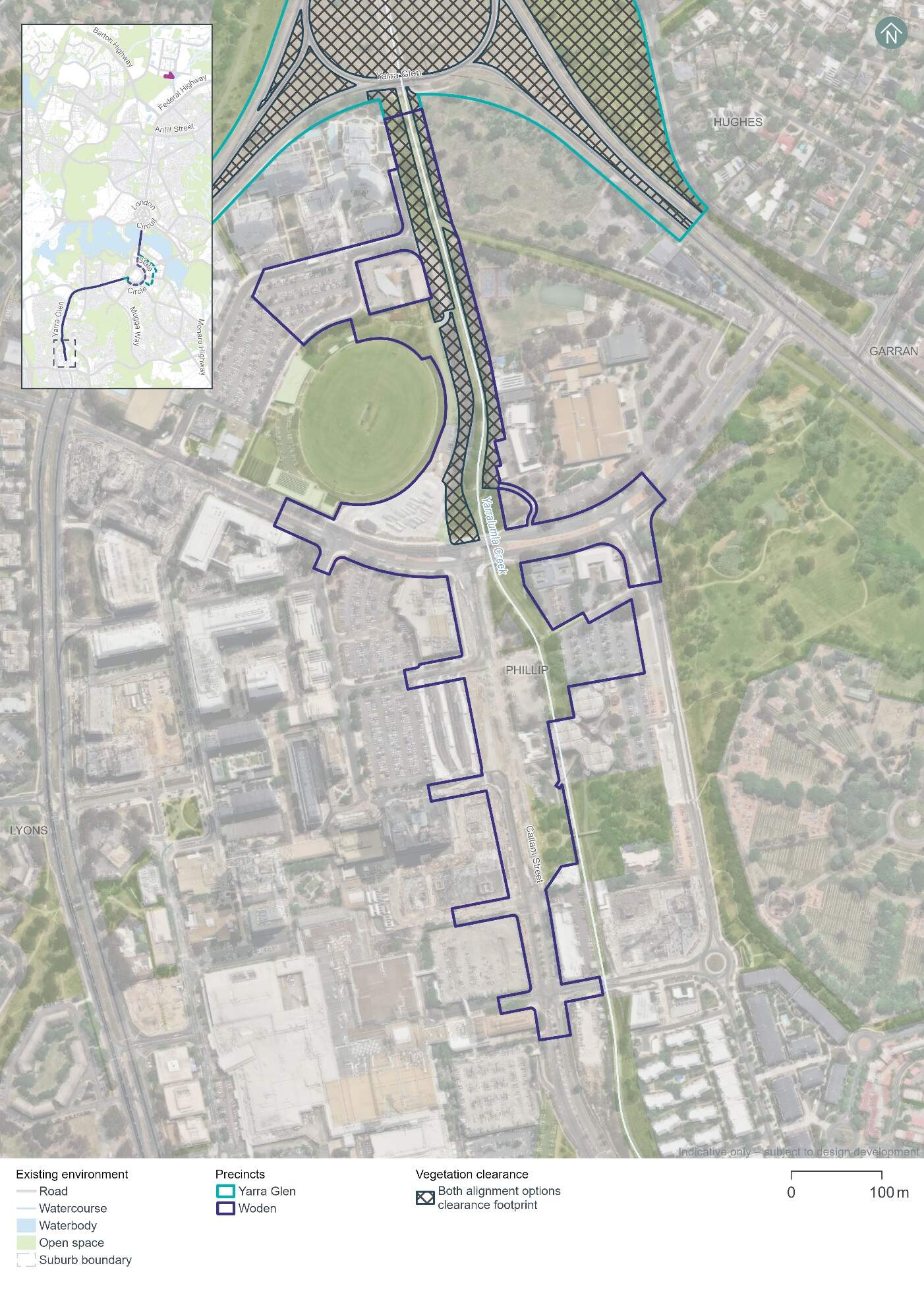
A total 31 mature native trees have been recorded in the clearance footprint in the Woden precinct. These trees provide suitable breeding and/or foraging habitat for woodland birds including those identified as having a moderate or high likelihood of occurrence.
No hollow-bearing trees have been recorded in the clearance footprint.
Threatened fauna
Potential impacts on threatened fauna within the clearance footprint in the Woden precinct would include impacts to the following through habitat removal:
- Golden Sun Moth - 0.01 ha of habitat
- Gang-gang Cockatoo - 0.65 ha of foraging habitat, which when taken in total with all clearing required for the Project, has the potential to interfere with the recovery of the species
- Superb Parrot - 0.65 ha of foraging habitat for Superb Parrot, which when taken in total with all clearing required for the Project, has the potential to interfere with the recovery of the species
- Diamond Firetail - 0.65 ha of Landscape Planting - Native vegetation which may provide suitable habitat for the species.
Potential impacts on threatened fauna habitat across the whole clearance footprint is discussed further in Section 11.2.2 of Chapter 11 (Project-wide issues).
No habitat has been identified in the Woden precinct clearance footprint for the Swift Parrot, Diamond Firetail, Perunga Grasshopper, Canberra Raspy Cricket, Key's Matchstick Grasshopper, or Striped Legless Lizard.
Indirect impacts
Native vegetation and habitat adjacent to the clearance footprint, and species using air space above the clearance footprint may be indirectly impacted by the construction works if appropriate management and mitigation measures are not implemented. Management and mitigation measures for biodiversity are discussed further in Chapter 21 (Environmental management and mitigation measures). Potential indirect impacts of construction activities may include:
- Spread of invasive species in the clearance footprint from equipment and machinery
- Noise and vibration impacts on fauna within the vicinity of construction works
- Erosion, sedimentation, and dust impacts on biodiversity values during ground disturbing works
- Waste impacts associated with the storage of fuels and disposal of waste from new equipment and the removal of existing infrastructure
- Increased light pollution on sensitive habitats and species from increased light spill and lighting intensity during construction works
- Fauna strike by construction vehicles within and adjacent to existing roadways.
Further detail on these indirect impacts for construction activities is discussed in Section 11.2.2 of Chapter 11 (Project-wide issues).
18.4.3 Potential impacts - operation
Native vegetation and habitat adjacent to the clearance footprint, and species using air space above the Project have the potential to experience indirect impacts from the operation of the Project, for example:
- Noise and vibration impacts within the vicinity of the alignment, from light rail operations
- Increased light pollution on sensitive habitats and species, for example due to lighting around light rail stops
- The addition of light rail vehicles within existing transport corridor would increase the risk of fauna strike
- Fauna strike with over-head wires and associated infrastructure.
Further detail on these indirect impacts for operational activities is discussed in Section 11.2.3 of Chapter 11 (Project-wide issues).
18.4.4 Precinct specific management and mitigation measures
The Project has sought to avoid and minimise impacts to MNES and other biodiversity values in the landscape, including through the development of a minimised clearance footprint within the Project area (refer to Figure 18-12).
Environmental management and mitigation measures are detailed in Chapter 21 (Environmental management and mitigation measures). This includes construction and operational mitigation measures to manage biodiversity impacts, that are applicable to the Project as a whole.
No precinct-specific measures have been identified for biodiversity impacts in the Woden precinct.
18.5 Historic heritage
This section provides an assessment of the potential historic heritage impacts associated with the construction and operation of the Project within the Woden precinct. Further detail on the heritage impact assessment is provided in Technical Report 3 - Heritage. The methodology applied for this assessment is summarised in Chapter 10 (Assessment methodologies) and discussed in detail in Section 2 of Technical Report 3 - Heritage.
Historic cultural landscapes, natural heritage, and heritage views and vistas have been assessed on a Project-wide basis as such features span across multiple precincts (refer to Section 11.3 of Chapter 11 (Project-wide issues)).
18.5.1 Existing environment
This section provides an overview of the existing historic heritage features within the Woden precinct. It also considers the condition, integrity, and sensitivity to change of historic heritage features within the precinct.
Heritage character
The heritage character of this precinct primarily arises from its position adjacent to the Woden Town Centre. Historically defined by Melrose Drive, Hindmarsh Drive, Callam Street, and Yarralumla Creek to the east, the precinct expresses the urban character of an early- National Capital Development Commission (NCDC) designed town centre (around 1960). This is reflected in the combination of government, retail, and community services arrayed in a cross shape around the town square and defined by the surrounding roads. The Callam Offices contributes to the expression of this heritage significance as a group of government offices adjacent to the town centre.
The historic heritage assessment identified two heritage places (one listed and one unlisted) near the Woden precinct, as noted below in Table 18-32 and shown in Figure 18-13.
| Heritage places | Description |
|---|---|
|
ACT Heritage Register |
|
|
Callam Offices |
The Callam Offices complex is significant, built in a late twentieth-century structuralist style of architecture by acclaimed architect John Andrews AO. It features elevated octagonal office pods interconnected by bridges displaying 'space-age' aesthetics. This enables the building to be above the 100-year flood level of Yarralumla Creek. The Callam Offices are a landmark of the Woden Town Centre, and of Canberra. |
|
Unlisted significant heritage places |
|
|
Canberra: the Planned National Capital |
Canberra's planned national landscape is a significant expression of the Griffin Plan that is highly valued by the Canberra and Australian communities. It is formed of public parklands, significant views along axes and across the Central National Area, tree-lined boulevards, a geometric layout, and Lake Burley Griffin. The landscape is nationally significant due to its:
Given this heritage place spans multiple precincts, it is assessed in Section 11.3 of Chapter 11 (Project-wide issues). It also applies to the landscape of Canberra as a whole and is therefore excluded from Figure 18-13 and is not considered further in this precinct assessment. |
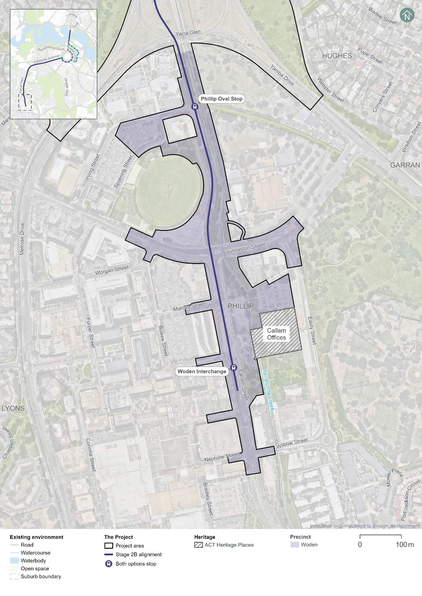
Condition, integrity, and sensitivity to change
The existing heritage values within the Woden precinct are generally in good condition. The Callam Offices is in fair condition.
The integrity of the heritage values is low to moderate. Changes over time have obscured and degraded the original form of the NCDC-era Town Centre plan, such as the recent addition of residential towers in the northern recreational precinct and general development within the Town Centre itself which has obscured the original layout centred around the Town Square.
This precinct has low to moderate sensitivity to change. The precinct's heritage character is via the expression of the NCDC-era planning for the precinct, for example the location, definition and form of the Town Centre, and its segmentation into different purposes. These features can tolerate a reasonable amount of change, but the loss of integrity that has already occurred and obscured the historic layer has reduced this tolerance.
18.5.2 Potential impacts - construction
Table 18-33 summarises the potential construction impacts of the Project on heritage places in the Woden precinct.
| Heritage place | Construction impact |
|---|---|
|
ACT Heritage Register |
|
|
Callam Offices |
Nil
|
Construction impacts on Canberra: the Planned National Capital have been assessed in Section 11.3 of Chapter 11 (Project-wide issues).
18.5.3 Potential impacts - operation
Table 18-33 summarises the potential operation impacts of the Project on heritage places in the Woden precinct.
| Heritage place | Construction impact |
|---|---|
|
ACT Heritage Register |
|
|
Callam Offices |
Nil
|
Operation impacts on Canberra: the Planned National Capital have been assessed in Section 11.3 of Chapter 11 (Project-wide issues).
18.5.4 Precinct specific management and mitigation measures
Environmental management for this Project is detailed in Chapter 21 (Environmental management and mitigation measures). This includes construction and operational mitigation measures to manage historic heritage impacts, that are applicable to the Project as a whole.
No further precinct-specific measures have been identified for historic heritage impacts at the Woden precinct.
18.6 Landscape character and visual amenity
This section provides an assessment of the potential landscape character and visual amenity impacts associated with the construction and operation of the Project within the Woden precinct. Further detail on the landscape character and visual amenity assessment is provided in Technical Report 10 - Landscape character and visual amenity. The methodology applied for the assessment is summarised in Chapter 10 (Assessment methodologies) and Section 2 of Technical Report 10 - Landscape character and visual amenity.
The landscape character assessment describes the physical, cultural, and heritage attributes of the landscape, planning designations, and desired character within each of the precincts. The assessment of visual impact has considered the impact of change on the views available to people and their visual amenity.
For the purposes of this assessment, the precinct boundaries have been expanded beyond the Project area, as shown in Figure 18-14.
18.6.1 Existing environment
Situated in the suburb of Phillip within the Woden Valley, the Woden precinct is characterised by the high density commercial, medical, large-scale retail buildings, and surface level carparking facilities. The new CIT campus and Woden Interchange are also notable landmarks in the Woden Town Centre. Yarralumla Creek comprises the lowest areas within this precinct, with the landscape rising to localised topographical peaks including Red Hill, Oaky Hill, Davidson Hill, Mount Mugga Mugga, and Issacs Ridge.
While not as heritage rich as other precincts, there are a small number of heritage items in the vicinity of the Woden precinct which contribute to the overall heritage value of the precinct. These include the ACT Heritage Register listed Callam Offices. Further information on the heritage items listed above can be found in Section 18.5.
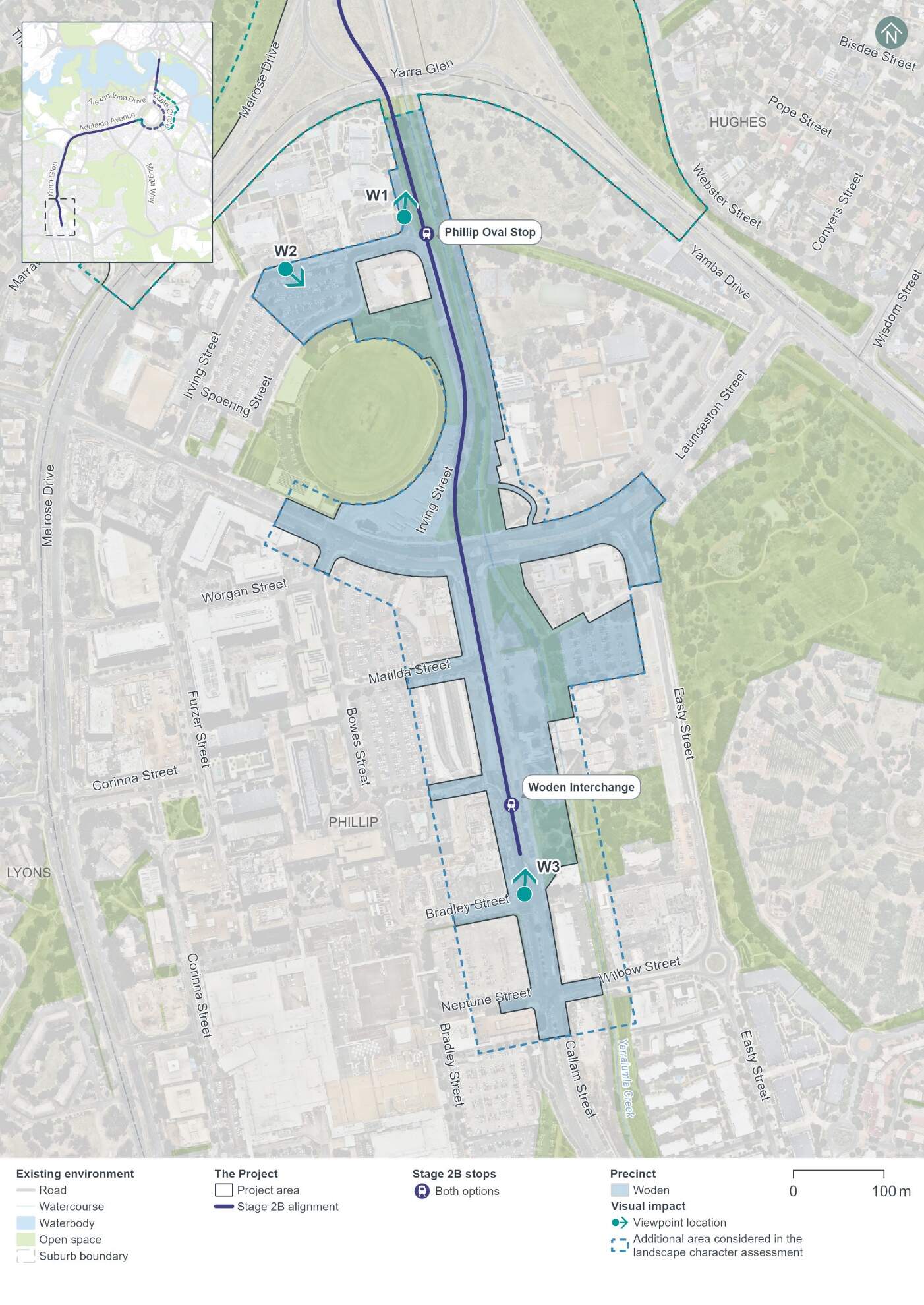
Landscape character
The key aspects of landscape character in the Woden precinct can be seen in Figure 18-15 to Figure 18-17. The topography within Phillip is typically flat to gently undulating, with Yarralumla Creek comprising the lowest areas within this precinct (refer Figure 18-15). Yarralumla Creek comprises an open concrete channel, flowing northwards from Mawson towards the Molonglo River. The landscape rises to localised topographical peaks including Red Hill, Oaky Hill, Davidson Hill, Mount Mugga Mugga, and Issacs Ridge.
Vegetation within the precinct is limited to areas of landscape plantings - native, which typically occur along Yarralumla Creek and to the eastern edge of the precinct. Some exotic street tree plantings line the roads within the township.
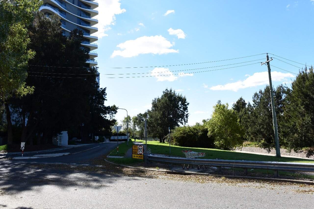
The street network within this precinct typically follows a grid system informed by the road network with a grid approach to allow for large-scale buildings in contrast to the more informal, curving residential streets to the east and west of the precinct. The suburb of Phillip is visually dominated by hardscape (refer to Figure 18-16), including high rise buildings and large areas of car parking (refer to Figure 18-17).
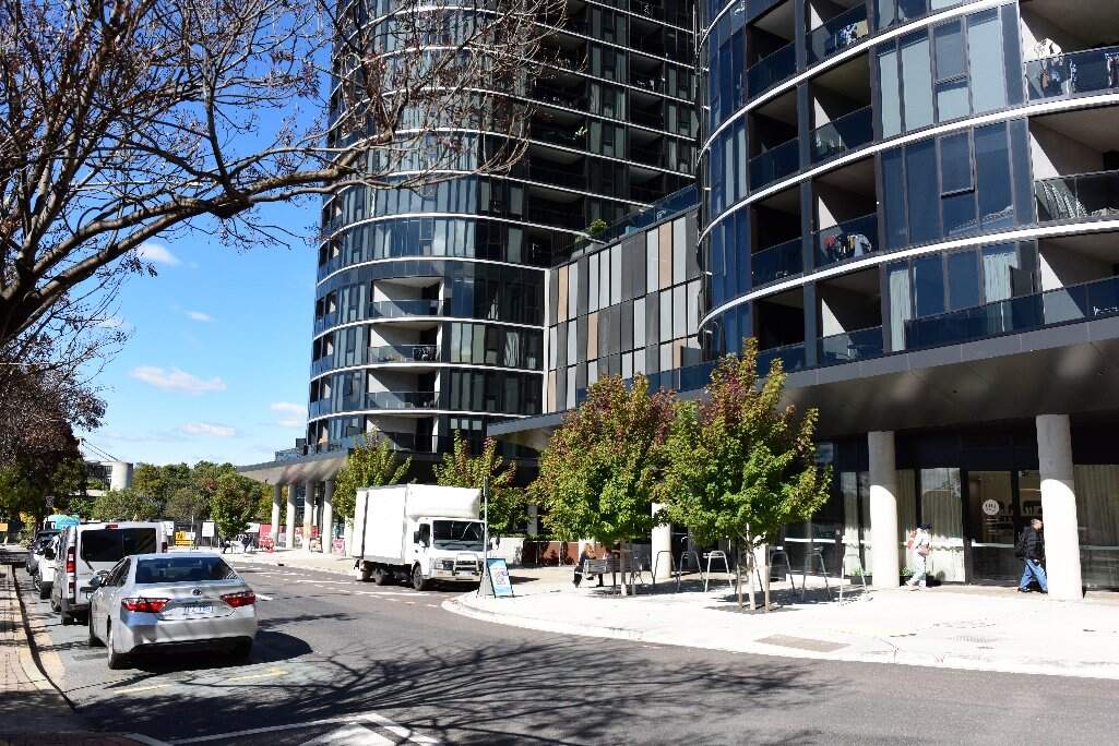
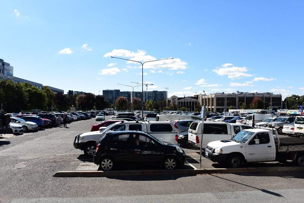
Viewpoints
Representative viewpoints that have been identified to assess changes to the Woden precinct which are and shown in Figure 18-14 and described in Table 18-35.
| Viewpoint | Description | Sensitivity rating |
|---|---|---|
|
Viewpoint W1: Irving Street |
The existing view from this location is shown in Figure 18-18. The foreground of this view includes a turf verge transitioning into the gravel of the adjacent community hub carpark. A row of trees extends along the turf verge into Irving Street. The midground comprises the unmarked, sealed carpark access road with road barrier transitioning into the Irving Street corridor. Visual receptors at this viewpoint would mostly be those travelling on the active travel path. A lower number of receptors would use the road, most of whom would be passers-by who see this view. The sensitivity of this viewpoint is moderate. Although it would have a high susceptibility to change due to the close proximity to the Project, many existing visual receptors are unlikely to be sensitive to these changes. |
Moderate |
|
Viewpoint W2: Traction Power Substation 10 |
This viewpoint looks west from the footpath of a street across a car park (refer to Figure 18-20). The fore and middle ground of the view are visually dominated by parked cars, with occasional deciduous trees partially screening the view to the background. High rise apartment buildings are seen in the background of the view, screening the view to the horizon. The sensitivity to change of this viewpoint is low. Motorists are unlikely to be a sensitive visual receptor group as they would be focussed on searching for a car park. Pedestrian receptors are likely to have a passing interest in the view. While residential receptors would typically be more sensitive to views surrounding their homes, this location is positioned within an area designated for car parking and with limited aesthetic value. |
Low |
|
Viewpoint W3: Callam Street at Bradley Street |
This viewpoint primarily comprises the Callam Street corridor including narrow concrete and gravel median (refer to Figure 18-22). To the left of the view, wire construction fencing lines the edge of the road with grassed areas visible through the fencing, as well as the far edge of a multi-storey carpark. A building is currently under construction on the north-west corner of the intersection. The sensitivity to change of this viewpoint is low. Motorists are unlikely to be a sensitive visual receptor group as they would only see the view for short periods of time, similarly, pedestrian receptors are likely to have a passing interest in the view. The planning and allowance for the Project within the future design of the town centre further lowers the viewpoints sensitivity to the Project. |
Low |
Night-time lighting
The Woden Town Centre in Phillip is a major commercial hub with high rise mixed use buildings and supporting facilities and therefore sits within an A4: High district brightness zone based on Australian Standard 4282:2023 (Standards Australia, 2023). The precinct is experiencing ongoing development and construction works and while these works are disruptive it is characteristic of a precinct undergoing urban renewal.
The Project passes Phillip Oval and terminates at the Woden Interchange adjacent to the CIT Woden campus. These venues are activity hubs which require a high degree of lighting, contributing to the A4 zoning.
The alignment within this precinct transverses different urban typologies. The lighting design outcomes would prioritise implementing the relevant policy objectives within the National Capital Authority's (NCA) Outdoor Lighting Policy, these include:
- Lighting must contribute to the creation of a high quality public realm
- Lighting must provide a safe night-time environment for residents of, and visitors to the National Capital
- Minimise the obtrusive effects of artificial lighting on the natural environment
18.6.2 Potential impacts - construction
Landscape character impact assessment
The construction of the Project would result in both the addition and loss of elements within the Woden precinct, including:
- The addition of temporary fencing, hoarding, signage, and traffic safety equipment
- Removal of existing vegetation (most notably, trees), furniture, and signage, as needed
- Activities including earthworks, track construction, drainage adjustments, and road improvements
- Construction of structures, including light rail stops, retaining walls, and bridges
- Installation of lighting, signage, and landscaping
- Temporary traffic changes
- Establishment of construction compounds.
These changes would alter many aesthetic aspects and key characteristics within the Precinct.
Construction activities in any one location would be temporary and experienced over the short term (up to five years).
As such, the magnitude of change during construction would be high within the Woden precinct due to the visual clutter of construction and the removal of trees. This would result in a high to moderate adverse impact on landscape character during construction.
Visual impact assessment
The visual impact assessment considered the sensitivity of existing viewpoints to change and the magnitude (scale, character, and distance) of the change of view. During the construction phase within the Woden precinct, in most cases the overall impact at each viewpoint has been assessed as being moderate to low due to:
- Moderate to low sensitivity of most viewpoints to change
- High to moderate magnitude of works anticipated throughout construction that would be visible within view of most viewpoints and construction occurring in neighbouring sites.
A description of the anticipated change in view and associated potential impacts on the Project during construction is provided in Table 18-36.
| Viewpoint | Anticipated change in view | Impact rating |
|---|---|---|
|
Viewpoint W1: Irving Street |
This location would not be accessible during construction; therefore, the visual impact would be negligible. As no changes would be seen from this viewpoint during construction, the magnitude of change experienced at this viewpoint would be negligible. This combined with a moderate sensitivity rating makes the overall impact negligible. |
Sensitivity: Moderate |
|
Magnitude: Negligible |
||
|
Overall impact: Negligible |
||
|
Qualitative rating: Neutral |
||
|
Viewpoint W2: Traction Power Substation 10 |
Construction of the TPS would be seen within a moderate portion of the view in the middle ground and would be in contrast to the existing view. While construction within this view would not involve tree removal, the addition of construction activities and equipment would comprise a high degree of contrast to the existing, established landscape. Construction activities would be visually prominent within the view, particularly due to the close proximity of the changes and the scale of the equipment. |
Sensitivity: Low |
|
Magnitude: High |
||
|
Overall impact: Moderate |
||
|
Qualitative rating: Adverse |
||
|
Viewpoint W3: Callam Street at Bradley Street |
Construction activities, especially of the Woden Interchange, would be seen within the road corridor in the middle ground of this view. Alongside other planned nearby projects, the visual clutter of construction activity would remain a dominant feature of the view, with additional large elements and construction activities evident within the view. |
Sensitivity: Low |
|
Magnitude: Moderate |
||
|
Overall impact: Moderate to Low |
||
|
Qualitative rating: Adverse |
Night-time visual impact assessment
Works in the Woden precinct may be required outside standard construction hours (Monday to Saturday, 7am to 6pm).
Night works would increase the existing light levels of this precinct. A construction compound within the precinct would be established within Easty Street car park in Woden, providing support for the construction activities. The construction compound would require temporary lighting to prioritise safety and security of the facility.
Lighting associated with night works within the precinct would be seen from surrounding commercial and residential properties.
For these reasons, the visual impact during construction at night would be minor adverse.
18.6.3 Potential impacts - operation
Landscape character impact assessment
The assessment of landscape effects considers how the Project would impact the landscape more broadly. It is based on the landscape's sensitivity to change and the expected scale of change. Table 18-37 summarises the anticipated changes and potential impacts of the Project on landscape character.
| Alignment option | Anticipated change | Impact rating |
|---|---|---|
|
Both alignment options |
The Project would result in the addition of light rail infrastructure within the Callam Street corridor in the precinct, as well as through the land reserve to the east of Phillip Oval. Further to this, minor adjustments to road arrangements, footpaths, and planting (particularly street trees) would be required. Tree removal to accommodate the active transport path would not be able to replace all trees lost, which would be an adverse qualitative outcome to small sections within the precinct. The addition of light rail adjacent to the Yarralumla Creek corridor would comprise a locally substantial change, particularly due to the removal of trees and the shift in land use from car park and 'back of house' area adjacent to a park to light rail, including a light rail stop at Phillip Oval. The addition of the light rail within Callam Street would characteristically align to a main road within a commercial centre. Overall, the changes would be beneficial to the landscape surrounding the Woden precinct with the addition of public transport infrastructure that fits into the main road corridor within a town centre. While existing active transport infrastructure north of Launceston Street would be impacted, the active transport route would be replaced on the eastern side of the creek, including portions of raised boardwalks which would protect the route from flooding. |
Sensitivity: Moderate |
|
Magnitude: Low |
||
|
Overall impact: Moderate to low |
||
|
Qualitative rating: Beneficial |
Visual impact assessment
The visual impact assessment considered the sensitivity of existing viewpoints to change and the magnitude (scale, character, and distance) of the change of view. During operation within the Woden precinct, in most cases the overall impact at each viewpoint has been assessed as being high to low due to:
- Low sensitivity of most viewpoints to change
- Viewpoints ranging from high to low magnitude of change, the main impact being views of passing LRVs and associated infrastructure.
A description of the anticipated change in view and associated potential impacts on the Project during operation is provided in Table 18-38.
| Viewpoint | Anticipated change in view | Impact rating |
|---|---|---|
|
Viewpoint W1: Irving Street |
The Project at operation would result in the addition of light rail infrastructure within this view. Planted trees would replace some (but not all) of those removed during construction. The new light rail stop at Phillip Oval would be visually dominant within the view. Those using the active travel path would be shifted to the eastern side of the creek and would not see this view along the light rail corridor. The Project would be seen across a large part of the view, including replacing an existing green space with the addition of a light rail stop, trackform and over-head wires extending into the distance, and passing LRVs. An indicative visualisation of the Project, once operational, from Viewpoint W1 is provided in Figure 18-19. |
Sensitivity: Moderate |
|
Magnitude: High |
||
|
Overall impact: High to moderate |
||
|
Qualitative rating: Adverse |
||
|
Viewpoint W2: Traction Power Substation 10 |
The TPS site would be around 270 m2, sitting within the middle ground, central portion of the view. The TPS would have a demountable building consisting of an air-conditioned switchgear room and a separate ventilated room. These changes would be seen within a small to moderate portion of the overall view, however, would comprise a new structural element within an existing car park. While these changes would be permanent and in contrast to the existing condition, the façade of the structure would be designed to be aesthetically recessive within the landscape. An example of a TPS from LRS1 is provided in Figure 18-21. |
Sensitivity: Low |
|
Magnitude: Moderate |
||
|
Overall impact: Moderate to low |
||
|
Qualitative rating: Neutral |
||
|
Viewpoint W3: Callam Street at Bradley Street |
The Project would result in the addition of light rail infrastructure within the existing central area of Callam Street. Light rail tracks would terminate on the northern side of the intersection. The Project would be seen from a slightly oblique viewing angle, but within the focal point of a road corridor as it extends away from the viewpoint. The changes, while positioned prominently within the view would be somewhat visually recessive, with the overall composition of the view subject to ongoing change in response to external projects. An indicative visualisation of the Project, once operational, from Viewpoint W3 is provided in Figure 18-23. |
Sensitivity: Low |
|
Magnitude: Low |
||
|
Overall impact: Low |
||
|
Qualitative rating: Neutral |
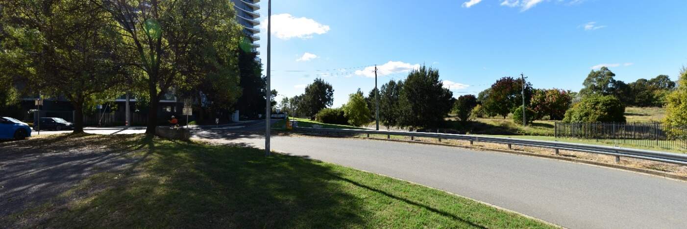
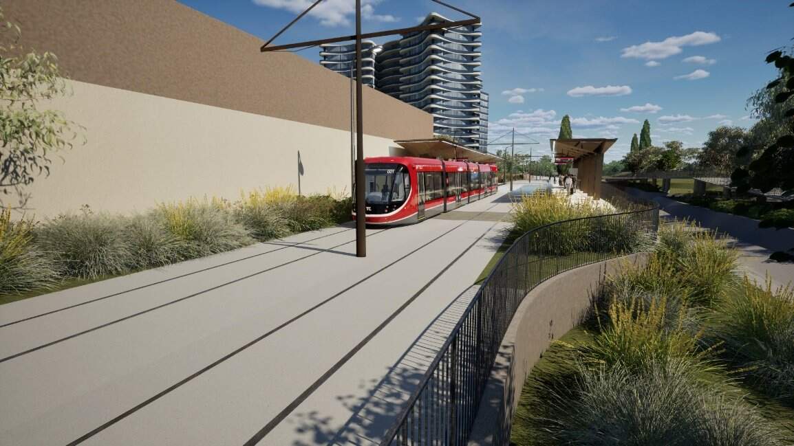
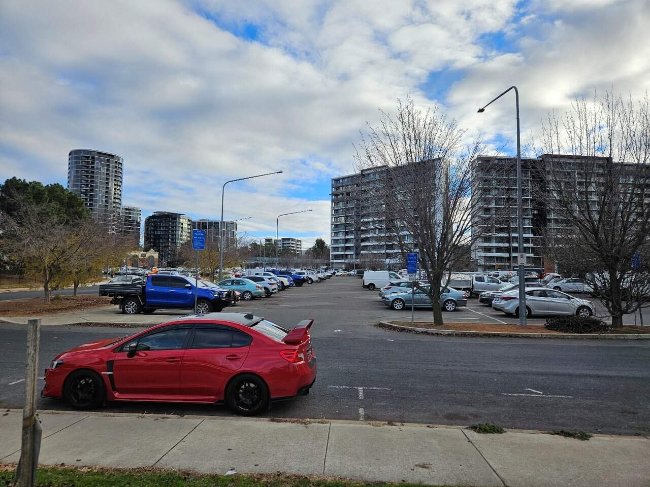
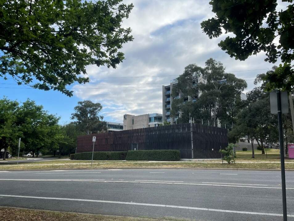
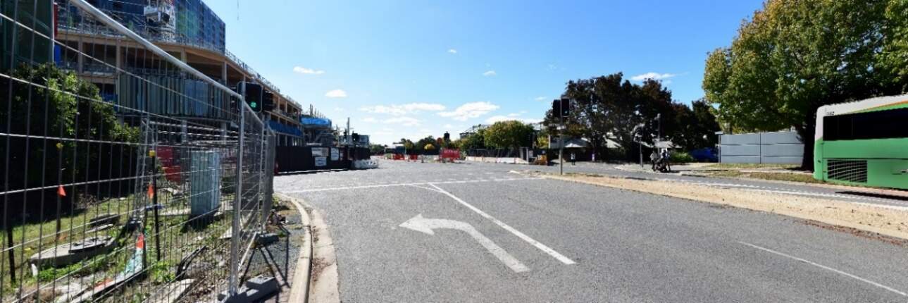
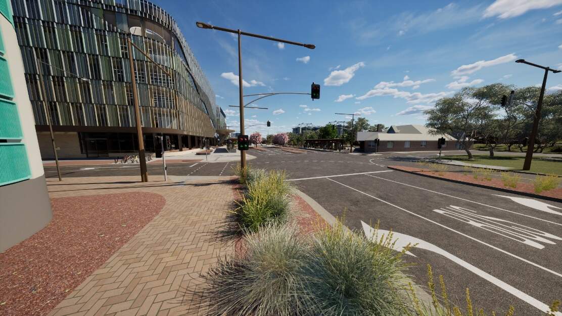
Night-time visual impact assessment
While the Project would introduce additional lighting, including LRV headlights along the tracks, the light rail corridor would align with the outcomes of the existing A4: High district brightness area.
The CIT Woden, its associated street lighting upgrade and the transport interchange upgrade, would provide sufficient lighting for the Project within the Callam Street corridor. Additional cut-off street and pedestrian lighting would be implemented along the corridor to the north of Launceston Street. This would contribute to high quality landscape and safety outcomes of the Project, while limiting the impact to the surrounding environment.
Removal of tree coverage to the western side of Yarralumla Creek surrounding the Phillip Oval area would result in an increase in light spill from both light rail lighting and the adjacent sporting facility into the surrounding vegetated area surrounding Yarralumla creek and Canberra College Woden Campus. An increase in tree canopy along the alignment and from other proposed developments would reduce the impact of lighting over time.
The light rail stops (Phillip Oval and Woden Interchange), would introduce additional lighting within the view corridor. Lighting of the stop is vital for passenger safety at night, however, the Phillip Oval Stop would establish a new lighting element adjacent to residential properties. The Phillip Oval Stop would result in light spill and a high degree of change. The Woden Interchange would not contribute a noticeable change to the surrounding landscape and receptors.
Low level strip lighting would be applied to the TPS 10 structure within the Spoering Street car park. The lighting would sit within the TPS structure, behind the façade, however minor light spill would occur through the façade.
Lighting associated with the Project would be designed to limit spill into non-target areas and up-lighting would be capped by structures. Light colour would be designed to complement the adjacent area and public safety cameras would be selected to function without unnecessary lighting.
While there would be a noticeable reduction in visual amenity at night due to the Project, particularly within the northern portion of the alignment, this is a high district brightness environment. The visual impact during operation would result in a minor adverse impact at night.
18.6.4 Precinct specific management and mitigation measures
Environmental management for this Project is detailed in Chapter 21 (Environmental management and mitigation measures). This includes construction and operational mitigation measures to manage landscape character and visual amenity, that are applicable to the Project as a whole.
In addition to the Project-wide measures, mitigation measures to manage landscape character and visual amenity impacts that are specific to the Woden precinct are shown in Table 18-39.
The Public Domain Master Plan (Appendix I) identifies design principles and guidance for the Project. These principles would be applied to the Project through ongoing design development and would contribute to management and mitigation of landscape and visual impacts of the Project during operation.
| ID | Objective | Management and mitigation measure | Timing |
|---|---|---|---|
|
LV3 |
Landscape enhancement in Phillip/ Woden |
Opportunities to soften landscape and visual impacts on the Phillip / Woden area will include consideration of:
|
Design |
|
LV10 |
Visual integration of traction power substations |
The scale and bulk of traction power substations will be refined to enable greater integration into the surrounding landscape. Material selection and finishes, lighting, landscaping and screen planting (including trees) will be used to minimise the visual presence of the substations. |
Design and operation |
18.7 Socioeconomic
This section provides an assessment of the potential socioeconomic impacts associated with the construction and operation of the Project within the Woden precinct. Further detail on the socioeconomic assessment is provided in Technical Report 6 - Socioeconomic. The methodology applied for this assessment is summarised in Chapter 10 (Assessment methodologies) and discussed in detail in Section 4 of Technical Report 6 - Socioeconomic.
Some socioeconomic impacts would be applicable to the Project as a whole (including this precinct) and are assessed in Section 11.7 of Chapter 11 (Project-wide issues).
18.7.1 Existing environment
Community characteristics
The social area of influence encompasses the geographical extent of a project's potential impacts on people, including how positive and negative impacts may be reasonably perceived or experienced by different people. The area of social influence forms the study area for this assessment and is shown in Figure 11-1 in Section 11.7.
The assessment has considered the following in defining the social area of influence for the Project:
- Precincts: this term is applied to a geographic area designated for the purposes of the Project where people are most likely to experience both construction and operational socioeconomic impacts from the Project, or a level of direct impact. Statistical Area level 2 (SA2) areas have been selected for each precinct to represent the community where direct socioeconomic impacts could potentially occur. The Phillip SA2 was analysed for the Woden precinct
- Corridor: this term is applied through the assessment where the spatial extent of socioeconomic impacts on people is generally broader than the precinct area. Statistical Area level 3 (SA3) areas have been selected to represent the corridor, including:
- South Canberra SA3
- Woden Valley SA3
- ACT: in some instances, the social area of influence is extended to a 'region' to reflect broader potential socioeconomic impacts, compared to the 'corridor'. This assessment refers to the 'region' as the Australian Capital Territory (ACT).
The characteristics of the communities within the area of social influence is described as the social baseline. The social baseline has been analysed by considering the human, social, economic, physical, and natural capital present around each precinct, the corridor, and the ACT. Capital refers to various forms of resources that contribute to the wellbeing, sustainability, and resilience of a community.
A summary of community capitals for the Woden precinct is provided in Table 18-40. Section 11.7 provides a summary of community capitals for the corridor and the ACT.
| Capital | Summary |
|---|---|
|
Human capital |
The population of 5,197 in this area is relatively young, with a strong presence of adults aged 25 to 34 and a slightly higher proportion of females (51.6%). A small percentage (1.7%) identify as Aboriginal and Torres Strait Islander. Educational attainment is notably high, with more than half of the population (55.6%) holding a bachelor's degree or higher. In terms of health, around a quarter of adults (23.4%) have one of four key risk factors, while a similar proportion experience long-term health conditions. Additionally, a small percentage of residents (2.9%) require assistance with core activities. |
|
Social capital |
In this area, 36.3% of the population speaks a language other than English, with Mandarin (3.5%) and Tagalog (2.5%) being the most common. Notable ancestries include Australian (20.7%), Indian (8.1%), and Chinese (7.1%). Family households make up just under half (49.8%) of all households, while 44.2% are single-person households. The community shows high mobility, with 35.8% of residents having lived at a different address one year ago and 77.4% having moved within the past five years. Volunteering rates are lower (13.1%). |
|
Economic capital |
Woden has a median total personal income of $1,342 per week and a median household income of $2,075 per week, reflecting moderate economic capital. Housing costs are also moderate, with the lowest median mortgage repayments at $1,608 per month and a median rent of $440 per week. Financial stress from mortgages is moderate (7.7%), while rent stress is relatively high (21%), indicating housing-related financial pressures. Woden has a high labour force participation rate (79.5%) and a low unemployment rate (3.4%). Key industries include Central Government Administration (19.4%) and Computer System Design (3.3%), with most residents working in Professional (38.6%) and Clerical and Administrative (14.3%) roles. |
|
Physical capital |
The area has a lower proportion of home ownership, with only 13.9% of properties owned outright and 34.8% owned with a mortgage, while rented properties account for nearly half (49.4%) of all housing. Most occupied private dwellings are flats or apartments (67%), with 32.8% being semi-detached, row, or terrace houses. The average household size is smaller, at 1.9 people. A significant portion of the working population walks to work (13.1%), and 9.9% use the bus, while the majority (56.5%) either drive or are passengers in a car. |
|
Natural capital |
The natural capital of the area includes key green spaces like Eddison District Park, Woden Town Park, and the Mount Taylor Nature Reserve, providing residents with access to nature and outdoor activities. These areas offer lifestyle benefits such as parks, gardens, and picnic spots for relaxation and recreation. Additionally, the community enjoys facilities for activities like skateboarding, enhancing the area's appeal for diverse age groups and active lifestyles. |
Social infrastructure
Social infrastructure comprises social services or facilities that are used for the physical, social, cultural, or intellectual development or welfare of the community. Social infrastructure within a 500 m buffer of the Woden precinct's area of social influence is shown in Figure 18-24.
The Woden precinct's social infrastructure includes parks, open spaces, playgrounds, sports playing fields, medical centres, education and research institutions, libraries, places of worship, swimming pools, cemeteries commercial/shopping centres, and law and emergency services facilities.
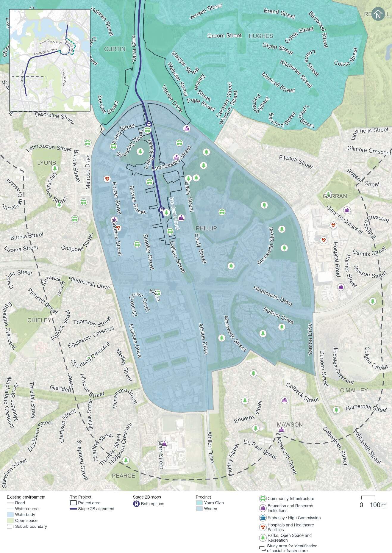
18.7.2 Potential impacts - construction
A summary of the potential socioeconomic impacts of the Project's construction for those living, working in or visiting the Woden precinct is provided in Table 18-41. Socioeconomic impacts within the Woden precinct would be common to both alignment options.
The significance of each impact has been evaluated taking into account its likelihood and magnitude, both before and after the implementation of proposed mitigation measures. The assessment approach is described further in Chapter 10 (Assessment methodologies) and Section 4 of Technical Report 6 - Socioeconomic.
The people most likely to be affected by change in this precinct would include those living in in the area, childcare centres, schools, and workplaces such as businesses and offices where people spend significant time daily. This precinct is also currently undergoing urban renewal with new developments such as the CIT Woden campus and a new public transport interchange enhancing connectivity.
Participants in consultation activities for the precinct (which are described in Chapter 4 (Stakeholder and community consultation)) indicated that construction noise and vibration and traffic disruption are key community concerns. Participants cited recent experience of construction noise impacts in the precinct and expressed concern with early morning and night-time works. A high proportion of consultation participants in this precinct indicated concern over existing traffic congestion and the cumulative impacts of other construction projects in the precinct with light rail construction perceived to exacerbate these delays (refer further to Chapter 20 (Cumulative impacts) for detail on potential cumulative impacts of the Project and other projects).
Although some construction impacts remain rated as medium even after mitigation, impacts are predominantly of low significance (once mitigated) and temporary. Impacts would be minimised through the implementation of the mitigation measures identified in Table 18-41 and Chapter 21 (Environmental management and mitigation measures).
| Description of impact | Pre-mitigation impact (likelihood/magnitude) | Mitigation approach | Mitigated impact (likelihood/ magnitude) |
|---|---|---|---|
|
Health and wellbeing Disruptions to local amenity during construction, potentially leading to a decline in health and wellbeing affecting workers, visitors, and residents. This may particularly affect people with disabilities or chronic illnesses. Changes to local amenity to this precinct are assessed further in Section 18.1.2, Section 18.3, and Section 18.6(in relation to traffic, noise and visual impacts, respectively). |
High (likely/ moderate) |
|
Medium (possible/ moderate) |
|
Disruptions to the road network and parking - impacts to accessibility for businesses, services, and workplaces Decline in accessibility to business and services due to temporary loss of parking during construction, including on-street parking on Irving Street and Spoering Street, and around 380 off-street spaces (and 11 motorcycle parking spaces) in the Easty Street, Phillip Oval, and Spoering Street car parks where construction compounds are proposed. Further detail on transport and access impacts within this precinct is provided in Section 18.1.2. |
High (likely/ moderate) |
|
Medium (possible/ moderate) |
|
Landscape and visual changes Changes to visual aesthetics and views would occur within the precinct however, large portions of the Woden Town Centre are under construction at present. Further detail on impacts to heritage and visual landscape in this precinct is provided in Section 18.5 and 18.6, respectively. |
Low (possible/ minor) |
|
Very low (unlikely/minor) |
18.7.3 Potential impacts - operation
A summary of the potential socioeconomic impacts of operation of the Project for those living, working in or visiting the Woden precinct is provided in Table 18-41. Socioeconomic impacts within the Woden precinct would be common to both alignment options.
Table 18-42 identifies socioeconomic impacts and evaluates the likelihood and magnitude of these impacts before and after the implementation of proposed mitigation measures. Where the impact is beneficial, this has been noted in Table 18-42. For beneficial impacts, measures which would enhance Project benefits have also been considered. The assessment approach is described further in Chapter 10 (Assessment methodologies) and Section 4 of Technical Report 6 - Socioeconomic.
During consultation activities for the Woden precinct, most consultation participants indicated benefits of light rail including alternatives to car travel and potential to improve the visual amenity of the landscape through tree planting and urban design.
| Description of impact | Pre-mitigation impact (likelihood/magnitude) | Mitigation or enhancement approach | Mitigated impact (likelihood/ magnitude) |
|---|---|---|---|
|
Landscape and visual changes Improvements to the aesthetic value of the area by creating attractive and active public spaces centred around light rail stops, that reflect the character of the surrounding area. Changes to the landscape and visual environment in this precinct are detailed in Section 18.6. |
Beneficial (likely/ positive) |
|
Beneficial (likely/ positive) |
|
Disruptions to the road network and parking - impacts to accessibility for businesses, services, and workplaces Decline in accessibility to business and services due to permanent loss of parking, including off street spaces. This includes the removal of 50 public parking spaces at the Phillip Oval car park and 33 spaces (and six motorcycle spaces) at the Spoering Street car park. Impacts to parking are detailed in Section 18.1.2. |
Low (possible/ minor) |
|
Very low (unlikely/ minor) |
|
Operational noise Potential decline in social amenity and ability to experience services due to operational rail noise impacts. Further detail on noise and vibration impacts in this precinct are detailed in Section 18.3. |
High |
|
Medium (possible/ moderate) |
|
Access and mobility Enhanced accessibility and safety for pedestrians and cyclists, including those with mobility constraints, through safety-related changes to active travel (e.g. enhanced active travel connection along Yarralumla Creek). This includes shared paths and two new pedestrian and cyclist bridges. Refer to Section 5.8 of Chapter 5 (Project description) for further detail on active travel arrangements. |
Beneficial (Likely/ positive) |
|
Beneficial (likely/ positive) |
18.7.4 Precinct specific management and mitigation measures
Environmental management for this Project is detailed in Chapter 21 (Environmental management and mitigation measures). This includes construction and operational mitigation measures to manage socioeconomic impacts, that are applicable to the Project as a whole.
No further precinct-specific measures have been identified for socioeconomic impacts at the Woden precinct.