About the M12 Motorway
Project information
The 16km M12 Motorway is a toll-free road connecting Elizabeth Drive in Cecil Hills with The Northern Road in Luddenham. The M12 Motorway will provide direct access to the new Western Sydney International Airport at Badgerys Creek via Warami Drive. The second stage of the project, opening mid-year includes the M7-M12 Interchange which will connect the M7 motorway to the M12.
An east-west 16 kilometre toll free motorway between Elizabeth Drive in Cecil Hills and The Northern Road, Luddenham.
A direct connection to Western Sydney International Airport.
A new connection to The Northern Road with traffic lights.
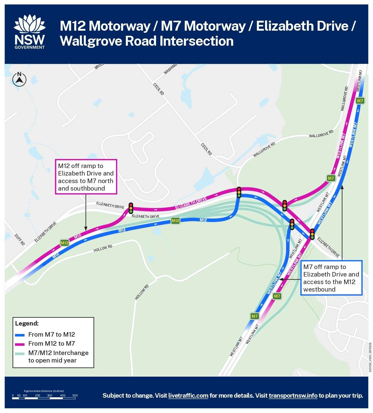
A motorway-to-motorway interchange at the M7 Motorway. (Stage 2 due to open mid 2026)
Provision for a future interchange connecting Mamre Road and Devonshire Road at the M12 Motorway.
A new shared path between The Northern Road and M7 Motorway with lighting and connections to future and existing shared path networks.
The M12 Motorway will be toll free
16 kilometres of new shared paths built with lighting for safety
Direct access into Western Sydney International Airport
Travel time savings of up to 16 minutes (once the M7-M12 Interchange opens)
Capacity of 52,000 vehicles per day
Four lanes with a wide median to build an extra lane in each direction in the future.
The motorway opened to traffic on Saturday 14 March 2026. Key connections to the motorway include The Northern Road, Warami Drive and Elizabeth Drive. Future connections to the M7 will open mid year.
The project has been split into three sections – East, West and Central. The Central and West sections have appointed two construction contractors Seymour Whyte (central) and CPB Georgiou Group Joint Venture (west). The East section will be delivered as part of the M7-M12 Integration project being managed by WSO Co who have engaged John Holland as the Design & Construct (D&C) Contractor.
M7-M12 Interchange
The M7-M12 Integration Project will support the growth of Western Sydney by widening the M7 Motorway and delivering a seamless connection to the 16-kilometre M12 Motorway to provide direct access to the new Western Sydney International Airport.
The project will deliver the M7 Motorway widening, by constructing one additional northbound lane and one additional southbound lane in the median to provide three lanes in each direction between the M5 Motorway and Richmond Road (excluding the Light Horse Interchange)
The M7-M12 Interchange, the connection between the M7 Motorway and the new M12 Motorway
Elizabeth Drive Connection that provides a connection to and from the new M12 Motorway and includes the widening of Elizabeth Drive and realigning Wallgrove and Cecil Roads.
The M7-M12 interchange is expected to open to traffic by mid-2026.
The M12 Motorway will open in stages to allow motorists to benefit from the new infrastructure as early as possible. The M12 motorway is expected to open in early 2026, providing immediate travel time savings and improved access to the local road network.
Construction of the M7-M12 interchange is continuing and is expected to be completed by mid 2026. Staging the opening ensures the community can begin using sections of the motorway safely and efficiently while remaining connections from the M7 motorway and Elizabeth Drive are completed.
Driving on the M12 Motorway
A variable speed limit applies on the M12 Motorway which means electronic signs will be displayed on the motorway where the speed limit can change based on road conditions. Motorists must adhere to the speed limit displayed on the signs.
If variable speed signs are blacked out, the speed limit on the M12 Motorway is 100km per hour. Motorists are encouraged to check signage and always adhere to the speed limit.
The new M12 Motorway will be toll free.
Motorists can choose to access the M12 via the untolled Elizabeth Drive or alternatively the tolled M7 Motorway.
The M12 Motorway will be built as a dual-carriageway motorway with two lanes in each direction and a central median to separate traffic lanes. The motorway also has capacity for an additional lane in each direction between the Western Sydney International Airport interchange and the M7 Motorway interchange.
The additional lanes would be based on future demand and funding.
Yes. If travelling the whole 16kms of the M12 Motorway instead of using Elizabeth Drive, you will save up to 16 minutes in travel time, once the M7-M12 interchange opens.
Driver animations for accessing the M12 are available on the website https://nswroads.work/M12. Additional animations will be shared as we work towards the opening of the M7-M12 Interchange in mid-2026.
There are 50 emergency bays positioned along the M12, each equipped with an emergency phone for direct contact with the Transport Management Centre. These bays are spaced no more than one kilometre apart—meaning motorists are always within 500 metres of a safe location to stop and seek assistance.
The motorway has been designed with a 2.5-metre-wide continuous shoulder lane, in line with national road design standards. This allows vehicles to pull over safely anywhere along the motorway in the event of a breakdown or emergency.
There are no height, load or width restrictions for any vehicles using the M12 Motorway.
Heavy vehicle drivers can access information on height, load and width restrictions on the Transport for NSW website. This website includes information for trucks in NSW and a NSW oversize mass load carrying vehicles network map.
Active Transport
A new dedicated 16 kilometre off-road shared path will be provided alongside the M12 Motorway between The Northern Road and Western Sydney Parklands. The shared path will travel through the Western Sydney Parklands and connect with the existing M7 shared path.
Accessing the new Western Sydney International Airport
Yes. Drivers can access Western Sydney International Airport via Elizabeth Drive from both the east and west. Elizabeth Drive has been upgraded to two lanes in each direction at the airport interchange, providing direct access to the new airport.
Yes. New signs will be installed along the M12 Motorway and across the broader Sydney road network to help direct drivers to Western Sydney International Airport. All airport signage has been updated to distinguish between Sydney’s two airports — WSI will identify Western Sydney International (Nancy-Bird Walton) Airport, while SYD will continue to represent Sydney (Kingsford Smith) Airport.
Pedestrians and cyclists will be able to access the new Western Sydney International Airport through a continuous shared path that runs alongside the M12 Motorway. The shared path connects to the broader active transport network, including links to Elizabeth Drive, The Northern Road, and local roads in Luddenham and Badgerys Creek.
The path provides a safe and direct route for cyclists and pedestrians, separated from motorway traffic, with connections to key entry points at the airport precinct. Additional wayfinding signage will be installed to guide active transport users to and from the airport and surrounding areas
Public Domain and Landscape Plan
The PDLP (Public Design Landscape Plan) forms part of the M12 Motorway project and illustrates how changes to the landscape will be designed in keeping with the physical context and cultural heritage of an area that has been part of the local Darug people and subsequent non-Aboriginal settlement. It will guide the implementation of landscape design that will be installed as part of the project including revegetation.
To learn more about the PDLP, please visit the virtual engagement room pdlp-virtual | M12 Motorway | Transport for NSW (RMS)
Key features of the design include:
a new shared pedestrian and cycling path, connecting the M7 Motorway, Western Sydney International Airport and the Northern Road
interpretation nodes that incorporate Aboriginal interpretation design into the built landscape and interpretation of non-Aboriginal heritage at locations along the shared path
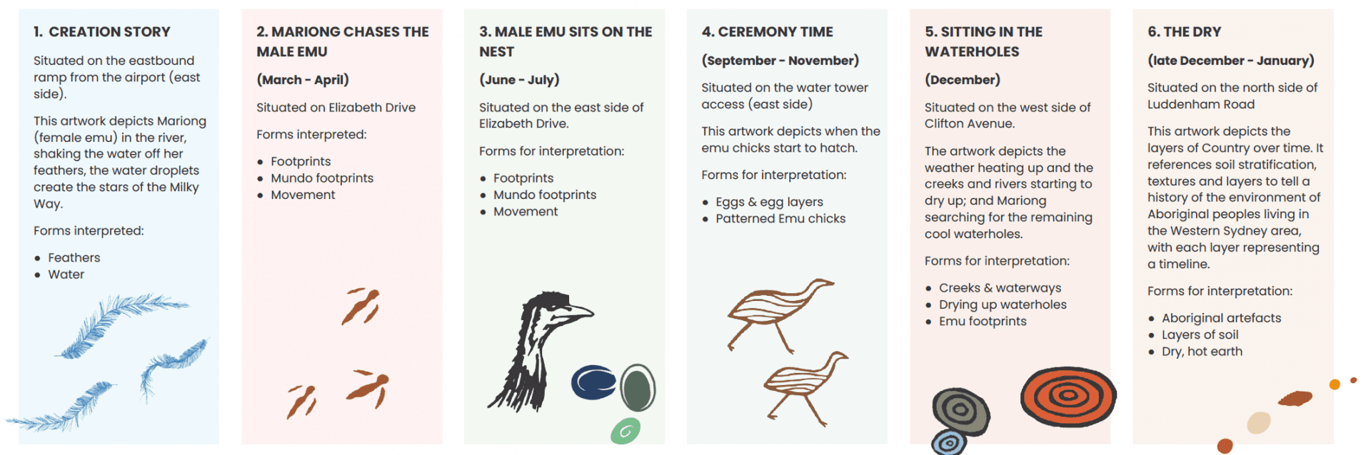
planting to reflect the calendar of six seasons observed by many Aboriginal groups
a new sculpture and landmark that celebrates the Darug Community’s sacred creation stories of the Great Emu constellation
screens embedded with the Great Emu story to feature on six overpass bridges.
Transport for NSW engaged Indigenous design agency, Balarinji from the early stages of the project to develop a detailed Designing with Country framework, curate public art and deliver interpretive content, to embed local Aboriginal heritage and culture within the M12 Motorway identity. Curated and co-created by Balarinji Studio with a cohort of Aboriginal artists, the artworks within the M12 corridor invite the traveller to learn and engage with Country.
Danny Eastwood (Ngemba)
Jamie Eastwood (Ngemba/Dharug)
Barry Gunther (Gandangara)
Danielle Mate (Murrawarri/Euahlayi)
Jasmine Seymour (Dharug)
Leanne Watson (Dharug)
Balarinji Design Studio ‘Great Emu in the Sky’ Balarinji lead conceptual artist on the work’s genesis, Tim Moriarty (Yanyuwa).
Located at the Western Sydney Airport interchange, ‘The Great Emu In The Sky’ sculpture is 30 metres high and depicts the Great Emu constellation. It tells the Dharug story of how Mariong, the Emu and Mother Spirit, became the Milky Way.
Co-created by Aboriginal artists: Danny Eastwood, Jamie Eastwood, Danielle Mate, Jasmine Seymour, Leanne Watson, and Balarinji Studio, and was conceived by Balarinji lead artist on the work’s genesis, Tim Moriarty.
Like the Great Emu constellation which changes throughout the Aboriginal six seasons, the sculpture uses dynamic lighting to reveal two emu forms, each only visible from certain viewpoints; one sitting on the nest and one in the night sky. The Aboriginal six seasons of Western Sydney are represented by projected colour washes that reflect the current season.
The sculpture refers to the Aboriginal principle of custodianship and knowledge sharing; you only see what you are meant to see and once knowledge holders share their stories with those who respectfully receive the information, it becomes obvious.
The sculpture that houses the illuminated emu forms is made up of mirrored signature branches and represents an emu nest. The branches refer to specific features of the Western Sydney landscape - creeks, ridge lines, silcrete.
The sculpture is visible from a number of viewpoints for motorists, pedestrians and cyclists, Metro passengers, and even travellers on flights approaching and departing from the Western Sydney International Airport
Adjacent to the M12 Motorway is a shared path and six rest nodes. The Eucalypt Canopy installations highlight the Aboriginal Six Seasons of Western Sydney through their tri-colour patterns. These installations invite travellers to experience the patterns and textures of the natural environment that is all around, if we pay attention and listen to Country.
There are three large leaf canopies, one at each entry point to the motorway, to act as welcome to Country landmarks, further expressing the theme of Aboriginal protocols and Interconnectedness. The third is located near the creek lines to acknowledge the importance of creeks and water systems within Aboriginal community and culture, particularly Wiannmatta – Mother Place (South Creek).
There are six smaller leaf canopies offering shade and lit at night, one at each rest node along the shared path representing each of the Aboriginal six seasons of Western Sydney.
Featured on the safety screens of the six overbridges along the M12 motorway are large scale reflective artworks that depict a seasonal Dharug story of the emu, including the Mariong Creation story. Created in co-design by Balarinji Studio with locally connected Aboriginal artists.
Vegetation and trees
The M12 Motorway project acknowledges that as part of construction, there will be impacts to existing vegetation including the removal of trees and endangered ecological communities, (including Cumberland Plain Woodland) across the project footprint. Transport for NSW commenced a tree survey along the length of the M12 Motorway alignment early on during the project lifecycle to understand the number of trees to be removed, habitat features and their potential for re-use. A total of about eighty-one hectares of native vegetation has been impacted by the project.
Approximately 18,500 native trees have been planted within the motorway corridor.
A seed collection and propagation program was undertaken, which has been designed to ensure the project can plan for planting and revegetation early on. The seed collection and propagation program aims to maximise the number of indigenous plant species from locally available seed for use in revegetation.
This program commenced two years prior to construction commencing and will continue until planting is completed.
1,6 million plants