Environmental Impact Statement Chapter 13.0 Parliament House precinct
Table of contents
Accessibility
This digital version of the EIS is designed to be accessible to all users, providing screen reader compatibility, keyboard navigation, and described images. If you require additional assistance or have specific accessibility needs, please contact us at lightrailtowoden@act.gov.au or call 1800 956 409.
13.0 Parliament House precinct
This chapter provides an assessment of potential impacts during operation and construction that relate to the Parliament House precinct and identifies mitigation measures to address these impacts. Environmental issues assessed in this chapter include:
- Traffic and transport (Section 13.1.4)
- Noise and vibration (Section 13.3)
- Biodiversity (Section 13.4)
- Historic heritage (Section 13.5)
- Landscape character and visual amenity (Section 13.6)
- Socioeconomic (Section 13.7).
The assessment of some aspects of traffic and transport, biodiversity, historic heritage, and socioeconomic impacts are applicable to the Project as a whole. These aspects have also been assessed in Chapter 11 (Project-wide issues).
Some additional environmental issues relevant to this precinct have been considered at a Project-wide level only in Chapter 11 (Project-wide issues), as the potential impacts and management approach associated with the issue are applicable to the Project as a whole.
13.1 Overview
The Parliament House precinct surrounds Capital Hill and Parliament House, forming the southern point of the National Triangle. The northern extent of the precinct begins on Commonwealth Avenue, immediately south of the intersection with Coronation Drive. It extends east around Parliament House along State Circle to Adelaide Avenue near its intersection with National Circuit. Most of the Parliament House precinct is within the Parliamentary Zone, where key national institutions, government buildings and significant landmarks are located, and which serves as the administrative and political hub of the country.
State Circle serves as a key transport connection between north and south Canberra, connecting Commonwealth Avenue with Adelaide Avenue and other main avenues such as Canberra Avenue and Kings Avenue. Views of Parliament House, key Federal Government department offices, and established native trees on the inner verge of State Circle enshrine Canberra as the 'Bush Capital' through this precinct.
For both options, the light rail alignment would pass around the southern side of Capital Hill and Parliament House through this precinct. To the west of Melbourne Avenue, it would transition from State Circle onto Adelaide Avenue via the landscaped annulus between State Circle and Capital Circle leading into a new light rail bridge over State Circle. Within the Parliament House precinct, the light rail would be wire-free.
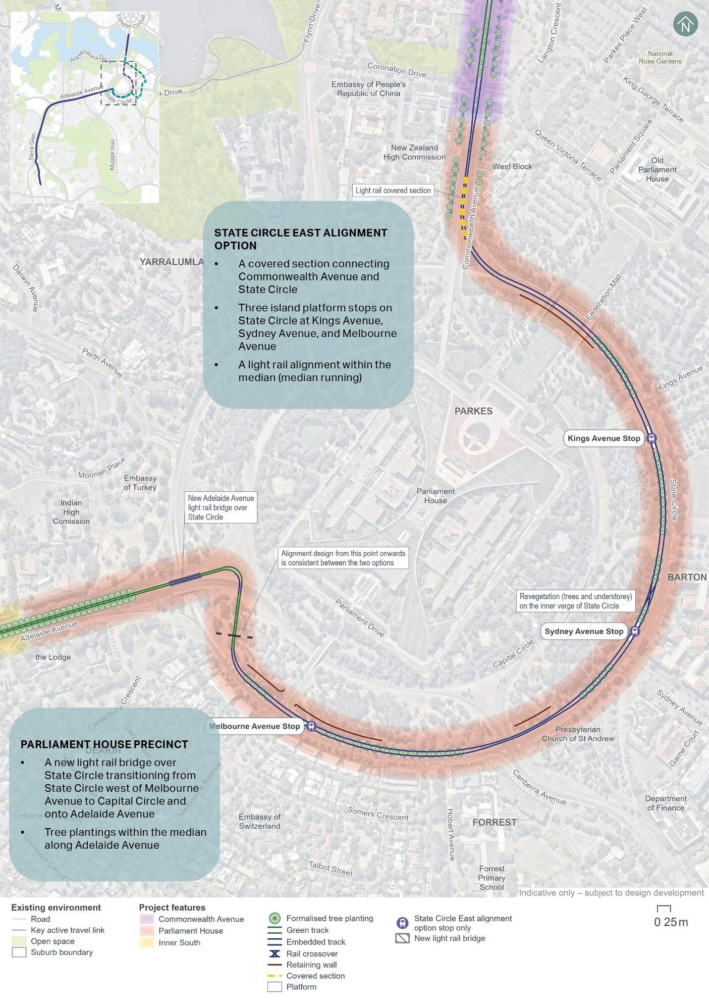
13.1.1 State Circle East alignment option
Within Parliament House precinct, the State Circle East alignment option would transition from the Commonwealth Avenue road corridor into a covered section about 125 m in length. This covered section would allow the light rail to pass underneath southbound Commonwealth Avenue traffic lanes through to State Circle, both northbound and southbound.
For the State Circle East alignment option, light rail would run within the median (median running) and would include three stops located within the median of State Circle:
- Kings Avenue Stop, located immediately to the south of Kings Avenue
- Sydney Avenue Stop, located immediately to the north of Sydney Avenue
- Melbourne Avenue stop, located immediately to the east of Melbourne Avenue.
The State Circle road corridor would be widened into Capital Hill, generally between Commonwealth Avenue and Adelaide Avenue, by up to around 20 m to accommodate the light rail median running arrangement. Widening into Capital Hill would be greater at intersections along State Circle to accommodate all existing turning movements, by up to around 25 m at Canberra Avenue and 28 m near Melbourne Avenue.
Key Project features within this precinct for the State Circle East alignment option are shown on Figure 13-1.
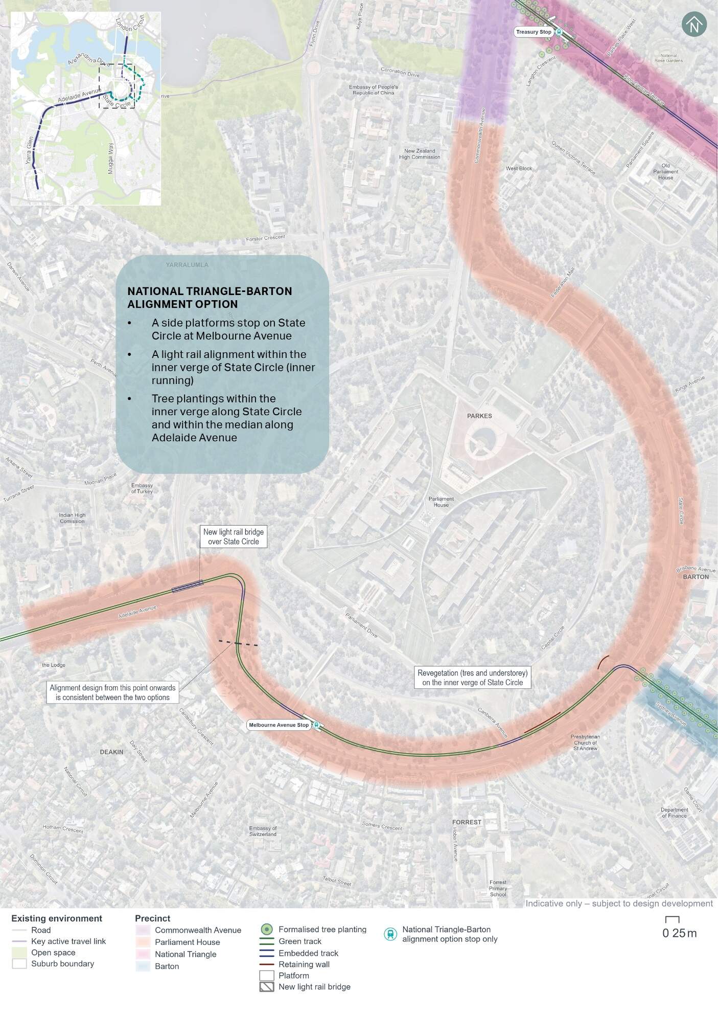
13.1.2 National Triangle-Barton alignment option
The National Triangle-Barton alignment option would transition into the Parliament House precinct after it traverses the National Triangle and Barton precincts at the State Circle intersection with Sydney Avenue. This alignment option runs on the inner road verge (inner running) of State Circle until its transition onto Adelaide Avenue.
The National Triangle-Barton alignment option would include one stop within this precinct (Melbourne Avenue Stop), located on the inner road verge of State Circle immediately east of its intersection with Melbourne Avenue.
The State Circle road corridor would be widened into Capital Hill, generally between Sydney Avenue and Adelaide Avenue, by up to around 22 m to accommodate the light rail inner running arrangement. Widening into Capital Hill would be greater at intersections along State Circle to accommodate light rail infrastructure, by up to around 35 m at Sydney Avenue, 27 m at Canberra Avenue and 29 m near Melbourne Avenue.
Key Project features within this precinct for the National Triangle-Barton alignment option are shown on Figure 13-2.
Refer to Chapter 5 (Project description) for a more detailed description of the Project within this precinct.
13.1.3 Key construction activities
Construction activities required within this precinct would be generally similar to those required across other precincts. Construction activities are considered at a Project-wide level within Chapter 6 (Construction).
Key construction activities within the Parliament House precinct would include construction of the Adelaide Avenue light rail bridge over State Circle (refer to Section 6.3.4). This would involve ground preparation, piling, installation of key bridge elements, barriers, trackform and rails, and finishings.
For the State Circle East alignment option, construction of the covered section between Commonwealth Avenue and State Circle would be carried out in this precinct. A 'cut and cover' construction method is proposed for construction of this covered section, which is described further in Section 6.3.5. This would generally involve construction of a soil retaining structure (e.g. piles, walls and supports), excavation works, and installation of track, drainage, combined services route, fit-out and finishes.
Both options would require some widening of the road corridor on the inside edge of State Circle, into Capital Hill. This would generally involve relocating utilities, relocating inner kerb lines, reconstruction of drainage, and reconstruction of the inner verge including retaining walls. Following this, excavation for light rail stops and trackform, intersection reconfiguration and construction, and trackform and stop construction would be carried out.
Compound F (Capital Hill West) is the only construction compound within Parliament House precinct. The location of the compound is shown on Figure 6-1 in Chapter 6 (Construction).
13.1.4 Environmental impact overview - construction
Key impacts within the Parliament House precinct from the construction of the Project are summarised below, and assessed in further detail in this precinct-based assessment chapter.
Two potential alignments for the Project are being considered through the Parliament House precinct - the State Circle East alignment option and the National Triangle-Barton alignment option. The potential impacts of each alignment option has been assessed in this chapter. Unless specifically noted, impacts in this overview are discussed for both alignment options. Through further design development, construction planning and the selection of a single, final alignment option, environmental impacts are expected to be further minimised.
Traffic and transport
Construction of the Project would be undertaken within and adjacent to the road reserve, and as such would result in localised traffic impacts, including temporary road closures, changes to turning movements, and the introduction of heavy vehicle traffic, which would disrupt the road network and parking availability. Broader road network impacts are assessed in Chapter 11 (Project-wide issues).
Within this precinct, depending on the alignment option selected, specific impacts would include restricted right turns at key intersections, such as State Circle and Kings Avenue, and changes to property access points, which may result in increased travel times for motorists.
The construction activities would also lead to a temporary, staged loss of 46 on-street parking spaces across the precinct as construction works progress.
Activity- and site-specific traffic management measures would be developed and implemented through the Construction Environmental Management Plan(s) for the Project, with a focus on managing construction related traffic and site access, parking availability, and the adequate performance of the road network in proximity to construction site accesses and haulage routes. Notwithstanding, construction would result in residual traffic impacts following the implementation of these measures. Construction planning would continue with the aim of minimising disruption to the road and transport networks.
Noise and vibration
Construction activities, including earthworks, road works, and the establishment of construction compounds, are expected to generate noise that could moderately to highly affect nearby residential and non-residential buildings during the day and night, particularly during 'peak' construction scenarios (representing the noisiest works that require the use of noise intensive equipment such as concrete saws and rock breakers).
In the night-time hours, receivers located adjacent to the proposed haulage routes on parts of Flynn Drive and State Circle may be affected by the increases in road traffic noise levels (in instances where night works are required).
Mitigation measures that would be implemented to manage impacts, such as scheduling to minimise high-noise activities outside of standard construction hours, are expected to reduce the identified potential impacts. Works outside of standard hours would also require assessment and approval on a case-by-case basis. Despite these measures, some temporary disturbances are anticipated, but they are expected to be minimised through construction planning and community consultation.
Biodiversity
The Project design has been developed with the aim of avoiding direct and indirect impacts to Matters of National Environmental Significance (MNES) and other biodiversity values in the landscape by minimising the construction footprint. Despite this, some clearing of native vegetation and habitat for species protected under the Environment Protection and Biodiversity Conservation Act 1999 (EPBC Act) and The Nature Conservation Act 1992 (NC Act) would be required to construct and operate the Project. This would include a total of 7.08 hectares of vegetation within the Parliament House precinct, 2.46 hectares of which is characterised as native.
Removal of this vegetation would impact suitable habitat for the Golden Sun Moth (listed as vulnerable under the EPBC Act and NC Act), breeding and foraging habitat for the Gang-gang Cockatoo (endangered under the EPBC Act and NC Act) and the Diamond Firetail (vulnerable under the EPBC Act and NC Act), and foraging habitat for the Superb Parrot (vulnerable under the EPBC Act and NC Act) and Swift Parrot (endangered under the EPBC Act and NC Act). Ten hollow-bearing and 60 mature native trees, which provide suitable breeding and/or foraging habitat for woodland birds, have also been identified along State Circle in the proposed clearance footprint for the Project.
Opportunities to further avoid or minimise biodiversity impacts, and to enhance habitat and connectivity through Project landscaping would be considered through ongoing design development. A Biodiversity Offset Strategy has been developed for the Project to manage residual impacts which are unable to be avoided, and would be updated to reflect any further avoidance or minimisation of biodiversity impacts achieved through ongoing design development.
Other impacts
Other potential construction environmental impacts identified in this precinct-based assessment chapter include:
- Heritage: Several places listed on Commonwealth and ACT Heritage registers are present in the precinct including the State Circle Cutting, West Block and the Dugout, Commencement Column Monument, York Park North Tree Plantation, and The Presbyterian Church of St Andrew. While direct impacts have been avoided, these places have the potential to be indirectly affected by the Project during construction through vibration caused by construction activities. However, these impacts would be avoided through appropriate equipment selection, and determination and monitoring of safe vibration levels. Only West Block and the Dugout would experience moderate impacts due to the removal of historic trees along Commonwealth Avenue, altering and obscuring the aesthetic heritage values of the building and its setting. Some additional heritage places in this precinct (such as the Parliament House vista) span across multiple precincts, and have therefore been assessed in Chapter 11 (Project-wide issues)
- Landscape character and visual amenity: Construction activities, such as the establishment of compounds and the use of large-scale equipment, would be visually prominent and may temporarily disrupt the visual amenity of the area, particularly from key locations such as Adelaide Avenue and State Circle. Night-time construction work would involve lighting that could impact nearby residential, commercial, and heritage properties, drawing attention away from the feature lighting of Parliament House. Mitigation measures, such as high-quality construction hoarding, efforts to minimise light spill and preparation of a visual impact (including light spill) management plan, would be implemented to manage these impacts and maintain the area's visual integrity
- Socioeconomic: Potential socioeconomic impacts include disruptions to local amenity, health, and wellbeing due to noise, vibration, and visual impacts, which may particularly affect workers, visitors, and accommodation providers in the area. Mitigation measures, such as the implementation of Construction Environmental Management Plan(s), proactive communication strategies, and public awareness campaigns, would be implemented to minimise these impacts.
Environmental management and mitigation measures proposed to address the impacts of the Project within this precinct are detailed in Chapter 21 (Environmental management and mitigation measures).
For construction related impacts, a Construction Environmental Management Plan (CEMP) would be prepared as a framework for environmental management, including several sub plans (such as a noise and vibration and traffic and transport management plans) and mitigation measures. An Environmental Management Plan outline (addressing both construction and operational aspects) has been developed for the Project to guide the development of the CEMP and sub plans, and is included as Appendix L (Environmental Management Plan outline).
13.1.5 Environmental impact overview - operation
Key impacts within the Parliament House precinct during the operational stage of Project are summarised below, and assessed in further detail throughout this precinct-based assessment chapter.
Traffic and transport
The operational phase of the Project in the Parliament House precinct would require several changes to the road network, including speed limit adjustments, lane modifications, and new intersection arrangements to accommodate the light rail infrastructure. Within the Parliament House precinct, there would be localised areas where higher congestion levels would occur in both the with and without Project scenarios (for both alignment options) in the AM and PM peak hours in both 2031 and 2041, such as on the approaches to intersections.
Additionally, there would be a permanent loss of around 30 kerbside parking spaces along State Circle (for the State Circle East alignment option only), which may affect accessibility for businesses and services in the area.
Further design development and management measures would be implemented to address these changes, such as public awareness campaigns to increase understanding of new arrangements and interactions between cars, bicycles and pedestrians with light rail during operation, and review of options to further optimise the interface between different transport modes. Other operational impacts have been assessed at a Project-wide basis, where relevant, in Section 11.2.2 of Chapter 11 (Project-wide issues).
Landscape character and visual amenity
The introduction of light rail infrastructure, including tracks and stops, would result in permanent changes to the landscape character and visual amenity of the area. High adverse visual impacts are predicted for the State Circle East alignment option in particular, due to the scale of change the Project would introduce within this precinct.
Landscape features such as the use of green track along sections of the alignment within this precinct would contribute to preserving visual amenity. The Public Domain Master Plan (Appendix I) also identifies design principles and guidance for the Project. As identified in mitigation measure LV1 in Chapter 21 (Environmental management and mitigation measures), these principles would be applied to the Project through ongoing design development and would contribute to management and mitigation of landscape and visual impacts of the Project during operation.
Other impacts
Other operational environmental impacts identified in this precinct-based assessment chapter include:
- Biodiversity: In addition to direct biodiversity impacts associated with clearing of native vegetation and habitat of protected species (as described in Section 13.1.4), native vegetation and habitat adjacent to the clearance footprint, and species using air space above the Project have the potential to experience indirect impacts from the operation of the Project. This could include noise and vibration impacts from light rail operations, increased light pollution on sensitive habitats and species around light rail stops, or potential risk of fauna strike from light rail vehicles (LRVs). Proposed mitigation measures include strategies to minimise fauna strike through effective landscape design
- Socioeconomic: Benefits of the Project within the Parliament House precinct include provision of an alternative to private vehicle use, which can enhance accessibility and overtime and reduce potential traffic congestion. Adverse socioeconomic impacts may also arise, such as changes to the local visual landscape and community character due to the introduction of light rail infrastructure, which could potentially affect the experience and connection people have with the area. Continued implementation of design principles and guidance documented in the Public Domain Master Plan would support design of a high quality and manage these potential impacts
- Noise and vibration: Operation of the Project would result in limited noise and vibration impacts within the precinct, with noise and vibration levels predicted to comply with relevant criteria at the majority of receivers. Some minor exceedances of criteria for airborne and ground-borne noise are predicted at receivers closest to the alignment (buildings associated with the Presbyterian Church of St Andrew), assuming no mitigation measures are in place. The Project would be designed and operated to minimise operational noise and vibration impacts on sensitive receivers, predominantly through consideration of track design measures, and operational maintenance planning. These measures would enable residual impacts to be limited
- Historic heritage: No direct impacts to heritage places within this precinct are predicted during operation of the Project. The Presbyterian Church of St Andrew (listed on the ACT Heritage Register) has the potential to experience indirect (e.g. visual) impacts due to changes in the landscape setting and minor kerb adjustments, however these changes would not detract from the place's heritage value and visual prominence. Additional heritage places that are partially located within this precinct (such as the Parliament House vista) have been assessed in Chapter 11 (Project-wide issues) as they span across multiple precincts.
Environmental management and mitigation measures proposed to address the specific impacts of the Project within this precinct are detailed in Chapter 21 (Environmental management and mitigation measures). An Operational Environmental Management Plan (OEMP) with supporting sub plans would be implemented as a framework for environmental management during operation. An Environmental Management Plan outline has been developed for the Project to guide the development of the OEMP, and is included as Appendix L (Environmental Management Plan outline).
13.2 Traffic and transport
This section provides an assessment of the potential multimodal traffic and transport impacts associated with the construction and operation of the Project within the Parliament House precinct. Further detail on the traffic and transport impact assessment is provided in Technical Report 1 - Traffic and transport. The methodology applied for this assessment is summarised in Chapter 10 (Assessment methodologies) and discussed in detail in Section 3 of Technical Report 1 - Traffic and transport. Impacts to traffic and transport for the Project as a whole are discussed in Section 11.1 of Chapter 11 (Project-wide issues).
13.2.1 Existing environment
This section provides an overview of the existing traffic and transport features within the Project area. To understand the existing environment relevant to traffic and transport, the following have been considered: the transport network, road network, traffic volumes, intersection performance, public and active transport, carparking (including kerbside uses and access), and crash history.
Transport network
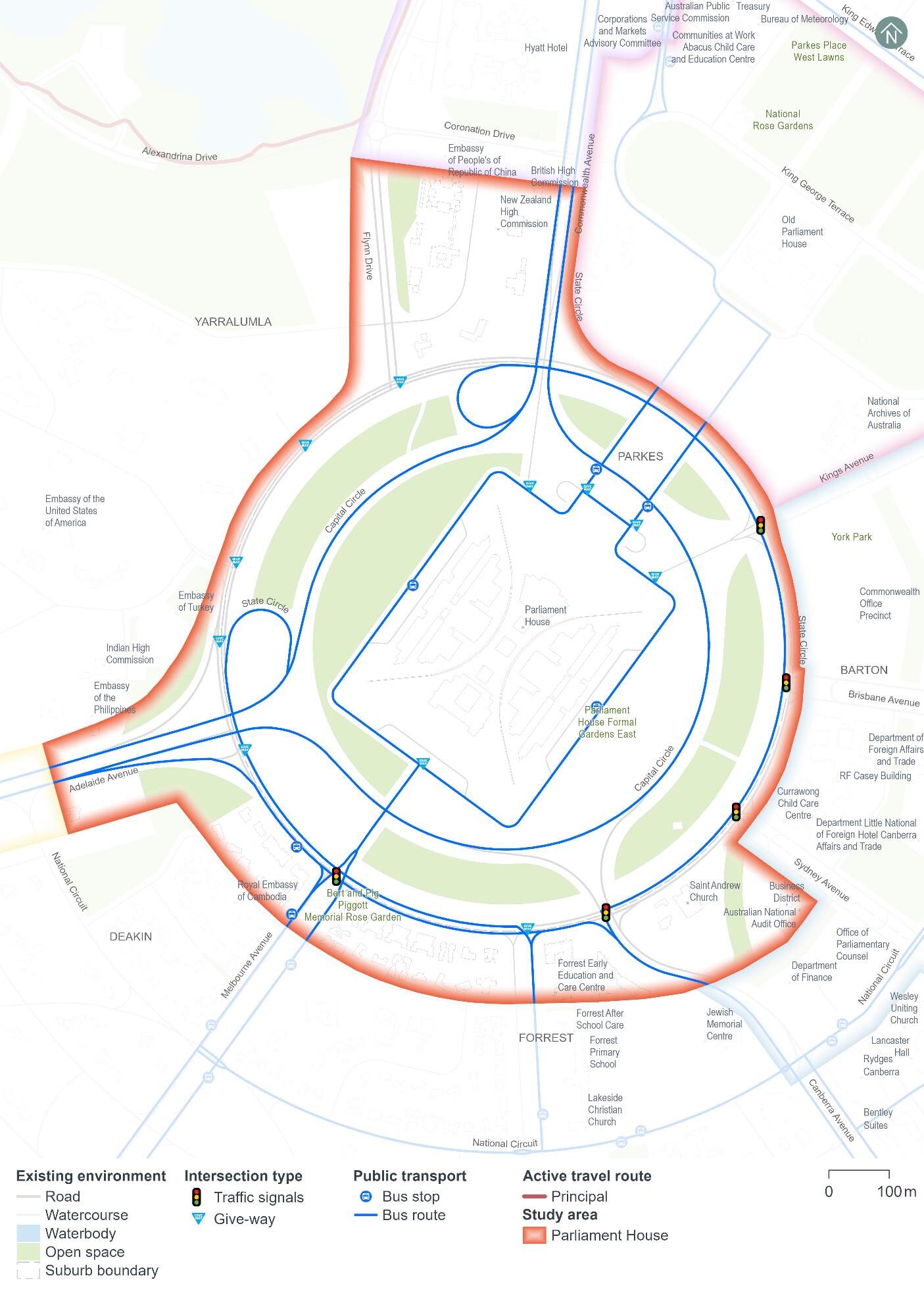
The study area for this assessment is based on the Project area with an additional buffer to incorporate the surrounding road network (the precinct study area). The existing transport network within the Parliament House precinct and the respective study area is indicatively shown on Figure 13-3.
Road network
The characteristics and features of key roads within the Parliament House precinct are summarised in Table 13-1.
| Road | Classification | Direction | Configuration | Speed limit1 |
|---|---|---|---|---|
|
Capital Circle |
Arterial |
One-way in clockwise direction |
Two to three lanes including one T2 transit lane |
80 km/h |
|
Commonwealth Avenue |
Two-way |
Three lanes in each direction, separated by a median |
70 km/h |
|
|
State Circle |
Two-way |
Two lanes in each direction |
70 km/h |
|
|
Kings Avenue |
Two-way |
Two lanes in each direction, separated by 12 m wide median |
60 km/h |
|
|
Brisbane Avenue |
Two-way |
Two lanes in each direction, separated by 30 m wide median |
60 km/h |
|
|
Canberra Avenue |
Two-way |
Two lanes in each direction |
60 km/h |
|
|
Hobart Avenue |
Major collector |
Two-way |
One southbound lane and two northbound lanes, separated by 20 m wide median |
60 km/h |
|
Melbourne Avenue |
Two-way |
Two lanes in each direction, separated by 30 m wide median |
60 km/h |
|
|
Federation Mall |
Minor collector |
Two-way |
One lane in each direction, separated by 90 m |
50 km/h |
|
Parliament Drive |
One-way in anti-clockwise direction |
One to two lanes |
50 km/h |
|
|
Sydney Avenue |
Two-way |
Two lanes in each direction, separated by 30 m wide median |
40 km/h |
Notes:
- Where no speed limit was signposted, the speed limit was assumed to be 50 km/h, the default speed limit for a built-up area.
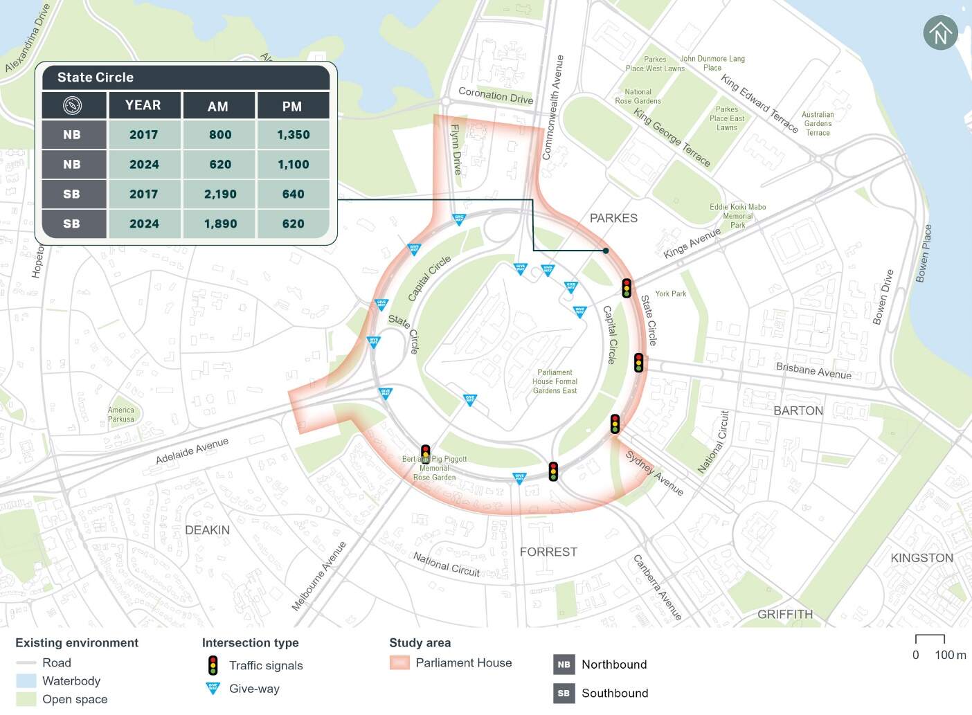
Traffic volumes
Existing 2024 and historical 2017 weekday AM (8:00am to 9:00am) and PM (5:00pm to 6:00pm) peak hour traffic counts for various mid-block locations within the Parliament House precinct have been analysed and are summarised on Figure 13-4. As shown, the 2024 data indicates a reduction in traffic during the AM and PM peak hours along State Circle since 2017. The exception is near Canberra Avenue, where there has been an increase in the eastbound direction during both peak hours, and to the north of Adelaide Avenue, where there has been an increase in the northbound direction in the PM peak hour.
Historical average weekday traffic volume, heavy vehicle composition, and 85th percentile speed data have also been analysed for key roads within the Parliament House precinct, with a summary provided in Table 13-2. The data indicates heavy vehicles account for around 5% to 6% of the total daily traffic volumes on State Circle, while heavy vehicle proportions are lower on Hobart Avenue and Sydney Avenue. Sydney Avenue's 85th percentile vehicle speed is also higher than the posted speed limit.
| Road | Location | Date of available data | Average weekday traffic volume (vehicles per day) | Heavy vehicle % | 85th percentile speed |
|---|---|---|---|---|---|
|
State Circle |
Between Melbourne Avenue and Adelaide Avenue |
2024 |
15,150 |
5% |
66 km/h |
|
State Circle |
Between Sydney Avenue and Canberra Avenue |
2024 |
13,030 |
6% |
70 km/h |
|
Hobart Avenue |
Between Somers Crescent and National Circuit |
2021 |
3,040 |
3% |
55 km/h |
|
Sydney Avenue |
Between State Circle and John McEwan Crescent |
2022 |
5,400 |
4% |
51 km/h |
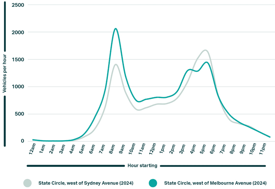
Figure 13-5 shows the weekday average daily traffic volume profile for State Circle, which indicates a clear AM peak hour between 8:00 am and 9:00 am and a PM peak hour between 5:00 pm and 6:00 pm.
Intersection performance
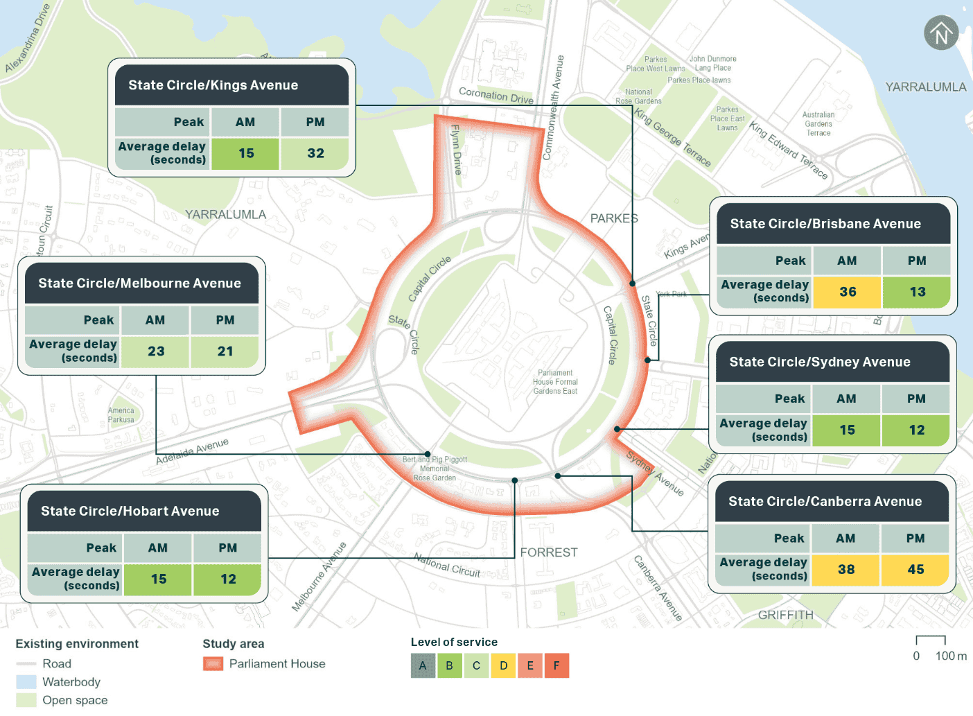
The operation of the key intersections within the Parliament House precinct has been assessed using the microsimulation model which has been calibrated to 2017 traffic conditions and data, as discussed in Chapter 10 (Assessment methodologies). The 2017 intersection performance within the precinct existing performance of the assessed intersections is shown on Figure 13-6.
All the assessed intersections within the Parliament House precinct operated satisfactorily in 2017 at a level of service D or better during the weekday peak hours. Level of service represents the extent of delays experienced by drivers at an intersection. Further detail on intersection performance can be found in Technical Report 1 - Traffic and transport.
Public transport
One existing bus stop is located along State Circle, west of Melbourne Avenue. Only outbound services from the city centre use this bus stop, while inbound services use the bus stop on Melbourne Avenue before turning onto State Circle. In addition, bus stops are located on Parliament Drive adjacent to Parliament House.
Four bus routes service stops within the Parliament House precinct and provide connection to the city centre, Woden Interchange, Barton, Russel Offices, ANU, Canberra Hospital or more regionally to Yass. The bus routes that service stops within the Parliament House study area are routes 57, 58, 59, and 842 (operated by Transport for NSW). In addition, several bus routes also use Capital Circle but do not stop within the Parliament House precinct.
Active travel
Footpaths are provided on both sides of Commonwealth Avenue between Coronation Drive and State Circle and generally along the outer side of State Circle. A network of footpaths is also provided on the inner side of State Circle to provide a connection to Parliament House.
Signalised pedestrian crossings are provided at the following intersections:
- State Circle/Kings Avenue on the north, east and south approaches
- State Circle/Sydney Avenue on the north and east approaches
- State Circle/Canberra Avenue on all approaches
- State Circle/Melbourne Avenue on the west and east approaches.
Zebra crossings are provided on all slip lanes along State Circle's signalised intersections, including the State Circle/Brisbane Avenue intersection, which has no other formal pedestrian crossing facilities.
An on-road cycle lane is provided southbound along Commonwealth Avenue that continues around the eastern side of Capital Circle.
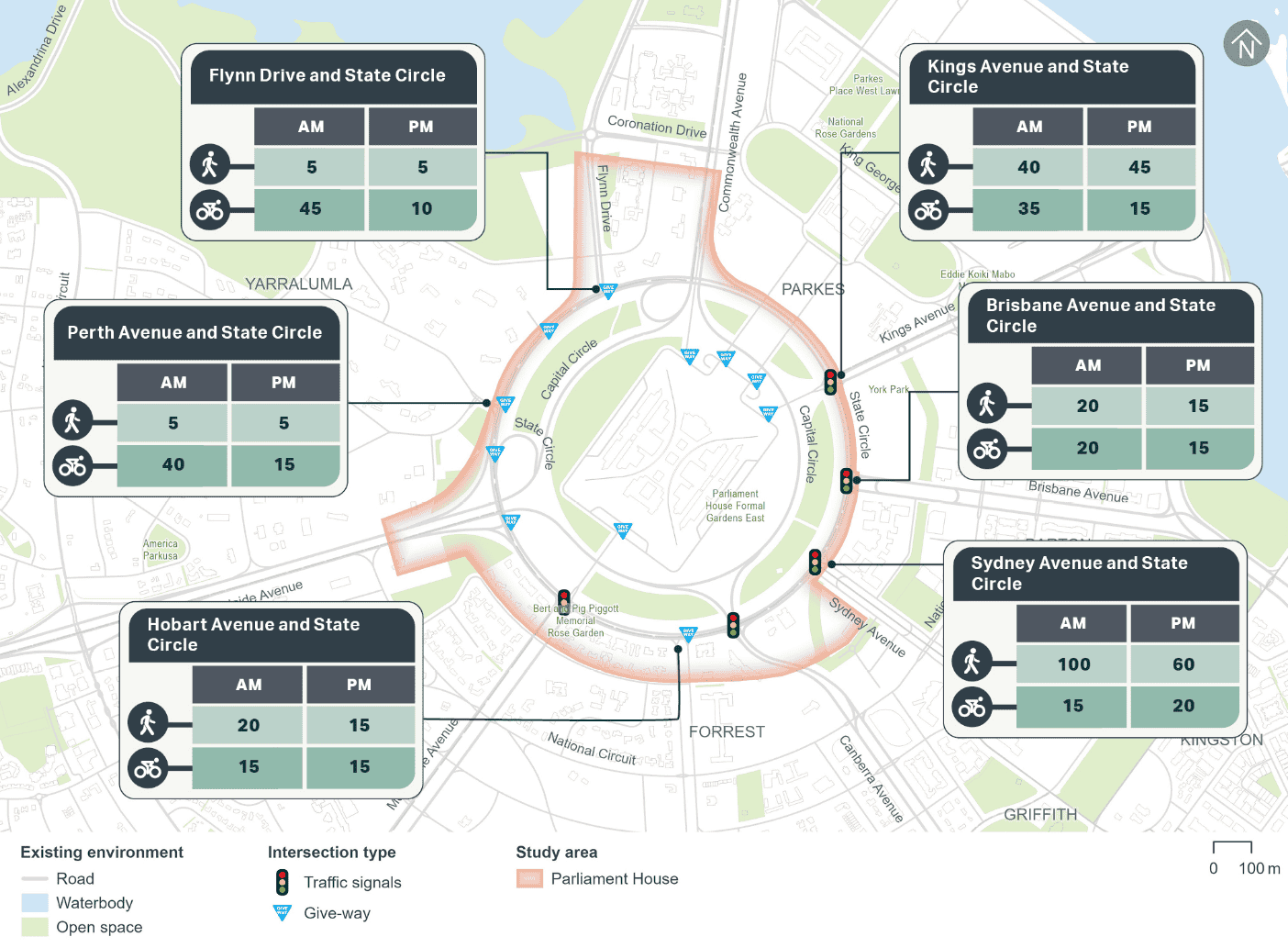
Pedestrian and cyclist count data from 2024 has been used to understand current active travel demand within the Parliament House precinct. The AM and PM peak hour counts at key locations within the precinct are summarised on Figure 13-7. Pedestrian volumes are higher on State Circle East. Cycling demand is higher on State Circle West during the AM peak hour. During the PM peak hour, cycling demand is consistent across all areas of State Circle.
Car parking, kerbside uses, and access
Kerbside uses
The existing kerbside uses including on-street parking within the Parliament House precinct are summarised in Table 13-3.
| On/off alignment | Road | Between | Side of road | Restriction | Number of existing spaces |
|---|---|---|---|---|---|
|
On alignment |
State Circle |
Hobart Avenue and Melbourne Avenue |
South |
2P |
19 |
|
Loading zone (6:00 am - 12:00 pm) |
3 |
||||
|
Melbourne Avenue and Adelaide Avenue |
South |
2P |
9 |
||
|
Bus zone (public) |
N/A |
||||
|
Off alignment |
Hobart Avenue |
State Circle and Somers Crescent |
West |
2P (7:30 am - 6:00 pm Monday to Friday) |
11 |
|
Melbourne Avenue |
State Circle and Somers Crescent |
East |
2P (7:30 am - 6:00 pm Monday to Friday) |
5 |
|
|
West |
Unrestricted |
3 |
|||
|
Bus zone (public) |
N/A |
||||
|
Total |
50 |
||||
Off-street parking
Parliament House has dedicated on-site car parking, which is accessed via Parliament Drive and Federation Mall. Additionally, Scriveners Hut, Federation Mall South West, Federation Mall South East and the Ministerial Wing external car parks have a small number of public and time-restricted car parks.
Property access
There are several property accesses located along the Project's alignment within the Parliament House precinct, as summarised in Table 13-4.
| Road | Site address | Site access arrangement |
|---|---|---|
|
Commonwealth Avenue |
New Zealand High Commission |
Single left in, left out access along Commonwealth Avenue |
|
State Circle |
The Presbyterian Church of St Andrew |
Two separate access points along State Circle |
|
15 State Circle |
Single left in, left out access along State Circle |
|
|
27 State Circle |
Single left in, left out access along State Circle |
|
|
29 State Circle |
Single left in, left out access along State Circle |
|
|
33 State Circle |
Single left in, left out access along State Circle |
|
|
35 State Circle |
Single left in, left out access along State Circle |
Crash history
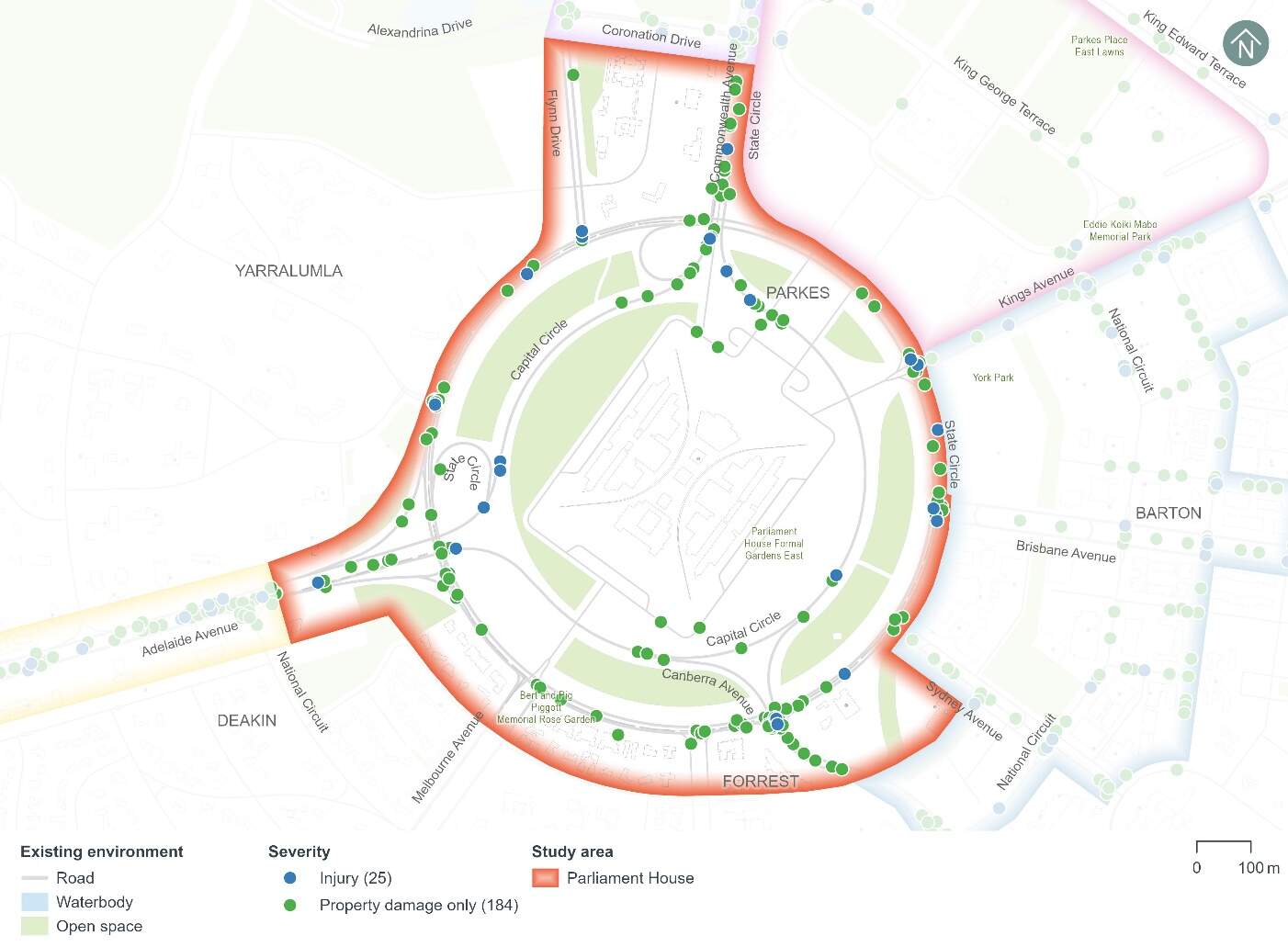
Figure 13-8 shows the five year crash history (1 January 2018 to 31 December 2022) within the Parliament House precinct. A total of 209 crashes have been recorded within the Parliament House precinct during the five year period, including:
- Three crashes that resulted in a serious injury (around 1%)
- 22 crashes that resulted in a minor injury (around 11%)
- 184 crashes that resulted in property damage only (around 88%).
The following common crash types occurred:
- Nearly 31% of crashes involved a rear end collision
- Around 24% of crashes involved a same direction side swipe
- Around 19% of crashes involved an off-road struck object.
Modelling approach
The transport modelling assumptions have adopted the 'committed and funded expenditure approach' as per Infrastructure Australia guidance. This approach was agreed in consultation with Treasury and other key stakeholders including TCCS. The 'committed and funded expenditure approach' requires that only transport projects identified as 'committed and funded' are to be included in the 2031 and 2041 with and without Project scenarios.
As identified in the ACT Infrastructure Plan update - Transport (ACT Government, 2024), project priorities identified beyond the current budget are indicative and may change in response to community preferences, shifts in demand for services and the availability of funding. This means that any projects that might be in planning or may be required to accommodate expected travel demands but have not been identified as 'committed and funded' are not included in the traffic modelling for the Project. This is particularly prevalent in the 2041 scenarios during Project operation.
Based on the transport modelling inputs and assumptions presented above, the transport modelling assesses the impacts of the Project in isolation. It does not consider the broader network benefits that may be realised by the implementation of planned (but not committed and funded) transport infrastructure projects.
By not considering other changes to the transport network, the transport modelling presents an absolute worst-case scenario in relation to the performance of the future road network.
13.2.2 Potential impacts - construction
Potential impacts of the construction of the Project on parking and access within the precinct are summarised in the following sections. Other construction-related impacts have been assessed at a Project-wide basis, where relevant, in Section 11.1.2 of Chapter 11 (Project-wide issues).
Kerbside use
State Circle East alignment option
It is estimated that up to 46 on-street kerbside spaces would be lost within the Project area in the Parliament House precinct, including:
- 31 spaces on State Circle (on-alignment)
- Four spaces on Melbourne Avenue (off-alignment)
- 11 spaces on Hobart Avenue (off-alignment).
This represents around 92% of the total 50 on-street kerbside spaces identified within the Parliament House precinct. Of these kerbside uses, 31 on-street kerbside spaces would be permanently lost as part of the Project's permanent works for the State Circle East alignment option. The remaining spaces would be temporarily lost during construction. However, construction works are likely to be staged, so the temporary loss of on-street kerbside spaces across the precinct may be less at any given time during the construction program.
National Triangle-Barton alignment option
It is estimated that up to 46 on-street kerbside spaces would be temporarily lost within the National Triangle-Barton alignment option Project area in the Parliament House precinct as listed in above in the State Circle East alignment option section. This represents around 92% of the total 50 on-street kerbside spaces identified within the Parliament House precinct.
Construction works are likely to be staged, so the temporary loss of on-street kerbside spaces across the precinct may be less at any given time during the construction program.
Off-street parking
The Project's construction would not change any off-street parking within the Parliament House precinct.
Local area access
State Circle East alignment option
Construction of the State Circle East alignment option would change the following local area access arrangements within the Parliament House precinct:
- Right turns from State Circle to Kings Avenue would be restricted, with the right turn on the southern approach being a temporary restriction only during construction and the right turn on the northern approach being permanently removed as part of the Project
- Right turns from State Circle to Brisbane Avenue would be temporarily restricted
- Right turn from State Circle (eastern approach) to Canberra Avenue (north approach) would be temporarily restricted
- Right turn movements in and out of Hobart Avenue at State Circle would be restricted, noting this is a permanent change as part of the Project.
Vehicles that currently turn right onto Kings Avenue westbound from State Circle southbound would need to access Parliament Drive from Melbourne Avenue or Commonwealth Avenue, or instead approach Kings Avenue via the east or south. Similarly, vehicles that turn right onto Kings Avenue eastbound from State Circle northbound would need to instead approach Kings Avenue from the north or west.
Vehicles that currently turn right from State Circle southbound onto Canberra Avenue/Capital Circle westbound would need to use available alternative routes, such as stay on State Circle to connect with Adelaide Avenue, or adjust their trip further afield to use the broader arterial road network.
Vehicles that currently turn right in or out of Hobart Avenue at State Circle would need to use either Melbourne Avenue or Canberra Avenue along with the connecting streets.
The required local area access diversions would likely result in a slight increase in travel time for impacted motorists including those that may be connecting with Parliament House via Kings Avenue.
Mitigation measures TT3 and TT6 in Chapter 21 (Environmental management and mitigation measures) would address local area access impacts.
National Triangle-Barton alignment option
Right turns from State Circle to Kings Avenue would be temporarily restricted during construction of the National Triangle-Barton alignment option.
Vehicles that currently turn right onto Kings Avenue westbound from State Circle southbound would need to access Parliament Drive from Melbourne Avenue or Commonwealth Avenue, or instead approach Kings Avenue via the east or south. Similarly, vehicles that turn right onto Kings Avenue eastbound from State Circle northbound would need to instead turn right at Brisbane Avenue, or instead approach Kings Avenue from the north or west.
The required local area access diversions would likely result in a slight increase in travel time for impacted motorists including those that may be connecting with Parliament House via Kings Avenue.
Mitigation measures TT3 and TT6 in Chapter 21 (Environmental management and mitigation measures) would address local area access impacts.
Property access
State Circle East alignment option
The two existing site access points on State Circle to the Presbyterian Church of St Andrew would be restricted to left in, left out during construction of the State Circle East alignment option. Vehicles that currently turn right into this site would need to use State Circle and/or other connecting side roads to approach from the north and turn left into the site. Similarly, vehicles that currently turn right out of this site would need to turn left and circulate clockwise around State Circle and/or use connecting side roads to travel north. Approaching these access points from the north rather than the south could result in a slight increase in travel time depending on where drivers are travelling from and how far afield they adjust their travel route. Similarly, departing to the south instead of the north could also result in a slight increase in travel time.
This property access change forms part of the Project's permanent works for the State Circle East alignment option.
Property access at Parliament House would not be impacted by construction of the State Circle East alignment option.
National Triangle-Barton alignment option
Construction of the National Triangle-Barton alignment option would not change property access within the Parliament House precinct, including access to Parliament House itself.
13.2.3 Potential impacts - operation
Potential operational impacts on the road network, active travel and parking of relevance to the precinct are summarised in the following sections. Other operational impacts have been assessed at a Project-wide basis, where relevant, in Section 11.2.2 of Chapter 11 (Project-wide issues).
Road network changes
The road network changes within the Parliament House precinct to accommodate the Project would include speed limit adjustments, adjustments to existing lanes, key intersection adjustments, new intersection arrangements, and adjustments to access arrangements. Refer to Chapter 5 (Project description) for further discussion on road network changes.
Traffic volumes and patterns
Traffic volumes and patterns have been modelled to compare weekday peak hour changes in traffic flow across the Parliament House precinct, particularly on Adelaide Avenue, Capital Circle, and State Circle.
2031 and 2041 were adopted as the future years for the traffic modelling. The years 2031 and 2041 were used to represent indicative future scenarios, providing a benchmark for assessing the potential operational impacts of the Project.
Traffic volume changes associated with the State Circle East alignment option are summarised in Table 13-5 and Table 13-6, and those for the National Triangle-Barton alignment option are summarised in Table 13-7 and Table 13-8. These traffic flow changes are due to the following:
- Regional and local traffic reassignment (when traffic is redistributed as drivers choose alternative routes due to changes in the road network) caused by the Project's road network changes and consequent impacts to road network performance
- Changes in mode choice due to the introduction of light rail.
State Circle East alignment option
| Road | Location | Direction | 2031 scenario | 2041 scenario | ||||||
|---|---|---|---|---|---|---|---|---|---|---|
| Without Project | With Project | Difference | Without Project | With Project | Difference | |||||
|
State Circle |
Between Sydney Avenue and Canberra Avenue |
Eastbound |
1,070 |
970 |
-100 |
-9% |
1,130 |
1,010 |
-120 |
-11% |
|
Westbound |
1,170 |
580 |
-590 |
-50% |
1,070 |
590 |
-480 |
-45% |
||
|
West of Flynn Drive |
Eastbound |
2,280 |
1,440 |
-840 |
-37% |
2,110 |
1,580 |
-530 |
-25% |
|
|
Westbound |
470 |
760 |
290 |
62% |
490 |
750 |
260 |
53% |
||
|
Capital Circle |
Between Canberra Avenue and Melbourne Avenue |
Westbound |
1,670 |
1,150 |
-520 |
-31% |
1,880 |
1,260 |
-620 |
-33% |
|
Between Adelaide Avenue and Commonwealth Avenue |
Northbound |
1,610 |
1,920 |
310 |
19% |
1,370 |
1,580 |
210 |
15% |
|
|
Canberra Avenue |
South of State Circle |
Northbound |
1,350 |
1,240 |
-110 |
-8% |
1,540 |
1,330 |
-210 |
-14% |
|
Southbound |
1,320 |
1,270 |
-50 |
-4% |
1,400 |
1,270 |
-130 |
-9% |
||
|
Hobart Avenue |
South of State Circle |
Northbound |
690 |
520 |
-170 |
-25% |
600 |
440 |
-160 |
-27% |
|
Southbound |
310 |
120 |
-190 |
-61% |
310 |
100 |
-210 |
-68% |
||
| Road | Location | Direction | 2031 scenario | 2041 scenario | ||||||
|---|---|---|---|---|---|---|---|---|---|---|
| Without Project | With Project | Difference | Without Project | With Project | Difference | |||||
|
State Circle |
Between Sydney Avenue and Canberra Avenue |
Eastbound |
650 |
530 |
-120 |
-18% |
610 |
590 |
-20 |
-3% |
|
Westbound |
1,580 |
1,250 |
-330 |
-21% |
1,810 |
1,480 |
-330 |
-18% |
||
|
West of Flynn Drive |
Eastbound |
1,060 |
690 |
-370 |
-35% |
1,170 |
860 |
-310 |
-26% |
|
|
Westbound |
750 |
720 |
-30 |
-4% |
730 |
750 |
20 |
3% |
||
|
Capital Circle |
Between Canberra Avenue and Melbourne Avenue |
Westbound |
2,570 |
2,230 |
-340 |
-13% |
2,480 |
2,440 |
-40 |
-2% |
|
Between Adelaide Avenue and Commonwealth Avenue |
Northbound |
950 |
1,110 |
160 |
17% |
1,190 |
1,060 |
-130 |
-11% |
|
|
Canberra Avenue |
South of State Circle |
Northbound |
1,550 |
1,710 |
160 |
10% |
1,320 |
1,600 |
280 |
21% |
|
Southbound |
1,310 |
1,360 |
50 |
4% |
1,600 |
1,510 |
-90 |
-6% |
||
|
Hobart Avenue |
South of State Circle |
Northbound |
490 |
360 |
-130 |
-27% |
680 |
580 |
-100 |
-15% |
|
Southbound |
500 |
190 |
-310 |
-62% |
540 |
160 |
-380 |
-70% |
||
National Triangle-Barton alignment option
| Road | Location | Direction | 2031 scenario | 2041 scenario | ||||||
|---|---|---|---|---|---|---|---|---|---|---|
| Without Project | With Project | Difference | Without Project | With Project | Difference | |||||
|
State Circle |
Between Sydney Avenue and Canberra Avenue |
Eastbound |
1,070 |
1,020 |
-50 |
-5% |
1,130 |
1,120 |
-10 |
-1% |
|
Westbound |
1,170 |
840 |
-330 |
-28% |
1,070 |
770 |
-300 |
-28% |
||
|
West of Flynn Drive |
Eastbound |
2,280 |
1,910 |
-370 |
-16% |
2,110 |
1,730 |
-380 |
-18% |
|
|
Westbound |
470 |
670 |
200 |
43% |
490 |
660 |
170 |
35% |
||
|
Capital Circle |
Between Canberra Avenue and Melbourne Avenue |
Westbound |
1,670 |
1,350 |
-320 |
-19% |
1,880 |
1,340 |
-540 |
-29% |
|
Between Adelaide Avenue and Commonwealth Avenue |
Northbound |
1,610 |
1,870 |
260 |
16% |
1,370 |
1,590 |
220 |
16% |
|
|
Canberra Avenue |
South of State Circle |
Northbound |
1,350 |
1,350 |
0 |
0% |
1,540 |
1,280 |
-260 |
-17% |
|
Southbound |
1,320 |
900 |
-420 |
-32% |
1,400 |
1,010 |
-390 |
-28% |
||
|
Hobart Avenue |
South of State Circle |
Northbound |
690 |
850 |
160 |
23% |
600 |
730 |
130 |
22% |
|
Southbound |
310 |
320 |
10 |
3% |
310 |
380 |
70 |
23% |
||
| Road | Location | Direction | 2031 scenario | 2041 scenario | ||||||
|---|---|---|---|---|---|---|---|---|---|---|
| Without Project | With Project | Difference | Without Project | With Project | Difference | |||||
|
State Circle |
Between Sydney Avenue and Canberra Avenue |
Eastbound |
650 |
380 |
-270 |
-42% |
610 |
730 |
120 |
20% |
|
Westbound |
1,580 |
1,500 |
-80 |
-5% |
1,810 |
1,540 |
-270 |
-15% |
||
|
West of Flynn Drive |
Eastbound |
1,060 |
1,090 |
30 |
3% |
1,170 |
1,400 |
230 |
20% |
|
|
Westbound |
750 |
1,020 |
270 |
36% |
730 |
1,030 |
300 |
41% |
||
|
Capital Circle |
Between Canberra Avenue and Melbourne Avenue |
Westbound |
2,570 |
2,580 |
10 |
0% |
2,480 |
2,300 |
-180 |
-7% |
|
Between Adelaide Avenue and Commonwealth Avenue |
Northbound |
950 |
900 |
-50 |
-5% |
1,190 |
890 |
-300 |
-25% |
|
|
Canberra Avenue |
South of State Circle |
Northbound |
1,550 |
1,620 |
70 |
5% |
1,320 |
1,750 |
430 |
33% |
|
Southbound |
1,310 |
1,560 |
250 |
19% |
1,600 |
1,330 |
-270 |
-17% |
||
|
Hobart Avenue |
South of State Circle |
Northbound |
490 |
420 |
-70 |
-14% |
680 |
580 |
-100 |
-15% |
|
Southbound |
500 |
390 |
-110 |
-22% |
540 |
600 |
60 |
11% |
||
Road network performance
State Circle East alignment option
A comparison of vehicle delay across the Parliament House precinct's road network with and without the Project in the 2031 scenario has been conducted for the AM and PM peak hours.
Within the Parliament House precinct, there would be localised areas where higher congestion levels would occur in both the with and without Project scenarios in the AM and PM peak hours in both 2031 and 2041, such as on the approaches to intersections.
The Project's changes to the road network and associated traffic reassignment and signal operation changes would cause the following changes to congestion and vehicle delay when compared to the without Project scenario in 2031:
- Increased congestion and delay on State Circle (clockwise direction) and, particularly on approach to Kings Avenue and propagating back to Adelaide Avenue, as well as Brisbane Avenue and Melbourne Avenue during the AM peak hour
- Increased congestion and delay on State Circle (clockwise direction) on approach to Melbourne Avenue during the PM peak hour and decreased congestion and delay on approach to Canberra Avenue and Kings Avenue during the PM peak hour
- Increased congestion and delay on State Circle (anti-clockwise direction) on approach to Canberra Avenue during the AM peak hour and on approach to Brisbane Avenue during the PM peak hour
- Decreased congestion and delay on State Circle (anti-clockwise direction) on approach to Perth Avenue during the PM peak hour
- Increased congestion and delay on Melbourne Avenue at the northern approach to State Circle during the PM peak hour
- Decreased congestion and delay on Adelaide Avenue westbound on-ramp near State Circle during the PM peak hour
- Increased congestion and delay on Capital Circle between Adelaide Avenue and Commonwealth Avenue during the AM and PM peak hours
- Decreased congestion and delay on Flynn Drive on the approach to State Circle during the AM peak hour, which could be due to more gaps in the traffic stream on State Circle due to reduced vehicle speeds because of a more congested network
- Decreased congestion and delay on the Capital Circle off-ramp to Canberra Avenue during the AM peak hour and increased congestion and delay on Capital Circle off-ramp to Canberra Avenue during the PM peak hour.
With the Project, traffic flows on some sections of State Circle in the clockwise direction and the Capital Circle off-ramp to Canberra Avenue would reduce during the AM and PM peak hours, respectively. However, congestion on these sections would increase due to changes in signal operations resulting from the altered traffic flows.
Similar changes to network congestion and vehicle delays would occur during the AM and PM peak hours in 2041. However, the extent of longer delays is anticipated to propagate further than in 2031.
National Triangle-Barton alignment option
A comparison of vehicle delay across the Parliament House precinct's road network with and without the Project in the 2031 scenario has been conducted for the AM and PM peak hours.
Within the Parliament House precinct, there would be localised areas where higher congestion levels would occur in both the with and without Project scenarios in the AM and PM peak hours in both 2031 and 2041, such as on the approaches to intersections.
The Project's changes to the road network and associated traffic reassignment and signal operation changes would cause the following changes to congestion and vehicle delay when compared to the without Project scenario in the 2031 scenario:
- Increased congestion and delay on Commonwealth Avenue on the southbound approach to Capital Circle and propagating back to Coronation Drive during the AM peak hour
- Increased congestion and delay on State Circle (clockwise direction) on approach to Kings Avenue and propagating back to Perth Avenue and on approach to Canberra Avenue and propagating back to Brisbane Avenue during the AM peak hour
- Increased congestion and delay on State Circle (anti-clockwise direction) on approach to Brisbane Avenue and propagating back to Melbourne Avenue during the AM peak hour
- Decreased congestion and delay on Perth Avenue on approach to State Circle during the AM peak hour
- Increased congestion and delay on the Capital Circle off-ramp to Canberra Avenue and propagating back to Commonwealth Avenue during the AM peak hour and decreased congestion and delay during the PM peak hour
- Increased congestion and delay on Adelaide Avenue in the westbound direction during the PM peak hour
- Increased congestion and delay on State Circle (clockwise direction) on the approach to Sydney Avenue and decreased congestion and delay on the approach to Canberra Avenue during the PM peak hour
- Decreased congestion and delay on State Circle (anti-clockwise direction) on the approach to Perth Avenue during the PM peak hour
- Decreased congestion and delay on the State Circle off-ramp onto Commonwealth Avenue northbound and on Commonwealth Avenue northbound during the PM peak hour
- Decreased congestion and delay on Flynn Drive on the approach to State Circle during the AM peak hour, which could be due to more gaps in the traffic stream on State Circle due to reduced vehicle speeds because of a more congested network.
With the Project, traffic flows on some sections of State Circle in the clockwise direction would reduce during the AM and PM peak hours, respectively. However, congestion on these sections would increase due to changes in signal operations resulting from the altered traffic flows.
Similar changes to network congestion and vehicle delays would occur during the AM and PM peak hours in the 2041 scenario. Although, the extent of longer delays is anticipated to propagate further than in the 2031 scenario.
Intersection performance
State Circle East alignment option
The performance of the key intersections within the Parliament House precinct with and without the Project for the State Circle East alignment option is provided in Table 13-9 and Table 13-10. Intersection performance is evaluated using the level of service and average delay assessed for each intersection. Level of service represents the extent of delays experienced by drivers at an intersection. Further detail on intersection performance can be found in Technical Report 1 - Traffic and transport. Key findings relating to intersection performance are as follows:
AM peak hour:
- The State Circle/Hobart Avenue intersection and new Project alignment crossings across State Circle (south) and Capital Circle would operate satisfactorily at a level of service A with the Project in the 2031 and 2041 scenarios. The improved performance at the State Circle/Hobart Avenue intersection with the Project is due to the intersection arrangement changing to permit left in, and left out movements only
- The performance of other intersections along State Circle would generally reduce with the Project in 2031 and 2041 scenarios. This reduction in intersection performance would be due to the introduction of the Project alignment and associated signal phasing changes, along with the removal of several slip lanes, which would result in left turning vehicles being controlled by traffic signals. In addition, the removal of a right turn at the State Circle/Kings Avenue intersection would result in higher vehicle delays at adjacent intersections where the right turn movement would be retained.
PM peak hour:
- The following intersections would operate satisfactorily at a level of service D or better with the Project in 2031 and 2041 scenarios:
- Light rail crossing of State Circle (north)
- Brisbane Avenue/State Circle
- Sydney Avenue/State Circle
- Hobart Avenue/State Circle
- Light rail crossing of State Circle (south)
- Light rail crossing of Capital Circle.
- The performance of other intersections along State Circle would generally reduce with the Project in 2031 and 2041 scenarios during the PM peak hour, similar to the AM peak hour.
| Intersection | 2031 scenario | 2041 scenario | ||||||
|---|---|---|---|---|---|---|---|---|
| Without Project | With Project | Without Project | With Project | |||||
|
Average delay (seconds) |
Level of service |
Average delay (seconds) |
Level of service |
Average delay (seconds) |
Level of service |
Average delay (seconds) |
Level of service |
|
|
Light rail crossing of State Circle (north) |
- |
- |
123 |
F |
- |
- |
108 |
F |
|
Kings Avenue/State Circle |
82 |
F |
104 |
F |
35 |
C |
115 |
F |
|
Brisbane Avenue/ State Circle |
24 |
C |
54 |
D |
23 |
C |
86 |
F |
|
Sydney Avenue/ State Circle/ |
37 |
D |
56 |
E |
32 |
C |
75 |
E |
|
Canberra Avenue/ State Circle |
61 |
E |
66 |
E |
87 |
F |
86 |
F |
|
Hobart Avenue/ State Circle |
11 |
B |
2 |
A |
71 |
E |
2 |
A |
|
Melbourne Avenue/State Circle |
29 |
C |
65 |
E |
42 |
D |
62 |
E |
|
Light rail crossing of State Circle (south) |
- |
- |
10 |
A |
- |
- |
33 |
C |
|
Light rail crossing of Capital Circle |
- |
- |
7 |
A |
- |
- |
6 |
A |
Note: As discussed in Technical Report 1 - Traffic and transport, separate VISSIM microsimulation models have been used to assess the State Circle East and National Triangle-Barton alignment options which may result in small intersection performance differences between the without Project scenarios for each alignment option.
| Intersection | 2031 scenario | 2041 scenario | ||||||
|---|---|---|---|---|---|---|---|---|
| Without Project | With Project | Without Project | With Project | |||||
|
Average delay (seconds) |
Level of service |
Average delay (seconds) |
Level of service |
Average delay (seconds) |
Level of service |
Average delay (seconds) |
Level of service |
|
|
Light rail crossing of State Circle (north) |
- |
- |
36 |
D |
- |
- |
37 |
D |
|
Kings Avenue/State Circle |
49 |
D |
74 |
E |
36 |
D |
81 |
F |
|
Brisbane Avenue/ State Circle |
26 |
C |
28 |
C |
28 |
C |
33 |
C |
|
Sydney Avenue/ State Circle/ |
39 |
D |
46 |
D |
61 |
E |
55 |
D |
|
Canberra Avenue/ State Circle |
143 |
F |
78 |
E |
134 |
F |
128 |
F |
|
Hobart Avenue/ State Circle |
24 |
C |
9 |
A |
110 |
F |
4 |
A |
|
Melbourne Avenue/State Circle |
29 |
C |
65 |
E |
49 |
D |
59 |
E |
|
Light rail crossing of State Circle (south) |
- |
- |
8 |
A |
- |
- |
9 |
A |
|
Light rail crossing of Capital Circle |
- |
- |
6 |
A |
- |
- |
5 |
A |
Note: As discussed in Technical Report 1 - Traffic and transport, separate VISSIM microsimulation models have been used to assess the State Circle East and National Triangle-Barton alignment options which may result in small intersection performance differences between the without Project scenarios for each alignment option.
National Triangle-Barton alignment option
The performance of the key intersections within the Parliament House precinct with and without the Project for the National Triangle-Barton alignment option is provided in Table 13-11 and Table 13-12 Key findings relating to intersection performance are as follows:
AM peak hour:
- The following intersections would operate satisfactorily at a level of service D or better with the Project in 2031 and 2041 scenarios:
- State Circle/Melbourne Avenue
- State Circle/Hobart Avenue
- Light rail crossing of Capital Circle
- There is an improvement in performance at the State Circle/Hobart Avenue intersection in the 2041 scenario with the Project (level of service D versus F without the Project). This is due to the storage capacity for the right turn from State Circle to Hobart Avenue being increased
- The performance of the State Circle/Sydney Avenue intersection would reduce with the Project in 2031 and 2041 scenarios. This reduction in intersection performance is due to the Project alignment passing through this intersection and associated signal phasing changes. In addition, the removal of a U-turn movement within the central median on Sydney Avenue would shift this demand to the State Circle/Sydney Avenue intersection, where this U-turn movement would be permitted with the Project
- Similarly, the performance of the State Circle/Canberra Avenue intersection would reduce in the 2031 scenario due to the Project alignment passing through this intersection and associated signal phasing changes. However, the additional short lane on Canberra Avenue (refer to Chapter 5 (Project description) for discussion on road network changes) and the change in travel patterns with the Project results in a slightly lower delay across the intersection in the 2041 scenario compared to without the Project.
PM peak hour:
- The following intersections would operate satisfactorily at a level of service D or better with the Project in 2031 and 2041 scenarios:
- State Circle/Hobart Avenue
- State Circle/Melbourne Avenue
- Light rail crossing of Capital Circle
- The performance of the State Circle/Sydney Avenue intersection would reduce with the Project in 2031 and 2041 scenarios due to the introduction of the Project alignment and associated signal phasing changes
- The performance of the State Circle/Canberra Avenue intersection would improve with the Project in 2031 and 2041 scenarios due to the additional lane on Canberra Avenue and change in travel patterns with the Project.
| Intersection | 2031 scenario | 2041 scenario | ||||||
|---|---|---|---|---|---|---|---|---|
| Without Project | With Project | Without Project | With Project | |||||
|
Average delay (seconds) |
Level of service |
Average delay (seconds) |
Level of service |
Average delay (seconds) |
Level of service |
Average delay (seconds) |
Level of service |
|
|
Sydney Avenue/ State Circle/ |
33 |
C |
77 |
E |
41 |
D |
76 |
E |
|
Canberra Avenue/ State Circle |
54 |
D |
63 |
E |
76 |
E |
64 |
E |
|
State Circle/ Hobart Avenue |
11 |
B |
32 |
C |
>150 |
F |
37 |
D |
|
State Circle/ Melbourne Avenue |
28 |
C |
46 |
D |
49 |
D |
54 |
D |
|
Light rail crossing of Capital Circle |
- |
- |
7 |
A |
- |
- |
7 |
A |
Note: As discussed in Technical Report 1 - Traffic and transport, separate VISSIM microsimulation models have been used to assess the State Circle East and National Triangle-Barton alignment options which may result in small intersection performance differences between the without Project scenarios for each alignment option.
| Intersection | 2031 scenario | 2041 scenario | ||||||
|---|---|---|---|---|---|---|---|---|
| Without Project | With Project | Without Project | With Project | |||||
|
Average delay (seconds) |
Level of service |
Average delay (seconds) |
Level of service |
Average delay (seconds) |
Level of service |
Average delay (seconds) |
Level of service |
|
|
Sydney Avenue/ State Circle/ |
51 |
D |
64 |
E |
52 |
D |
65 |
E |
|
Canberra Avenue/ State Circle |
120 |
F |
80 |
E |
113 |
F |
75 |
E |
|
State Circle/ Hobart Avenue |
22 |
C |
12 |
B |
128 |
F |
33 |
C |
|
State Circle/ Melbourne Avenue |
28 |
C |
47 |
D |
50 |
D |
41 |
D |
|
Light rail crossing of Capital Circle |
- |
- |
5 |
A |
- |
- |
5 |
A |
Note: As discussed in Technical Report 1 - Traffic and transport, separate VISSIM microsimulation models have been used to assess the State Circle East and National Triangle-Barton alignment options which may result in small intersection performance differences between the without Project scenarios for each alignment option.
Active travel
State Circle East alignment option
The key active travel provisions that would be provided within the Parliament House precinct as part of the Project for the State Circle East alignment option and their benefits or impacts are summarised in Table 13-13.
| Proposed treatment | Impact or benefit |
|---|---|
|
Slip lanes would be removed at the following intersections to signalise the pedestrian crossing:
|
The signalised pedestrian crossings would provide a controlled and typically safer crossing facility. However, providing signalised pedestrian crossings could result in increased delays for pedestrians waiting to cross the road. |
|
Signalised pedestrian crossings would be provided across the tracks at the following locations:
|
The signalised pedestrian crossings would be staged crossings which could result in higher delays for pedestrians waiting to cross the road than the current signalised crossings in these locations. |
|
A signalised pedestrian crossing would be provided on the slip lane from Commonwealth Avenue to State Circle. |
A signalised pedestrian crossing would provide a controlled and typically safer crossing facility. However, providing a signalised pedestrian crossing could result in higher delays for pedestrians waiting to cross the road. |
|
Pedestrian track connection would be provided between Capital Circle and State Circle west of Melbourne Avenue and would be an unsignalised but formalised crossing of the track. |
Existing pedestrian and cyclist connectivity would be maintained across the track. |
National Triangle-Barton alignment option
The key active travel provisions that would be provided within the Parliament House precinct as part of the Project for the National Triangle-Barton alignment option and their benefits or impacts are summarised in Table 13-14.
| Proposed treatment | Impact or benefit |
|---|---|
|
Signalised pedestrian crossings would be provided across the tracks at the following locations:
|
The signalised pedestrian crossings would be staged crossings which could result in higher delays for pedestrians waiting to cross the road than the current signalised crossings in these locations. |
|
Pedestrian track connection would be provided between Capital Circle and State Circle west of Melbourne Avenue and would be an unsignalised but formalised crossing of the track. |
Existing pedestrian and cyclist connectivity would be maintained across the track. |
Kerbside use
State Circle East alignment option
The State Circle East alignment option would remove 31 on-street kerbside spaces along State Circle between Hobart Avenue and Adelaide Avenue within the Parliament House precinct. Historical aerial imagery and site observations from June 2024 indicate that these spaces are currently not well utilised. Kerbside parking demand on adjacent side roads such as Hobart Avenue and Melbourne Avenue is also low. As such, it is likely these side roads could accommodate some of the existing demand for the kerbside uses on State Circle that would be removed as part of the Project.
National Triangle-Barton alignment option
The National Triangle-Barton alignment option would not change any kerbside uses within the Parliament House precinct.
Off-street parking
The Project would not change any off-street parking within the Parliament House precinct.
Local area access
State Circle East alignment option
The State Circle East alignment option would change the following local area access arrangements within the Parliament House precinct:
- Right turn from State Circle southbound to Kings Avenue westbound would be removed
- Right turn movements in and out of Hobart Avenue at State Circle would be removed.
Vehicles that currently turn right onto Kings Avenue westbound from State Circle southbound would need to access Parliament Drive from Melbourne Avenue or Commonwealth Avenue, or instead approach Kings Avenue via the east or south.
Vehicles that currently turn right in or out of Hobart Avenue at State Circle would need to use either Melbourne Avenue or Canberra Avenue along with the connecting streets.
These changes to local area access would likely result in a slight increase in travel time, including to vehicles that may be connecting with Parliament House via Kings Avenue, depending on where drivers are travelling to/from and how far afield they adjust their travel route.
National Triangle-Barton alignment option
U-turns out of Sydney Avenue onto State Circle and returning into Sydney Avenue would be enabled to offset the removal of the existing U-turn movement that uses the central median on Sydney Avenue. The National Triangle-Barton alignment option would not change any other local area access arrangements within the Parliament House precinct.
Property access
State Circle East alignment option
The State Circle East alignment option would realign the kerb of Commonwealth Avenue outside the New Zealand High Commission, resulting in minor adjustments to the existing property access kerbs. However, the kerb realignment would not alter the functionality of existing access.
The two existing site access points on State Circle to the Presbyterian Church of St Andrew would be restricted to left in, left out with the State Circle East alignment option. Vehicles that currently turn right into this site would need to use State Circle and/or other connecting side roads to approach from the north and turn left into the site. Similarly, vehicles that currently turn right out of this site would need to turn left and circulate clockwise around State Circle and/or use connecting side roads to travel north. Approaching these access points from the north rather than the south could result in a slight increase in travel time depending on where drivers are travelling from and how far afield they adjust their travel route. Similarly, departing to the south instead of the north could also result in a slight increase in travel time.
Property access at Parliament House would not be impacted by the Project.
National Triangle-Barton alignment option
The National Triangle-Barton alignment option would not change any property accesses within the Parliament House precinct, including access to Parliament House itself.
13.2.4 Precinct specific management and mitigation measures
Environmental management for this Project is detailed in Chapter 21 (Environmental management and mitigation measures). This includes construction and operational mitigation measures to manage traffic and transport impacts, that are applicable to the Project as a whole.
No further precinct-specific measures have been identified for traffic and transport impacts at the Parliament House precinct.
13.3 Noise and vibration
This section provides an assessment of the potential noise and vibration impacts associated with the construction and operation of the Project within the Parliament House precinct. Further detail on the noise and vibration impact assessment is provided in Technical Report 9 - Noise and vibration. The methodology applied for this assessment is summarised in Chapter 10 (Assessment methodologies) and discussed in detail in Section 4 of Technical Report 9 - Noise and vibration.
13.3.1 Existing environment
Sensitive receivers and noise catchment area
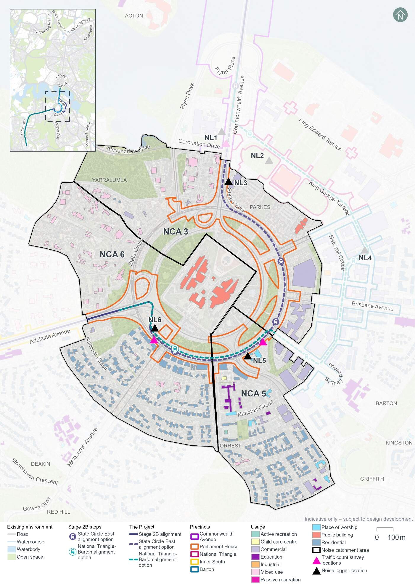
Noise Catchment Areas were determined based on the general ambient noise environment of the area, and the types of receivers and land uses potentially affected by the Project. Noise Catchment Areas 3, 5, and 6 were identified for the noise assessment of the Parliament House precinct. Noise Catchment Areas 3, 5 and 6 and associated sensitive receivers are shown on Figure 13-9.
Noise Catchment Area 3 consists mainly of mixed use (embassies and high commissions) and commercial land uses, including federal government offices in the RG Casey Building, located on John McEwen Crescent in Barton. There are two heritage-listed items within Noise Catchment Area 3 - West Block and Dugout and East Block Government Offices, both listed under the Commonwealth Heritage List. The National Archives of Australia is located within East Block, and is considered a receiver that may have potentially vibration-sensitive equipment. Further detail on the West Block and Dugout is included in Section 13.5 and discussion regarding the East Block Government Offices is included in Section 14.5, given its proximity to the National Triangle precinct.
Noise Catchment Area 5 is centred in the suburb of Forrest and includes several residential apartments and houses, particularly in the southern portion of the catchment area. There are a number of commercial and educational land uses, including offices along Sydney Avenue and Forrest Primary School. There are also several places of worship, such as the Presbyterian Church of Saint Andrew, Lakeside Christian Church, and Saint Christopher's Cathedral.
The predominant feature within Noise Catchment Area 6 is the public building land use feature of Parliament House. Within Noise Catchment Area 6, Parliament House is surrounded by mixed use land uses to the west (mostly including embassies and high commissions), and by residential land uses to the south.
Existing noise levels
Unattended noise monitoring was carried out at three locations in the Parliament House precinct (at noise loggers 3, 5 and 6 (NL3, NL5 and NL6)) between 2 and 15 May 2024, to provide a representation of existing background noise levels. The results of this monitoring are summarised in Table 13-15. The LA90 level is the noise level exceeded for 90% of the sample period, and the LAeq level is the energy averaged noise level over the 15-minute period.
| Location ID | Noise logger address | Rating background level (LA90), dB(A)1 | Ambient noise level (LAeq), dB(A)1 | ||
|---|---|---|---|---|---|
|
Day2 |
Night2 |
Day2 |
Night2 |
||
|
NL3 |
West Block, Queen Victoria Terrace, Parkes |
53 |
303 |
66 |
59 |
|
NL5 |
The Presbyterian Church of Saint Andrew, 3 State Circle, Forrest |
53 |
32 |
64 |
55 |
|
NL6 |
Opposite 29 State Circle, Deakin |
52 |
303 |
59 |
51 |
Notes:
- dB(A) represents A-weighted decibels, the relative frequency response used in sound measuring instruments.
- In accordance with the NSW Noise Policy for Industry (NSW Environment Protection Authority, 2017) time of day is defined as follows:
- Day - the period from 7 am to 6 pm Monday to Saturday or 8 am to 6 pm on Sundays and public holidays.
- Night - 10 pm to 7 am (Monday to Saturday); 10 pm to 8 am (Sundays and public holidays)
- Evening (not included in table) - the period from 6 pm to 10 pm.
Attended noise measurements were also carried out at each unattended monitoring location on 1 May 2024 during the daytime period. The results of this monitoring are summarised in Table 13-16.
| Location ID | LAeq dB(A) | LA90 dB(A) | Comments |
|---|---|---|---|
|
NL3 |
64 |
53 |
Noise recorded was dominated by traffic, including trucks and cars. Some insect noise was audible during lulls in traffic, and some construction noise from West Block was audible. |
|
NL5 |
60 |
53 |
Noise recorded was dominated by traffic noise from the intersection. Some bird noise was audible during lulls. |
|
NL6 |
62 |
51 |
Noise recorded reflected mostly constant traffic. |
Road traffic noise monitoring was also carried out at NL5 and NL6, with data used to validate a road traffic noise model for the Project. The results of this monitoring are summarised in Section 2.5 of Technical Report 9 - Noise and vibration.
13.3.2 Potential impacts - construction
The following sections present construction noise and vibration assessment results without the application of mitigation measures (referred to as unmitigated). Measures in Chapter 21 (Environmental management and mitigation measures) and Appendix L (Environmental Management Plan outline) would be implemented to manage these potential impacts. With the application of these mitigation measures it is expected that the unmitigated impacts would be noticeably reduced or, in some cases, avoided altogether.
Construction noise
Approach
In accordance with Section 29 and Item 16 of Schedule 2 Table 2.3 of the ACT Environment Protection Regulation 2005, construction of light rail or major roads do not require noise to be assessed against specific numerical noise limits as they are not taken to cause environmental harm. Item 16 of Table 2.3 places no conditions on the “Noise emitted in the course of constructing or maintaining a major road, a dedicated bus way, a railway or light rail.” Section 9.11 of the Environment Protection (Noise) Environment Protection Policy 2010 provides the following reasoning for the exemption of roadworks, noting that “the construction and maintenance of roads is central to the economic and social well-being of the community.”
In the absence of Territory specific quantifiable criteria, the NSW Interim Construction Noise Guideline (NSW Department of Environment and Climate Change, 2009) has been used to guide this assessment, as the Project would be of a large scale and occur within a relatively close proximity to noise sensitive receivers.
While construction noise generated by the Project is not required to be assessed against specific numerical noise limits, the derived assessment levels used in this EIS provide an indication of potential noise impacts to assist in the identification of appropriate mitigation measures, and were based on the NSW Interim Construction Noise Guideline (NSW Department of Environment and Climate Change, 2009).
The construction noise assessment presents a worst-case assessment which adopts conservative assumptions. For example, the noise model has used the shortest separation distance between worksites and each sensitive receiver, and has assumed the noisiest equipment would be in use. Actual construction noise levels experienced by receivers would generally be lower than the construction noise predictions. Modelling assumptions are discussed further in Technical Report 9 - Noise and vibration.
Scenarios
The noise assessment considers noise impacts from concurrent construction work across multiple precincts, but the results are reported at a precinct level.
The following construction scenarios have been modelled as a part of the noise and vibration impact assessment for the Parliament House precinct:
- Mobilisation and establishment of construction compound sites
- Protection, relocation, treatment and/or decommissioning of utilities
- Earthworks, road works and construction of light rail infrastructure (which includes construction of the covered section on Commonwealth Avenue and State Circle for the State Circle East alignment option using equipment such as hammers and excavators)
- Construction of stops
- Construction of bridges on land.
Finishing works, including rectification of any defects, would be carried out progressively during construction and have been considered in the assessment of each scenario described above. Testing and commissioning works are not expected to entail any additional noise and vibration impact beyond the standard operation of the Project, therefore a quantitative assessment has not been undertaken.
Construction activities for the Project would be undertaken between the hours of 7am and 6pm Monday to Saturday (standard construction hours), as far as practicable. As outlined in Section 6.5 of Chapter 6 (Construction), some work would likely be required outside of standard construction hours to minimise disruptions to traffic, minimise disturbance to surrounding landowners and businesses, and/or maintain safe and efficient operation of key roads and public transport facilities. Work proposed outside of standard construction hours would require assessment and approval on a case-by-case basis, as outlined in mitigation measure NV3 in Chapter 21 (Environmental management and mitigation measures).All construction scenarios have been assessed based on work occurring during standard construction hours and during out of standard hours periods, with the exception of mobilisation and establishment of construction compound sites, which was only assessed as occurring during standard construction hours.
Construction noise scenarios have been categorised into 'peak' and 'typical' works to represent the likely range of potential noise impacts. 'Peak' works represent the noisiest works which require the use of noise intensive equipment such as concrete saws and rock breakers, while 'typical' works represent typical noise emissions from a construction scenario when noise intensive equipment is not in use. Consequently, the 'typical' scenarios would result in a reduced number of noise exceedances compared to 'peak' scenarios. Where possible, peak works and other high noise generating works would be carried out during standard construction hours. Should high noise impact activities be required to be undertaken outside of standard construction hours, they would be subject to specific controls identified in mitigation measures NV3 and NV4 (refer to Chapter 21 (Environmental management and mitigation measures)).
Where relevant, construction scenarios have been assessed separately for each alignment option to reflect the different locations of proposed work.
Assessment results
The number of residential buildings where receivers are predicted to be moderately or highly noise affected is shown in Table 13-17, which assumes no mitigation measures are in place. The number of buildings where noise levels are predicted to result in moderately affected receivers are separated into day and night-time periods, as appropriate.
The number of non-residential buildings predicted to be moderately noise affected is shown in Table 13-18.
Construction noise modelling has been completed assuming the noisiest equipment would be in use on the boundary of the Project area footprint, allowing for a worst-case scenario to be assessed. Section 3.2 of Technical Paper 9 - Noise and vibration provides further detail on the assessment approach.
| Construction scenario | Construction work category | Predicted noise affected buildings1 (unmitigated) | ||
|---|---|---|---|---|
| Standard construction hours - moderately noise affected | Outside of standard construction hours (night-time) - moderately noise affected | Highly noise affected2 | ||
|
Noise Catchment Area 3 |
||||
|
Mobilisation and establishment of construction compound sites |
Peak |
- |
N/A |
1 |
|
Typical |
- |
N/A |
- |
|
|
Protection, relocation, treatment and/or decommissioning of utilities |
Peak |
3 |
20 |
8 |
|
Typical |
- |
14 |
2 |
|
|
Earthworks, road works, and construction of light rail infrastructure |
Peak |
4 |
20 |
7 |
|
Typical |
2 |
17 |
5 |
|
|
Earthworks, road works, and construction of light rail infrastructure |
Peak |
1 |
14 |
1 |
|
Typical |
1 |
8 |
1 |
|
|
Construction of stops (State Circle East alignment option) |
Typical/peak |
- |
- |
- |
|
Construction of stops (National Triangle-Barton alignment option) |
Typical/peak |
- |
- |
- |
|
Construction of bridges on land |
Peak |
- |
2 |
- |
|
Typical |
- |
- |
- |
|
|
Noise Catchment Area 5 |
||||
|
Mobilisation and establishment of construction compound sites |
Peak |
- |
N/A |
- |
|
Typical |
- |
N/A |
- |
|
|
Protection, relocation, treatment and/or decommissioning of utilities |
Peak |
2 |
14 |
3 |
|
Typical |
2 |
3 |
2 |
|
|
Earthworks, road works, and construction of light rail infrastructure |
Peak |
2 |
5 |
3 |
|
Typical |
2 |
3 |
2 |
|
|
Earthworks, road works, and construction of light rail infrastructure |
Peak |
2 |
5 |
3 |
|
Typical |
2 |
3 |
2 |
|
|
Construction of stops (State Circle East alignment option) |
Typical/peak |
- |
- |
- |
|
Construction of stops (National Triangle-Barton alignment option) |
Typical/peak |
- |
- |
- |
|
Construction of bridges on land |
Peak |
- |
- |
- |
|
Typical |
- |
- |
- |
|
|
Noise Catchment Area 6 |
||||
|
Mobilisation and establishment of construction compound sites |
Peak |
- |
N/A |
- |
|
Typical |
- |
N/A |
- |
|
|
Protection, relocation, treatment and/or decommissioning of utilities |
Peak |
19 |
167 |
39 |
|
Typical |
7 |
57 |
17 |
|
|
Earthworks, road works, and construction of light rail infrastructure |
Peak |
18 |
157 |
37 |
|
Typical |
14 |
95 |
24 |
|
|
Earthworks, road works, and construction of light rail infrastructure |
Peak |
16 |
156 |
37 |
|
Typical |
14 |
91 |
25 |
|
|
Construction of stops (State Circle East alignment option) |
Typical/peak |
2 |
13 |
3 |
|
Construction of stops (National Triangle-Barton alignment option) |
Typical/peak |
2 |
13 |
3 |
|
Construction of bridges on land |
Peak |
3 |
105 |
11 |
|
Typical |
- |
28 |
3 |
|
Notes:
- The noise levels in this assessment represent predicted noise levels at each building façade. Individual buildings have each been assessed as a single receiver, including where they are located at the same address or are part of the same facility. At multistorey buildings, the construction noise assessment documents noise levels for the most affected floor.
- Moderately noise affected receivers have been determined with consideration of the measured existing ambient noise levels, while the highly noise affected noise criteria do not consider existing ambient noise levels. Therefore, a receiver can be counted as both moderately noise affected and highly noise affected.
| Construction scenario1 | Building/area usage | Number of non-residential noise sensitive buildings assessed to be moderately noise affected2,3 (unmitigated) |
|---|---|---|
|
Noise Catchment Areas 3, 5 and 6 |
||
|
Mobilisation and establishment of construction compound sites - peak |
Public buildings |
3 |
|
Protection, relocation, treatment and/or decommissioning of utilities - peak |
Child care centre |
1 |
|
Education |
1 |
|
|
Place of worship |
4 |
|
|
Public buildings |
6 |
|
|
Protection, relocation, treatment and/or decommissioning of utilities - typical |
Place of worship |
2 |
|
Public buildings |
2 |
|
|
Earthworks, road works, and construction of light rail infrastructure - peak (State Circle East alignment option) |
Child care centre |
1 |
|
Education |
1 |
|
|
Place of worship |
3 |
|
|
Public buildings |
3 |
|
|
Earthworks, road works, and construction of light rail infrastructure - typical (State Circle East alignment option) |
Child care centre |
1 |
|
Education |
1 |
|
|
Place of worship |
3 |
|
|
Public buildings |
1 |
|
|
Earthworks, road works, and construction of light rail infrastructure - peak (National Triangle-Barton alignment option) |
Child care centre |
1 |
|
Education |
1 |
|
|
Place of worship |
3 |
|
|
Public buildings |
4 |
|
|
Earthworks, road works, and construction of light rail infrastructure - typical (National Triangle-Barton alignment option) |
Child care centre |
1 |
|
Education |
1 |
|
|
Place of worship |
3 |
|
|
Construction of bridges on land - peak |
Public buildings |
3 |
Notes:
- Where a construction scenario did not result in an exceedance for a non-residential receiver, it has not been included in this table.
- Buildings have been assessed when in use, which is assumed to be the daytime period for most buildings, except hotels which have been assessed for day and night-time periods.
- The noise levels in this assessment represent predicted noise levels at each building façade. Individual buildings have each been assessed as a single receiver, including where they are located at the same address or are part of the same facility. At multistorey buildings, the construction noise assessment documents noise levels for the most affected floor.
The findings of the unmitigated peak and typical construction noise impact assessments for the Parliament House precinct during the daytime indicate:
- The 'peak' protection, relocation, treatment and/or decommissioning of utilities scenario is predicted to result in 24 residential buildings being moderately noise affected, across the three relevant noise catchment areas
- The 'peak' protection, relocation, treatment and/or decommissioning of utilities scenario would result in the highest number of instances where non-residential buildings are predicted to be moderately noise affected. A total of 12 non-residential buildings are predicted to be moderately noise affected, including the National Archives of Australia, Parliament House, and the Presbyterian Church of St Andrew (listed on ACT Heritage Register).
The findings of the unmitigated peak and typical construction noise impact assessments for the Parliament House precinct during the night-time period indicate:
- For Noise Catchment Area 3, 'peak' protection, relocation, treatment and/or decommissioning of utilities and earthworks, road works, and construction of light rail infrastructure is predicted to result in the highest number of noise affected residential buildings, with 20 receivers expected to be moderately noise affected and eight receivers expected to be highly noise affected
- For Noise Catchment Area 5, 'peak' protection, relocation, treatment and/or decommissioning of utilities is predicted to result in the highest number of noise affected residential buildings, with 14 receivers expected to be moderately noise affected and three receivers expected to be highly noise affected
- For Noise Catchment Area 6, 'peak' protection, relocation, treatment and/or decommissioning of utilities is predicted to result in the highest number of noise affected residential buildings, with 167 receivers expected to be moderately noise affected and 39 receivers expected to be highly noise affected.
Construction of the covered section between Commonwealth Avenue and State Circle (required for the State Circle East alignment option only) would be carried out in the Parliament House precinct. Covered section construction is assessed in the earthworks, road works and construction of light rail infrastructure scenario. If piling activities are carried out around the covered section construction area, noise levels could increase by up to 1 dB(A) for 'peak' works, and up to 3 dB(A) for 'typical' works. Where this occurs, potential increase in noise levels of up to 3 dB(A) may impact receivers in the Parliament House precinct.
Sleep awakening assessment
A sleep awakening assessment has been carried out using the 'typical' works case for each scenario, except for the mobilisation and establishment of construction compound sites (which has been assessed for standard construction hours only, and therefore not included in the assessment). The 'typical' works case has been used as it is assumed that noise intensive equipment (for example concrete saws and rock breakers) used for peak works would not be used during the night. The assessment approach is described further in Section 3.2 of Technical Report 9 - Noise and vibration.
Table 13-19 summarises the number of residential buildings where noise levels are predicted to exceed the awakening reaction criteria for Noise Catchment Areas 3, 5, and 6, in the absence of any mitigation measures.
Work would be carried out during standard construction hours where possible, and work proposed outside of standard construction hours would require assessment and approval on a case-by-case basis, as outlined in mitigation measure NV3 (refer to Chapter 21 (Environmental management and mitigation measures)). It is unlikely that night works would involve several large-scale construction activities occurring concurrently, and works such as road works or track installation would generally move progressively along the Project area. Therefore, not all receivers would be affected at any one time, or for the whole duration of the works. As a result, the assessment of sleep awakening impacts is considered to be conservative. Proposed construction work hours are described further in Section 6.5 of Chapter 6 (Construction).
| Scenario (typical works) | Number of residential buildings where unmitigated noise levels may exceed the sleep awakening reaction level |
|---|---|
|
Noise Catchment Area 3 |
|
|
Protection, relocation, treatment and/or decommissioning of utilities |
16 |
|
Earthworks, road works, and construction of light rail infrastructure (State Circle East alignment option) |
18 |
|
Earthworks, road works, and construction of light rail infrastructure (National Triangle-Barton alignment option) |
13 |
|
Construction of stops (State Circle East alignment option) |
- |
|
Construction of stops (National Triangle-Barton alignment option) |
- |
|
Construction of bridges on land |
- |
|
Noise Catchment Area 5 |
|
|
Protection, relocation, treatment and/or decommissioning of utilities |
3 |
|
Earthworks, road works, and construction of light rail infrastructure (State Circle East alignment option) |
12 |
|
Earthworks, road works, and construction of light rail infrastructure (National Triangle-Barton alignment option) |
10 |
|
Construction of stops (State Circle East alignment option) |
- |
|
Construction of stops (National Triangle-Barton alignment option) |
- |
|
Construction of bridges on land |
- |
|
Noise Catchment Area 6 |
|
|
Protection, relocation, treatment and/or decommissioning of utilities |
78 |
|
Earthworks, road works, and construction of light rail infrastructure (State Circle East alignment option) |
146 |
|
Earthworks, road works, and construction of light rail infrastructure (National Triangle-Barton alignment option) |
145 |
|
Construction of stops (State Circle East alignment option) |
17 |
|
Construction of stops (National Triangle-Barton alignment option) |
17 |
|
Construction of bridges on land |
53 |
Noting the awakening reaction level is exceeded at residential receivers in each Noise Catchment Area in the Parliament House precinct with noise relating to the following construction scenarios:
- Protection, relocation, treatment and/or decommissioning of utilities
- Earthworks, road works and construction of light rail infrastructure (for both alignment options).
In Noise Catchment Area 6, the awakening reaction level is also exceeded by noise relating to:
- Construction of stops (for both alignment options)
- Construction of bridges on land.
The assessment and approval process for any out of hours works that cannot otherwise be avoided (as noted above, in accordance with mitigation measure NV3) would involve confirming mitigation measures to be applied and consultation with potentially affected receivers. Should extended periods of night work be required, respite periods would be scheduled.
Construction vibration
Vibration intensive work has the potential to cause human discomfort or cosmetic damage to buildings and structures, if not appropriately managed. Key potential sources of vibration from the proposed construction activities would include vibratory rollers, vibratory piling rigs, and excavators with hydraulic hammer attachments.
Table 4-3 of Technical Report 9 - Noise and vibration presents the minimum working distances to be maintained between vibration intensive work to avoid cosmetic damage or human discomfort. Appendix E of Technical Report 9 - Noise and vibration provides mapping of the minimum working distances for a large hydraulic hammer (which has been selected to represent one of the most vibration intensive pieces of equipment proposed to be used) for human response and cosmetic damage.
Human comfort
Potential exceedances of human comfort vibration criteria have been assessed for residential buildings. A number of residential buildings are located within the human response minimum safe working distance for the large hydraulic hammer (73 m from the Project area boundary). There is potential for exceedances of the human comfort criteria to occur depending on the duration, nature and location of the construction activity within the construction footprint. Any exceedances would be expected to be short in duration due to the intermittent nature of vibration emissions.
Cosmetic damage
A number of light-framed structures are located within the minimum working distance for a large hydraulic hammer (22 m for light-framed structures), and heritage-listed structures are located within the minimum working distance for a large hydraulic hammer (60 m for heritage and other sensitive structures).
Heritage structures that may potentially be affected by vibration from large hydraulic hammers and other proposed vibratory plant and equipment are listed in Table 13-20. Potential impacts to heritage in the Parliament House precinct are further discussed in Section 13.5, and the East Block Government Offices are further discussed in Section 14.5 due to their proximity to the National Triangle precinct.
| Heritage place name | Distance between Project area and heritage structures (m) |
|---|---|
|
West Block and the Dugout (Commonwealth Heritage List Listed Place) |
4 |
|
East Block Government Offices (Commonwealth Heritage List Listed Place) |
14 |
|
St Andrew's Church Precinct (ACT Heritage Register Registered Place) |
4 |
|
Commencement Column Monument (Commonwealth Heritage List Listed Place) |
48 |
|
York Park North Tree Plantation (Commonwealth Heritage List Listed Place) |
5 |
The National Archives of Australia (located within East Block Government Offices) has been identified as a location with potentially vibration sensitive equipment and is located within the minimum working distance to the Project area boundary (60 mfor heritage and other sensitive structures). The nature, location and sensitivity of the equipment housed in this building would be confirmed prior to construction works that may impact the receiver.
The Lodge is located near the boundary of the Parliament House and Inner South precincts and has the potential to be affected by works from both precincts. Potential vibration impacts on The Lodge are assessed in Section 16.3 as part of the Inner South precinct.
This presents a worst-case unmitigated assessment which has assumed that vibration-intensive equipment could be used at the boundary of the Project area. In reality, vibration intensive equipment is not likely to be used throughout the entire Project area. Instead, this equipment would typically be limited to areas of the footprint away from the boundary of the Project area, where it could be used to construct the light rail alignment, for example, in road medians and verges.
Where the use of vibration intensive equipment within the relevant minimum working distances cannot be avoided, detailed inspection, vibration monitoring and consultation with the sensitive receivers would be undertaken. Further detail on the approach to managing potential vibration impacts is included in mitigation measure NV6 in Chapter 21 (Environmental management and mitigation measures).
Construction road traffic noise
Construction traffic associated with construction compounds and the Mitchell Depot site would be distributed across the road network, with Commonwealth Avenue and State Circle serving as the key route for construction traffic in this precinct. Section 6.7.1 of Chapter 6 (Construction) describes proposed heavy vehicle haulage routes. Heavy vehicle movements, which are likely to have the largest noise and vibration impact, would generally be for deliveries of construction plant, supplies and infrastructure, and to transport soil and waste materials.
A summary of the forecast 2031 traffic volumes without the Project, the additional traffic contributed by construction of the Project, and the resultant relative change in noise levels for during the daytime (assessed for AM peak period (8am to 9am)) and night-time (assessed for 10pm to 7am) and are presented in Table 13-21. The year 2031 was selected as representative of the peak year of construction.
The majority of haulage routes would receive relative noise level increases of less than 2 dB(A). Changes in noise levels of up to 2 dB(A) are not considered to be perceptible by the average listener. However, there are a number of noise sensitive receivers along Flynn Drive (between Coronation Drive and State Circle) that may potentially be impacted by the 2.1 dB(A) noise level increase during daytime (shown in bold in Table 13-21 below) due to additional construction traffic. These receivers comprise embassy/consulate buildings.
In the night-time hours, residential receivers located adjacent to the proposed haulage route sections of Flynn Drive and State Circle would potentially be affected by the increases in road traffic noise levels (shown in bold in Table 13-21). To manage this, an alternative haulage routes to Flynn Drive would be reviewed as part of construction planning and implemented if possible during night-time works (refer further to Section 13.3.4).
| Route | Direction | Existing traffic (average hourly) | Additional construction traffic (peak hourly) | Relative increase, dB(A) | ||
|---|---|---|---|---|---|---|
| Light | Heavy | Light1 | Heavy1 | |||
|
Daytime assessment |
||||||
|
Flynn Drive between Coronation Drive and State Circle |
Northbound |
95 |
7 |
1 |
11 |
2.1 |
|
Southbound |
125 |
9 |
1 |
11 |
1.7 |
|
|
Capital Circle between Canberra Avenue and Adelaide Avenue |
Westbound |
868 |
65 |
1 |
11 |
0.3 |
|
State Circle between Sydney Avenue and Canberra Avenue |
Southbound |
613 |
46 |
1 |
11 |
0.4 |
|
State Circle between Melbourne Avenue and Adelaide Avenue |
Westbound |
630 |
47 |
1 |
11 |
0.4 |
|
Eastbound |
430 |
32 |
1 |
11 |
0.5 |
|
|
Night-time assessment |
||||||
|
Flynn Drive between Coronation Drive and State Circle |
Northbound |
27 |
2 |
9 |
5 |
3.4 |
|
Southbound |
6 |
0 |
9 |
5 |
7.8 |
|
|
Capital Circle between Canberra Avenue and Adelaide Avenue |
Westbound |
179 |
13 |
9 |
5 |
0.6 |
|
State Circle between Sydney Avenue and Canberra Avenue |
Southbound |
104 |
8 |
9 |
5 |
1.1 |
|
State Circle between Melbourne Avenue and Adelaide Avenue |
Westbound |
70 |
5 |
9 |
5 |
1.6 |
|
Eastbound |
47 |
4 |
9 |
5 |
2.1 |
|
Notes:
- Peak hourly volumes for additional construction light vehicles have been determined by first combining estimated volumes for construction activities and workforce and then halving for each direction. Peak hourly volumes for additional construction heavy vehicles have also been halved for each direction.
13.3.3 Potential impacts - operation
Operational rail noise and vibration
The following sections provide a summary of potential operational rail noise and vibration impacts in the Parliament House precinct. Both the State Circle East and National Triangle-Barton alignment options travel through the Parliament House precinct, and have been assessed in the following sections.
Airborne rail noise assessment
Operational rail noise levels were predicted at each of the receivers within 300 m of each alignment option. This involved assessment of noise levels at a total of 290 receivers in the Parliament House precinct, including residential receivers, mixed use receivers, education and childcare centres, places of worship, public buildings, and active recreation receivers, assuming no mitigation measures are in place. Operational rail noise was modelled based on indicative light rail vehicle (LRV) design speeds identified along the alignment during the design development process.
For each alignment option, the results of the operational rail noise assessment indicated compliance with both daytime and night-time airborne noise trigger levels at the majority of receivers.
For the State Circle East alignment option, the results of the operational rail noise assessment indicated five exceedances of the LAeq, 1 hour trigger level, across three different buildings associated with the Presbyterian Church of St Andrew. For the National Triangle-Barton alignment option, the assessment indicated two exceedances of the LAeq, 1 hour trigger level, at two buildings associated with the Presbyterian Church of St Andrew, for the National Triangle-Barton alignment option. Noise sensitive receivers that experienced exceedances of the noise trigger level are presented in Table 13-22.
Rail noise impacts would be intermittent and last for a relatively short duration as the LRV passes the receiver and would not represent a constant noise source.
For the State Circle East alignment option only, Table 13-22 indicates that the predicted LAeq,1hr noise levels are up to 5 dB(A) above the noise trigger levels at two building associated with the Presbyterian Church of St Andrew. Mitigation measures in Chapter 21 (Environmental management and mitigation measures) of the EIS would be implemented to manage these potential operational noise impacts.
| ID1 | Usage | Address | Predicted LAeq,1hr noise level, dB(A) | LAeq,1hr noise trigger level, dB (A) | Exceedance dB(A) |
|---|---|---|---|---|---|
|
State Circle East alignment option |
|||||
|
2444 |
Place of Worship |
The Presbyterian Church of Saint Andrew 3 State Circle, Forrest |
58 |
53 |
5 |
|
2852 |
Place of Worship |
54 |
53 |
1 |
|
|
3410 |
Place of Worship |
58 |
53 |
5 |
|
|
National Triangle-Barton alignment option |
|||||
|
2444 |
Place of Worship |
The Presbyterian Church of Saint Andrew 3 State Circle, Forrest |
54 |
53 |
1 |
|
3410 |
Place of Worship |
55 |
53 |
2 |
|
Notes:
- Refer to Appendix F of Technical Report 9 - Noise and vibration of the location of identified receivers.
Ground-borne rail noise assessment
Ground-borne noise impacts for the Parliament House precinct at the most affected (closest) receivers for each alignment option are presented in Table 13-23.
Ground-borne noise levels at one of the representative receivers (11 State Circle, Forrest) are predicted to exceed the ground-borne noise trigger levels by up to 1dB, when no mitigation measures are in place. Mitigation measures in Chapter 21 (Environmental management and mitigation measures) of the EIS would also be implemented to manage the potential for operational noise, if required.
| Address | Building use | Distance from track centreline, m | Modelled speed of LRV, km/h | Ground-borne noise criteria (Night), dB(A) LASmax | Predicted ground-borne noise level, dB(A) LASmax |
|---|---|---|---|---|---|
|
State Circle East alignment option |
|||||
|
11 State Circle, Forrest |
Residential |
20 |
40 |
35 |
36 |
|
29 State Circle, Deakin |
Residential |
28 |
55 |
35 |
35 |
|
Embassy of the Philippines (1 Moonah Place, Yarralumla) |
Public Building |
39 |
70 |
40 |
35 |
|
National Triangle-Barton alignment option |
|||||
|
11 State Circle, Forrest |
Residential |
35 |
40 |
35 |
32 |
|
29 State Circle, Deakin |
Residential |
43 |
55 |
35 |
31 |
|
Embassy of the Philippines (1 Moonah Place, Yarralumla) |
Public Building |
39 |
70 |
40 |
35 |
Targeted mitigation is recommended when ground-borne noise levels are higher than the airborne noise levels. The airborne noise levels for internal spaces with windows open are predicted to be LAsmax 61-62 dB(A)for the most affected receiver on State Circle during the night-time period. These airborne noise levels are higher than the ground-borne noise levels, and therefore no additional treatment is considered necessary for the alignment within the Parliament House precinct to manage this impact.
Rail vibration assessment
The predicted vibration levels for the Parliament House precinct at the most affected (closest) receivers for each alignment option are presented in Table 13-24. No sensitive receivers are expected to experience vibration dose value over the nominated human comfort criteria, for either alignment option.
| Address and building use | Distance from track centreline, m | Vibration Criteria (Daytime), m/s1.75 | Predicted equivalent vibration dose value (Daytime), m/s1.75 | Vibration Criteria (Night), m/s1.75 | Predicted equivalent vibration dose value (Night), m/s1.75 |
|---|---|---|---|---|---|
|
State Circle East alignment option |
|||||
|
11 State Circle, Forrest Residential |
20 |
0.2 |
0.009 |
0.13 |
0.005 |
|
29 State Circle, Deakin Residential |
28 |
0.2 |
0.009 |
0.13 |
0.005 |
|
Embassy of the Philippines (1 Moonah Place, Yarralumla) Public Building |
39 |
0.4 |
0.008 |
0.4 |
0.004 |
|
National Triangle-Barton alignment option |
|||||
|
11 State Circle, Forrest Residential |
35 |
0.2 |
0.007 |
0.13 |
0.004 |
|
29 State Circle, Deakin Residential |
43 |
0.2 |
0.008 |
0.13 |
0.004 |
|
Embassy of the Philippines (1 Moonah Place, Yarralumla) Public Building |
39 |
0.4 |
0.008 |
0.4 |
0.004 |
The Parliament House precinct lies in proximity to St Andrew's Church Precinct (listed on the ACT Heritage Register), and the State Circle Cutting, Commencement Column Monument, West Block and the Dugout, East Block Government Offices, York Park North Tree Plantation and The Lodge (which are listed on the Commonwealth Heritage List). None of these heritage receivers are expected to be adversely affected by operational rail vibration due to the distance to the track centreline.
Road traffic noise assessment
The assessment of road traffic noise has been completed in accordance with the Roads ACT Noise Management Guideline (Transport Canberra and City Services, 2018). The road traffic noise criteria applicable to upgrading roads in existing areas is presented in Table 13-25.
| Existing traffic noise level at adjacent buildings, LAeq,15hr | Traffic noise level at adjacent buildings after road works completed |
|---|---|
|
> 60 dB(A) |
Equal to existing level (not greater than 65 dB(A)) |
|
55 - 60 dB(A) |
60 dB(A) |
|
< 55 dB(A) |
Not more than 5 dB(A) above existing level |
To assess the potential impact of the Project on noise sensitive buildings, relative increases in future road traffic noise levels have been predicted for the 'without Project' and 'with Project' scenarios for the year 2031 (selected as the most representative dataset for the year of opening) and 2041 (selected to represent 10 years after opening). The future traffic volumes take into account increased traffic growth and changes to the road network from the Project such as changes in traffic lane configuration, signals and redirected traffic (described further in Chapter 5 (Project description)).
For the Parliament House precinct, existing road traffic noise levels are between 55-60 dBA on Melbourne Avenue and future predicted road traffic noise levels would not exceed 60 dBA, and are therefore considered acceptable. At the Presbyterian Church of Saint Andrew on State Circle, predicted road traffic noise levels would not increase above existing levels, and are therefore considered acceptable. The results of the road traffic noise assessment for each alignment option are presented in Table 13-26 to Table 13-29, for 2031 and 2041 scenarios respectively.
| Road assessed | Location | Direction | Traffic volumes without the Project (15hr) | Additional traffic with the Project (15hr) | Predicted relative increase noise level, dB(A) | Compliance | ||
|---|---|---|---|---|---|---|---|---|
| Light vehicle | Heavy vehicle | Light vehicle | Heavy vehicle | |||||
|
State Circle |
The Presbyterian Church of Saint Andrew, 3 State Circle, Forrest |
Westbound |
7,252 |
463 |
-659 |
-42 |
-2 |
Yes, no increase in traffic noise level |
|
Eastbound |
7,946 |
507 |
-4,033 |
-256 |
||||
|
2 Melbourne Ave, Deakin |
Westbound |
8,170 |
521 |
-1,917 |
-122 |
0 |
Yes, no increase in traffic noise level |
|
|
Eastbound |
5,580 |
356 |
1,556 |
99 |
||||
| Road assessed | Location | Direction | Traffic volumes without the Project (15hr) | Additional traffic with the Project (15hr) | Predicted relative increase noise level, dB(A) | Compliance | ||
|---|---|---|---|---|---|---|---|---|
| Light vehicle | Heavy vehicle | Light vehicle | Heavy vehicle | |||||
|
State Circle |
The Presbyterian Church of Saint Andrew, 3 State Circle, Forrest |
Westbound |
7,252 |
463 |
--319 |
-20 |
-1 |
Yes, no increase in traffic noise level |
|
Eastbound |
7,946 |
507 |
-2,236 |
-143 |
||||
|
2 Melbourne Ave, Deakin |
Westbound |
8,170 |
521 |
598 |
38 |
0 |
Yes, no increase in traffic noise level |
|
|
Eastbound |
5,580 |
356 |
-7 |
0 |
||||
| Road assessed | Location | Direction | Traffic volumes without the Project (15hr) | Additional traffic with the Project (15hr) | Predicted relative increase noise level, dB(A) | Compliance | ||
|---|---|---|---|---|---|---|---|---|
| Light vehicle | Heavy vehicle | Light vehicle | Heavy vehicle | |||||
|
State Circle |
The Presbyterian Church of Saint Andrew, 3 State Circle, Forrest |
Westbound |
7,273 |
464 |
-408 |
-26 |
-1 |
Yes, no increase in traffic noise level |
|
Eastbound |
7,681 |
490 |
-3,670 |
-234 |
||||
|
2 Melbourne Ave, Deakin |
Westbound |
8,707 |
556 |
-2,726 |
-174 |
0 |
Yes, no increase in traffic noise level |
|
|
Eastbound |
6,566 |
419 |
911 |
58 |
||||
| Road assessed | Location | Direction | Traffic volumes without the project (15hr) | Additional traffic with the Project (15hr) | Predicted relative increase noise level, dB(A) | Compliance | ||
|---|---|---|---|---|---|---|---|---|
| Light vehicle | Heavy vehicle | Light vehicle | Heavy vehicle | |||||
|
State Circle |
The Presbyterian Church of Saint Andrew, 3 State Circle, Forrest |
Westbound |
7,273 |
464 |
340 |
22 |
-1 |
Yes, no increase in traffic noise level |
|
Eastbound |
7,681 |
490 |
-2,447 |
-156 |
||||
|
2 Melbourne Ave, Deakin |
Westbound |
8,707 |
556 |
-1,767 |
-113 |
0 |
Yes, no increase in traffic noise level |
|
|
Eastbound |
6,566 |
419 |
2,175 |
139 |
||||
Fixed facilities noise assessment - Public Address systems
Public Address (PA) systems at light rail stops would present a fixed noise source during operations. Passenger announcements from PA systems at the various stops are likely to be infrequent and generally limited to emergency situations or where notable disruptions in service occur. The short-term nature of PA noise means that it is unlikely to dominate the LA10, 15min assessment noise level at any location.
Within the Parliament House precinct, stops are located on State Circle at:
- Kings Avenue (State Circle East alignment option only)
- Sydney Avenue (State Circle East alignment option only)
- Melbourne Avenue (within the median for the State Circle East alignment option and the inside verge for the National Triangle-Barton alignment option).
No residential receivers are located nearby to the Kings Avenue or Sydney Avenue stops, and it is expected that PA systems could operate without adverse noise impacts at these locations.
The nearest residential receivers to the Melbourne Avenue Stop are located approximately 20-40 m away for each alignment option. Despite this short distance to the stop, there are higher existing ambient noise levels in this area due to traffic on State Circle, Melbourne Avenue, and Adelaide Avenue. Although noise from State Circle is likely to dominate noise levels at these locations, there is potential for annoyance if PA systems are audible at or inside residences. The subjective impacts are however likely to be minimal given the relative infrequency of announcements, and existing background noise levels.
No other fixed operational facilities are proposed in the Parliament House precinct.
13.3.4 Precinct-specific management and mitigation measures
Environmental management for this Project is detailed in Chapter 21 (Environmental management and mitigation measures). This includes construction and operational mitigation measures to manage noise and vibration impacts, that are applicable to the Project as a whole.
In addition to the Project-wide measures, mitigation measures to manage noise and vibration impacts that are specific to the Parliament House precinct are shown in Table 13-30.
| ID | Objective | Management and mitigation measure | Timing |
|---|---|---|---|
|
NV8 |
Minimising night-time construction road traffic noise |
Where night-time road traffic noise levels at sensitive receivers are predicted to increase by more than 2 dB(A), alternative construction vehicle haulage routes will be investigated. Where there are no alternative haulage routes available early consultation with the affected sensitive receivers will be undertaken. |
Construction |
13.4 Biodiversity
This section provides an assessment of the potential impacts on biodiversity associated with the construction and operation of the Project, and provides a summary of the biodiversity assessment for the Parliament House precinct. Impacts to biodiversity for the Project as a whole are discussed in Section 11.2 of Chapter 11 (Project-wide issues).
Further detail on the biodiversity assessment is provided in Section 3 of Technical Report 2 - Biodiversity.
13.4.1 Existing environment
This section provides an overview of the existing environment with respect to biodiversity within the Parliament House precinct. Some biodiversity characteristics of the Project would extend across multiple precincts and are discussed in Section 11.2 of Chapter 11 (Project-wide issues) including habitat connectivity, vegetation assessments, threatened fauna habitat, threatened flora, and pest plants.
Vegetation assessment
A total of 19.63 ha of vegetation is present in the Parliament House precinct. Vegetation within the Parliament House precinct is comprised of four vegetation communities. Table 13-31 and Figure 13-10 depict the extent and distribution of each vegetation community within the Parliament House precinct.
| Vegetation community | Area (ha) |
|---|---|
|
Non-local native ground cover |
0.51 |
|
Landscape plantings - Native |
8.17 |
|
Landscape plantings - Exotic |
1.17 |
|
Exotic grassland |
9.78 |
|
Total vegetation |
19.63 |
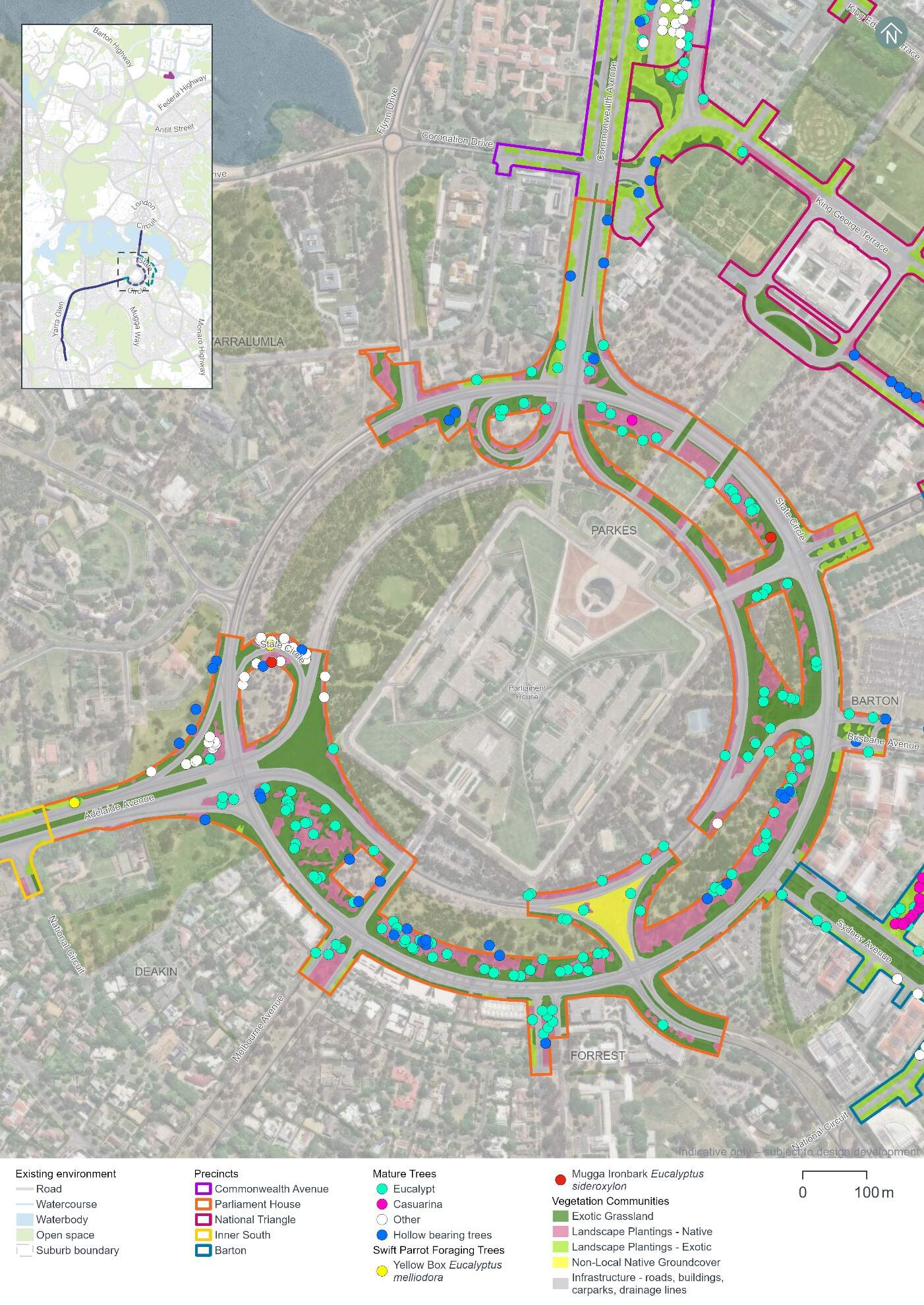
Hollow-bearing trees and mature trees
A total of 38 hollow-bearing trees and 184 mature trees have been recorded in the Parliament House precinct. These trees provide suitable breeding and/or foraging habitat for woodland birds including those identified as having a moderate or high likelihood of occurrence.
The majority of the recorded hollow-bearing trees are species that are endemic to the ACT. A list of hollow-bearing and mature tree species across the Project area is provided in Section 11.2.1 of Chapter 11 (Project-wide issues). Table 13-32 summarises the number of hollow-bearing and mature trees within the Parliament House precinct and is shown on Figure 13-10.
Field work carried out between 2022 and 2024 have identified evidence of some of the hollows being actively used with birds (including Gang-gang Cockatoos) entering and leaving the hollows and displaying breeding behaviours (i.e. chewing around the hollow entrance).
| Precinct | Number of hollow-bearing trees | Hollows1 | Number of mature trees | ||||
|---|---|---|---|---|---|---|---|
|
Extra-small |
Small |
Medium |
Large |
Extra-Large (>30 cm) |
|||
|
Parliament House |
38 |
1 |
28 |
25 |
8 |
3 |
184 |
Notes:
- Some hollow-bearing trees have been recorded as containing more than one hollow.
Threatened fauna habitat assessment
The Golden Sun Moth (Synemon plana) is listed as vulnerable under both the Environment Protection and Biodiversity Conservation Act 1999 (Cth) (EPBC Act) and the Nature Conservation Act 2014 (ACT) (NC Act). A total area of 5.13 ha of potential Golden Sun Moth habitat has been recorded within the Parliament House precinct. This habitat has been identified as low-density (2.35 ha) and high-density (2.78 ha) Chilean needlegrass habitat (refer to Figure 13-11).
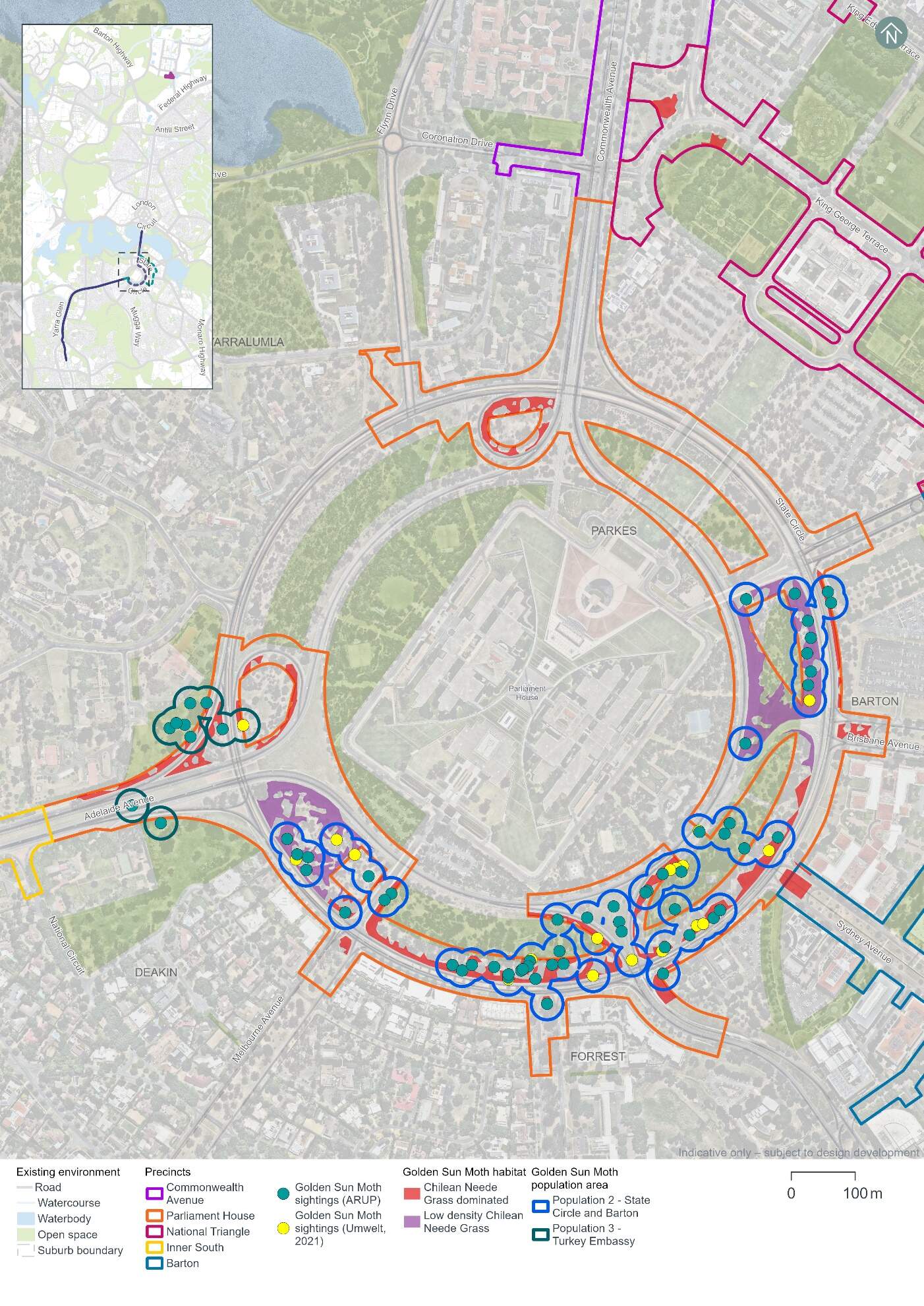
Two Golden Sun Moth populations have been identified in the Parliament House precinct, through previous biodiversity assessments reviewed for this Environmental Impact Statement (EIS) (ARUP, 2021). The locations of the populations are shown on Figure 13-11 and include:
- Population 2 - around State Circle and Barton (Parliament House and Inner South precincts)
- Population 3 - along the western side of State Circle near the Embassy of Türkiye.
Other Golden Sun Moth individuals, populations and habitat across the Project area are identified in Section 11.2 in Chapter 11 (Project-wide issues).
Other potential threatened fauna habitat identified within the Parliament House precinct includes:
- Gang-gang Cockatoo (Callocephalon fimbriatum) (listed as endangered under both the EPBC Act and the NC Act) - the Parliament House precinct supports 8.17 ha of foraging habitat and 23 breeding trees for the species (refer to Figure 13-12)
- Superb Parrot (Polytelis swainsonii) (listed as vulnerable under both the EPBC Act and the NC Act) - the Parliament House precinct supports 8.17 ha of foraging habitat for this species (refer to Figure 13-12)
- Swift Parrot (Lathamus discolor) (listed as critically endangered under both the EPBC Act and the NC Act) - the Parliament House precinct supports two mature Mugga ironbark trees and two mature yellow box trees which comprise foraging habitat, critical for the survival of the species (refer to Figure 13-12)
- Diamond Firetail (Stagonopleura guttata) (listed as vulnerable under both the EPBC Act and the NC Act.) - 8.17 ha of the Landscape Planting - Native community has been identified within the Parliament House precinct and may provide suitable habitat for the Diamond Firetail (refer to Figure 13-12).
No habitat was identified in the Parliament House precinct for the Perunga Grasshopper (Perunga ochracea), Canberra Raspy Cricket (Cooraboorama canberrae), Key's Matchstick Grasshopper (Keyacris scurra), or Striped Legless Lizard (Delma impar).
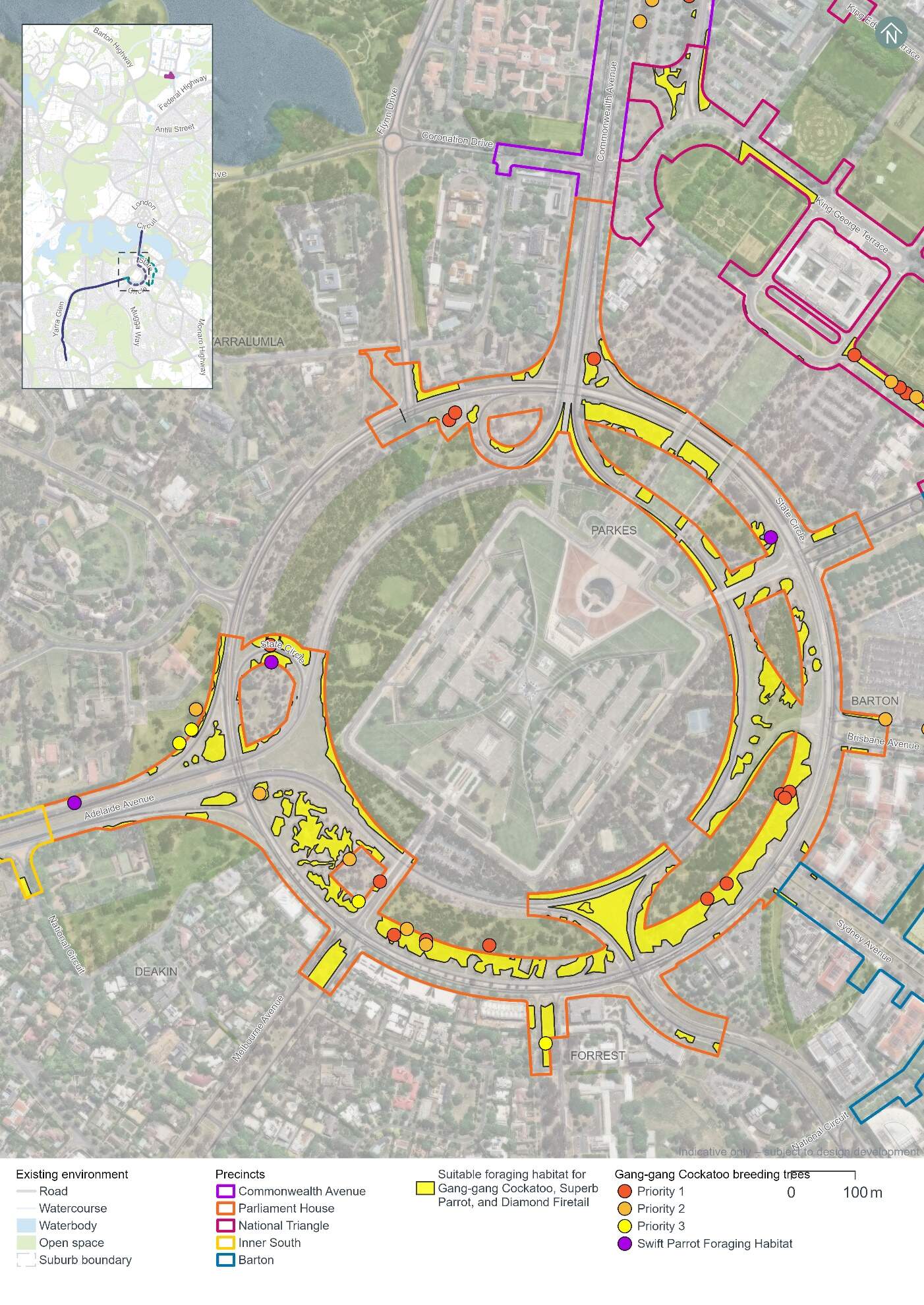
Threated flora and pest plants
No threatened or rare flora species have been recorded in the Parliament House precinct. Impacts to threatened or rare flora species are therefore not anticipated.
Three pest plant species declared under the Pest Plants and Animals Act 2005 (PP&A Act) have been recorded in the Parliament House precinct:
- Chilean needlegrass (Nassella neesiana) - a Weed of National Significance
- African lovegrass (Eragrostis curvula)
- St John's wort (Hypericum perforatum).
13.4.2 Potential impacts - construction
The following section summarises the potential impacts of the Project on biodiversity as a result of construction in the Parliament House precinct.
Vegetation assessment
The Project design has been developed with the aim of avoiding direct and indirect impacts to MNES and other biodiversity values in the landscape. Through this process, a clearance footprint has been defined, as shown on Figure 13-13. Vegetation clearing would not be permitted outside this clearance footprint.
Native and non-native vegetation within the clearance footprint is comprised of four communities as summarised in Table 13-33. Only 2.46 hectares of this vegetation is characterised as native, and all of it is landscape planting rather than remnant native vegetation.
| Vegetation community | Area (ha) |
|---|---|
|
Non-local native ground cover |
0.08 |
|
Landscape plantings - Native |
2.46 |
|
Landscape plantings - Exotic |
0.31 |
|
Exotic grassland |
4.23 |
|
Total vegetation |
7.08 |
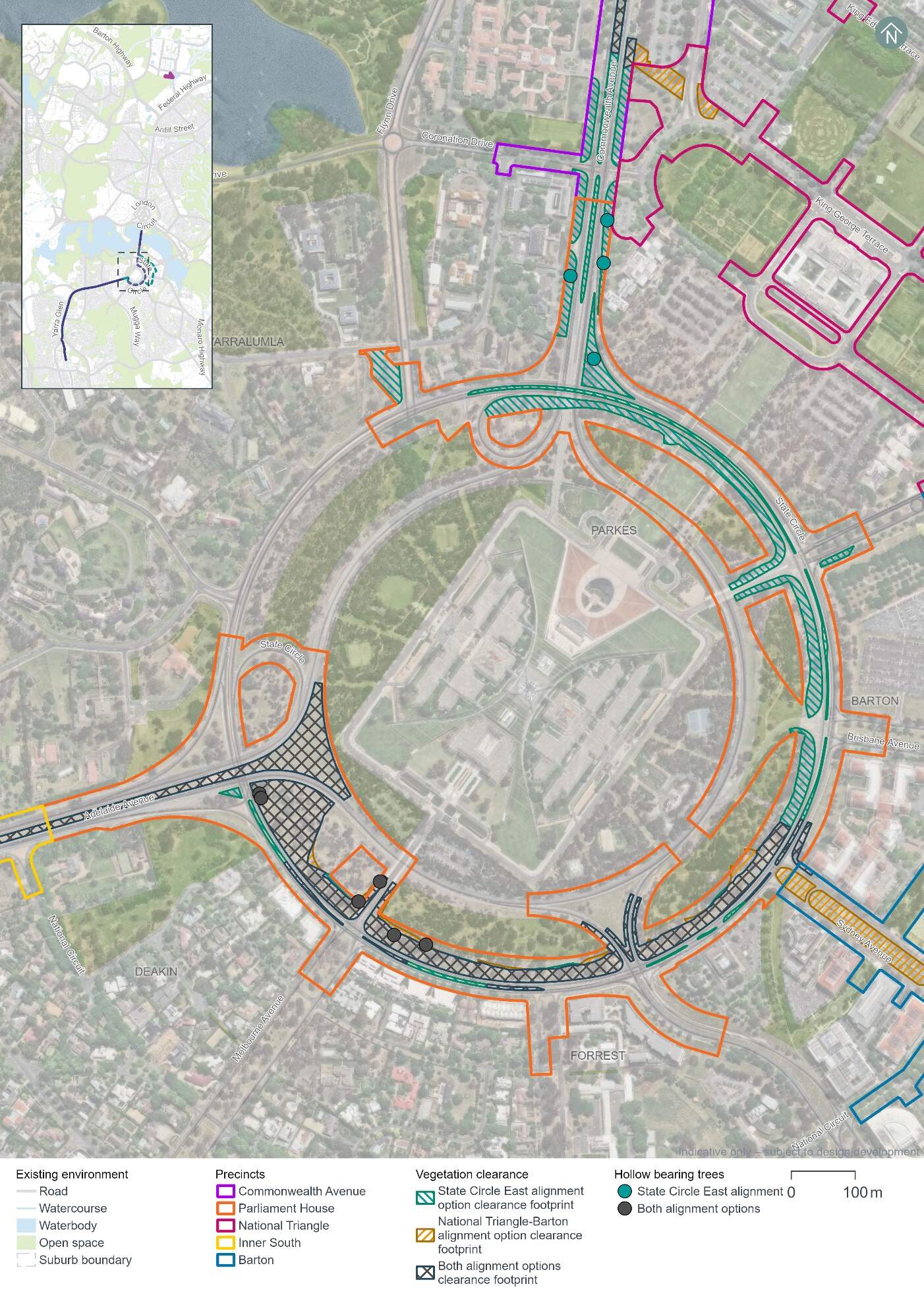
A total of 10 hollow-bearing trees and 60 mature native trees have been recorded in the Parliament House precinct. These trees provide suitable breeding and/or foraging habitat for woodland birds including those identified as having a moderate or high likelihood of occurrence. Table 13-34 summarises the number of hollow-bearing and mature native trees within the Parliament House precinct and is shown on Figure 13-13.
| Precinct | Number of hollow-bearing trees | Hollows1 | Number of mature native trees | ||||
|---|---|---|---|---|---|---|---|
|
Extra-small |
Small |
Medium |
Large |
Extra-Large (>30 cm) |
|||
|
Parliament House |
10 |
0 |
14 |
6 |
4 |
0 |
60 |
Notes:
- Some hollow-bearing trees have been recorded as containing more than one hollow.
Threatened fauna
Potential impacts on threatened fauna within the clearance footprint in the Parliament House precinct would include impacts on the following through habitat removal:
- Golden Sun Moth - 2.47 ha of habitat, including habitat associated with Golden Sun Moth populations 2 and 3
- Gang-gang Cockatoo - 2.46 ha of foraging habitat and six or four breeding trees for the State Circle East and National Triangle-Barton alignment options respectively, which when taken in total with all clearing required for the Project, has the potential to interfere with the recovery of the species
- Superb Parrot - 2.46 ha of foraging habitat for Superb Parrot, which when taken in total with all clearing required for the Project, has the potential to interfere with the recovery of the species
- Swift Parrot - supports one mature Mugga ironbark tree which provides foraging habitat, critical for the survival of the species
- Diamond Firetail - 2.46 ha of the Landscape Planting - Native community which may provide suitable habitat for the species.
Potential impacts on threatened fauna habitat across the clearance footprint is discussed further in Section 11.2.2 of Chapter 11 (Project-wide issues).
No habitat has been identified in the Parliament House precinct clearance footprint for the Perunga Grasshopper, Canberra Raspy Cricket, Key's Matchstick Grasshopper, or Striped Legless Lizard.
Indirect impacts
Native vegetation and habitat adjacent to the clearance footprint, and species using air space above the clearance footprint may be indirectly impacted by the construction works if appropriate management and mitigation measures are not implemented. Management and mitigation measures for biodiversity are discussed further in Chapter 21 (Environmental management and mitigation measures). Potential indirect impacts of construction activities may include:
- Spread of invasive species in the clearance footprint from equipment and machinery
- Noise and vibration impacts on fauna within the vicinity of construction works
- Erosion, sedimentation, and dust impacts on biodiversity values during ground disturbing works
- Waste impacts associated with the storage of fuels and disposal of waste from new equipment and the removal of existing infrastructure
- Increased light pollution on sensitive habitats and species from increased light spill and lighting intensity during construction works
- Fauna strike by construction vehicles within and adjacent to existing roadways.
Further detail on these indirect impacts for construction activities is discussed in Chapter 11 (Project-wide issues).
13.4.3 Potential impacts - operation
Native vegetation and habitat adjacent to the clearance footprint, and species using air space above the Project have the potential to experience indirect impacts from the operation of the Project, for example:
- Noise and vibration impacts within the vicinity of the alignment, from light rail operations
- Increased light pollution on sensitive habitats and species, for example due to lighting around light rail stops
- The addition of light rail vehicles within an existing transport corridor increasing the risk of fauna strike.
There would be no over-head wiring installed in this precinct as part of the Project and therefore there would be no risk of fauna strike with over-head wires. Further detail on these indirect impacts for operational activities is discussed in Chapter 11 (Project-wide issues).
13.4.4 Management and mitigation measures
The Project has sought to avoid and minimise impacts to MNES and other biodiversity values in the landscape, through the development of a clearance footprint within the Project area (refer to Figure 13-13).
Environmental management for this Project is detailed in Part C (Environmental management and conclusion). This includes construction and operational management and mitigation measures (where relevant) in Chapter 21 (Environmental management and mitigation measures) that are applicable to the Project as a whole.
No precinct-specific measures have been identified for biodiversity impacts in the Parliament House precinct.
13.5 Historic heritage
This section provides an assessment of the potential historic heritage impacts associated with the construction and operation of the Project within the Parliament House precinct. Further detail on the heritage impact assessment is provided in Technical Report 3 - Heritage. The methodology applied for this assessment is summarised in Chapter 10 (Assessment methodologies) and discussed in detail in Section 2 of Technical Report 3 - Heritage.
Historic cultural landscapes, natural heritage, and heritage views and vistas have been assessed on a Project-wide basis as such features span across multiple precincts (refer to Section 11.3 of Chapter 11 (Project-wide issues)).
13.5.1 Existing environment
This section provides an overview of the existing historic heritage features within the Parliament House precinct. It also considers the condition, integrity, and sensitivity to change of historic heritage features within the precinct.
Heritage character
The heritage character of the Parliament House precinct is defined by the prominence of Parliament House and Capital Hill, its immediate setting, and its connection to the Parliamentary Zone, National Triangle, and Central National Area.
The precinct symbolises Australia's democracy, with different design styles used to illustrate the progress of place-making in the national capital. Within the landscape, Capital Hill is a terminating feature of the National Triangle. It shows how important national design fits into the Australian landscape by aligning with the Land Axis. This adds grandeur to the view of Parliament House and completes the city's layout as planned in the Griffin Plan for Canberra. The way each of the radiating avenues (Commonwealth, Kings, Brisbane, Sydney, Canberra, Hobart, Melbourne, Adelaide, and Perth) terminate at State Circle emphasises the status of Parliament House.
State Circle marks a difference in character between Parliament House and Capital Hill, and the inner south suburbs. Parliament House is embedded in a planted, naturalistic Australian setting which reflects Canberra's character as the Bush Capital.
The historic heritage assessment identified 12 heritage places (eight listed and four unlisted) within and surrounding the Parliament House precinct, as noted below in Table 13-35 and shown on Figure 13-14.
| Heritage places | Description |
|---|---|
|
Commonwealth Heritage List |
|
|
Parliament House Vista |
The Parliament House Vista along the Land Axis is the most iconic of the intentional vistas created in the Griffin Plan. The open sweeping vista along the Land Axis is experienced in two directions and creates a dramatic view terminating in Capital Hill at one end and Mount Ainslie at the other. The Aboriginal Tent Embassy is included in the Commonwealth Heritage List citation for the Parliament House Vista and is generally understood to be of high cultural significance to both the Aboriginal community and the wider population. Given this vista spans across multiple precincts it is assessed in Section 11.3 of Chapter 11 (Project-wide issues) and is not considered further in this precinct assessment. |
|
State Circle Cutting (refer to Figure 13-15) |
State Circle Cutting has high natural heritage value as it shows sandstone rafts, ripple marks, and a pallid zone assisting in the interpretation of the ancient geological landscape of the Canberra region. However, it has been considerably reduced in scale by the previous excavation of the cutting and is also threatened by vibration damage due to traffic. |
|
West Block and the Dugout (refer to Figure 13-16) |
West Block and the Dugout is on the east side of Commonwealth Avenue and is significant as one of the earliest government buildings in Canberra and is an integral component of the National Triangle landscape. It demonstrates architecture suited to sit within a designed landscape of related buildings and spaces. |
|
Commencement Column Monument |
The Commencement Column is Canberra's foundation monument for the official announcement of Canberra as Australia's new national capital, at a formal ceremony held on Capital Hill in 1913. |
|
York Park North Tree Plantation (refer to Figure 13-17) |
York Park Tree Plantation is located adjacent to the intersection of Kings Avenue and State Circle. There are many trees of the same species (English Oak) in a grid spacing arrangement. The plantation is historically significant for its association with the celebration of the opening of Old Parliament House and the inaugural planting by His Royal Highness the Duke of York in 1927. |
|
The Surveyors Hut |
The Surveyors Hut is a remnant of the original surveyor's camp at Capital Hill in 1909. It is significant as one of the earliest existing Commonwealth buildings, predating the design competition for Australia's new national capital and its eventual construction. |
|
ACT Heritage Register |
|
|
The Presbyterian Church of St Andrew (refer to Figure 13-18) |
The Presbyterian Church of St Andrew is located on State Circle between Sydney Avenue and Canberra Avenue and is significant as an early church built in an inter-war gothic style. The church and its surroundings of mature plantings strengthen its historical value. |
|
Unlisted significant heritage places |
|
|
Parliament House and surrounds (refer to Figure 13-19) |
Parliament House is culturally significant as a creative and technical achievement in the way the architecture integrates with the landscape to symbolise the area as the centre of Canberra, and the focal point of the Parliamentary Triangle, expressing the Griffin Plan's concept for a capital that symbolises democracy. Given this heritage place spans multiple precincts, it is assessed in Section 11.3 of Chapter 11 (Project-wide issues) and is not considered further in this precinct assessment. |
|
Roads on national land - Commonwealth Avenue, Kings Avenue, State Circle, and Capital Circle |
Commonwealth and Kings Avenues are two of the three original major avenues for Canberra, and together with Constitution Avenue they form the Parliamentary Triangle. Their symmetry, tree-lined avenues, plantings, landscape setting, and geometry contribute to an understanding of the Griffin Plan. They are significant as individual places and as part of the broader historical urban designed landscape of Canberra. State Circle and Capital Circle encircle Parliament House, framing Capital Hill. The smoothed contours, grassed verge edges, and massed native plantings between State and Capital Circles are significant by creating a 'natural Australian' aesthetic as the appropriate setting for the nation's parliament and reflect the principles of Canberra as a designed city in the landscape. Given this heritage place spans multiple precincts, it is assessed in Section 11.3 of Chapter 11 (Project-wide issues) and is not considered further in this precinct assessment. |
|
Canberra: the Planned National Capital |
Canberra's planned national landscape is a significant expression of the Griffin Plan that is highly valued by the Canberra and Australian communities. It is formed of public parklands, significant views along axes and across the Central National Area, tree-lined boulevards, a geometric layout, and Lake Burley Griffin. The landscape is nationally significant due to its:
Given this heritage place spans multiple precincts, it is assessed in Section 11.3 of Chapter 11 (Project-wide issues) and is not considered further in this precinct assessment. |
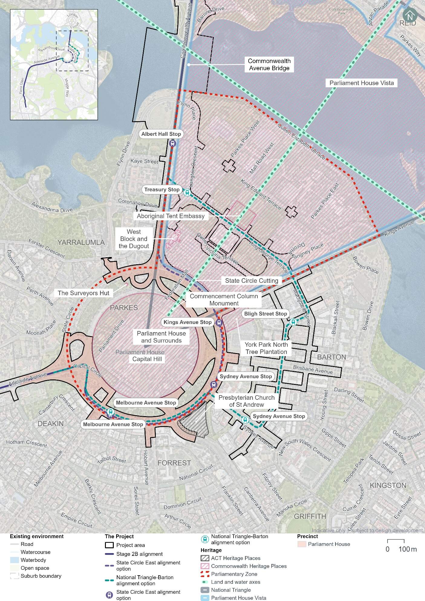
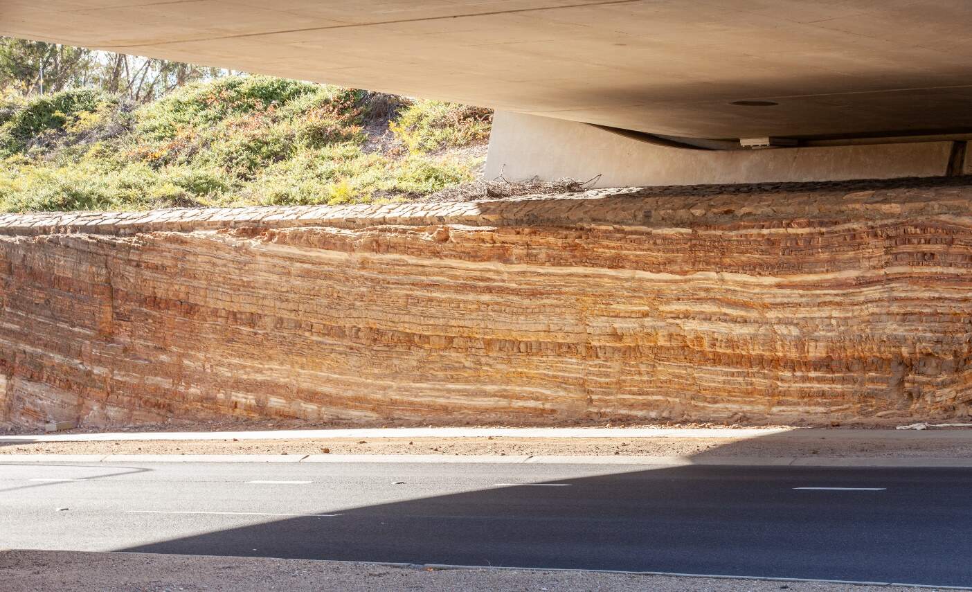
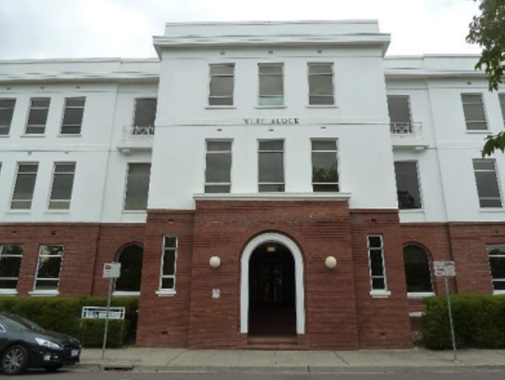

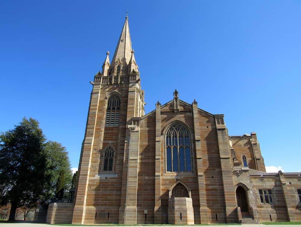
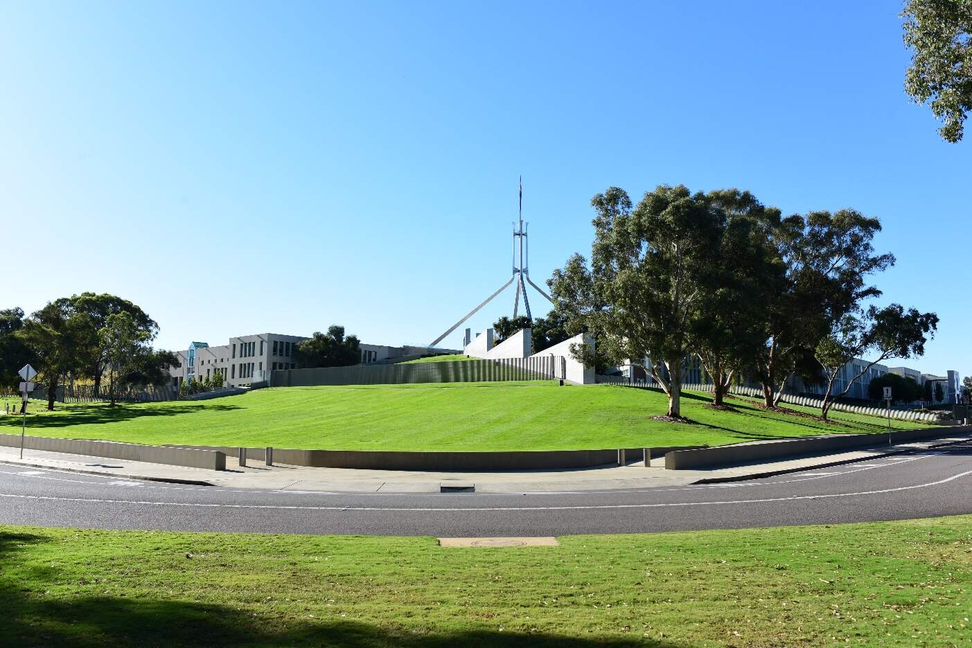
Condition, integrity, and sensitivity to change
The existing heritage within the Parliament House precinct is generally in good condition. The landscape and structures are well maintained.
The integrity of the heritage values is good. The heritage features of the precinct are effective in expressing its character as part of the broader designed landscape of Canberra's Central National Area. Some changes over time, particularly the removal of original Weston-planted evergreens at the southern end of Commonwealth Avenue, and the excavation of the upper tier of State Circle Cutting, both for the construction of Parliament House, have reduced the ability to interpret its heritage character to some degree.
The precinct has moderate to high sensitivity to change. As a central element of a historic designed landscape of national importance, Capital Hill, Parliament House and its immediate surrounds are sensitive to alterations which could obscure or detract from expression of its symbolic and tangible position in Australian democracy and the Central National Area of Canberra. The reduced integrity of key features such as the State Circle Cutting and trees along Commonwealth Avenue mean these elements are particularly sensitive to future change.
13.5.2 Potential impacts - construction
Table 13-36 summarises the potential construction impacts of the Project on heritage places in the Parliament House precinct for both alignment options. Where an alignment option would not involve light rail construction in the vicinity of a heritage place (based on the proposed location of light rail trackform and stops), no impact has been identified in Table 13-36.
| Heritage place | Construction impact State Circle East alignment option | Construction impact National Triangle-Barton alignment option |
|---|---|---|
|
Commonwealth Heritage List |
||
|
State Circle Cutting |
Nil
|
No impacts |
|
West Block and the Dugout |
Moderate
|
No impacts |
|
Commencement Column Monument |
Nil
|
No impacts |
|
York Park North Tree Plantation |
Nil
|
No impacts |
|
The Surveyors Hut |
Nil
|
No impacts |
|
ACT Heritage Register |
||
|
The Presbyterian Church of St Andrew |
Nil
|
|
Construction impacts on Parliament House Vista, Parliament House and surrounds, Roads on national land - Commonwealth Avenue, Kings Avenue, State Circle, and Capital Circle, and Canberra: the Planned National Capital have been assessed in Section 11.3 of Chapter 11 (Project-wide issues).
13.5.3 Potential impacts - operation
Table 13-37 summarises the potential operation impacts of the Project on heritage places in the Parliament House precinct for both alignment options. Where an alignment option would not involve light rail operation in the vicinity of a heritage place (based on the proposed location of light rail trackform and stops), no impact has been identified in Table 13-37.
| Heritage place | Operation impacts State Circle East alignment option | Operation impacts National Triangle-Barton alignment option |
|---|---|---|
|
Commonwealth Heritage List |
||
|
State Circle Cutting |
Nil
|
No impacts |
|
West Block and the Dugout |
Nil
|
No impacts |
|
Commencement Column Monument |
Nil
|
No impacts |
|
York Park North Tree Plantation |
Nil
|
No impacts |
|
The Surveyors Hut |
Nil
|
No impacts |
|
ACT Heritage Register |
||
|
The Presbyterian Church of St Andrew |
Nil
|
|
Operation impacts on Parliament House Vista, Parliament House and surrounds, Roads on national land - Commonwealth Avenue, Kings Avenue, State Circle, and Capital Circle, and Canberra: the Planned National Capital have been assessed in Section 11.3 of Chapter 11 (Project-wide issues).
13.5.4 Precinct specific management and mitigation measures
Environmental management for this Project is detailed in Chapter 21 (Environmental management and mitigation measures). This includes construction and operational mitigation measures to manage historic heritage impacts, that are applicable to the Project as a whole.
No further precinct-specific measures have been identified for historic heritage impacts at the Parliament House precinct.
13.6 Landscape character and visual amenity
This section provides an assessment of the potential landscape character and visual amenity impacts associated with the construction and operation of the Project within the Parliament House precinct. Further detail on the landscape character and visual amenity assessment is provided in Technical Report 10 - Landscape character and visual amenity. The methodology applied for the assessment is summarised in Chapter 10 (Assessment methodologies) and Section 2 of Technical Report 10 - Landscape character and visual amenity.
The landscape character assessment describes the physical, cultural, and heritage attributes of the landscape, planning designations, and desired character within each of the precincts. The assessment of visual impact has considered the impact of change on the views available to people and their visual amenity.
For the purposes of this assessment, the precinct boundaries have been expanded beyond the Project area, as shown on Figure 13-20.
13.6.1 Existing environment
The Parliament House precinct is located south of Coronation Drive and circles the eastern edge of Capital Hill along State Circle, connecting to Adelaide Avenue. It surrounds the Australian Parliament House, sitting at the top of Capital Hill and overlooking Canberra. State Circle marks the base of Capital Hill, with its southern part lying in the valley between Capital Hill and Red Hill.
State Circle was established as part of the Griffin Plan (NCA, 2007), and forms the geometry of the National Triangle and Capital Hill. This area prioritises traffic over pedestrian access. It continues the character of Commonwealth Avenue, transitioning to a curving road surrounded by woodland on the inner edge of Capital Hill. The precinct is characterised by native woodland on the inner side of State Circle and exotic, deciduous street trees on the outer side.
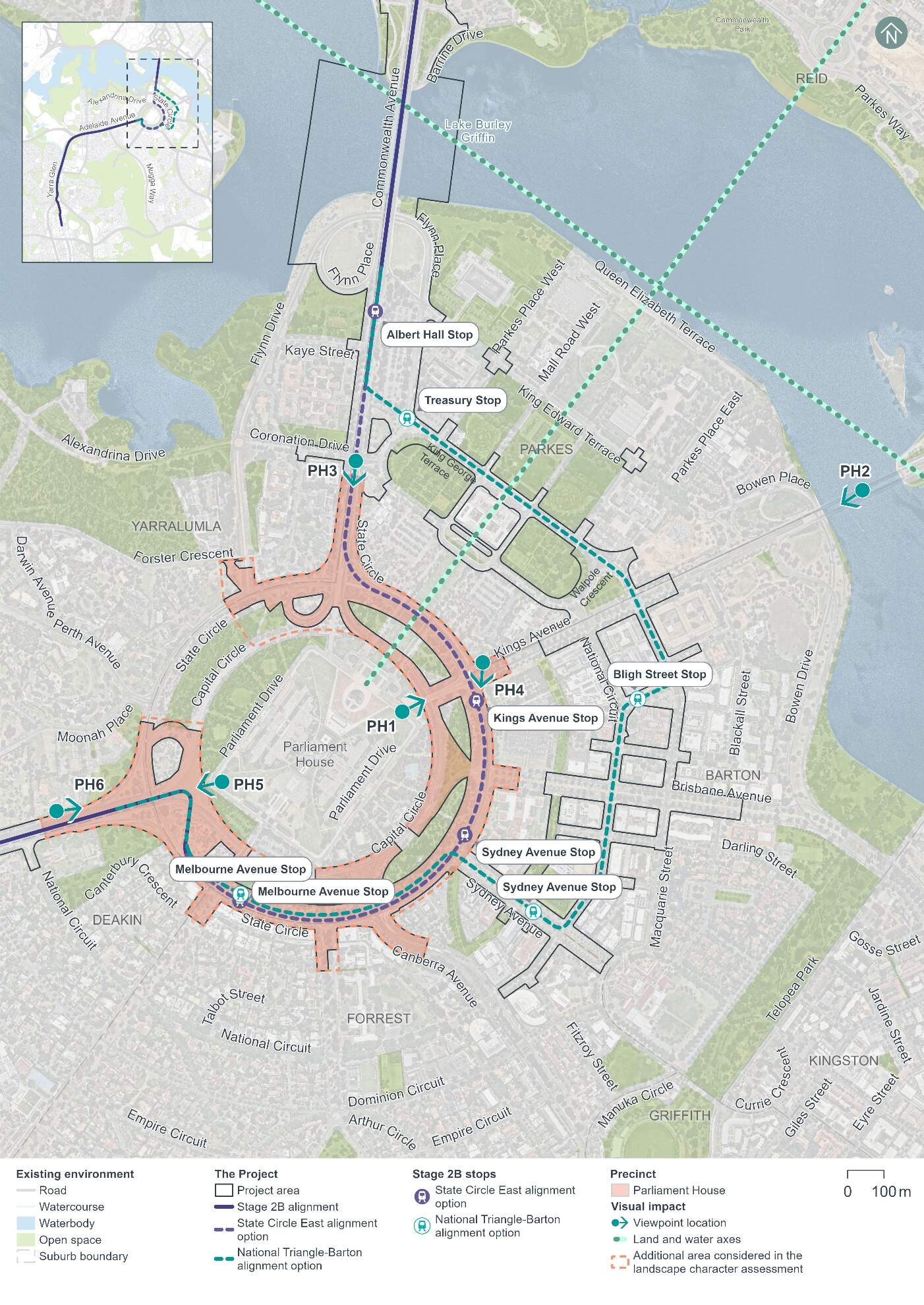
Landscape character
The key aspects of landscape character in the Parliament House precinct can be seen on Figure 13-21 and Figure 13-22. Running adjacent to Parliament House, this precinct surrounds the building comprising the peak of Capital Hill and overlooking Canberra. State Circle presents the base of Capital Hill with the southern portion of the road sitting within the valley between the Capital Hill and the ridgeline of Red Hill.
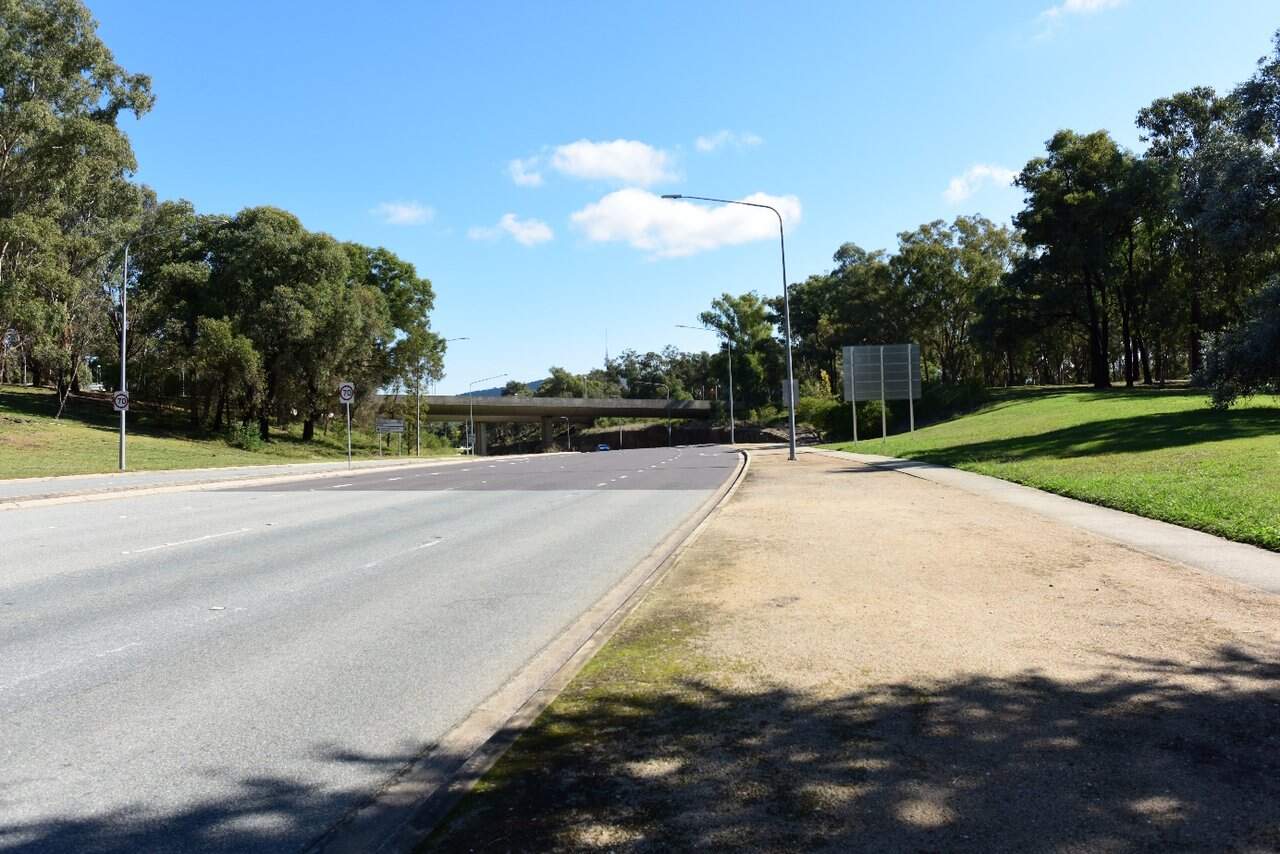
Capital Hill and Parliament House form the tip of the National Triangle. Canberra has been developed with Capital Hill forming a notable topographical element, with views along the avenues which radiate out from this landmark. The fall across the precinct from the inner edge of Capital Hill to the surrounding avenues is a characteristic element.
This precinct is dominated by the wide corridor of State Circle, Capital Hill and the radiating avenues (Commonwealth Avenue and Kings Avenue) which form part of the National Triangle. The southern portion of Commonwealth Avenue aligns with the Commonwealth Avenue precinct before it transitions to the curving road of State Circle, bordered by a woodland buffer on the inner edge of Capital Hill (refer to Figure 13-22).
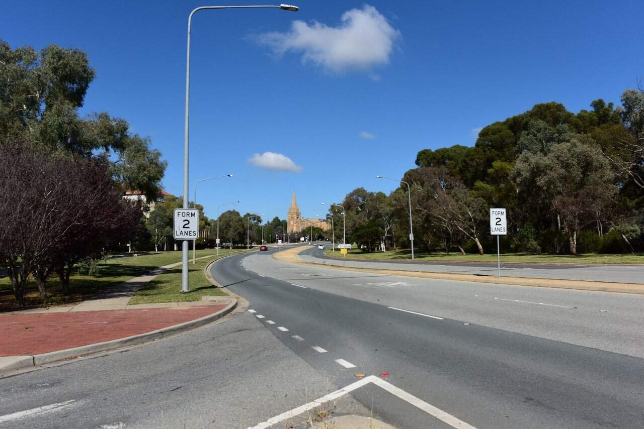
Vegetation within the precinct comprises the native woodland on the inner edge of State Circle and predominantly exotic, deciduous street trees on the outer edge of the road. The wide, green verges reflect the Griffin Plan, which responds to the topography of the landscape. The woodland buffer on Capital Hill contributes to the Bush Capital character highlighting the intrinsic value of the location and setting of Parliament House.
The precinct is near several listed heritage items contributing to its heritage values including the State Circle Cutting, York Park North Tree Plantation (refer to Figure 13-23), Parliament House Vista, The Lodge, and the Presbyterian Church of St Andrew.
Further information on the heritage items listed above can be found in Section 13.5.
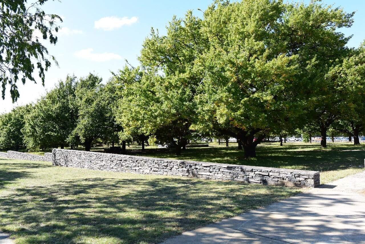
Viewpoints
Representative viewpoints that have been identified to assess visual impacts within the Parliament House precinct are shown on Figure 13-20 and described in Table 13-38. Images of all viewpoints can be found in Technical Report 10 - Landscape character and visual amenity.
| Viewpoint | Description | Sensitivity rating |
|---|---|---|
|
Viewpoint PH1: Parliament House North-east |
This viewpoint is located on the lawn at the northern corner of Parliament House looking north-east along Kings Avenue towards the Australian-American Memorial. The foreground of the view is dominated by the green lawn of Parliament House, sloping down to Parliament Drive and Kings Avenue. This viewpoint would be a popular tourist destination, where receptors' attention would be focussed on the surrounding landscape. The quality of the view is paramount to the visitor experience. Most visitors are likely to pause to appreciate the view before moving on. The view sensitivity is high due to its position within an important area from a heritage and planning perspective. This viewpoint would be a popular tourist spot and forms part of the National Triangle. |
High |
|
Viewpoint PH2: Kings Avenue Bridge |
This viewpoint is located centrally on the Kings Avenue Bridge looking south-west towards Parliament House. The view comprises separated east and westbound carriageways and northern footpath of Kings Avenue, extending west. The Kings Avenue road corridor and steel barricading dominates the foreground of the view, with the two-lane carriageways, and the shared path. Receptors seeing this view would include pedestrians, cyclists, and motorists travelling across Kings Avenue bridge. The view sensitivity is negligible as there would be no view to the Project from this viewpoint. As a result of this rating, Viewpoint PH2 has not been assessed further in the visual impact assessment. |
Negligible - not assessed further |
|
Viewpoint PH3: Commonwealth Avenue at Coronation Drive |
This viewpoint is located within the median of Commonwealth Avenue at the intersection with Coronation Drive, looking south towards Parliament House (refer to Figure 13-24). The view comprises the separated south and northbound carriageways of Commonwealth Avenue extending south towards Parliament House, elevated on Capital Hill in the background. While most of the visual receptors who would see this view would be passers-by, a proportion of these would be visitors who would be travelling along Commonwealth Avenue between landmarks. These receptors would be more focussed on the view, particularly as the view culminates in Parliament House to the south and City Hill to the north. The view sensitivity is high due to the importance of views along main avenues as part of the National Triangle and surrounding landmarks. |
High |
|
Viewpoint PH4: State Circle at Kings Avenue |
This viewpoint is located on the pedestrian path of State Circle at the intersection with Kings Avenue, looking south along State Circle with Parliament House to the right of the viewpoint (refer to Figure 13-26). The central view comprises the road corridor of State Circle. The middle and background of the view features tree plantings either side of State Circle, with native woodland on the inner verge and a mix of native and deciduous trees on the outer verge. Receptors largely include pedestrians, cyclists, and motorists travelling along State Circle; however, a proportion of these would be visitors who would be travelling along State Circle to access Parliament House. These receptors would be more focussed on the view. The view sensitivity is high due to its location within an important view corridor and the visibility of important heritage elements. |
High |
|
Viewpoint PH5: Parliament House South-west |
This viewpoint is located at a lookout point at the south-west corner of the Parliament House grounds, looking south-west along Adelaide Avenue. The foreground of the view comprises a collection of native tree canopies and shrubs planted in the embankment below Parliament Drive. Beyond the vegetation, a large area of lawn extends to between the carriageways of Adelaide Avenue. Visual receptors at this viewpoint would mostly be pedestrians, including visitors and staff of Parliament House. However, it is unlikely that these groups would observe the view unless particularly seeking it out. The view sensitivity is moderate. Despite its location within an important heritage item along a main avenue, the view south-west is mostly screened by native vegetation. |
Moderate |
|
Viewpoint PH6: Adelaide Avenue East. |
This viewpoint is located on the northern verge of Adelaide Avenue near the connection to State Circle and The Lodge, looking north-east towards Parliament House (refer to Figure 13-28). The view comprises the turf verge, eastbound carriageway, and wide turf median of Adelaide Avenue extending east towards Parliament House. While most visual receptors would be motorists, a proportion of these would be visitors who would be travelling along Adelaide Avenue towards central Canberra due to its value as a destination. These receptors would be more focussed on the view, particularly as the view culminates in Parliament House. The view sensitivity is moderate. Despite its location near two important heritage items (Parliament House and The Lodge) along a main avenue, it is anticipated that most receptors would be local motorists rather than visitors with less overall focus on the landscape as they pass. Additionally, The Lodge is not visible in this view due to vegetation screening both on Capital Hill and at The Lodge. |
Moderate |
Night-time lighting
Both alignment options sit within the setting of the base of Capital Hill, within an area of A3: Medium district brightness based on Australian Standard 4282:2023 (Standards Australia, 2023). The lighting along these corridors would be cut-off street and pedestrian lighting to contribute to the high quality landscape boulevards and not distract from the feature lighting of Parliament House and other nationally significant buildings or interrupt views to these elements.
Relevant design requirements of strategy 1a of the National Capital Authority's (NCA's) Outdoor Lighting Policy for the Parliament House precinct include:
- Create a unique identity for the roads that form the Griffins' National Triangle, being Commonwealth, Kings and Constitution Avenues, through careful selection and installation of an integrated suite of street furniture and lighting. Achieve a high degree of uniformity in lighting performance on these three main avenues
- Illuminate the Griffins' Land Axis by retaining the existing Anzac Parade street lighting and illumination of Federation Mall
- Use full cut-off light fittings in all landscape areas, roads, paths, and car parks within the Central National Area
- Use full cut-off street and pedestrian lighting on all main avenues that contributes to their development as high quality landscape boulevards
- Align lighting hardware to strengthen the framing of the National Triangle, main avenues, and formally landscaped open spaces.
13.6.2 Potential impacts - construction
Landscape character impact assessment
The construction of the Project would result in both the addition of construction activity, equipment, and construction compounds and loss of elements (most notably trees) within the Parliament House precinct, including:
- The addition of temporary fencing, hoarding, signage, and traffic safety equipment
- Removal of existing vegetation (most notably trees), furniture, and signage, as needed
- Activities including earthworks, track construction, drainage adjustments, and road improvements
- Construction of structures, including light rail stops, retaining walls, bridges, and covered sections
- Installation of lighting, signage, and landscaping
- Temporary traffic changes
- Establishment of construction compounds.
These changes would alter many aesthetic aspects and key characteristics within the precinct.
Construction activities in any one location would be temporary may experienced over the short term as construction activities progress along the alignment.
As such, the magnitude of change during construction is considered to be high within the Parliament House precinct due to the visual clutter of construction and the removal of trees. This would result in a high adverse impact on landscape character during construction.
Visual impact assessment
The visual impact assessment considered the sensitivity of existing viewpoints to change and the magnitude (scale, character, and distance) of the change of view. During the construction phase within the Parliament House precinct, in most cases the overall impact at each viewpoint has been assessed as being high to moderate due to:
- High to moderate sensitivity of most viewpoints to change
- High heritage values of views across this precinct
- High magnitude of works anticipated throughout construction that would be visible in the fore, middle, and background of most viewpoints.
A description of the anticipated change in view and associated potential impacts on the Project during construction is provided in Table 13-39. Potential impacts would differ between the State Circle East and National Triangle-Barton alignment options for some of these viewpoints, or impacts would only be seen with one alignment option. These differences have been specified as appropriate in the table below.
| Viewpoint | Anticipated change in view | Impact summary |
|---|---|---|
|
Viewpoint PH1: Parliament House North-east |
State Circle East alignment option only: The view to the construction activity would be framed by the mature avenue tree planting that focuses the view from this location along Kings Avenue to the American-Australian Memorial. Construction activities would be screened by the dense vegetation along State Circle. Construction would also partially obstruct the distant view down Kings Avenue towards the Australian-American Memorial. |
Sensitivity: High |
|
Magnitude: Moderate |
||
|
Overall impact: High to moderate |
||
|
Qualitative rating: Adverse |
||
|
Viewpoint PH2: Kings Avenue Bridge |
State Circle East alignment option only: The sensitivity of this view to construction of the Project is negligible as State Circle is not visible from the viewpoint due to screening and distance. Therefore, potential impacts at this viewpoint have not been assessed further and are assumed to be negligible. |
Sensitivity: Negligible |
|
Magnitude: Negligible |
||
|
Overall impact: Negligible |
||
|
Qualitative rating: Neutral |
||
|
Viewpoint PH3: Commonwealth Avenue at Coronation Drive |
State Circle East alignment option only: Changes during construction would be seen across the fore, middle, and background of this viewpoint and would comprise additional transport infrastructure within the view. The construction activity, while temporary, would be visually prominent, particularly due to the close proximity of the changes to the view and the scale of the construction activities and equipment required. Additionally, the construction of the covered section to State Circle would result in additional infrastructure elements within the view. The visual clutter of construction activity would become the dominant feature within the view, rather than the composition of the extended view along a main avenue towards a landmark feature. |
Sensitivity: High |
|
Magnitude: High |
||
|
Overall impact: High |
||
|
Qualitative rating: Adverse |
||
|
Viewpoint PH4: State Circle at Kings Avenue |
State Circle East alignment option only: Construction activity would be seen along State Circle and a portion of Kings Avenue with the most substantial changes comprising the removal of a small number of mature trees and construction of a light rail stop (Kings Avenue Stop) within a narrow section of the overall road corridor. The change would be in contrast to the existing, established landscape and would be visible in the fore, middle, and background. The visual clutter of construction activity would become the predominant characteristic within the view. |
Sensitivity: High |
|
Magnitude: High |
||
|
Overall impact: High |
||
|
Qualitative rating: Adverse |
||
|
Viewpoint PH5: Parliament House South-west |
Vegetation in the foreground of the view would provide partial screening to the nearby construction compound, which would occupy the large expanse of lawn in the middle ground of the view. Large scale construction activities and equipment would be positioned within the view, especially associated with the bridge construction over State Circle. These construction elements and activities would partially obstruct the distant view of Parliament House along Adelaide Avenue. The low number of receptors likely to experience the view and screening vegetation would reduce the visual impact at this location. |
Sensitivity: Moderate |
|
Magnitude: Moderate |
||
|
Overall impact: Moderate |
||
|
Qualitative rating: Adverse |
||
|
Viewpoint PH6: Adelaide Avenue East |
Construction activities and equipment visible from this viewpoint would be in contrast to the existing, established landscape along a main avenue. The construction activity would be visually prominent within the view, particularly due to the close proximity of the changes and the scale of the equipment. The construction of the bridge across State Circle would require construction elements that may include cranes and other tall equipment. The visual clutter of construction activity would become the dominant feature within the view, rather than the composition of the extended view along a main avenue towards a landmark feature. |
Sensitivity: Moderate |
|
Magnitude: High |
||
|
Overall impact: High to moderate |
||
|
Qualitative rating: Adverse |
Night-time visual impact assessment
Works in the Parliament House precinct may need to be undertaken outside standard construction hours (Monday to Saturday, 7am to 6pm). Night works may also be required with most of the works occurring within and directly adjacent to the existing road corridor.
The construction of the covered section and the light rail bridge on Adelaide Avenue above State Circle would require prominent lighting. These works would be more prominent due to the large equipment required to construct these elements. This would be visible from key locations such as the Acton Peninsula, Black Mountain, Parliament House, and Mount Ainslie. Night works may also include the construction of the covered section within the Commonwealth Avenue and State Circle corridors.
Additional lighting from night works within the precinct would be seen from the adjacent commercial, religious, and residential properties whereby residential properties between Canberra Avenue and Adelaide Avenue along State Circle would be most sensitive to the temporary lighting and vehicle movement.
The Capital Hill West construction compound would be established between Adelaide Avenue and Capital Circle. The construction compound would require temporary lighting to prioritise safety and security of the facility. Lighting associated with night works may also draw attention away from the feature lighting of Parliament House, however mature tree planting would provide some visual buffering in this scenario.
For these reasons, the visual impact during construction at night would be moderate adverse.
13.6.3 Potential impacts - operation
Landscape character impact assessment
The assessment of landscape effects considers how the Project will impact the landscape more broadly. It is based on the landscape's sensitivity to change and the expected scale of change. Table 13-40 summarises the anticipated changes and potential impacts of the Project on landscape character.
| Alignment option | Anticipated change | Impact summary |
|---|---|---|
|
State Circle East alignment option |
The Project would introduce light rail infrastructure along Commonwealth Avenue and State Circle, including three stops at Melbourne Avenue, Sydney Avenue, and Kings Avenue, a covered section that would transition between Commonwealth Avenue and State Circle, and a light rail bridge from State Circle to Adelaide Avenue. These changes would impact the precinct's established landscape character. The addition of embedded and green track, signage, lighting, and adjustments to road configurations would lead to changes within the median, requiring the replacement of mature trees with juvenile species. These changes would introduce new elements in a highly sensitive area with heritage and landscape significance, thus impacting the precinct's traditional planting layout and aesthetic. Although replacement trees would retain some formal planting effects, the density and arrangement would differ. While the Project would thoughtfully integrate with the existing infrastructure and preserve key spatial characteristics, including through the use of wire-free running, it would result in an adverse change in the precinct's character, especially due to the introduction of large elements and tree replacements within this historically and culturally sensitive area. The addition of the covered section and the light rail bridge between State Circle and Adelaide Avenue would constitute some of the largest changes in this precinct. However, these elements would be consistent with the existing character of the precinct, where curving connecting roads between avenues are a common feature, particularly within and around Capital Hill. Other key aesthetic and perceptual elements of the precinct would be retained and protected, including road corridors framed by tree planting as well as strong, linear elements that assist in orientation, highlight landmarks and introduce drama and emphasis to areas and items within the landscape. |
Sensitivity: High |
|
Magnitude: High |
||
|
Overall impact: High |
||
|
Qualitative rating: Adverse |
||
|
National Triangle-Barton alignment option |
The Project would introduce light rail infrastructure along State Circle through to Adelaide Avenue, including one stop near Melbourne Avenue, extending between Barton precinct to the Inner South precinct. Positioned within the inner road verge of State Circle, the light rail would consist of embedded and green track with associated elements such as signage, lighting, and passing LRVs, along with adjustments to median widths, intersections, and road configurations. A light rail bridge from State Circle to Adelaide Avenue would be introduced, alongside tree removal and replacement with juvenile species. The most substantial impact to landscape character would occur where the light rail interfaces with the landscape areas of State Circle's inner verge whereby the topography and vegetation of Capital Hill would be impacted. This would include the removal of mature trees, addition of retaining walls, additional lighting and signage. The removal of existing street trees would create a substantial change to the landscape, with replacement trees retaining the avenue's linear character but differing in species and arrangement. While the Project would thoughtfully integrate with the existing infrastructure and preserve key spatial characteristics, including through the use of wire-free running, it would result in an adverse change in the precinct's character, especially due to the introduction of large elements and tree replacements within this historically and culturally sensitive area. Overall, the Project would result in a high to moderate adverse change to the precinct's character. |
Sensitivity: High |
|
Magnitude: Moderate |
||
|
Overall impact: High to moderate |
||
|
Qualitative rating: Adverse |
Visual impact assessment
The visual impact assessment considered the sensitivity of existing viewpoints to change and the magnitude (scale, character, and distance) of the change of view. During operation within the Parliament House precinct, in most cases the overall impact at each viewpoint has been assessed as being moderate due to:
- High to moderate sensitivity of most viewpoints to change
- Viewpoints ranging from high to moderate to low magnitude of change, the main impact being views of passing LRVs.
Neutral to beneficial changes to visual amenity would also occur at some viewpoints due to the preservation of turf or trees and planting of trees in the median/verges.
A description of the anticipated change in view and associated potential impacts on the Project during operation are discussed in Table 13-41. Potential impacts would differ between the State Circle East and National Triangle-Barton alignment options for some of these viewpoints, or impacts would only be seen with one alignment option. These differences have been specified as appropriate in the table below.
| Viewpoint | Anticipated change in view | Impact rating |
|---|---|---|
|
Viewpoint PH1: Parliament House North-east |
State Circle East alignment option only: Once construction is complete, the most visually prominent change within the view would be periodically passing LRVs. The addition of light rail infrastructure within the median of State Circle may be visible from this viewpoint, however, would be difficult to discern due to the viewing distance and the small portion of the overall view that this change would effect. While the upgrade of the road pavement and footpaths would be a positive outcome, the ground plane would only just be visible from this viewpoint due to the distance and change in levels. Passing LRVs, while a new element within the view, would be similar in character to other larger vehicles passing along State Circle, and would not alter the quality of the view. |
Sensitivity: High |
|
Magnitude: Low |
||
|
Overall impact: Moderate |
||
|
Qualitative rating: Neutral |
||
|
Viewpoint PH2: Kings Avenue Bridge |
State Circle East alignment option only: The sensitivity of this view to operation of the Project is negligible as State Circle is not visible from the viewpoint due to screening and distance. Therefore, potential impacts at this viewpoint have not been assessed further and are assumed to be negligible. |
Sensitivity: Negligible |
|
Magnitude: Negligible |
||
|
Overall impact: Negligible |
||
|
Qualitative rating: Neutral |
||
|
Viewpoint PH3: Commonwealth Avenue at Coronation Drive |
State Circle East alignment option only: The turf ground plane in the central median of Commonwealth Avenue would be preserved at this viewpoint through the use of green track. The open, wide view along the main avenue would also be preserved, including the view to Parliament House and Capital Hill. However, the addition of the covered section, removal of mature trees, planting of juvenile trees in the median, and the introduction of LRVs within the view would increase the scale and activity within the road corridor. An indicative visualisation of the Project, once operational, from Viewpoint PH3 is provided on Figure 13-25. |
Sensitivity: High |
|
Magnitude: High |
||
|
Overall impact: High |
||
|
Qualitative rating: Adverse |
||
|
Viewpoint PH4: State Circle at Kings Avenue |
State Circle East alignment option only: The Project would result in the addition of a light rail stop and associated infrastructure within the road reserve of State Circle, with changes to the traffic conditions across the Kings Avenue intersection. A small number of mature trees on the inner verge of State Circle would be removed, however, a row of trees would be planted within the central median of the light rail and would comprise a new element within the view. These changes would be visually prominent, seen in close proximity of the viewpoint and extending into the background. The most prominent elements would include the addition of tree planting within the median of the road corridor and addition of a light rail stop. The addition of a light rail stop and associated light rail infrastructure within the view would slightly widen the view of the transport corridor and add a built form to the view. Long views along the curving road would be somewhat shortened by the inclusion of the light rail stop. Tree planting within the median may interrupt views to Parliament House from this viewpoint, however, this view is not noted as a key view corridor towards the landmark. An indicative visualisation of the Project, once operational, from Viewpoint PH4 is provided on Figure 13-27. |
Sensitivity: High |
|
Magnitude: High |
||
|
Overall impact: High |
||
|
Qualitative rating: Adverse |
||
|
Viewpoint PH5: Parliament House South-west |
At operation, the trackform would extend along Adelaide Avenue within the centre of the view, crossing a light rail bridge over State Circle, between the carriageways. The light rail would extend into the background centrally along Adelaide Avenue, comprising green track, wire-free running and including a double row of trees on either side of the trackform. The most discernible elements of change within this view would comprise the addition of light rail infrastructure, including a light rail bridge, within the median extending the length of Adelaide Avenue within the view. Planted trees within the central median would also comprise a new element within the view, changing the open composition of the view along the road corridor. The changes would be visually recessive due to the foreground screening and the use of green track. |
Sensitivity: Moderate |
|
Magnitude: Moderate |
||
|
Overall impact: Moderate |
||
|
Qualitative rating: Neutral |
||
|
Viewpoint PH6: Adelaide Avenue East |
At completion, the most visually prominent elements of the Project visible from this viewpoint would include a light rail bridge over State Circle, between the road corridors transitioning from Adelaide Avenue to Capital Circle. The light rail would be positioned within the median, comprising green track and wire-free running. The turf of the central median would be preserved and the addition of the bridge within the view would be viewed as a continuation of the road corridor. The addition of trees and passing LRVs within the median would result in a contrast to the existing condition, however, passing LRVs would be visually similar to passing buses (albeit within the median, where traffic was previously absent) and temporary within the view as they pass. The addition of trees within the median would compress the width of the viewing corridor towards Parliament House, reducing the visual prominence of the road corridor by splitting the carriageways with a vertical element. Although the addition of light rail tracks within the median would be a new element within the view, the use of green track would preserve the visual aesthetic of the turf median. An indicative visualisation of the Project, once operational, from Viewpoint PH6 is provided on Figure 13-29. |
Sensitivity: Moderate |
|
Magnitude: Moderate |
||
|
Overall impact: Moderate |
||
|
Qualitative rating: Neutral |
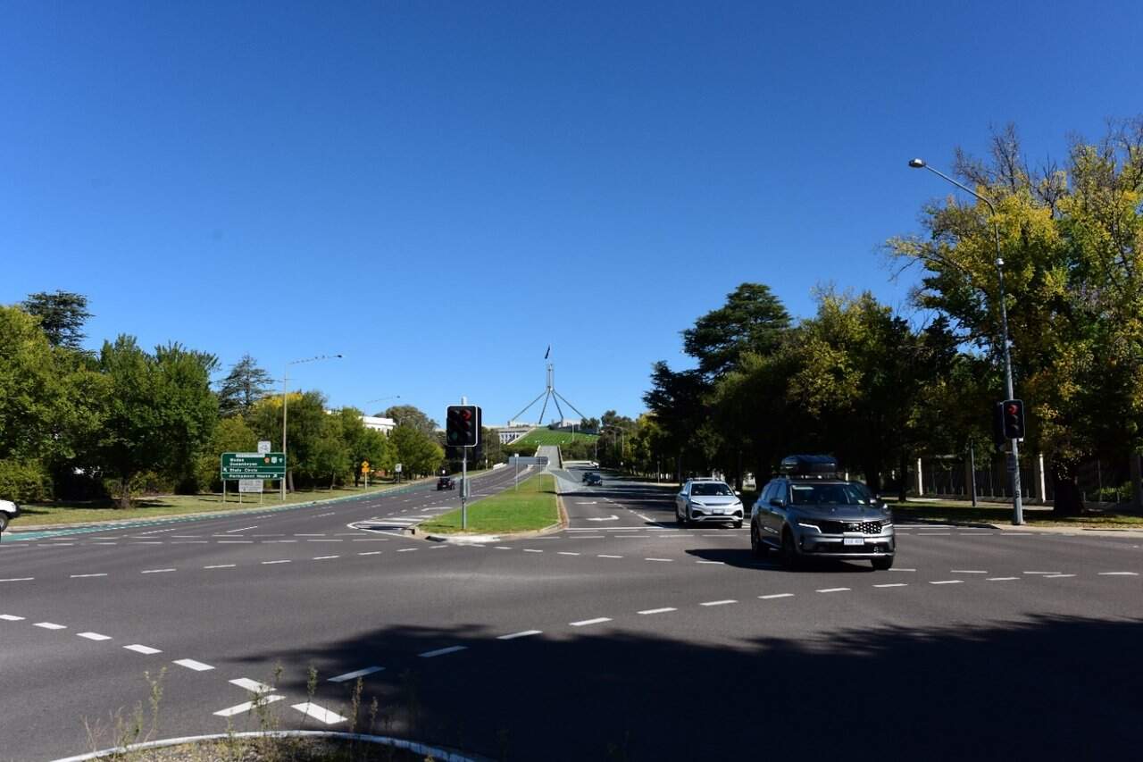
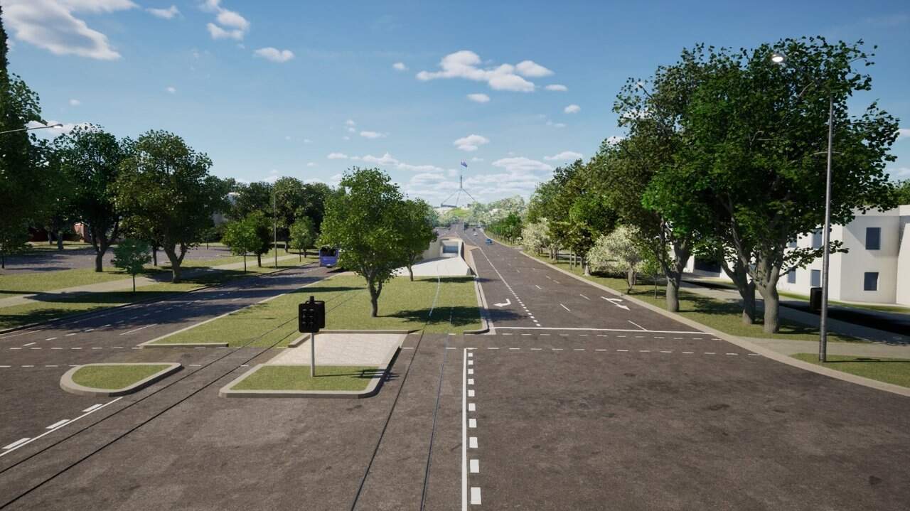
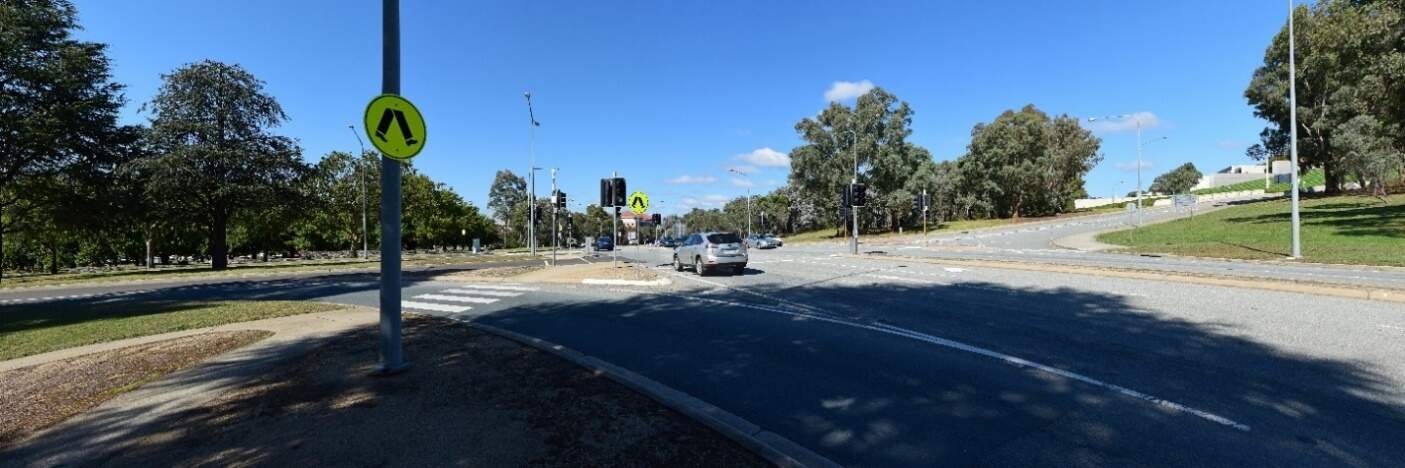
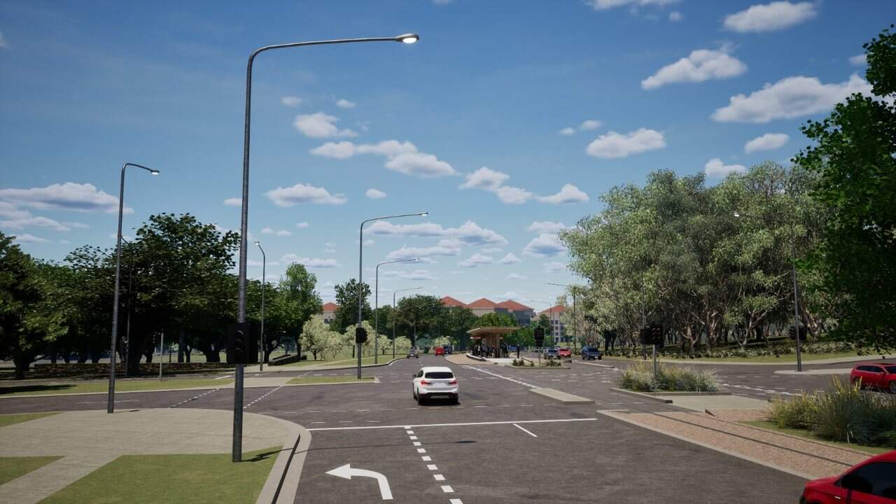
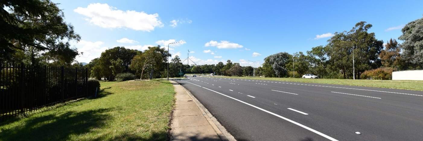
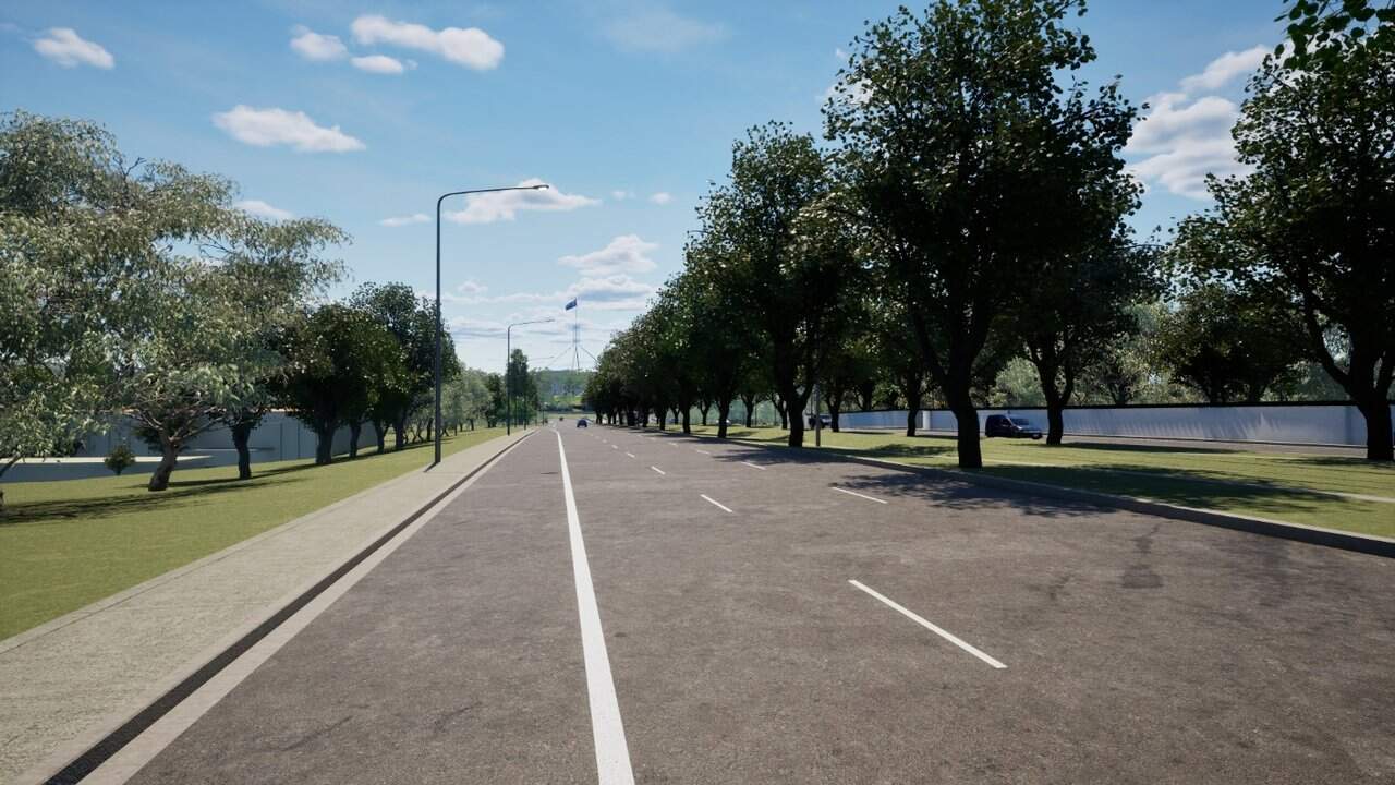
Night-time visual impact assessment
While the Project would introduce additional lighting, including expanded areas of street lighting and LRV headlights along the tracks, the light rail corridor would have similar light levels to the existing streetscapes of State Circle and Adelaide Avenue which fall within the A3: Medium district brightness zone and Commonwealth Avenue (State Circle East alignment option only) which falls within the A4: High district brightness zone. However, light rail stops would introduce additional lighting to prioritise passenger safety at night. Light spill from these stops would affect adjacent land uses including:
- The Commonwealth heritage listed York Park North Tree Plantation (State Circle East alignment option)
- Commercial properties on State Circle at Sydney Avenue (State Circle East alignment option)
- Residential properties on State Circle at Melbourne Avenue (both alignment options)
- Adjacent woodland buffer planting areas of Capital Hill (both alignment options).
The covered section and light rail bridge over State Circle would introduce lighting elements within the precinct. Sensor activated lighting within the covered section would be part of the lighting strategy to reduce visual impact and discourage unwanted access by pedestrians or vehicles, such that lighting for the track is only activated when a LRV approaches.
Additional street-level lighting would be seen in the context of the existing lit transport corridors. However, due to the frequency of LRVs and additional lighting corridor, there would be a noticeable reduction in visual amenity at night from particularly residential properties facing State Circle.
For these reasons, the visual impact during operation at night would be minor adverse.
13.6.4 Precinct specific management and mitigation measures
Environmental management for this Project is detailed in Chapter 21 (Environmental management and mitigation measures). This includes construction and operational mitigation measures to manage landscape character and visual amenity, that are applicable to the Project as a whole.
No further precinct-specific measures have been identified for landscape character and visual amenity impacts at the Parliament House precinct.
The Public Domain Master Plan (Appendix I) identifies design principles and guidance for the Project. These principles would be applied to the Project through ongoing design development and would contribute to management and mitigation of landscape and visual impacts of the Project during operation.
13.7 Socioeconomic
This section provides an assessment of the potential socioeconomic impacts associated with the construction and operation of the Project within the Parliament House precinct. Further detail on the socioeconomic assessment is provided in Technical Report 6 - Socioeconomic. The methodology applied for this assessment is summarised in Chapter 10 (Assessment methodologies) and discussed in detail in Section 4 of Technical Report 6 - Socioeconomic.
Some socioeconomic impacts would be applicable to the Project as a whole (including this precinct) and are assessed in Section 11.7 of Chapter 11 (Project-wide issues).
13.7.1 Existing environment
Community characteristics
The social area of influence encompasses the geographical extent of a project's potential impacts on people, including how positive and negative impacts may be reasonably perceived or experienced by different people. The area of social influence forms the study area for this assessment and is shown on Figure 11-1 in Section 11.7.
The assessment has considered the following in defining the social area of influence for the Project:
- Precincts: this term is applied to a geographic area designated for the purposes of the Project where people are most likely to experience both construction and operational socioeconomic impacts from the Project, or a level of direct impact. Statistical Area level 2 (SA2) areas have been selected for each precinct to represent the community where direct socioeconomic impacts could potentially occur. The Parliament House precinct spans the following SA2s:
- Parkes North SA2
- Parkes South SA2
- Corridor: this term is applied through the assessment where the spatial extent of socioeconomic impacts on people is generally broader than the precinct area. Statistical Area level 3 (SA3) areas have been selected to represent the corridor, including:
- South Canberra SA3
- Woden Valley SA3
- ACT: in some instances, the social area of influence is extended to a 'region' to reflect broader potential socioeconomic impacts, compared to the 'corridor'. This assessment refers to the 'region' as the Australian Capital Territory (ACT).
The characteristics of the communities within the area of social influence is described as the social baseline. The social baseline has been analysed by considering the human, social, economic, physical, and natural capital present around each precinct, the corridor, and the ACT. Capital refers to various forms of resources that contribute to the well-being, sustainability, and resilience of a community.
The Parliament House precinct is primarily a central administrative and ceremonial space. Its primary function is to house significant government buildings, monuments, and open spaces. While there are some nearby dwellings in surrounding precincts, the precinct itself does not have a substantial residential population. As such, residential populations in SA2s relevant to the precinct were unable to be quantified by the Australian Bureau of Statistics in the 2021 census. It is noted that residential properties on State Circle are captured in the relevant Inner South SA2.
The Parliament House precinct is an important site for democratic expression, hosting rallies, protests, and memorials at Federation Mall, which is also an attractor for tourists. On average, there are four rallies, protests, or memorials per year, with peak visitation typically occurring in March.
Parliament House serves as a central hub for government operations and political activity, attracting a wide range of workers, officials, and professionals. Its status as a national symbol and the site of key political events also draws numerous domestic and international tourists.
Section 11.7 of Chapter 11 (Project-wide issues) provides a summary of community capitals for the corridor and the ACT. The South Canberra SA3 has been analysed as part of the corridor and provides insight into people most likely to be transient to the precinct (e.g. visiting or working in the precinct).
Social infrastructure
Social infrastructure comprises social services or facilities that are used for the physical, social, cultural, or intellectual development or welfare of the community. Social infrastructure within a 500 m buffer of the Parliament House precinct's area of social influence is shown on Figure 13-30.
The precinct includes government institutions, community parks, and gardens.
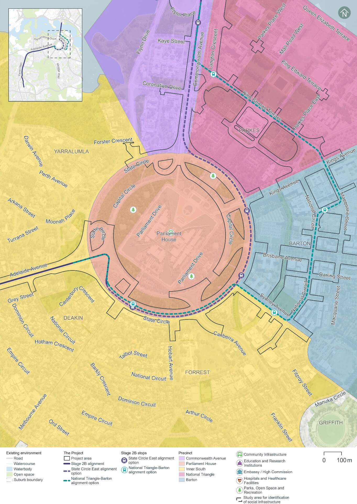
13.7.2 Potential impacts - construction
A summary of the potential socioeconomic impacts of the Project's construction for those working in, visiting, or living in proximity to the Parliament House precinct is provided in Table 13-42. Construction-phase socioeconomic impacts within the Parliament House precinct would be common to both alignment options.
The significance of each impact has been evaluated taking into account its likelihood and magnitude, both before and after the implementation of proposed mitigation measures. The assessment approach is described further in Chapter 10 (Assessment methodologies) and Section 4 of Technical Report 6 - Socioeconomic.
The people most likely to be affected by change in this precinct would include those living in nearby residential premises, local workers, visitors to Parliament House, and those attending events or cultural activities.
Residents, workers, and students provided feedback via online surveys and other consultation activities (which are described in Chapter 4 (Stakeholder and community consultation)), indicating that construction noise and vibration is a key community concern, as well as potential traffic impacts causing disruptions to their commute. Participants indicated concern over disturbance to workers from construction during business hours, and potential for annoyance to residences outside of business hours.
In terms of landscape and heritage, several participants highlighted the importance of maintaining an attractive landscape during construction given the national significance of the Parliament House area for both workers and tourists.
Although some construction impacts remain rated as medium even after mitigation, impacts are predominantly temporary and would be minimised through the implementation of the mitigation measures identified in Table 13-42 and Chapter 21 (Environmental management and mitigation measures).
| Description of impact | Relevant alignment option | Pre-mitigation impact (likelihood/ magnitude) | Mitigation approach | Mitigated impact (likelihood/ magnitude) |
|---|---|---|---|---|
|
Health and wellbeing Disruptions to local amenity during construction, potentially leading to a decline in health and wellbeing affecting workers, visitors, and accommodation providers. This may particularly affect people with disabilities or chronic illnesses. Changes to local amenity to this precinct are assessed further in Section 13.1.4 Section 13.3, and Section 13.6, (in relation to traffic, noise and vibration, and visual impacts, respectively). |
Both |
High |
|
Medium |
|
Disruptions to the road network and parking - impact to road users Temporary impact to road users due to temporary traffic changes, including during major events. This would include temporary road closures and restrictions of some turning movements, introduction of heavy vehicle traffic associated with construction, and temporary loss of on-street parking spaces, which would change how people travel through and use the area and result in minor travel time increases. Further detail on transport and access impacts within this precinct is provided in Section 13.1.4 . |
Both |
Very high |
|
High |
|
Disruptions to the road network and parking - impacts to accessibility for businesses, services, and workplaces Decline in accessibility to business and services due to temporary loss of some on-street parking on State Circle, Melbourne Avenue and Hobart Avenue during construction, affecting visitors, employees and customers. Further detail on transport and access impacts within this precinct is provided in Section 13.1.4. |
Both |
Very high |
High |
|
|
Visual landscape and heritage Changes to the aesthetic value of the area and impact to heritage items of significance adjacent to the Project area, potentially affecting connection to place, shared histories, and the future of their community, including Parliament House. Further detail on landscape and visual impacts in this precinct is provided in Section 13.6. Further detail on impacts to historic heritage in this precinct is provided in Section 13.5 and impacts to First Nations heritage is provided in Section 11.4 of Chapter 11 (Project-wide issues). |
Both |
High (likely/ moderate) |
|
Medium (possible/ moderate) |
13.7.3 Potential impacts - operation
A summary of the potential socioeconomic impacts of operation of the Project for those living, working in, or visiting the Parliament House precinct is provided in Table 13-43. Socioeconomic impacts within the Parliament House precinct would be common to both alignment options, unless otherwise noted.
Table 13-43 identifies socioeconomic impacts and evaluates the likelihood and magnitude of these impacts before and after the implementation of proposed mitigation measures. Where the impact is beneficial, this has been noted in Table 13-43. For beneficial impacts, measures which would enhance Project benefits have also been considered. The assessment approach is described further in Chapter 10 (Assessment methodologies) and Section 4 of Technical Report 6 - Socioeconomic.
Participants in the online YourSay survey from this precinct (refer to Chapter 4 (Stakeholder and community consultation)) indicated light rail operational benefits for the precinct including support for providing an alternative to private vehicle use, and for potential visual benefits of light rail compared to cars or buses. Transport-related socioeconomic benefits would apply to people across the light rail corridor and are considered further in Chapter 11 (Project-wide issues).
| Description of impact | Relevant alignment option | Pre-mitigation impact (likelihood/ magnitude) | Mitigation approach | Mitigated impact (likelihood/ magnitude) |
|---|---|---|---|---|
|
Landscape and visual changes Change to community character due to permanent changes to local visual landscape. The addition of light rail infrastructure, including three stops, along State Circle and removal of trees would result in potential adverse changes. This change may impact people's overall experience and connection to the area. Further detail on landscape and visual impacts in this precinct is provided in Section 13.6. |
State Circle East alignment option |
High (likely/ moderate) |
|
Medium (likely/minor) |
|
Landscape and visual changes Change to community character due to permanent changes to local visual landscape. The addition of light rail infrastructure along about a third of State Circle and the northern end of Adelaide Avenue and removal of trees would result in potential adverse changes, although the use of green track would partly mitigate the visual impact. This change may impact people's overall experience and connection to the area. Further detail on landscape and visual impacts in this precinct is provided in Section 13.6. |
National Triangle-Barton alignment option |
Medium (possible/ moderate) |
Low (possible/minor) |
|
|
Disruptions to the road network and parking - impacts to accessibility for businesses, services, and workplaces Some decline in accessibility to business and services due to permanent loss of around 30 kerbside spaces and changes to property access. Impacts to the road network and parking associated with each alignment option are detailed in Section 13.1.4 . |
State Circle East alignment option |
Low |
|
Low |
|
Disruptions to the road network and parking - impacts to accessibility for businesses, services, and workplaces A decline in accessibility to business and services is unlikely as current parking spaces and property access would be maintained. Impacts to the road network and parking associated with each alignment option are detailed in Section 13.1.4. |
National Triangle-Barton alignment option |
Very low |
Negligible |
|
|
Access and mobility Enhanced accessibility and safety for pedestrians and cyclists, including those with mobility constraints, through safety-related changes to active travel (e.g. improved crossing facilities). Refer to Section 5.8 of Chapter 6 (Project description) for further detail on active travel arrangements. |
Both |
Beneficial |
|
Beneficial |
|
Operational noise Potential decline in social amenity and impact on amenity for sensitive receivers e.g. the Presbyterian Church of St Andrew services due to operational rail noise impacts. Refer to Section 13.3 for further detail on operational rail noise impacts in this precinct. |
State Circle East alignment option |
Low (possible/ minor) |
|
Medium (possible/ moderate) |
13.7.4 Precinct-specific management and mitigation measures
Environmental management for this Project is detailed in Chapter 21 (Environmental management and mitigation measures). This includes construction and operational mitigation measures to manage noise and vibration impacts, that are applicable to the Project as a whole.
No further precinct-specific measures have been identified for socioeconomic impacts within the Parliament House precinct.