Frequently asked questions.
We have completed the first stage of road widening on Stacey Street by providing an additional lane for southbound motorists between Macauley Avenue and Stanley Street. We have also extended the existing dual right turn bay on Stacey Street for road users turning right into Macauley Avenue.
After considering comments from the community and key stakeholders about the loss of open space and the removal of trees at Stevens Reserve, we have decided not to proceed with the proposed road widening on Stanley Street, Bankstown.
This means, although we can’t create an additional right turning lane on Stanley Street, we can now move the delivery of all other improvements into the second stage of construction, providing more immediate congestion and safety benefits for local residents.
We have also amended our design to relocate the pedestrian crossing at the intersection of Stacey Street, Macauley Avenue and Fairford Road from the southern leg of the intersection to the northern side. This will prioritise the safety of pedestrians, ensuring they can cross the road without needing to wait at the crossing island.
For more information on the changes to the project take a look at our project webpage at rms.nsw.gov.au/sfb
Construction of Stage 2 of the improvements will begin in the second half of 2019, and will be completed by mid 2021. More information on the construction schedule for the remainder of the project will be provided as the project progresses.
Covering the open drain on Stacey Street was investigated and considered as part of this project. A number of possible solutions were discussed with key stakeholders including Sydney Water and the City of Canterbury Bankstown. Due to the constraints of the existing drain structure, covering the drain completely or partially would impact the effective flood management of the area. For this reason it was not able to be covered further as part of this project.
Roads and Maritime investigated the use of the pedestrian footbridge across the open drain on Stacey Street due to safety concerns. Pedestrian volumes were measured during morning and afternoon peak periods on a weekday and across a 12-hour period on the weekend.
A total of 17 pedestrians used the mid-block crossing during the morning peak period and 13 during the afternoon peak period during the weekday. A total of 40 pedestrians used the pedestrian footbridge during the 12-hour period on the weekend, with a maximum of eight pedestrians per hour.
Due to the low volumes of use and safety concerns raised by the community, we closed the access to the footbridge as part of our project to improve Stacey Street during the first stage of construction. The footbridge will be removed from the open drain on Stacey Street as part of work in the second stage. Alternative pedestrian access across Stacey Street is available at the intersections of Stanley Street and Macauley Avenue.
During the course of completing the improvements, access to some driveways may be impacted for construction and safety purposes. Roads and Maritime will be in contact with these impacted residents at the appropriate time to discuss alternative solutions. On the completion of the project, all driveway access will be returned to existing conditions.
A review of environmental factors was carried out as part of this project’s assessment. Vegetation within the project area consists of mainly planted trees and shrubs and does not include any native species or threatened ecological communities.
Pinch points are intersections or short lengths of road at which a bottleneck exists. These bottlenecks can occur from increased vehicle volumes on the network and growth in the area. Bottlenecks cause a build-up of vehicles and can result in travel delays for motorists travelling along the road network.
In February 2015, the NSW Government committed $300 million to address critical pinch points along the A1, A3 and A6 routes south of the M5 Motorway. The program focuses on short to medium term solutions to improve travel time and reliability for all road users. To find out more about the Gateway to the South Pinch Point Program please visit rms.nsw.gov.au/g2s
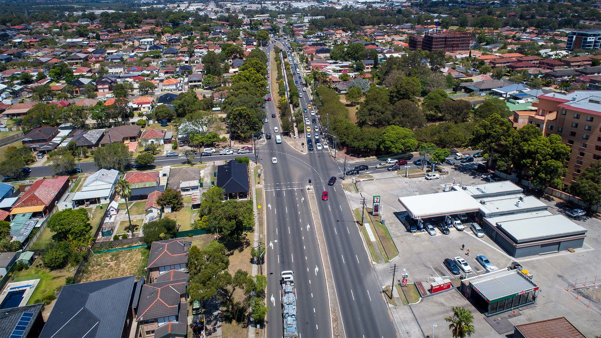

Stacey Street road widening
Drag the slider from the left to right to compare the existing road layout to the designed road layout.
We're pleased to advise our first stage of construction is completed. We have widened the southbound lanes of Stacey Street between Macauley Avenue and Stanley Street to provide three lanes in the southbound direction for road users. We have also extended the existing dual right turn bay on Stacey Street for road users travelling right into Macauley Avenue.
This work will allow road users to move quicker through the road corridor, connecting you to southern Sydney, Sydney CBD and Sydney's west.
Share this: Share on Facebook Tweet on Twitter

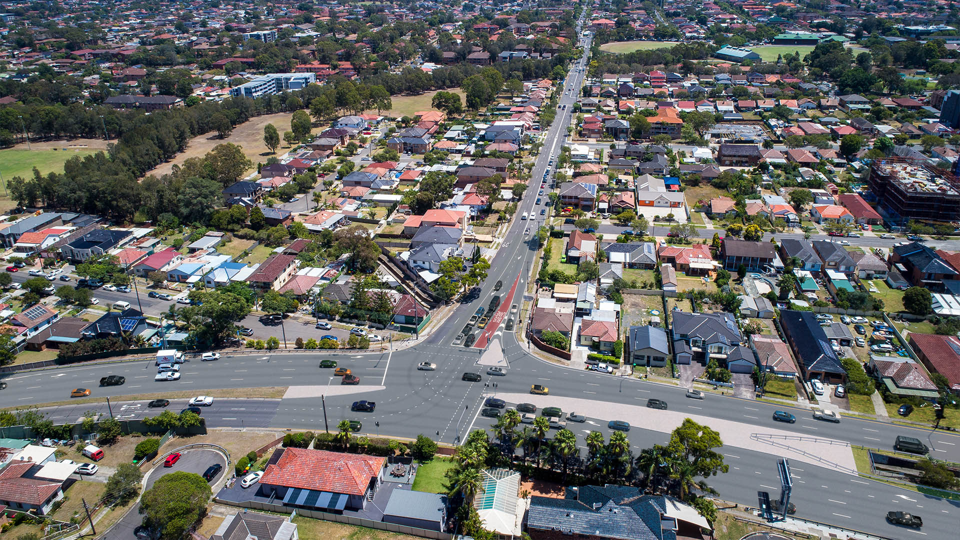
Intersection improvements at Stacey Street,
Fairford Road and Macauley Avenue
Drag the slider from the left to right to compare the existing road layout to the designed road layout.
We are widening the northbound lanes of Stacey Street between Macauley Avenue and Stanley Street to provide three lanes in the northbound direction for road users. We are also improving the Stacey Street and Macauley Avenue intersection to provide a quicker journey for a large number of road users turning right from Macauley Avenue onto Fairford Road.
Work includes:
- changing Macauley Avenue to include double right turning lanes for road users travelling southbound onto Fairford Road and a dedicated right turn lane for buses
- widening Fairford Road to provide three northbound lanes and a left turn lane at the intersection of Macauley Avenue.
Share this: Share on Facebook Tweet on Twitter

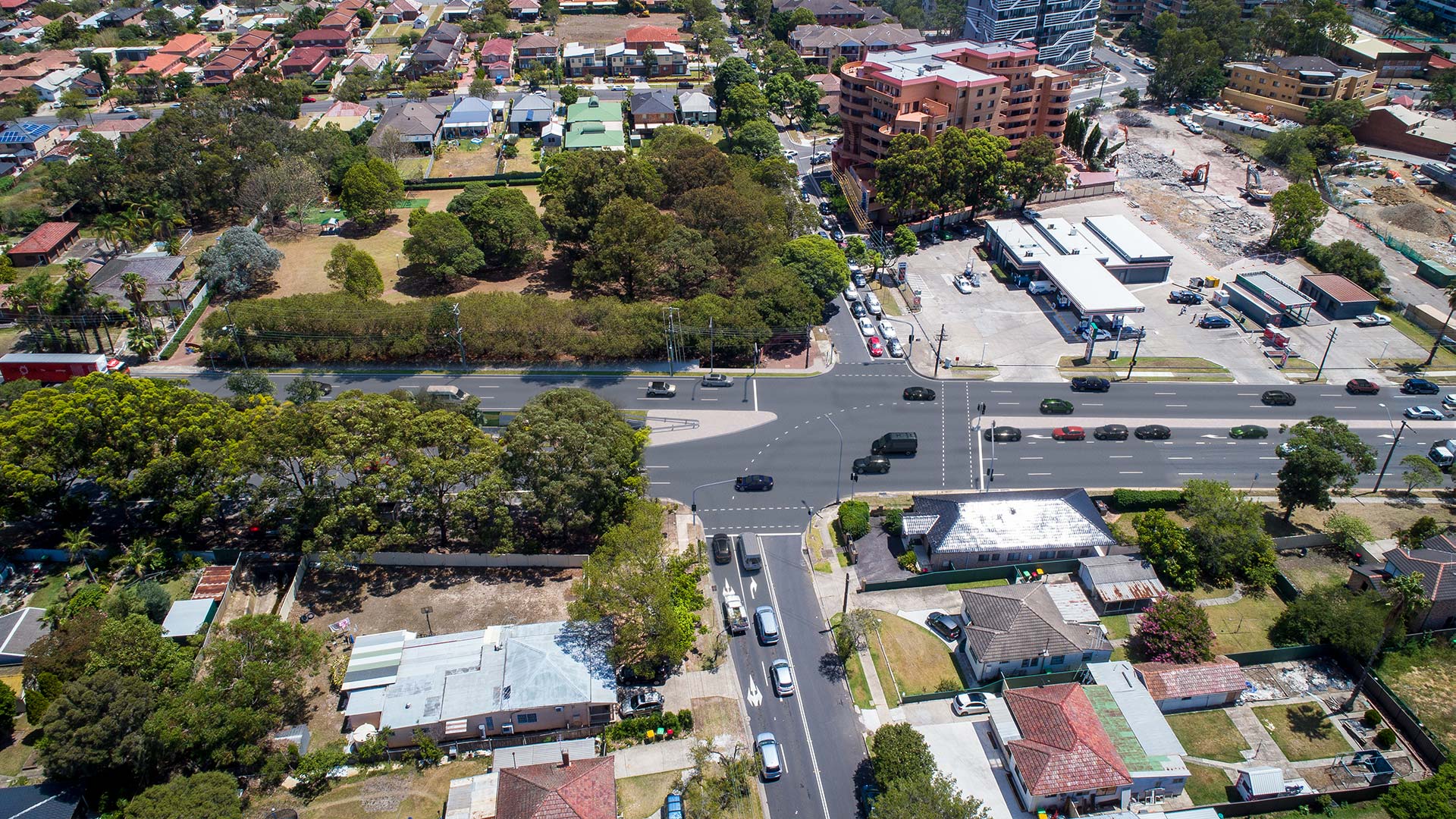
Intersection improvements at Stacey Street, Stanley Street and Salvia Avenue
Drag the slider from the left to right to compare the existing road layout to the designed road layout.
After considering comments from the community and key stakeholders about the loss of open space and the removal of trees at Stevens Reserve, we have decided not to proceed with the proposed road widening on Stanley Street, Bankstown.
This means we won't create an additional right turning lane on Stanley Street, we can now move the delivery of all other improvements into the second stage of construction, providing more immediate congestion and safety benefits for local residents.
During second stage, we will extend the right turn bay on Stacey Street southbound into Stanley Street so more motorists can queue to safely turn.
We will install new pedestrian crossing lights at Salvia Avenue near Stacey Street.
Share this: Share on Facebook Tweet on Twitter
Closed footbridge over the storm water culvert on Stacey Street directly opposite Petunia Avenue
Transport for NSW investigated the use of the pedestrian footbridge across the open drain on Stacey Street due to safety concerns. Pedestrian volumes were measured during morning and afternoon peak periods on a weekday and across a 12-hour period on the weekend.
A total of 17 pedestrians used the mid-block crossing during the morning peak period and 13 during the afternoon peak period during the weekday. A total of 40 pedestrians used the pedestrian footbridge during the 12-hour period on the weekend, with a maximum of eight pedestrians per hour.
Due to the low volumes of use and safety concerns raised by the community, we closed the access to the footbridge as part of our project to improve Stacey Street during the first stage of construction. The footbridge will soon be removed from the open drain on Stacey Street as part of work within the second stage.
Alternative pedestrian access across Stacey Street is available at the intersections of Stanley Street and Macauley Avenue.
Stacey Street open drain
Covering the open drain on Stacey Street was investigated and considered as part of this project. A number of possible solutions were discussed with key stakeholders including Sydney Water and the City of Canterbury Bankstown.
Due to the constraints of the existing drain structure, covering the drain completely or partially would impact the effective flood management of the area. For this reason it was not able to be covered further as part of this project.
Stevens Reserve
After considering comments from the community and key stakeholders about the loss of open space and the removal of trees at Stevens Reserve, we have decided not to proceed with the proposed road widening on Stanley Street, Bankstown.
This means we won't create an additional right turning lane on Stanley Street, we can now move the delivery of all other improvements into the second stage of construction, providing more immediate congestion and safety benefits for local residents.
Speak to the project team
We will be in your local area during February to talk about the upcoming improvements to Stacey Street and Fairford Road. Our interactive map and members from the project team will be available to answer your questions at:
Bankstown Central Shopping Centre
Level 2, Stacey Street & North Terrace, Bankstown (near the food court) - MAP
Thursday 22 February 4pm – 6pm
Bankstown Central Shopping Centre
Level 2, Stacey Street & North Terrace, Bankstown (near the food court) - MAP
Saturday 24 February 10am – 1pm