NSW Government
  • Map(current)
  • Documents and media
  • Submit your comments
  • Project status
  • Share

Southern Link Road corridor

About the project

The NSW Government is proposing a new 7.5 kilometre road corridor to support the current and future employment growth in the Western Sydney Employment Area (WSEA).

Watch overview video

Ask a question

Infographic of Infographic of Infographic of Infographic of

Background

Southern Link Road is a proposed new east-west corridor that would provide an additional link between Mamre Road, Kemps Creek and Wallgrove Road, Horsley Park. Southern Link Road is expected to be around 7.5 kilometres long and provide access to the future industrial development that would create employment and economic growth in the surrounding Western Sydney area. The project will cater for regional traffic connectivity to the Western Sydney Employment Area (WSEA) and the Western Parkland City developments.

In 2014, the Department of Planning & Environment (DPE) published the Southern Link Road Network Options and Refinement report. Since then, the future land-use proposals for the surrounding area have evolved through the Mamre Road Precinct rezoning package. As a result, Transport for NSW has continued to investigate the best alignment for this important future connection.

Project Objectives

  • Provide a new road corridor within WSEA to facilitate economic growth by unlocking development and employment opportunities
  • Provide safe, reliable and efficient access for employees and freight between WSEA and the wider state road network
  • Achieve increased road capacity in the network to meet future traffic and transport demand
  • Cater for pedestrians, cyclists, and public transport in terms of accessibility, connectivity, safety and amenity.

Alternative Proposed Alignment

Considered options

Transport is continuing to plan this corridor between Mamre Road and Wallgrove Road to achieve the best possible outcome that considers future development and transport needs in the area. 

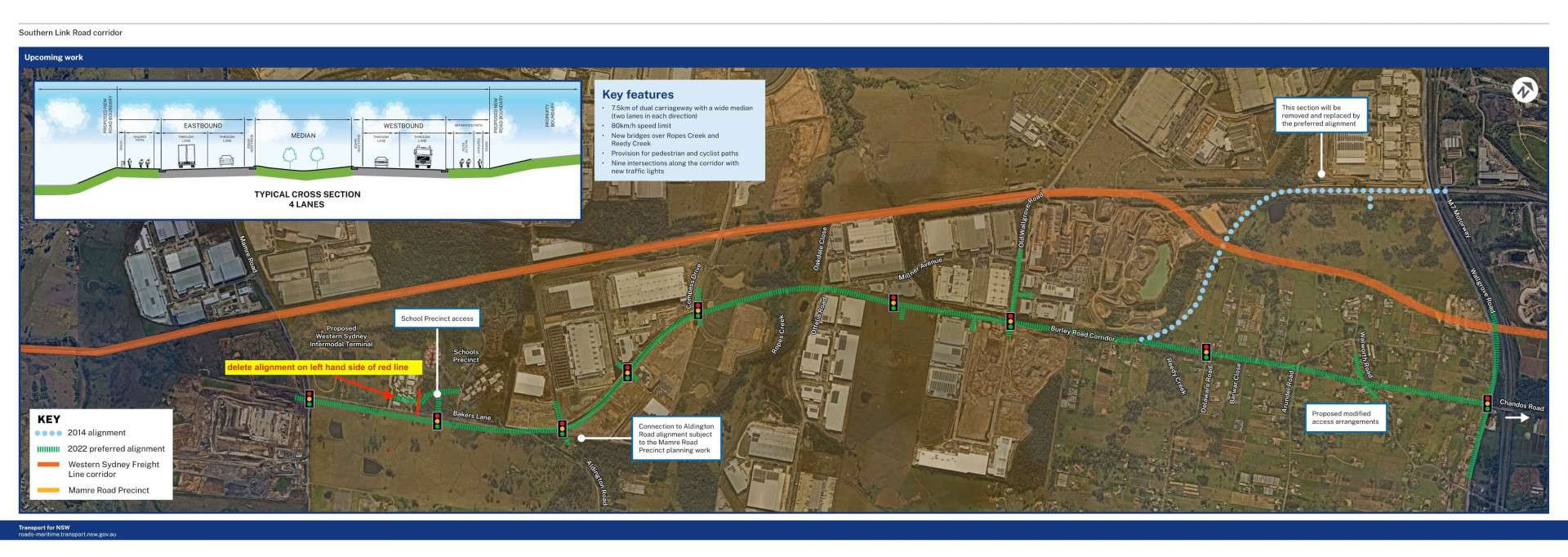
As a result of our continuing investigation and planning, we are proposing to change the route alignment at the eastern end of the corridor, around the area near Reedy Creek: 

2014 Alignment

  • Moved to the north, following the Reedy Creek corridor, towards the Water NSW Pipeline
  • Crossed through vacant land and connected to Wallgrove Road and the M7 Motorway near the Pipeline
  • Although having the road through open land will be beneficial, this alignment would clash with the confirmed Western Sydney Freight Line Corridor and need to avoid existing transmission lines.

2022 Preferred Alignment

  • Will continue directly east along the Burley Road corridor, to create a future connection with Chandos Road at Wallgrove Road
  • Will provide better future transport access and help support future development in the area

Further information on the 2022 preferred alignment and how we developed it can be found in the preferred options report, which is now available for community feedback at nswroads.work/southernlinkroad.

Key Features

  • 5km of dual carriageway with a wide median (two lanes in each direction)
  • 80km/h speed limit 
  • New bridges over Ropes Creek and Reedy Creek
  • Provision for pedestrian and cyclist paths
  • Seven new intersections and two intersection upgrades with traffic lights 

Department of Industry and Planning identified the Horsley Park/Cecil Park locality as an Urban Investigation Area in the Greater Sydney Region Plan and Western District Plan. Transport for NSW is working with DPIE, Fairfield Council, the Greater Sydney Commission (GCS), and other agencies, to plan for the future development of the area, which this road will assist.

What Happens Next?

At the end of the consultation period we will summarise comments received and publish our responses in a Community Consultation Report. The report will be available on the project website. If you submit feedback we will let you know directly when the report is available. We will continue to keep community members and other stakeholders informed as the project progresses. For more information about Southern Link Road visit our website nswroads.work/southernlinkroad.

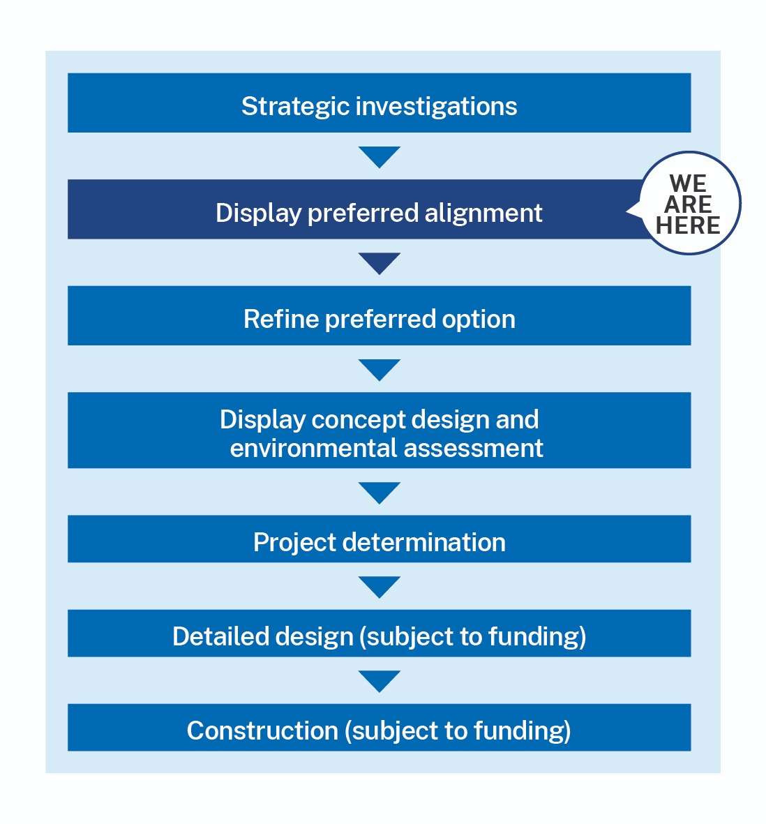
Project development process
Process timeline — we are stage 2 of 8: the Consideration of Alternative Alignment stage

Western Sydney Current Transport Projects

Western Sydney Current Transport Projects

  • Western Sydney Freight Line
  • Western Sydney Airport
  • Western Sydney Intermodal Terminal
  • M12 Motorway

Planned road upgrades

  • Elizabeth Drive
  • Archbold Road
  • Mamre Road
  • The Horsley Drive

Western Sydney Current planning proposals

Western Sydney Current Planning proposals

  • Mamre Road Precinct (Development control plan was approved in 2021)
  • Western Sydney Aerotropolis plan
  • Fairfield Rural land Urban Investigation Area

Back to map
Before/After:
Ottelia Road/Oakdale Close/
Millner Avenue Roundabout
Before/After:
Mamre Road intersection
Original proposed alignment
Alternative proposed alignment
Traffic lights
Traffic lights
Traffic lights
Traffic lights
Traffic lights
Traffic lights
Traffic lights
Traffic lights
Traffic lights
School precinct access
Connection to Aldington Road alignment subject
to the Mamre Road Precinct planning work
This section will be removed and
replaced by the preferred alignment
Proposed modified access arrangements
Typical cross section – 4 lanes
3km
See more information
Existing Design Reset

Example modal

Lorem ipsum dolor sit amet, consectetur adipisicing elit. Officia provident minus nulla, maiores recusandae dignissimos deleniti in, eum reiciendis enim velit dolores aperiam natus vitae delectus inventore culpa possimus tempore?

Lorem ipsum dolor sit amet, consectetur adipisicing elit. Officia provident minus nulla, maiores recusandae dignissimos deleniti in, eum reiciendis enim velit dolores aperiam natus vitae delectus inventore culpa possimus tempore? Lorem ipsum dolor sit, amet consectetur adipisicing elit. Porro, sed. Officiis corporis voluptatem, sint exercitationem voluptatum minima praesentium quisquam sequi repellat, laudantium rerum libero obcaecati mollitia possimus, vero numquam maxime.
2014 Alignment

  • Moved to the north, following the Reedy Creek corridor, towards the Water NSW Pipeline
  • Crossed through vacant land and connected to Wallgrove Road and the M7 Motorway near the pipeline
  • Although having the road through open land will be beneficial, this alignment would clash with the confirmed Western Sydney Freight Line Corridor and need to avoid existing transmission lines.

Alternative proposed alignment

  • Would have an improved connection with Wallgrove Road and east to Chandos Road
  • Would provide better access for future developments
  • Would impact some existing residential properties
  • © 2025 NSW Government
  • Powered by SEE
  • لغة
  • 语言
  • 語言
  • Γλώσσα
  • Linguaggio
  • 언어
  • மொழி
  • Ngôn ngữ

Before/After: Ottelia Road/Oakdale Close/ Millner Avenue Roundabout

Before/After: Mamre Road intersection

Community Information Sessions

Roads and Maritime is seeking community feedback to help inform our future works on the Link Road Corridor Study project. We will host three community information sessions where you can ask the project teams questions and seek further information about the proposed road alignment and process of selection. A formal presentation will not be given so please feel free to drop in any time at one of the following sessions:

Saturday 7 September 2019 - between 10am and 1pm
Appin Public School Hall, 97 Appin Road, Appin

Wednesday 11 September 2019 - between 5pm and 8pm
Rosemeadow Community Hall, 5 Glendower Street, Rosemeadow

Saturday 14 September 2019 - between 10am and 1pm
Information Resource Centre, Broughton Anglican College , 81–83 Menangle Road, Menangle Park

If you are unable to attend one of the information sessions, you can contact us to discuss or arrange another time that is suitable to meet. To join the
mailing list please contact the project team.

Please provide comments by 20 September 2019.

Submit your comments

Missing fields: Some required fields are missing. Please check your form.
Question already submitted: Sorry, our records indicate that you have already submitted a question.

Thank you for submitting your feedback and subscription form. You are now in our stakeholder database and will be informed of the project updates if you have selected to subscribe.

Any feedback you have provided will be considered in our next steps.

All enquiries will be responded to within five working days.

Return to portal

Reset survey

Share this

Thank you for using the Southern Link Road Corridor - portal. Transport for NSW invite you to share this information with your friends, family and colleagues via social media or email.

Share this via email

Share this on Facebook

Share this on Twitter

Share this on LinkedIn

Southern Link Road Corridor project status

Steps for the proposed Southern Link Road Corridor.

Process timeline — we are stage 2 of 8: the Consideration of Alternative Alignment stage