Insecure browser/WebGL disabled: There are security and user experience issues with your current browser. A secure modern browser with WebGL enabled is required to display interactive maps and other features.
NSW Government NSW Government

M12 Motorway WEB PORTAL

  • All documents
    Post approval documentation Assessments and EIS Community information Work activity archive
  • Map
  • Videos and images
  • Ask us a question
  • Share
Transport for NSW (RMS)

M12 Motorway

WEB PORTAL

  • Home
  • All documents
    Post approval documentationAssessments and EISCommunity informationWork activity archive
  • Map
  • Videos and images
  • Ask us a question
  • Share
  • Languages

Western Sydney International Airport interchange

Western Sydney International Airport connection at Elizabeth Drive

M12 over Elizabeth Drive near Mamre Road

M7 interchange

Elizabeth Drive connection

The Northern Road Intersection

The Northern Road Intersection

Elizabeth Drive connection

Amended M12/M7 interchange realigned Wallgrove Road

View on map

Current design: M12/M7 interchange and realigned Wallgrove Road

M12/M7 Interchange Cecil Hills

View on map

M12 Motorway virtual information room example

Lorem ipsum dolor sit amet, consectetur adipisicing elit, sed do eiusmod tempor incididunt ut labore et dolore magna aliqua. Ut enim ad minim veniam, quis nostrud exercitation ullamco laboris nisi ut aliquip ex ea commodo consequat. Duis aute irure dolor in reprehenderit in voluptate velit esse cillum dolore eu fugiat nulla pariatur. Excepteur sint occaecat cupidatat non proident, sunt in culpa qui officia deserunt mollit anim id est laborum.

Welcome to the M12 Motorway Place, Design and Landscape Plan virtual information room.

The M12 Motorway Place, Design & Landscape Plan (PDLP) public exhibition period has now ended. Our PDLP was on public display from 1 to 28 November 2021.

Your feedback is important to us and we thank you for providing your formal submissions, feedback, comments and suggestions. We will now review all of the feedback and submissions received, and where possible, make changes to the PDLP in ways where we can still meet our project requirements. All of the submissions received will be collated into a Submissions Report which we will publish on our website, nswroads.work/m12 early next year. We will also provide a copy of this along with the updated PDLP to the Department of Planning, Industry and Environment.

The final approved PDLP will be available on our website – nswroads.work/m12.

In the meantime, if you have any questions about the project pleaseΒ email us or call 1800 517 155.

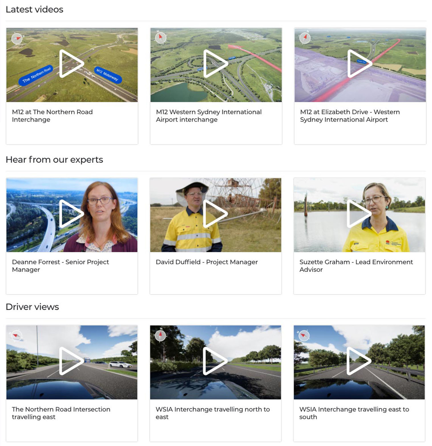
Click enter below to learn more about our PDLP and see our latest artist impressions.


Enter

Deanne Forrest - Senior Project Manager

Suzette Graham - Lead Environment Advisor

M12 - M7 interchange

David Duffield - Project Manager

M12 - M7 interchange

What are geotechnical investigations

M12 - M7 interchange

What do we look for when we do geotechnical investigations

David Duffield - Project Manager

David Duffield - Project Manager

Back to video list

What are geotechnical investigations

Back to video list

What do we look for when we do geotechnical investigations

Back to video list

James Doherty - Utilities Manager & Constructibility Advisor

Matt Pate - Project Controls Manager

Kamal Kamalarasa - Project Manager, Structures

Have Your Say

Coming soon

M12 Motorway updates

Updates delivered to your inbox

Missing fields: Some required fields are missing. Please check your form.

Thank you for subscribing.

Reset form

Make a submission

To make a submission on the Amendment Report, use the online form. All submissions received will be placed on the DPIE website.

For a video tutorial on how to make a submission on the DPIE website click here.

To watch a video tutorial about how you can subscribe to receive timely, project-related alerts click here.

If you want the Department to delete your personal information before publication, please make this clear at the top of your letter.


View the latest images and videos

Launch gallery

Aerial view north west across M7-M12 Interchange

View on map

Artist impression of Western Sydney International Airport

Launch WSIA portal

View east along The Northern Road

View on map

Proposed amendments

The proposed amendments to the project as described in the EIS are outlined below:

  • Amendments to the motorway-to-motorway interchange at the M7, including:
    • Changes to Elizabeth Drive and Cecil Road intersections, proposed exit ramps and the realignment of Wallgrove Road connection to Elizabeth Drive
    • Widening Elizabeth Drive under the M7 Motorway and approaches
  • An option to provide a new connection between the M12 Motorway and Elizabeth Drive near the M7 Motorway interchange (to be approved)
  • Two new traffic light intersections into the airport, with provisions for future connection to nearby developments

View the Amendment report

EIS submissions

The Environmental Impact Statement (EIS) for the M12 Motorway was on public exhibition in October and November 2019.

Submissions from 50 submitters were received, categorised and reviewed. Community issues are categorised in this chart.

View EIS submissions report (page 11)

Bridge over Luddenham Road

View on map

M12/M7 Interchange Cecil Hills

View on map

Cecil Road/Elizabeth Road intersection

M12 – Elizabeth Drive Connection

View on map

Elizabeth Drive connection

Shared path view north east at Airport Interchange

  • Bridge over Luddenham Road

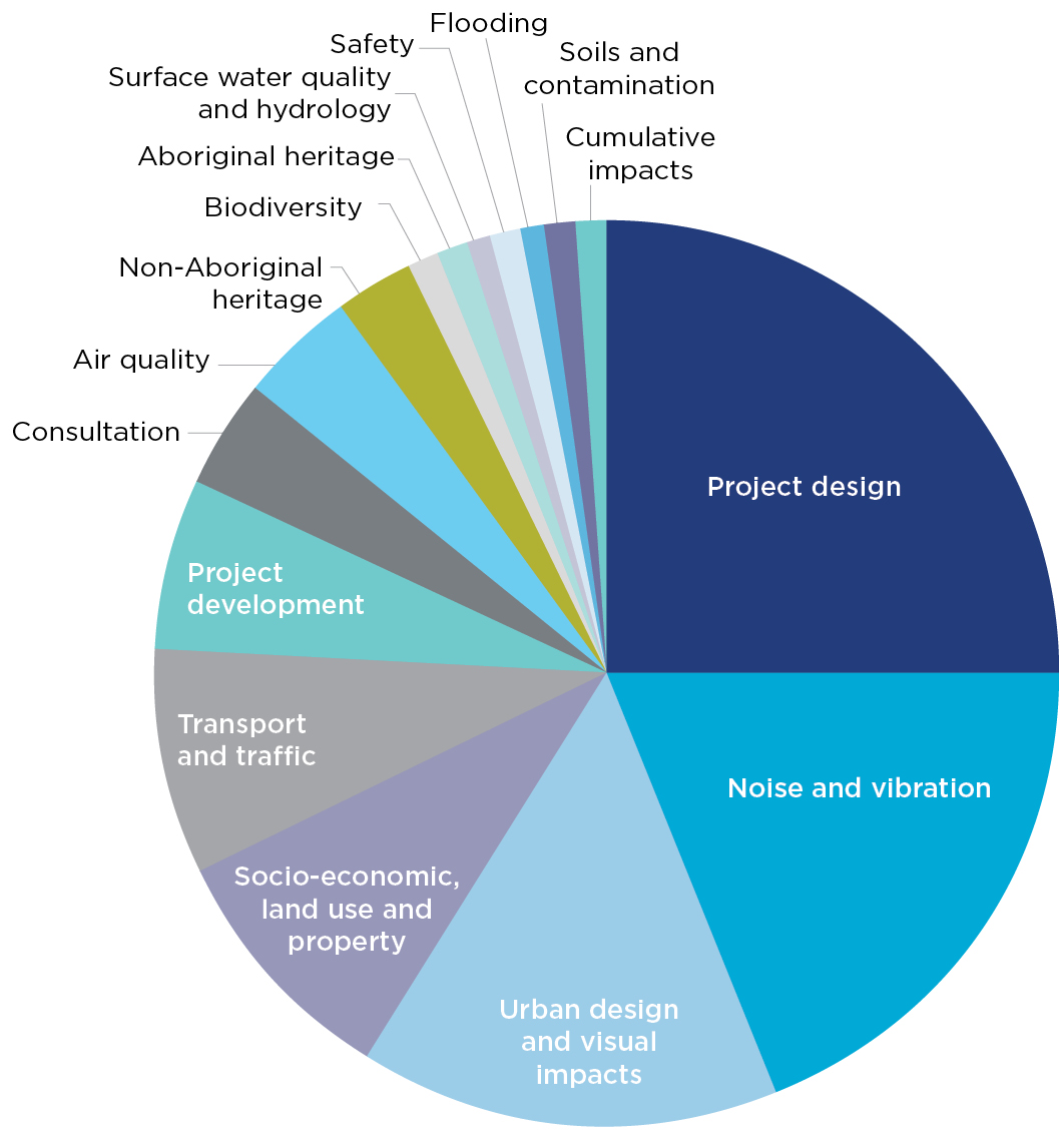
    EIS submissions captured these key issues:

    1. Lane numbers
    2. Lack of non-tolled route options
    3. Connection at The Northern Road
    4. Public transport links
    5. Cecil Hills light, visual and noise impacts
    6. Impacts to the Parklands including Wylde Mountain Bike Trail
    7. Fauna and flora impacts

Bridge over Luddenham Road

Media

Coming soon

360 Cycle way journeys

360Β° Cyclist Journey: Western Sydney International Airport Interchange
360Β° Cyclist Journey: Range Road to Elizabeth Drive travelling West

Views of the Cycleway

Cycleway at Western Sydney International Airport interchange west
Cycleway access at Elizabeth Drive
Cycleway at Western Sydney International Airport interchange east

Cycleway at Western Sydney International Airport interchange west

Back to views of the Cycleway View on map

Cycleway access at Elizabeth Drive

Back to views of the Cycleway View on map

Cycleway at Western Sydney International Airport interchange east

Back to views of the Cycleway View on map

Before/after sliders

Western Sydney International Airport interchange
Western Sydney International Airport connection at Elizabeth Drive
M12 over Elizabeth Drive near Mamre Road
M7 interchange
Elizabeth Drive connection
The Northern Road Intersection

360Β° Cyclist Journey: Western Sydney International Airport Interchange

Back to journey list View on map

360Β° Cyclist Journey: Range Road to Elizabeth Drive travelling West

Back to journey list View on map

360 Cyclist journey 3 (Project east)

Back to journey list View on map

Michael Finch - Technical Services Manager

Project maps

M12 Amended design
View on map
Biodiversity
View on map
Heritage
View on map
Traffic and transport
View on map
Noise
View on map
Water
View on map
Project history
View on map
  • M12 Amended design

    View on map
  • Biodiversity

    View on map
  • Heritage

    View on map
  • Traffic and transport

    View on map
  • Noise

    View on map
  • Water

    View on map
  • Project history

    View on map

Amended M12/M7/Elizabeth Drive interchange

View on map

Artist impression of view south from Airport access road to Elizabeth Drive Interchange and entrance to the Western Sydney International Airport precinct

Artist impression of shared user path east along the M12 Motorway

Artist impression of view east along The Northern Road

Artist impression of motorist’s view east along the M12 Motorway

Artist impression of aerial view west over Kemps Creek and nearby interpretation node

Artist impression of aerial view west over Airport Interchange

Artist impression of aerial view north east over Airport Interchange

Artist impression of motorist’s view north-west along the M12 Motorway (landscape shown is indicative only)

Artist impression of interpretation node with the Great Emu in the Sky sculpture in the background

Artist impression of interpretation node with large eucalypt leaf

Artist impression of aerial view south east across Range Road and the Western Sydney Parklands

Artist impression of interpretation node with small eucalypt leaf

Frequently asked questions

The PDLP forms part of the M12 Motorway project, and is part of the Western Sydney Infrastructure Plan (WSIP) – a $4.1 billion road investment program jointly funded by the Australian and NSW governments.

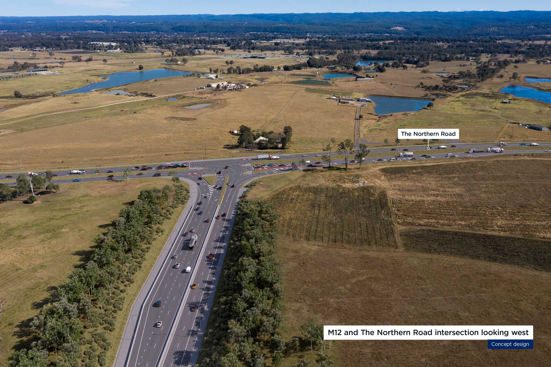
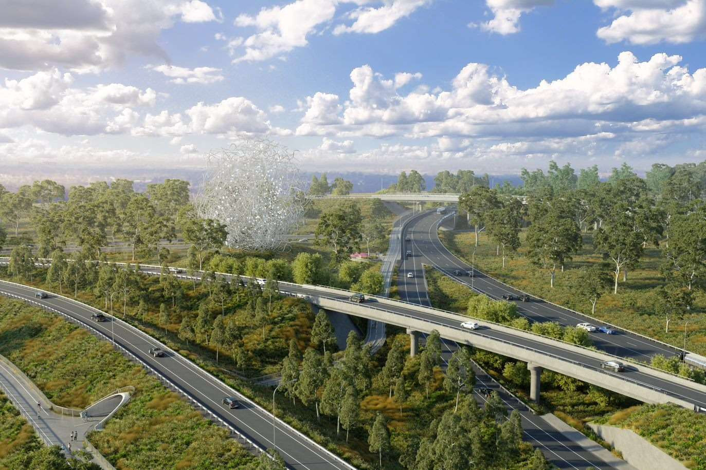
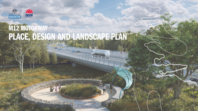
The PDLP illustrates how changes to the landscape will be designed in keeping with the cultural heritage of an area that has been part of the local Darug people and subsequent non-Aboriginal settlement. It will guide the implementation of landscape design that will be installed as part of the project including revegetation.

The PDLP includes the following information:

  • The built, natural, heritage and community context of the M12 Motorway
  • Urban design objectives, principles and standards that apply to the M12 Motorway
  • Opportunities for heritage interpretation
  • The design of key M12 Motorway elements including their form, materials and detail
  • The design of the landform and earthworks
  • Active transport infrastructure to be installed as part of the M12 Motorway
  • The location of existing vegetation, areas of vegetation to be retained and proposed planting and seeding details, including the use of local indigenous species for revegetation activities
  • Visualisations of the proposed design

The PDLP aims to solidify the urban design concept for the M12 Motorway project, using a ‘Connection to Country’ vision which will create a distinctly unique and memorable transport infrastructure connecting other parts of Sydney to the Western Parkland City.

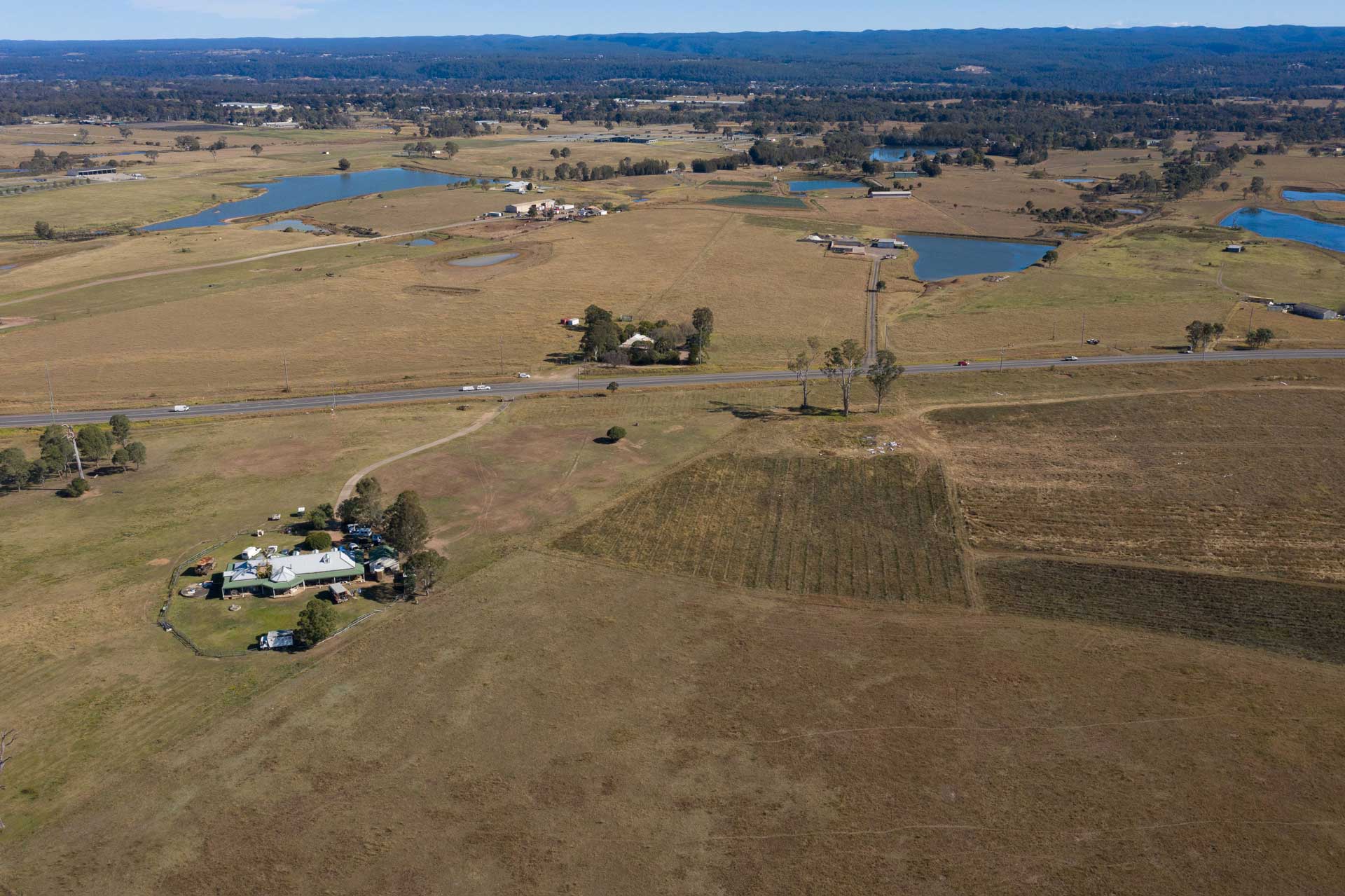
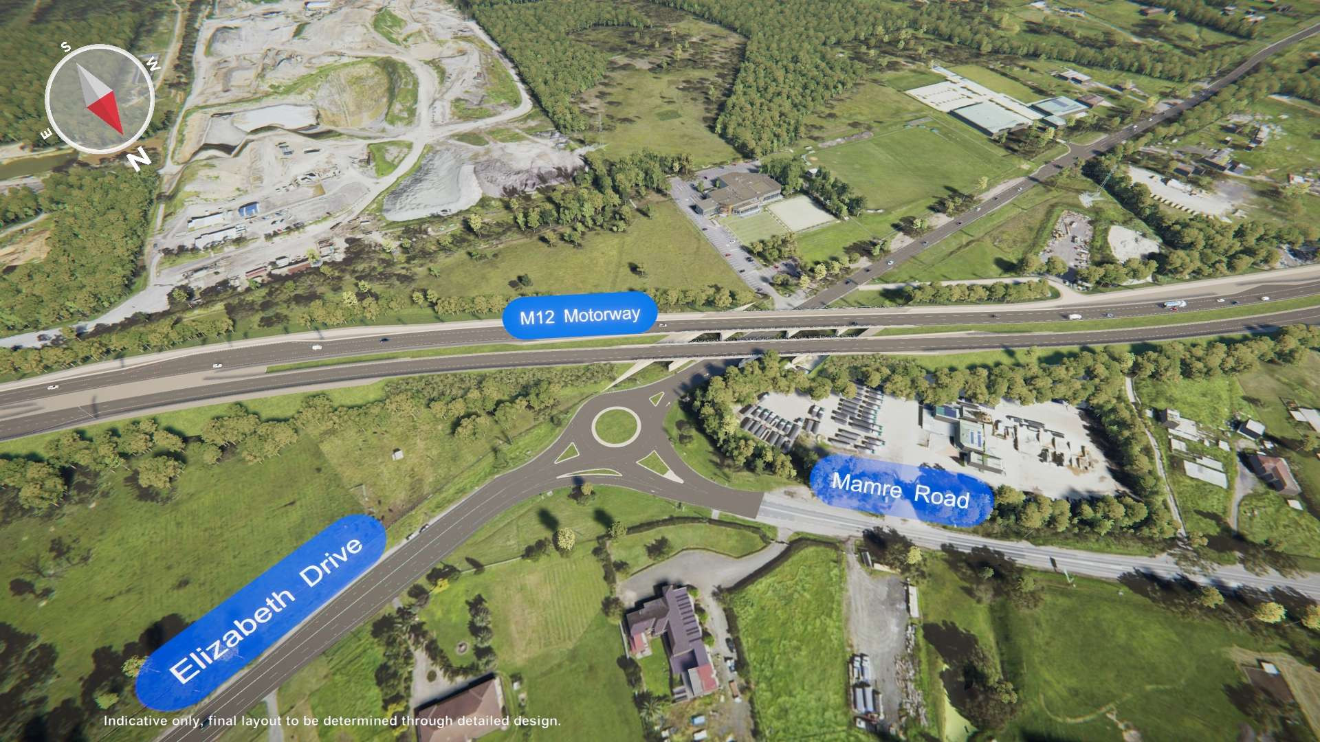
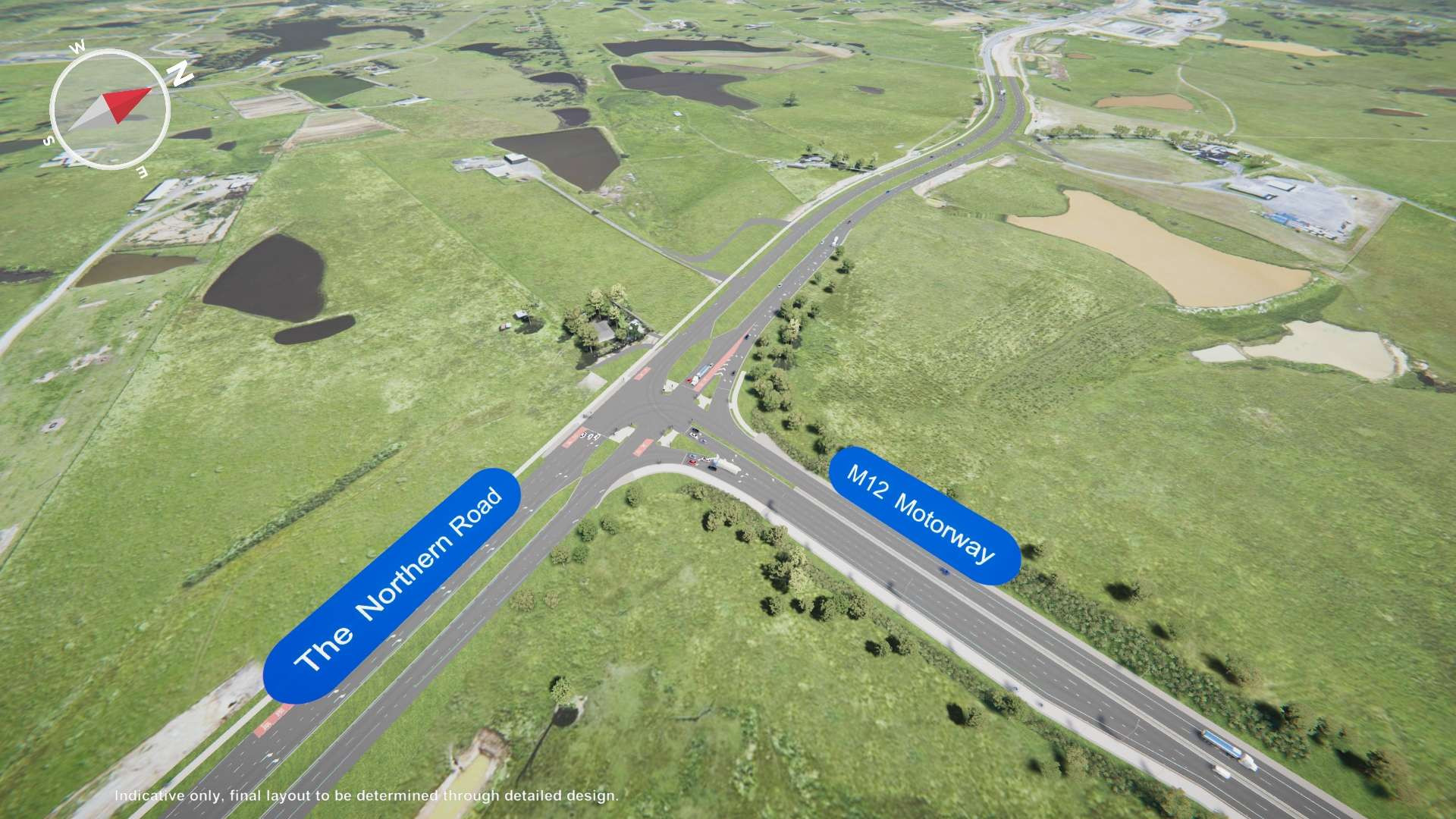
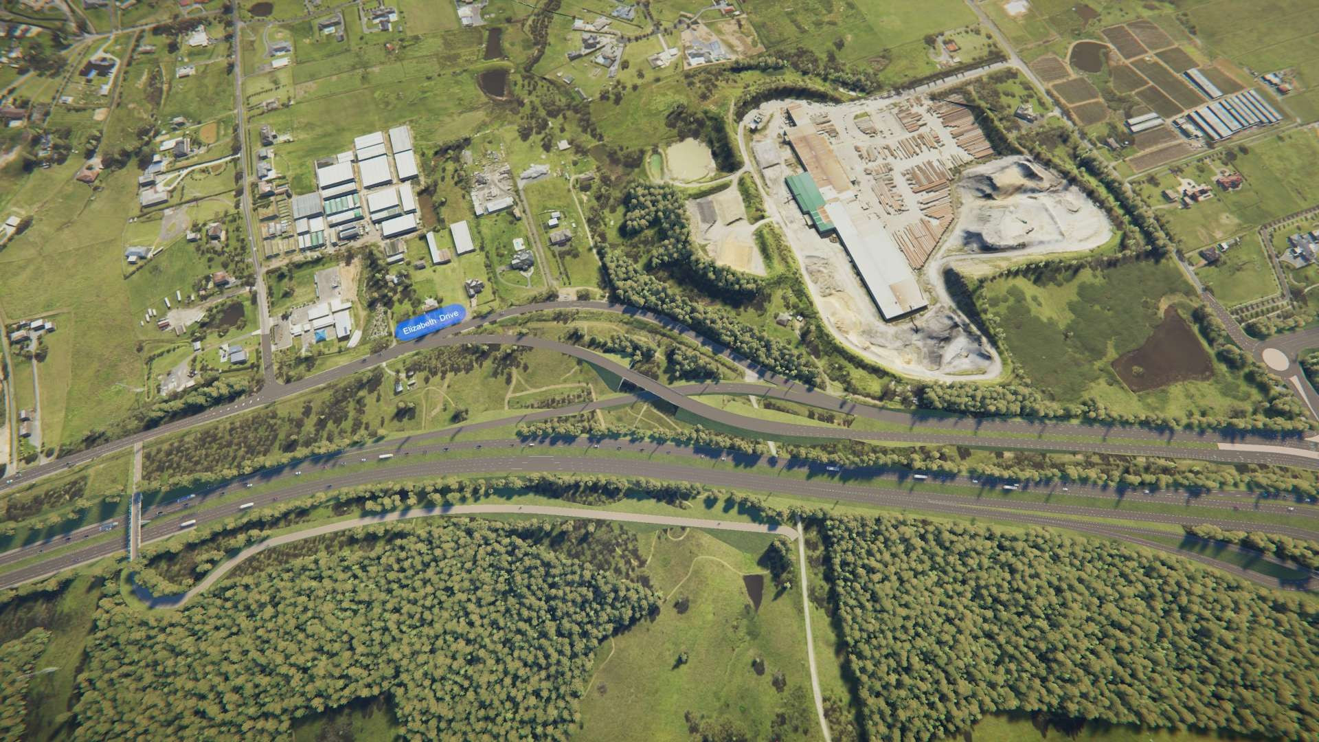
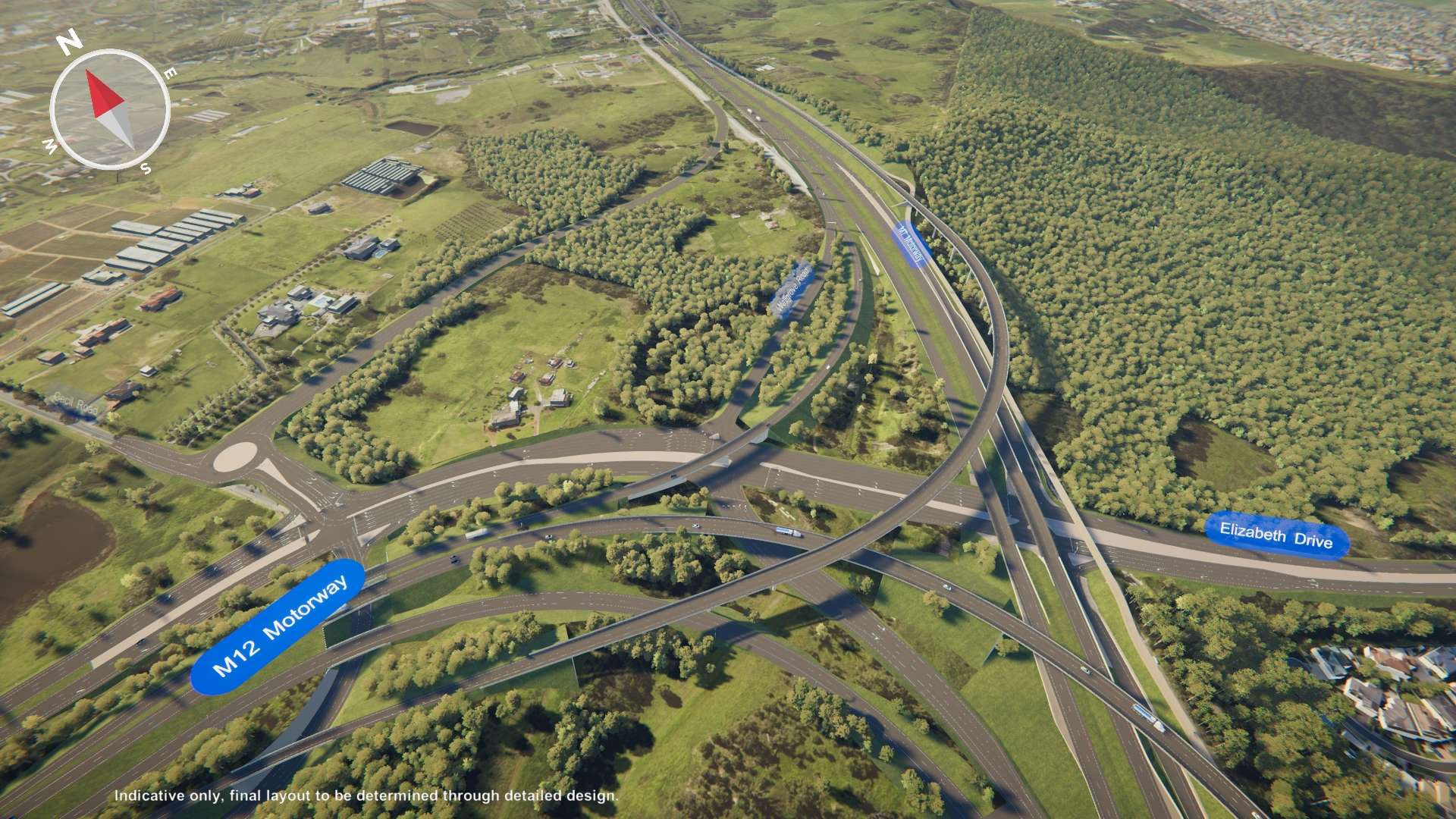
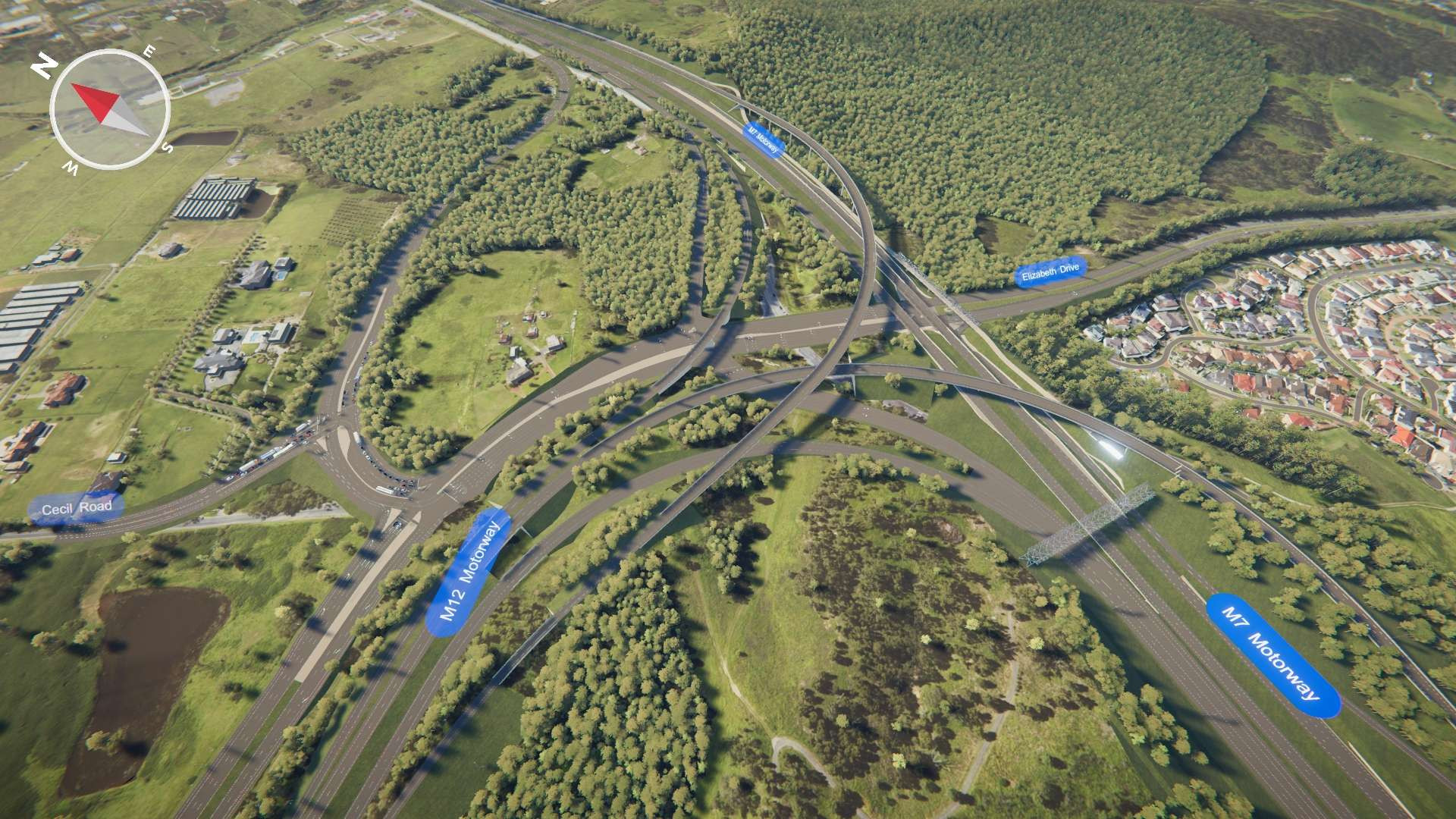
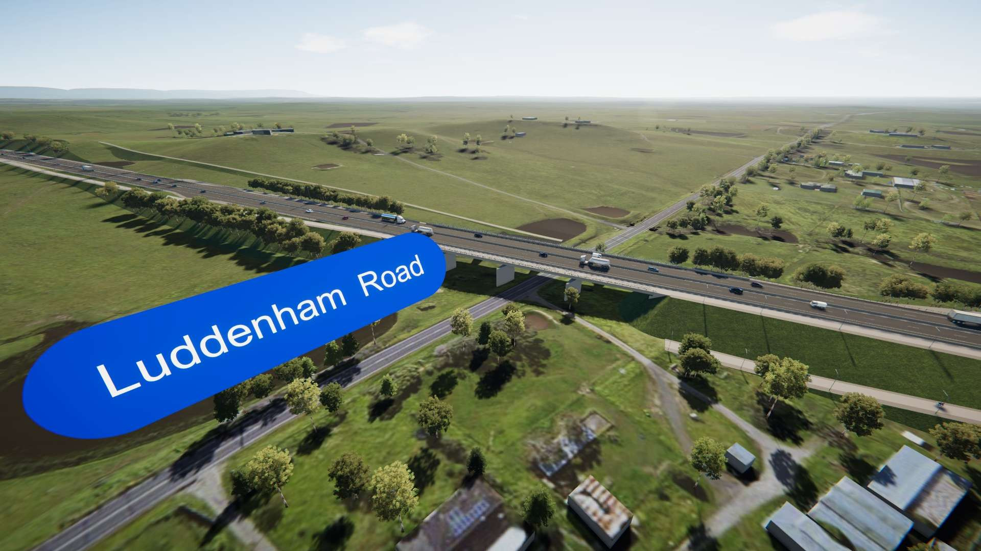
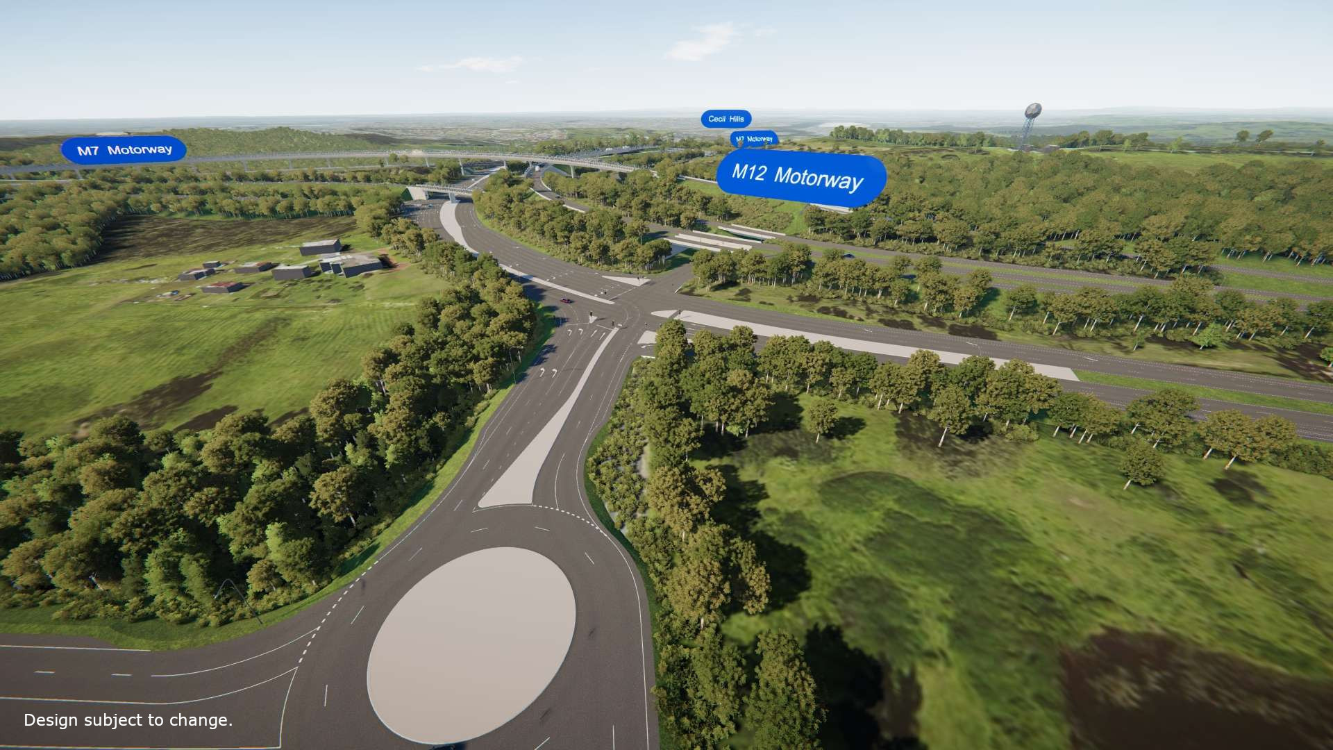
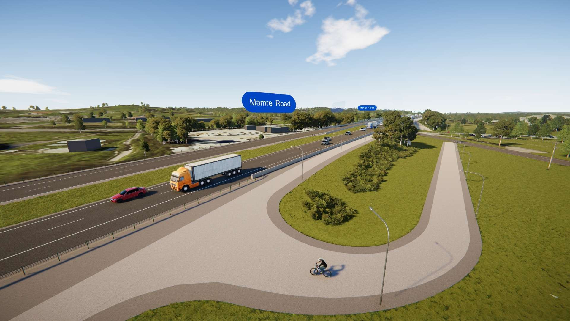
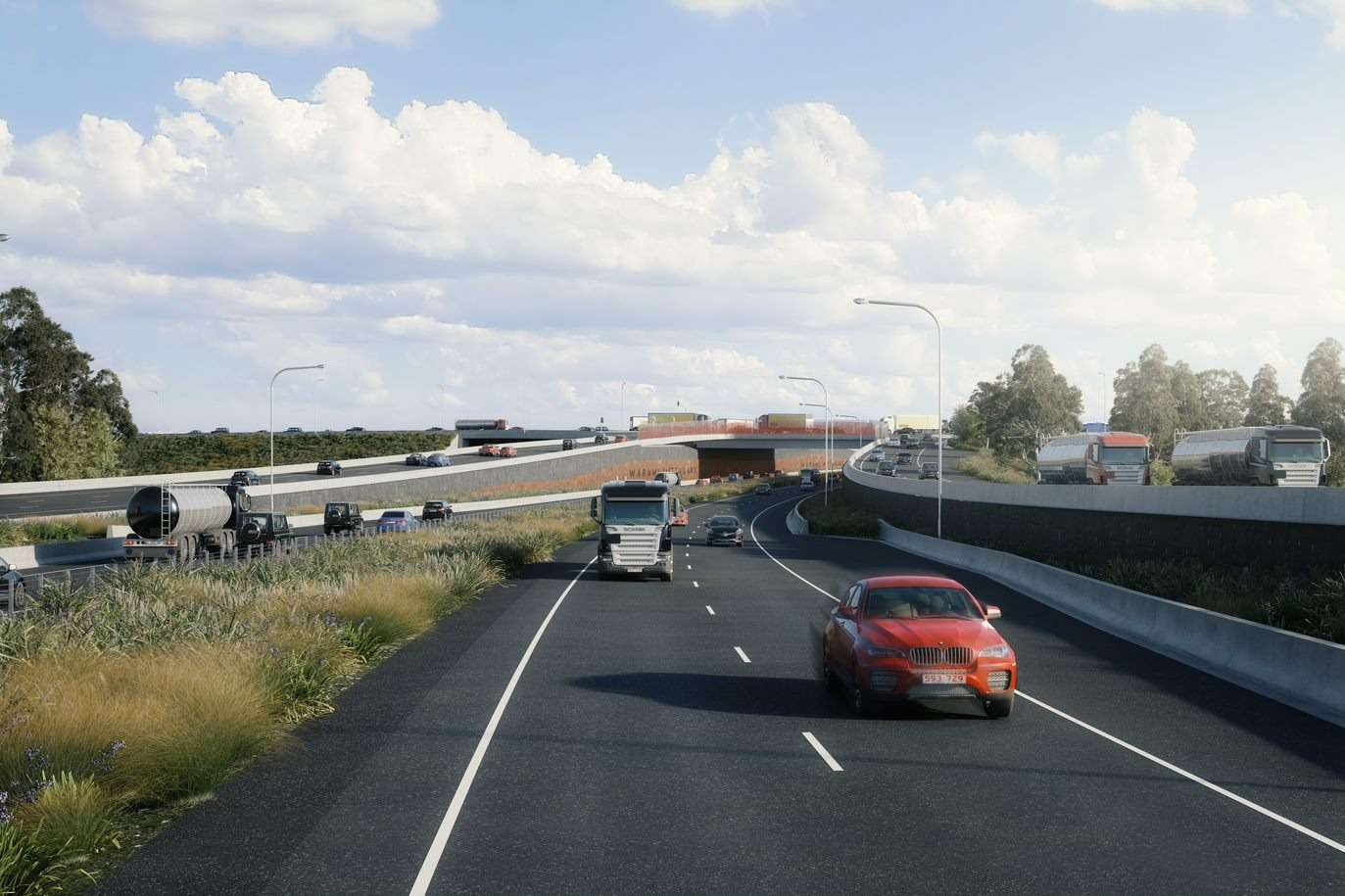
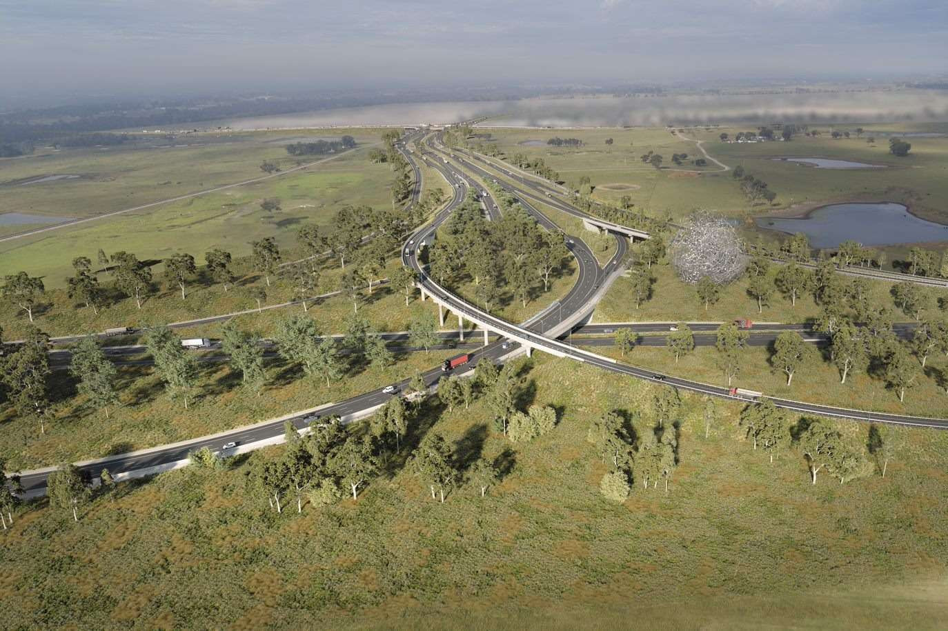
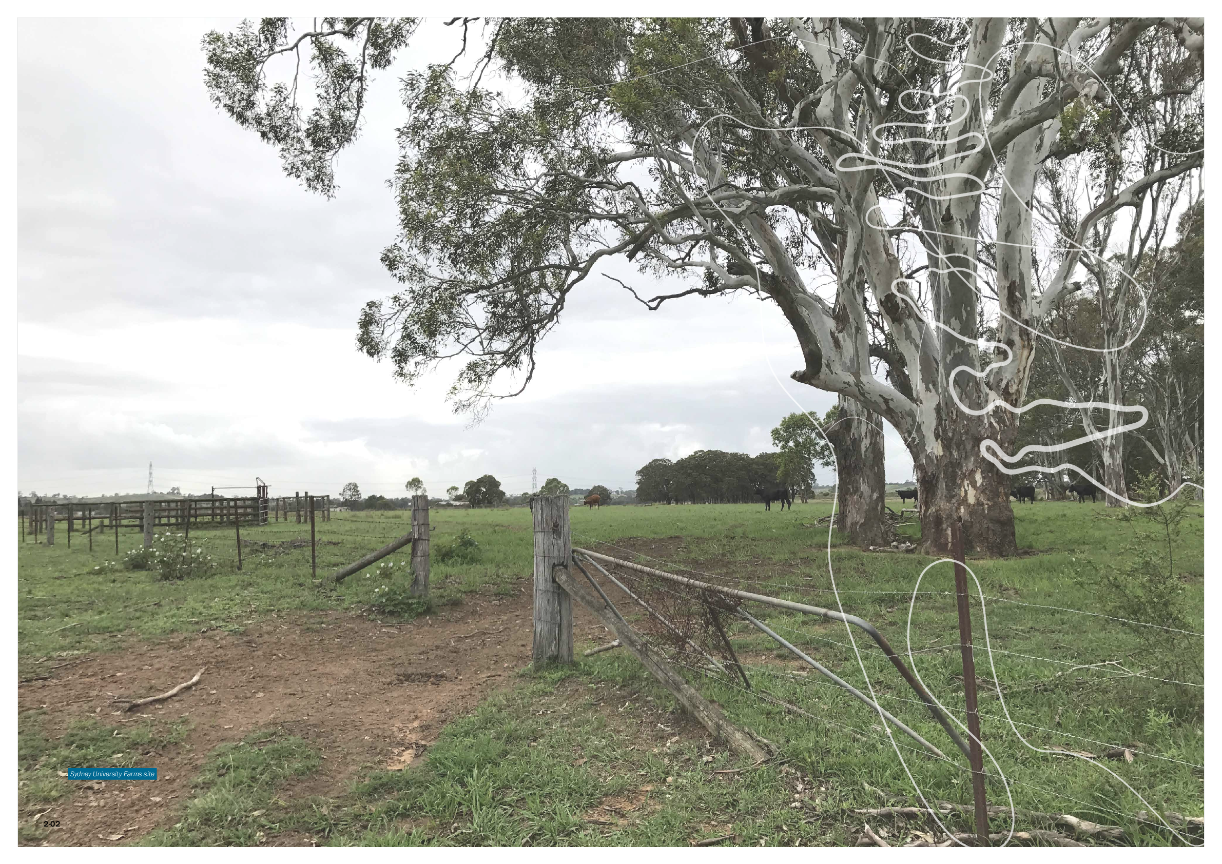
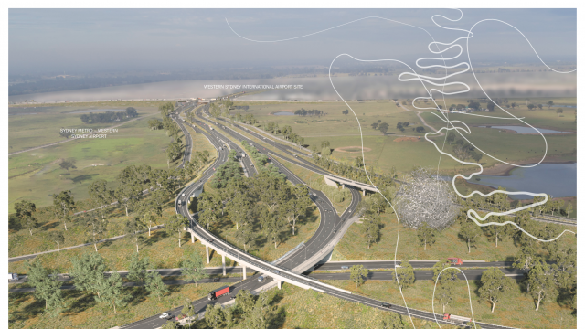
The PDLP covers the M12 Motorway corridor, an east-west 16 kilometre transport link between the M7 Motorway, Cecil Hills and The Northern Road, Luddenham.

The PDLP which accompanies the M12 Motorway, crosses the local government areas of Fairfield, Liverpool and Penrith, and will pass through the suburbs of Cecil Park, Cecil Hills, Mount Vernon, Kemps Creek, Badgerys Creek and Luddenham.

The design illustrated in the PDLP has been developed after extensive consultation with key stakeholders including relevant councils, Western Sydney Parklands Trust, Heritage NSW, the community, and affected landowners and businesses on the concept design, during refinement of the design and the Environmental Impact Statement and Amendment Report exhibitions to understand and address community concerns and questions.

Key stakeholders have been consulted through a series of briefings and workshops at various stages of the M12 project development, attended by design teams as well as TfNSW representatives. Further discussion and consultation has also occurred during the development of the PDLP.

At the time the release of the PDLP for public display, briefings have been undertaken or requested with:

  • Penrith City Council,
  • Liverpool City Council,
  • Fairfield City Council,
  • Western Sydney Parklands Trust,
  • Heritage NSW,
  • Western Sydney International Airport
  • Western Parkland City Authority
  • Registered Aboriginal Parties for the project and the local Aboriginal community, and
  • TfNSW Urban Design Review Panel including independent practitioners

The Design Review Panel (DRP) was engaged in accordance with the Minister’s Conditions of Approval to advise on the development of the PDLP. The DRP is comprised of the following practitioners:

Practitioner

Area of expertise

Ms Leanne Tobin

· Public art/cultural interpretation public art; and

· Aboriginal cultural heritage

Mr Craig Burton

· European cultural heritage

Ms Mary Anne McGirr

· Landscape architecture; and

· Active transport

Mr Adrian Pilton

· Landscape architecture; and

· Active transport

Exhibition of the PDLP for public comment will run for four weeks between 1 and 28 November 2021. Feedback must be submitted before midnight Sunday 28 November.

You can provide your feedback via the M12 Motorway PDLP portal and click on the ‘Have your say’ link on the top of the page or by emailing your submission to m12motorway@transport.nsw.gov.au. If you can’t access a computer, please call us on 1800 517 155 and ask to make a submission on the M12 Motorway PDLP. A team member will record your submission via the online feedback form on your behalf.  

Topics you can provide feedback on during the public exhibition period include:

  • Landscape design
  • Planting species selection
  • Public domain elements on the shared path (e.g. benches)
  • Materials and finishes (e.g. facades on bridges, interpretation nodes)
  • Lighting and wayfinding (e.g. footpaths, signages)

The design illustrated in the PDLP has been developed after extensive consultation with knowledge holders, key stakeholders including relevant councils, Western Sydney Parklands Trust, Heritage NSW, the community, and affected landowners and businesses on the concept design, during refinement of the design and the Environmental Impact Statement and Amendment Report exhibitions to understand and address community concerns and questions.

Various research undertaken including cultural heritage plans have fed into the PDLP design including Aboriginal cultural interpretation.

During public exhibition, further consultation will be undertaken with stakeholders and the community to help finalise the PDLP.

Transport for NSW engaged Balarinji, an Aboriginal design agency early on during the project to conduct a process to prepare conceptual design directions that would be underpinned by a locally endorsed Aboriginal narrative. These design directions were gathered through an inclusive consultation process with artists and knowledge holders who originate from or live and work in the Aboriginal community through which the project would run.

In addition to this process, three Aboriginal Focus Group meetings were held for the project.

The M12 project is located on the land of the Mulgoa, Cabrogal and Cannemegal of the Darug (Dharug, Daruk) language group. It would pass through the Deerubbin Local Aboriginal Land Council (LALC) area and the northern boundary of Gandangara LALC. The project study area was traditionally the cornerstone of the three cultural groups from the area; Darug, Dharawal and Gandangara, and was a place where these groups would come together for ceremony. The area has a 40,000-year history and the Darug Nation are custodians of the land, comprising 35 clans and five to six kin groups within each clan.

Working with the outcomes from the M12 Aboriginal Cultural Interpretation report in 2018, Balarinji, following Cultural Design Principles, developed a high-level translation of the site’s narrative and Aboriginal aspirations. They have guided the artwork development and thinking about embedding Aboriginal sensibility into the Project. The project vision of ‘Connection to Country’ seeks to embed key interpretive themes by consider Aboriginal integration in a new way.

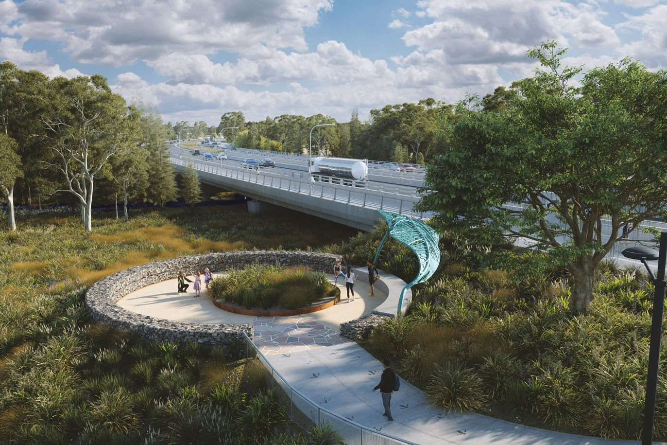
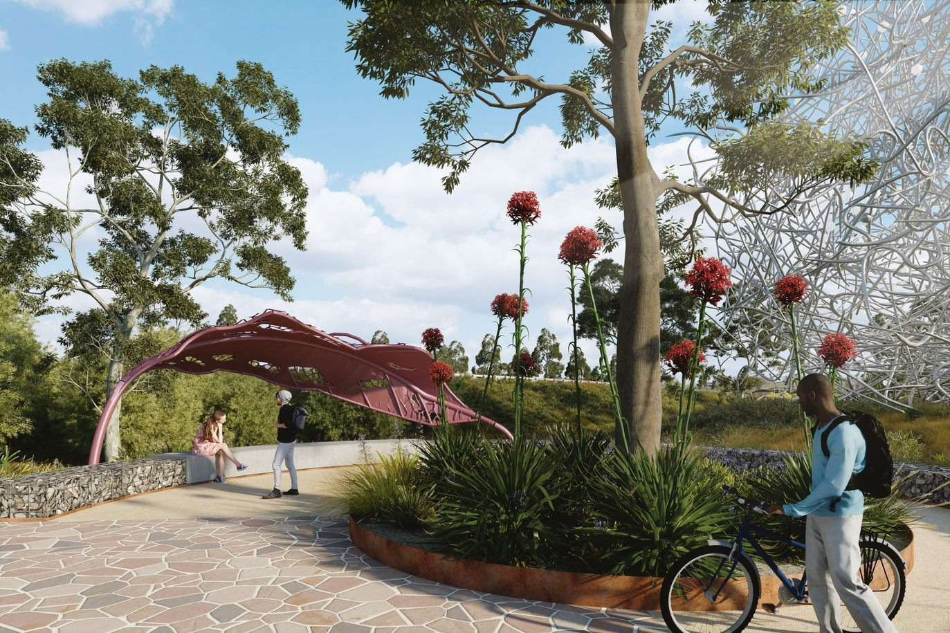
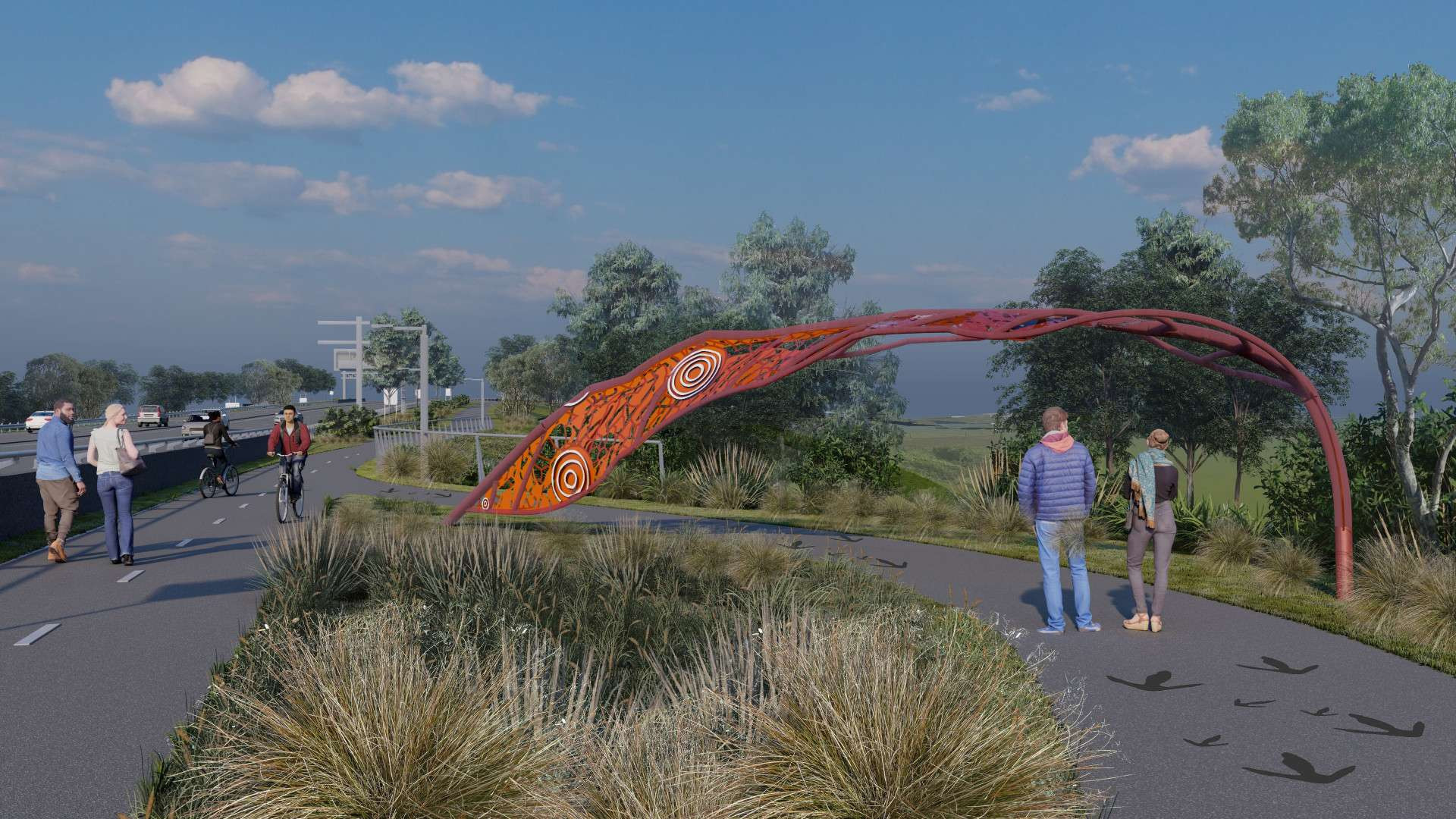
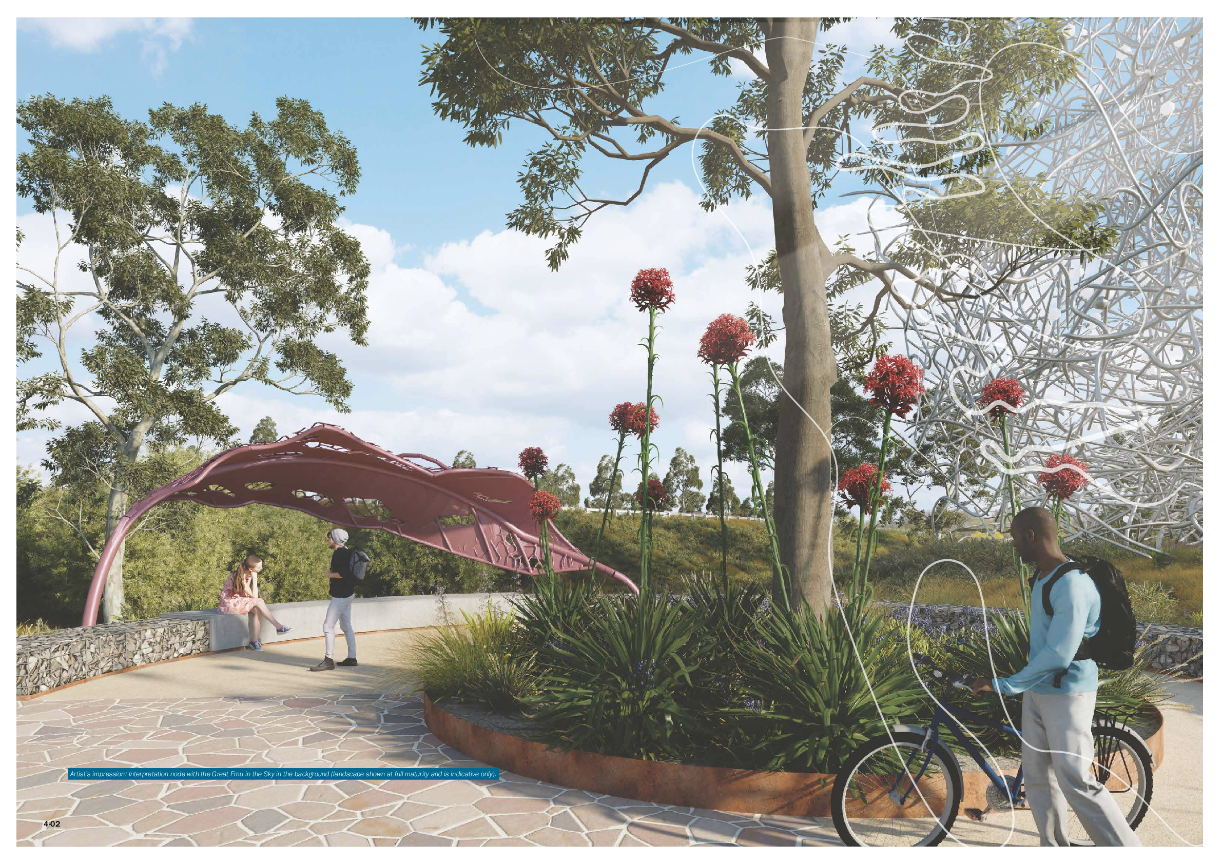
There are six key cultural interpretation elements that have been incorporated into the project including the emu. The emu is a Darug Community motif representing the sacred creation story of the Great Emu constellation. Aside from the landmark sculpture celebrating the Great Emu constellation, emu footprints used throughout the PDLP represent the experiences of people travelling along songlines and singing Country. Emu footprints are predominantly found at interpretation nodes, used as traffic calming devices and to provide cultural interest.

Transport for NSW engaged Balarinji, an Aboriginal design agency early on during the project to conduct a process to prepare conceptual design directions that would be underpinned by a locally endorsed Aboriginal narrative. These design directions were gathered through an inclusive consultation process with artists and knowledge holders who originate from or live and work in the Aboriginal community through which the project would run.

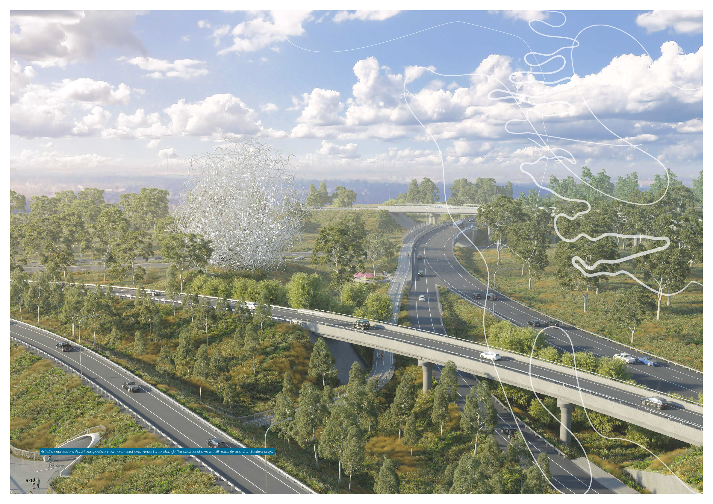
According to the Balarinji 'Aboriginal art strategy', there is a local Darug Dreaming Story which tells the story of Mariong (the Emu and Mother) and how she became the Milky Way. Mariong is sitting in the river, she stands up, shakes the water off her feathers and creates the stars, then becomes the Milky Way. Depicting this local Darug Dreaming story is the proposed 30m high Emu’s nest that acts a Welcome to Darug Country.

The artworks illustrated in the PDLP will be implemented during construction of the M12 Motorway including the landmark Emu in the Sky sculpture, and forms part of the construction contract to be awarded.

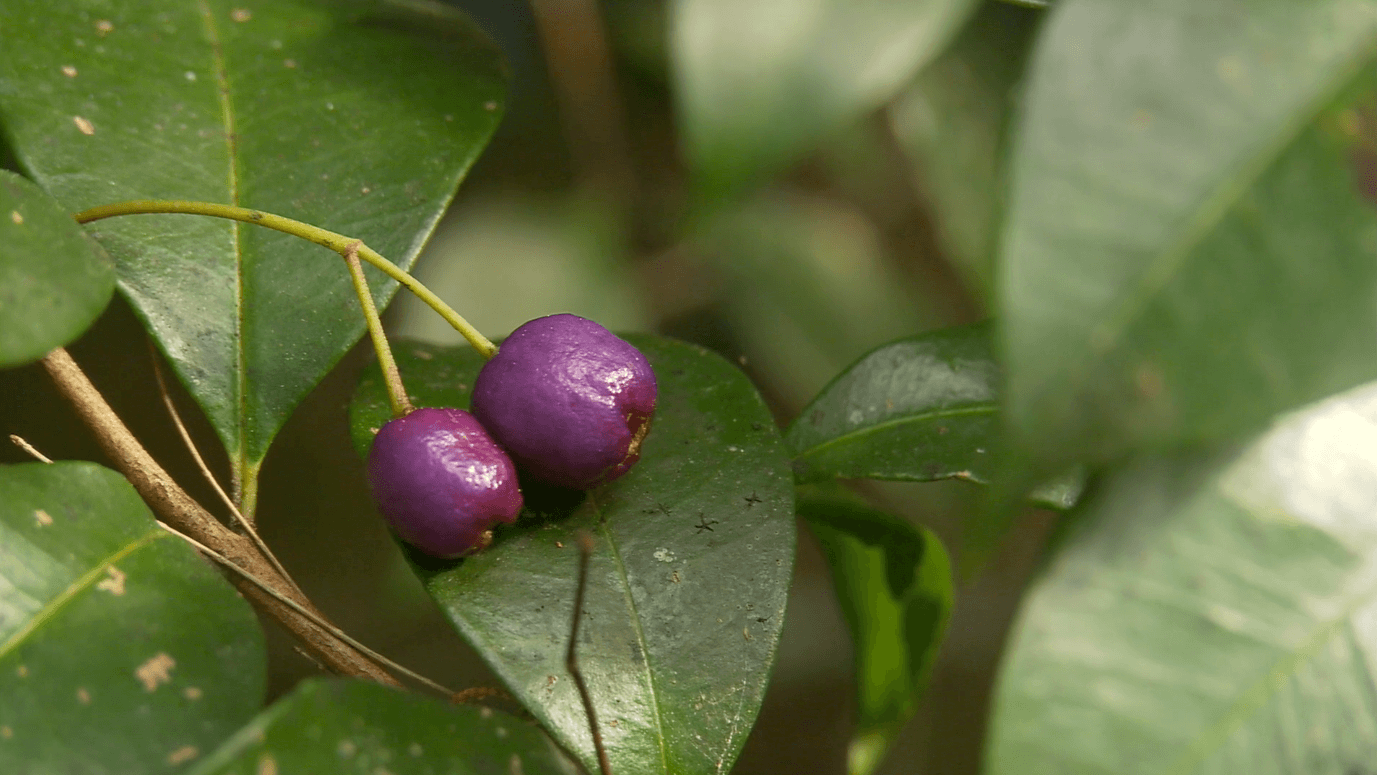
The M12 Motorway project provides a great opportunity for a well vegetated corridor, which is outlined in the PDLP. The project has been undertaking a seed collection and propagation program from mid-2020 to optimise replanting and vegetation growth from local indigenous species for when the motorway is open. Re-planting will have a focus on re-connecting fragmented ecological communities and being resilient in a changing landscape.

The M12 Motorway also adheres to planning conditions that address urban heat concerns with tree canopy requirements along the corridor, and to maximise planting in areas away from encroaching infrastructure needs.

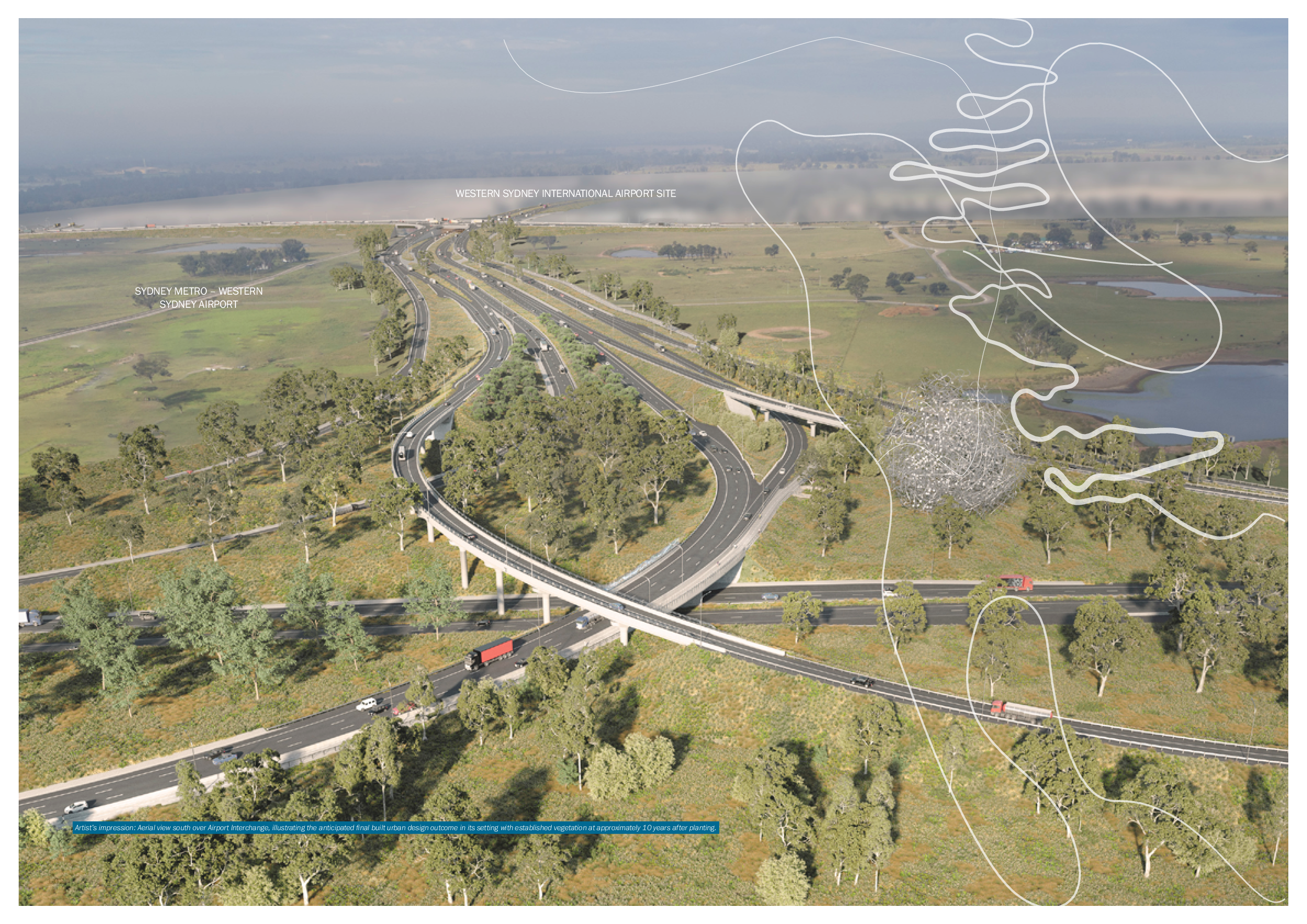
Due to requirements of other surrounding infrastructure, the M12 Motorway is unable create consistent levels of tree canopy and vegetation in all areas of the project. Some areas of the project in close proximity to the Western Sydney International Airport require a limit on the number of trees to mitigate wildlife hazards for aviation safety such as birds and bats. Transport for NSW has been working with the Western Sydney Planning Partnership to determine suitable plant species that can be planted within three kilometres of the Western Sydney International Airport.

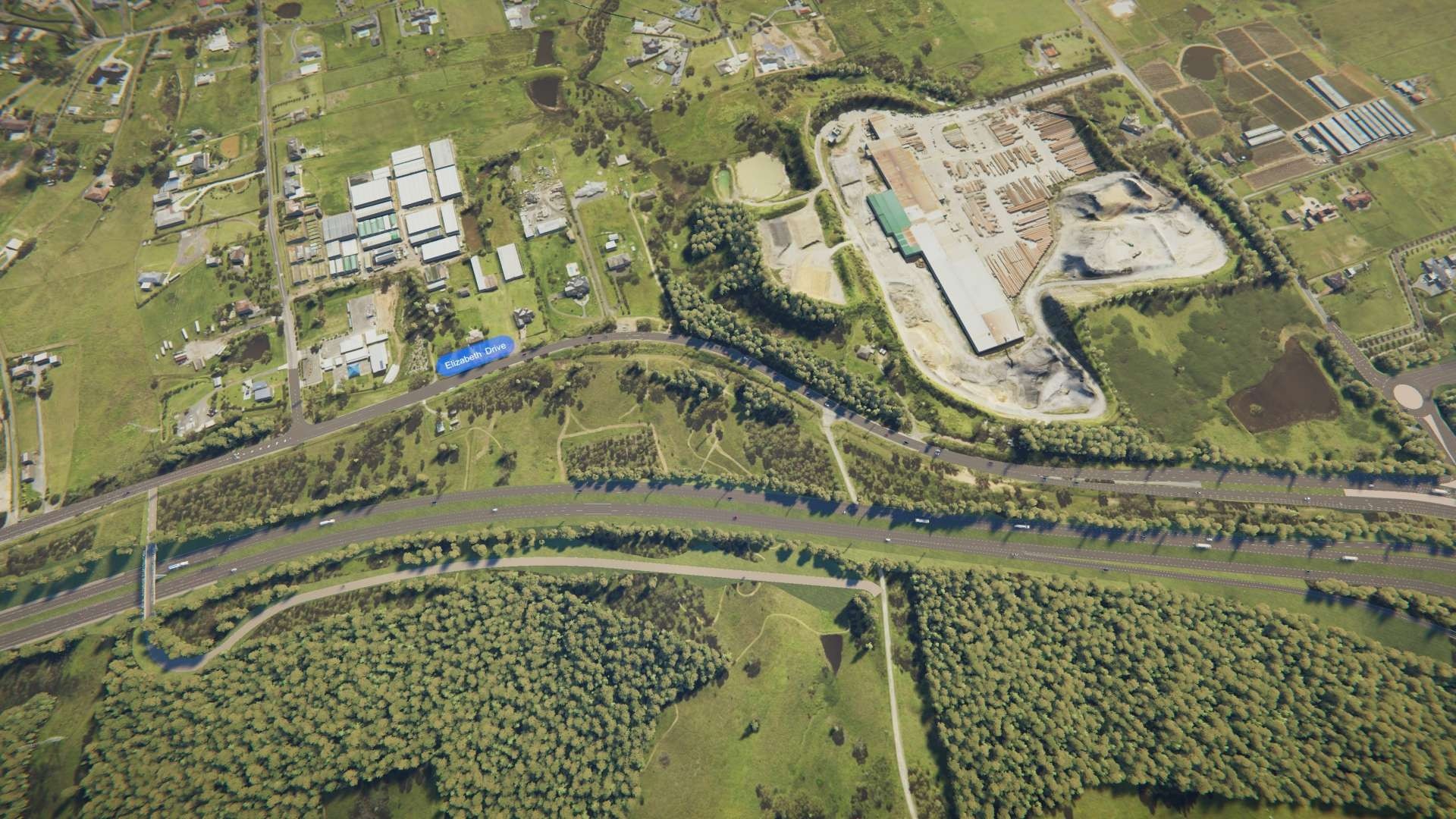
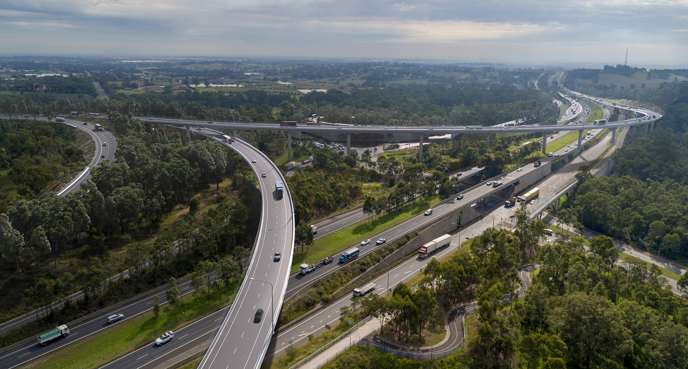
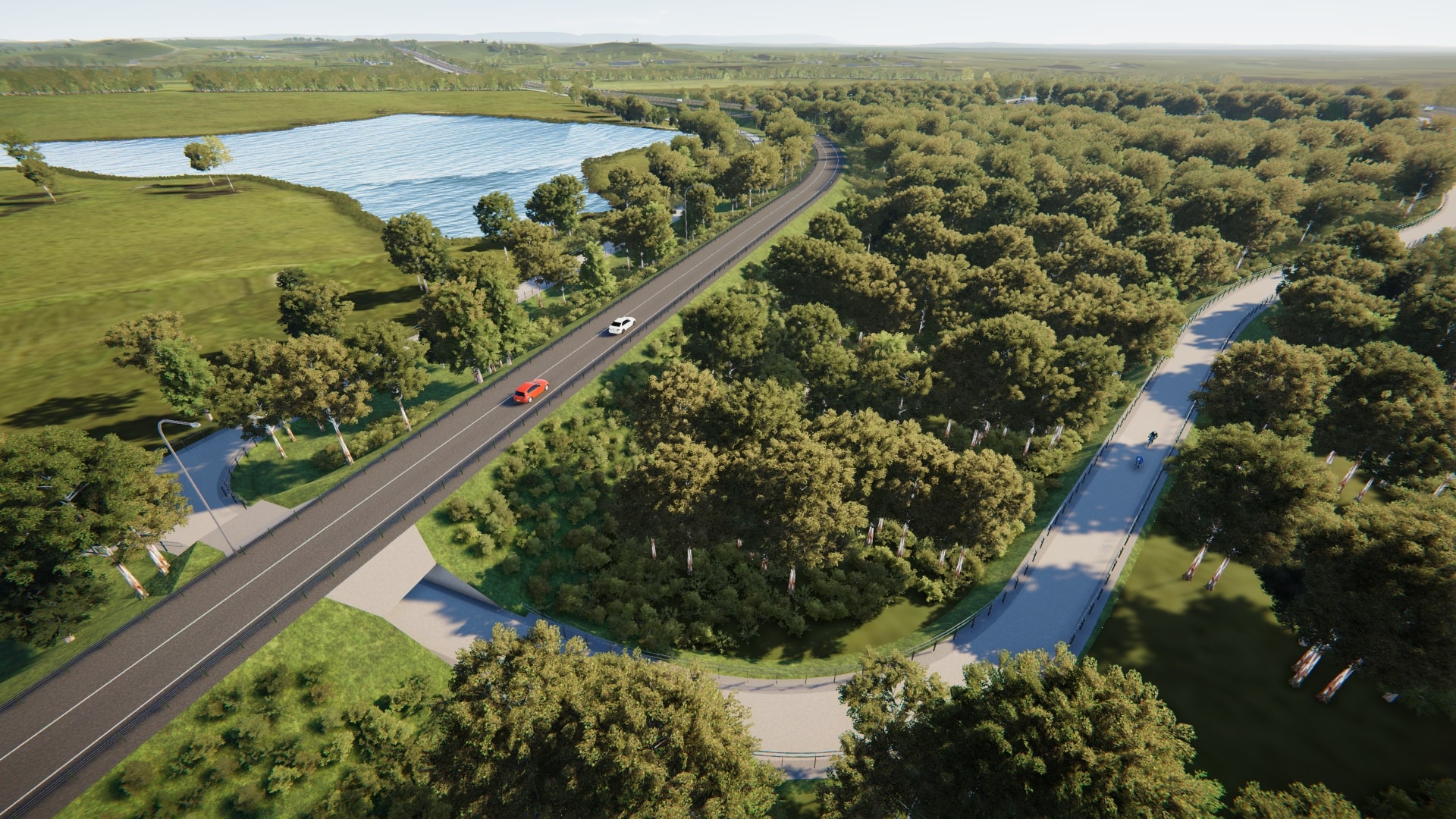
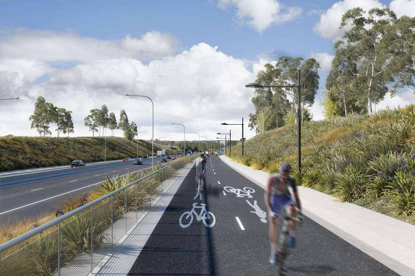
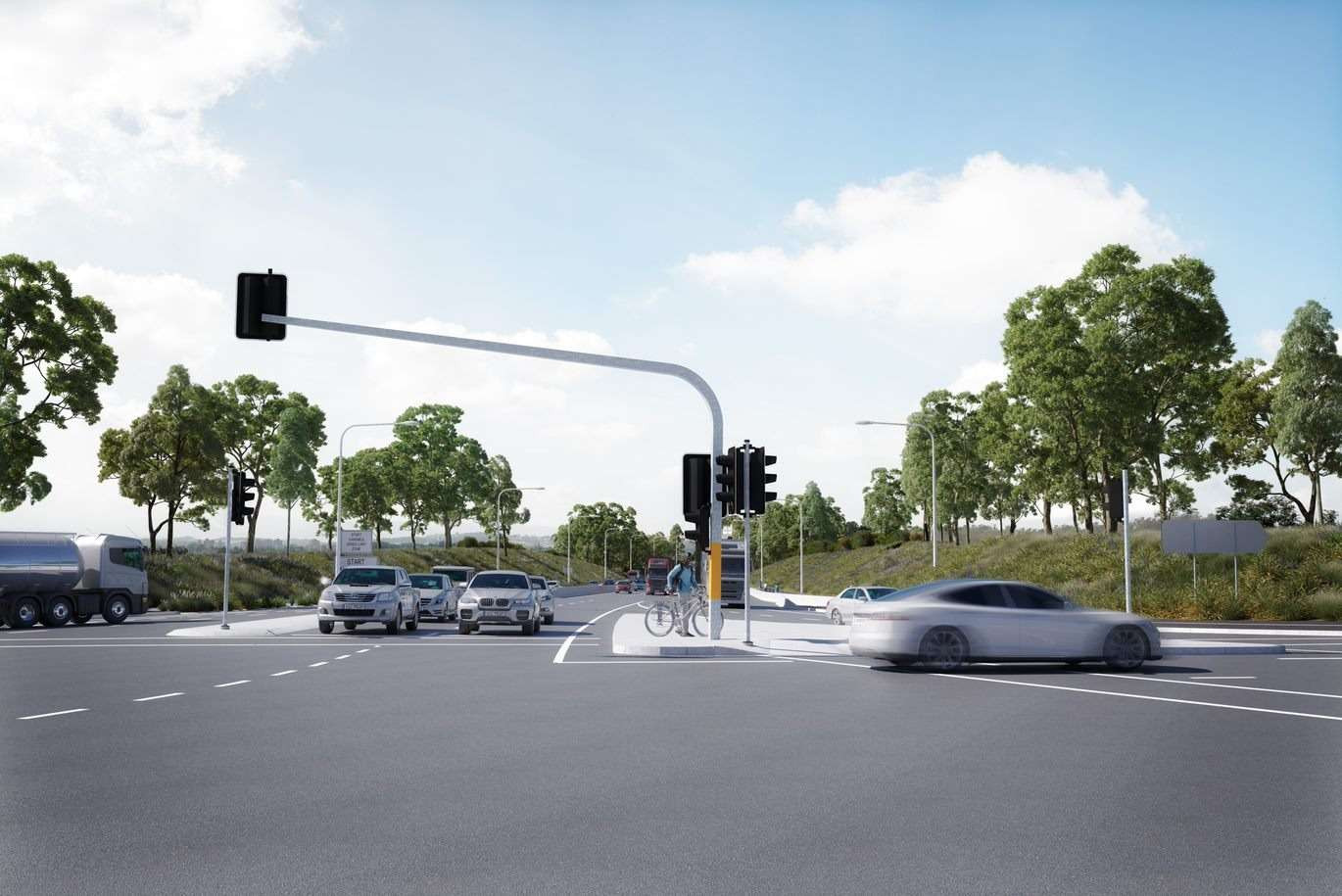
A shared walking and cycling path is one of several key features of the PDLP. This shared path will largely follow the M12 Motorway corridor with a section on the eastern end of the project going through the Western Sydney Parklands. This section of the shared user path will be delivered by the Western Sydney Parklands Trust.

There will be some impacts to the existing M7 Motorway shared user path during construction of the M7/M12 interchange. Transport for NSW will consult with relevant user groups prior to construction and take feedback on board to identify options and minimise impacts where possible.

Transport for NSW maintenance contractors will maintain the pedestrian cycling paths and public art in the M12 Corridor. Any paths on local roads will be handed to the relevant council to maintain.

Pedestrian and cyclist paths are shared along the M12 Motorway corridor.

The PDLP provides connectivity between existing and proposed routes for local communities. It provides details of the pedestrian and cyclist routes which will be provided as part of the M12 Motorway and how it will connect to other projects in the area such as the Western Sydney Parklands and the Elizabeth Drive Upgrade. It is envisaged that paths will connect to recreation corridors in adjacent planned precincts.

A shared pedestrian and cyclist link will be created between the M12 Motorway and the Western Sydney Parklands.

The M12 Motorway project acknowledges that as part of construction, there will be impacts to existing vegetation including the removal of trees and endangered ecological communities (including Cumberland Plain Woodland) across the project footprint. Transport for NSW commenced a tree survey along the length of the M12 Motorway alignment early on during the project lifecycle to understand the number of trees to be removed, habitat features and their potential for re-use. A total of about eighty-one hectares of native vegetation would be impacted by the project.

Transport for NSW will obtain biodiversity offsets for the project in accordance with NSW Biodiversity Offsets Policy for Major Projects (OEH, 2014) and will continue to consult with stakeholders during the detailed design and construction phase of the project. For trees not subject to biodiversity offsets (e.g. non-native or planted trees), TfNSW will aim to provide a net increase in the number of replacement trees at a ratio of 2:1. Re-planting density and canopy cover in some locations near the Western Sydney International Airport may be limited to mitigate wildlife hazards for aviation safety.

A seed collection and propagation program is also being undertaken, which has been designed to ensure the project can plan for landscaping and vegetation early on. The seed collection and propagation program aims to maximise the number of indigenous plant species from locally available seed for use in revegetation.

The design would source seeds from the region where possible to vegetate the project footprint and propagate local, native and suitable plant life. Native grassland and grassy woodland plants are resilient, attractive to pollinators, resilient to pests and are low fire risk. One of the key aims of the landscape design includes planting for a changing climate.

Transport for NSW maintenance contractors will maintain these.

Recommendations for materials and finishes have been included in the PDLP to ensure the look and feel of the design and landscape features are sustainable and remain resilient to the Western Sydney climate. These will be incorporated into future maintenance plans for contractors.

Once the exhibition period closes, we will collate and review all submissions received. These submissions will be categorised by topic and considered as we finalise the PDLP.

We will look into feedback received and determine what can be used to make any changes. Changes will be made to the PDLP where possible, and a Submissions Report will be made available on the Transport for NSW M12 Motorway website.

The PDLP will be finalised after the consultation and submissions period, and reviewed by Transport for NSW before being finalised and made available to the public.

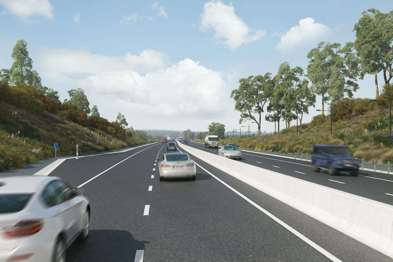
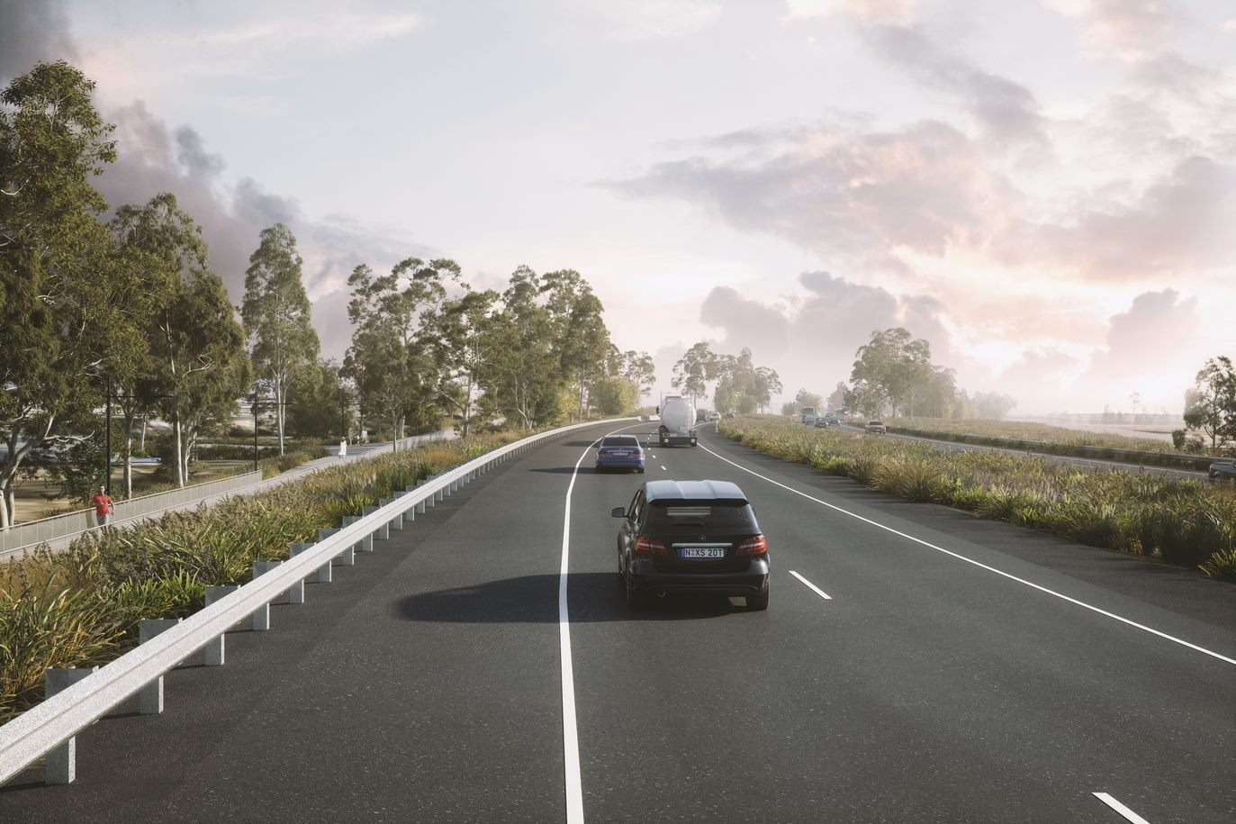
: The project will use tree planting and vegetation as visual screening along the M12 Motorway corridor. Current noise modelling indicates no noise walls are required for the project.

The design illustrated in the PDLP will be implemented during construction of the M12 Motorway.

As outlined in the PDLP, wildlife connectivity will be preserved with fauna passage opportunities located at all four main creek lines (Cosgroves, South, Kemps and Badgerys creeks). Bridges have been designed to ensure dry fauna passage can be provided for a range of ground dwelling fauna species, including kangaroos and wallabies. Rope bridges have also been provided at key locations to assist tree dwelling fauna (e.g. possums and gliders) cross the motorway corridor.

Secure fencing (including fauna fencing at key locations) and dedicated corridors will restrict access to important infrastructure, minimising the risk of wildlife venturing onto the road.

This chapter outlines the contextual analysis of the M12 Motorway corridor including the natural, built and community landscape such as land formation, existing land uses, soil, future land use, vegetation, Aboriginal and non-Aboriginal heritage.

Contextual analysis

View the chapter here

Contextual analysis

This chapter explores the overall project vision and the overarching urban design principles and objectives used to guide the outcomes. It also highlights how the vision of Connection to Country has been integrated across the motorway, and the ways in which cultural heritage interpretation studies have been used across the project.

Urban design concept

View the chapter here

Urban design concept

This chapter builds upon the urban design objectives, principles and strategies, to outline the overarching landscape concept. The concept responds to common characteristics found in the area such as the Cumberland Plain while adopting sound ecological principles and a strong connection with Country.

Landscape design

View the chapter here

Landscape design

This chapter included information on our overall design of bridges and walls across the project, their location, retaining wall types and finishes including cultural design embedded in all the overbridge safety screens.

Bridges and walls

View the chapter here

Landscape design

Artist impression of view south from Airport access road to Elizabeth Drive Interchange and entrance to the Western Sydney International Airport precinct
Artist impression of shared user path east along the M12 Motorway
Artist impression of view east along The Northern Road
Artist impression of motorist’s view east along the M12 Motorway
Artist impression of aerial view west over Kemps Creek and nearby interpretation node.
Artist impression of aerial view west over Airport Interchange
Artist impression of aerial view north east over Airport Interchange
Artist impression of motorist’s view north-west along the M12 Motorway (landscape shown is indicative only)
Artist impression of interpretation node with the Great Emu in the Sky sculpture in the background
Artist impression of interpretation node with large eucalypt leaf
Artist impression of aerial view south east across Range Road and the Western Sydney Parklands
Artist impression of interpretation node with small eucalypt leaf
Six Seasons (January to February)
Six Seasons (March to May)
Six Seasons (June to July)
Six Seasons (August)
Six Seasons (September to October)
Six Seasons (November to December)

Six seasons calendar

Executive summary
Introduction

Summary & Introduction

Executive summary

View the chapter here

Introduction

View the chapter here

Virtual Information Sessions

Select below to join us for our next live session.

Watch the webinar recording on 9 November at 1pm AEST (45min)

Community update β€” April 2021 thumbnail

Play the webinar recording

Watch the webinar recording on 9 November at 5pm AEST (45min)

Community update β€” April 20121 thumbnail

Play the webinar recording

*Download required: To join the session on a mobile device, download the Microsoft Teams app. To watch on a desktop computer, click ‘watch on the web instead’ or download the Microsoft Teams app.

You can use Chrome, Edge or Firefox for the video, however Safari is not supported.

Webinar recording on 9 November at 1pm AEST

Webinar recording on 9 November at 5pm AEST

Transport for NSW (RMS)

M12 Motorway

WEB PORTAL

  • Home
  • All documents
    Post approval documentationAssessments and EISCommunity informationWork activity archive
  • Map
  • Videos and images
  • Ask us a question
  • Share
  • Languages
© 2025 Transport for NSW (RMS) Powered by SEE
  
Log in
  • 语言
  • Linguaggio
  • μ–Έμ–΄
  • NgΓ΄n ngα»―

Transport for NSW pays respects to Elders past and present, and recognises and celebrates the diversity of Aboriginal peoples and their ongoing cultures and connections to the lands and waters of NSW.

Map of relocated Wylde Mountain Bike Trail (MBT)

Aerial view north west across M7-M12 Interchange

Aerial view south over Airport Interchange

Artist impression of Western Sydney International Airport

Shared path view north east at Airport Interchange

View south M12 on ramp M7 motorway

View east along The Northern Road

M12/M7 Interchange Cecil Hills

View on map

M12 Motorway - Ask us a question

Missing fields: Some required fields are missing. Please check your form.

If you have questions or would like more information, contact the project team:

1800 517 155

rms.nsw.gov.au/m12

m12motorway@transport.nsw.gov.au

Add your email list to the project database to ensure you receive the latest project updates.

To subscribe, please fill out the form below.


What do you think?

Missing fields: Some required fields are missing. Please check your form.
Question already submitted: Sorry, our records indicate that you have already submitted a question.

Thank you for submitting your feedback and subscription form. You are now in our stakeholder database and will be informed of the project updates if you have selected to subscribe.

Any feedback you have provided will be considered in our next steps.

All enquiries will be responded to within five working days.

Return to portal

Reset survey

M12 Motorway - Ask us a question

Missing fields: Some required fields are missing. Please check your form.

If you have questions or would like more information, contact the project team:

1800 517 155

rms.nsw.gov.au/m12

m12motorway@transport.nsw.gov.au

Add your email list to the project database to ensure you receive the latest updates and outcomes from the EIS exhibition.

To subscribe, send us your email address to -

m12motorway@transport.nsw.gov.au


What do you think?

Missing fields: Some required fields are missing. Please check your form.
Question already submitted: Sorry, our records indicate that you have already submitted a question.

Thank you for submitting your feedback and subscription form. You are now in our stakeholder database and will be informed of the project updates if you have selected to subscribe.

Any feedback you have provided will be considered in our next steps.

All enquiries will be responded to within five working days.

Return to portal

Reset survey

Share this

Thank you for using the M12 Motorway Portal. Transport for NSW invite you to share this information with your friends, family and colleagues via social media or email.

Share this via email

Share this on Facebook

Share this on Twitter

Share this on LinkedIn

M12 Motorway project status

Next steps

Roads and Maritime will actively look at ways to further reduce the impact of the M12 Motorway on the community. The corridor route is generally 300 metres wide, however the final width of the motorway corridor (i.e the final road reserve for the motorway) would be around 150 metres typically, wider around intersections/interchanges. The reduced corridor will be included in the display of the EIS.

M12 Project timeline placeholder

About the M12 Motorway

On behalf of the Australian and NSW governments, Roads and Maritime Services is planning the M12 Motorway as part of the $3.6 billion Western Sydney Infrastructure Plan. The M12 Motorway will provide direct access to Western Sydney International Airport at Badgerys Creek and connect to Sydney’s motorway network.

As of November 2017, a preliminary design has been developed with some changes to the preferred corridor route announced in 2016. We are now seeking community feedback to inform the next stage of design.

The M12 Motorway would:

  • provide direct access from the M7 Motorway to Western Sydney International Airport at Badgerys Creek, and from the M4 Motorway via the upgraded The Northern Road
  • improve access to the Western Sydney International Airport Priority Growth Area and the South West Priority Land Release Area
  • increase road capacity for future growth and development
  • improve traffic safety for road users
  • incorporate pedestrian and cyclist infrastructure
  • improve freight movement to key commercial centres.

What is an EIS?

An Environmental Impact Statement (EIS) describes the key features of a project and assesses the potential environmental and social impacts during construction and operation. The EIS for the M12 Motorway outlined the measures that will be implemented to manage and minimise potential impacts from the project.

The NSW Department of Planning, Industry and Environment (DPIE) placed the EIS for the M12 Motorway on exhibition for 28 days from Wednesday 16 October 2019 until 18 November 2019. This provided the community, government agencies and stakeholders with an understanding of what the project proposes and gave them an opportunity to make comment on the project.

Transport for NSW considered all feedback received during the EIS display period and made amendments to the project as a result. These amendments are described and assessed in an amendment report, which is now on exhibition for 14 days for public comment.

Read the Amendment Report

The EIS Submissions Report documenting the submissions and responses to the issues raised during EIS exhibition has now been submitted to the DPIE.

Read the EIS Submissions Report

Following exhibition of the amendment report, TfNSW will prepare a supplementary EIS submissions report if required. DPIE will then prepare an assessment report for the Minister of Planning and Public Spaces and the Australian Environment Minister who will determine whether or not the project will be granted approval and any conditions of approval.

What’s changed?

Why has Transport for NSW prepared an Amendment Report (AR)?

Transport for NSW (Transport) submitted a request to the Department of Planning, Industry and Environment (DPIE) to amend the project under clause 192 of the Environmental Planning and Assessment Regulation 2000 (NSW) (EP&A Regulation) to include changes to design and construction since the Environmental Impact Statement (EIS) exhibition.

These project changes provide functional improvements to the design and improved integration with surrounding major transport infrastructure projects and potential future development. They also respond to issues raised in community and stakeholder submissions, and in some instances, further reduce the potential impacts of the project as described in the EIS.

DPIE gave Transport approval to amend the project in May 2020 and requested that Transport prepare an Amendment Report to outline the proposed design and construction changes to the project and assesses the associated environmental impact. Where required, the report has included additional or revised environmental management measures to manage or minimise environmental impacts.

The Amendment Report is on public exhibition for two weeks to give the community, government agencies and stakeholders an opportunity to comment on the amended project.

Using this portal

The M12 Motorway EIS report has been made available in this web portal through a brief summary shown in our interactive map. The entire EIS report and individual chapters are available for more in-depth discovery on all the findings here.


About

About the EIS

Community update


Project details

Map

Videos and images

Make a submission

To make a submission on the Amendment Report, use the online form. All submissions received will be placed on the DPIE website.

For a video tutorial on how to make a submission on the DPIE website click here.

To watch a video tutorial about how you can subscribe to receive timely, project-related alerts click here.

If you want the Department to delete your personal information before publication, please make this clear at the top of your letter.

EIS Events

Information sessions

This is your chance to speak to the project team about the EIS

Thursday, 24 October
Kemps Creek Public School, 100 Cross Street Kemps Creek
5:00 p.m. to 8:00 p.m.
Saturday, 26 October
Holy Family Primary School, Lot 32 Willowdene Avenue Luddenham
10:00 a.m. to 1:00 p.m.
Saturday, 2 November
Kemp Creek Sports and Bowling Club 1490 Elizabeth Drive, Kemps Creek
10:00 a.m. to 1:00 p.m.
Thursday, 7 November
Holy Family Primary School, Lot 32 Willowdene Avenue Luddenham
5:00 p.m. to 8:00 p.m.

Display locations for the EIS

Information is also available from the following locations:

Transport for NSW office

20–44 Ennis Road, Milsons Point

Department of Planning, Industry and Environment

320 Pitt Street, Sydney

Nature Conservation Council

4/338 Pitt Street, Sydney

Western Sydney Airport Visitor Centre

Eaton Road, Luddenham

Service Centres (electronic copies available only)

cnr Coffs and Duke Streets, Coffs Harbour

Libraries

St Claire Library

Shop 12, St Claire Shopping Centre, Bennett Road and Endeavour Avenue

Wetherill Park Library

561–583 Polding St, Wetherill Park

Carnes Hill Library

600 Kurrajong Rd, Carnes Hill

Council offices

Fairfield City Council

86 Avoca Road, Wakeley

Liverpool City Council

33 Moore Street, Liverpool

Penrith City Council

Civic centre 601 High Street, Penrith

Camden Council

70 Central Ave, Oran Park

Filter the EIS

Select the topics you are interested in reading about

Biodiversity
Transport and traffic
Urban design and visual impacts
Socio-economic, land use and property
Aboriginal heritage
Non-aboriginal heritage
Noise and vibration
Flooding
Surface water quality and hydrology
Groundwater quality and hydrology
Soils and contamination
Air quality
Health and safety
Sustainability
Waste
Climate change risk and greenhouse gas
Environmental management measures
Environmental risk analysis

Related chapters

Select from topics of interest above

Section 7.1

Biodiversity

Download

Key topics

Biodiversity

Section 7.2

Traffic and Transport

Download

Key topics

Traffic
Transport

Section 7.3

Urban design and visual impacts

Download

Key topics

Urban design
Visual impacts

Section 7.4

Socio-economic, land use and property

Download

Key topics

Property impacts
Land use

Section 7.5

Aboriginal heritage

Download

Key topics

Aboriginal heritage

Section 7.6

Non-aboriginal heritage

Download

Key topics

Heritage

Section 7.7

Noise and vibration

Download

Key topics

Noise
Vibration

Section 7.8

Flooding

Download

Key topics

Flooding

Section 7.9

Surface water quality and hydrology

Download

Key topics

Water quality

Section 7.10

Groundwater quality and hydrology

Download

Key topics

Water quality

Section 8.1

Soils and contamination

Download

Key topics

Soil

Section 8.2

Air quality

Download

Key topics

Air quality

Section 8.3

Health and safety

Download

Key topics

Health and safety

Section 8.4

Sustainability

Download

Key topics

Sustainability

Section 8.5

Waste

Download

Key topics

Waste

Section 8.6

Climate change risk and greenhouse gas

Download

Key topics

Climate change
Greenhouse gas

Chapter 9

Environmental management measures

Download

Key topics

Environment

Chapter 10

Environmental risk analysis

Download

Key topics

Environment

Make a submission

To make a submission on the Amendment Report, use the online form. All submissions received will be placed on the DPIE website.

For a video tutorial on how to make a submission on the DPIE website click here.

To watch a video tutorial about how you can subscribe to receive timely, project-related alerts click here.

If you want the Department to delete your personal information before publication, please make this clear at the top of your letter.

Virtual Information Session

Watch the replay of the event from 28 October 1pm

M12 Motorway - Overarching Communication Strategy feedback

TfNSW welcomes feedback on the M12 Overarching Communication Strategy at any stage of the project. Feedback would be considered as part of the ongoing performance monitoring and evaluation process.

If you have questions or would like more information, contact the project team:

1800 517 155

rms.nsw.gov.au/m12

m12motorway@transport.nsw.gov.au


Subscribe to updates
What do you think?

Missing information

One or more required fields are missing data, or fields are invalid. Please check your form and submit again.

Error during submission

Something went wrong, please try again.
Please be patient, form submission can take up to 10-30 seconds.

Submission received

Thank you for your feedback on the M12 Overarching Communication Strategy. TfNSW will consider this feedback as part of the six monthly performance and effectiveness evaluation report and the minimum annual review of the strategy.
 

M12 Motorway - Place, Design and Landscape Plan feedback

TfNSW welcomes feedback on the Place, Design and Landscape Plan. All feedback will be considered as part of the design.

If you have questions or would like more information, contact the project team:

1800 517 155

rms.nsw.gov.au/m12

m12motorway@transport.nsw.gov.au


Subscribe to updates
What do you think?

Missing information

One or more required fields are missing data, or fields are invalid. Please check your form and submit again.

Error during submission

Something went wrong, please try again.
Please be patient, form submission can take up to 10-30 seconds.

Submission received

Thank you for your feedback on the M12 Overarching Communication Strategy. TfNSW will consider this feedback as part of the six monthly performance and effectiveness evaluation report and the minimum annual review of the strategy.
 

Western Sydney International Airport interchange

Western Sydney International Airport connection at Elizabeth Drive

M12 over Elizabeth Drive near Mamre Road

M7 interchange

Elizabeth Drive connection

The Northern Road Intersection