Insecure browser/WebGL disabled: There are security and user experience issues with your current browser. A secure modern browser with WebGL enabled is required to display interactive maps and other features.
NSW Government

M6 Stage 1 WEB PORTAL

  • About
    About M6 Stage 1 New recreational facilities
  • Interactive map
  • Documents and media
    Latest updates Project approvals Videos and images
  • Subscribe to updates
  • Contact the team

Project approvals

Select a document below to download. Please check back here as the project progresses for updates.

Construction

Select
Plans and Strategies Reports Appointments

Pre-Construction

Select
Plans and Strategies Reports Appointments Approvals EIS chapters

Construction


Pre-Construction


Approvals


Recreational Facilities Replacement Plan – May 2020

Learn more about the replacement of your recreational facilities

Planning approval
Planning approval

Learn more about the now-approved changes to the project design

Card image cap
Submissions report

Read our response to your feedback on our Review of Environmental Factors (REF)

Card image cap
Review of Environmental Factors - November 2019

View our concept design and Review of Environmental Factors

Card image cap
Submissions Report — April 2019

The Submissions Report responds to submissions made by the community, councils and government agencies

Card image cap
Preferred Infrastructure Report (PIR) — April 2019

The PIR assesses alternative design options that were an outcome of the EIS exhibition. We are making two changes to the design based on your feedback:

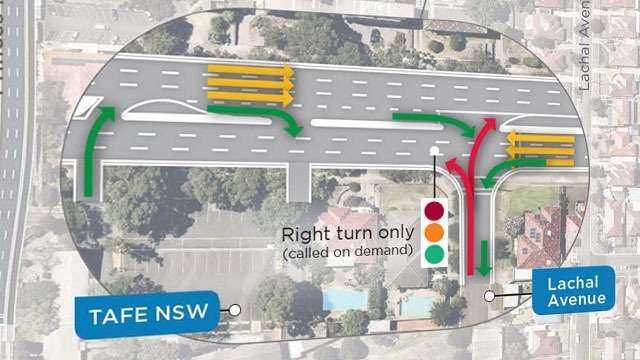
1. Traffic changes will include improved access arrangements on President Avenue

2. The shared cyclist and pedestrian pathway will be extended further south to O’Connell Street, Kogarah.

These proposed changes are subject to planning approval

Planning approval
Project overview - November 2018

Information released to support the public exhibition of the Environmental Impact Statement

Learn more about our approval
Learn more about our Addendum REF

August 2020

EIS chapters

Filter EIS by topic

General and overview

Back to top

Executive summary

This portal provides information about the design and features of the M6 Stage 1. It presents key information presented in the Environmental Impact Statement (EIS) for the project, in an interactive, visual and informative way to support the Department of Planning and Environment’s public exhibition process. The EIS describes the potential environmental and social impacts that may occur during construction and operation of the project, and the measures to mitigate against these impacts.

The design of the M6 Stage 1 is subject to further refinement as it progresses through the planning approval process and community engagement phase.

Show more
Explore this chapter
Chapter 1: Introduction

The M6 Stage 1 features four kilometre twin tunnels from the M8 at Arncliffe to President Avenue at Kogarah. The scope of work includes:

● Entry and exit ramps and a tunnel portal connecting to a new surface intersection at President Avenue

● Provision of underground tunnel stubs for a future connection south to extend the M6 Stage 1

● Upgrade of the President Avenue/Princes Highway intersection

● New shared cyclist and pedestrian pathways including a pedestrian bridge over President Avenue.

Show more
Explore this chapter
Chapter 2: Assessment process

Roads and Maritime is seeking approval for the M6 Stage 1 as State significant infrastructure which requires assessment and approval under 5.2 of the Environmental Planning and Assessment Act 1979. The Environmental Impact Statement is on public display from 7 November to 14 December for the community and stakeholders to comment on the project. A final submissions report with responses to issues raised is submitted to the Department of Planning and Environment. The report will be submitted to the NSW Department of Planning and Environment, and helps to inform the Minister for Planning’s decision on the project.

Show more
Explore this chapter
Chapter 3: Consultation

Consultation began in October 2017 with community engagement activities such as doorknocking, the distribution of community updates, pop up events at local shopping centres and briefings with key stakeholders, schools and government agencies. This feedback informed the environmental assessments on increased traffic and congestion, loss of property and green space, local air and water quality as well as noise and emissions from ventilation outlets. From June to August 2018 extensive consultation was carried out to support the release of more detailed project information and design and seek further community feedback.

Show more
Explore this chapter
Chapter 4: Strategic context and project need

Population and traffic growth in Greater Sydney places increased pressure on our transport network. The M6 Stage 1 will ease congestion on surface roads and allow users to by pass up to 23 sets of traffic lights on the Princes Highway between St Peters and Kogarah. Traffic will reduce on General Holmes Drive by around 10,000 vehicles per day, returning local streets to the local community, providing opportunities to improve the amenity around The Grand Parade and Princes Highway. Stage 1 will improve connectivity to the wider Sydney transport network.

Show more
Explore this chapter
Chapter 5: Project alternatives and options

Assessments reveal the M6 Stage 1 will deliver improved community benefits, and a direct connection to the Sydney motorway network compared with other options. A range of alternative alignments, connections and intersection options were considered. The preferred design provides a combination of benefits compared with other options including better constructability, improved access and minimal impacts on property.

Show more
Explore this chapter
Chapter 6: Project description

Key features of the M6 Stage 1 include:

● Four kilometre twin tunnels linking the M8 at Arncliffe to President Avenue at Kogarah

● A new intersection at President Avenue with entry and exit ramps connecting the tunnel to the surface road

● The provision of underground tunnel stubs for future connection south to extend the M6 Stage 1

● An upgrade of the President Avenue/Princes Highway intersection

● A new shared cyclist and pedestrian pathways and a pedestrian bridge across President Avenue

● Motorway operation complexes at Arncliffe and Rockdale

● Reinstatement of Bicentennial Park and recreational facilities.

Show more
Explore this chapter
Chapter 7: Construction

Construction will take around four years to complete.

The main construction sites will be located at Arncliffe (Marsh Street), President Avenue (within an area of Bicentennial Park) and Rockdale (West Botany Street).

Investigations and site establishment will occur before tunnelling and surface earthworks begin.

Permanent operational infrastructure will be built as well as drainage and water management facilities. Road pavement and finishing works will occur at the end of the project.

Standard construction hours apply from 7am to 6pm Monday to Friday and 8am to 1pm Saturday. However, some construction work such as tunnelling will continue 24 hours a day.

Construction noise will be minimised with acoustic sheds where spoil will be managed and noise barriers will be installed at site locations.

Show more
Explore this chapter

EIS chapters – Project assessment categories

Back to top

Chapter 8: Traffic and transport

Key features of the M6 Stage 1 include:

● Four kilometre twin tunnels linking the M8 at Arncliffe to President Avenue at Kogarah

● A new intersection at President Avenue with entry and exit ramps connecting the tunnel to the surface road

● The provision of underground tunnel stubs for future connection south to extend the M6 Stage 1

● An upgrade of the President Avenue/Princes Highway intersection

● A new shared cyclist and pedestrian pathways and a pedestrian bridge across President Avenue

● Motorway operation complexes at Arncliffe and Rockdale

● Reinstatement of Bicentennial Park and recreational facilities.

Show more
Explore this chapter
Chapter 9: Air quality

During construction

A Construction Air Quality Management Plan will be implemented to minimise potential air quality impacts. This includes measures to minimise dust from stockpiles, reduce vehicle emissions and modify dust generating activities during windy weather conditions.

During operation

Analysis shows the tunnel ventilation system meets in-tunnel air quality criteria for all expected traffic scenarios.

The M6 Stage 1 ventilation outlets will require an Environmental Protection Licence issued by the NSW Environmental Protection Authority to assess ambient and outlet air quality against strict controls and criteria.

Under expected traffic conditions for the project, the predicted contribution of tunnel ventilation outlets to local air quality is negligible. Any predicted changes in concentrations were driven by changes in the traffic volumes on the modelled surface road network, not by the tunnel ventilation outlets

Show more
Explore this chapter
Chapter 10: Health, safety and hazards

During construction

As the safety of workers and the public is a priority for Roads and Maritime, a Construction Environmental Management Plan will be implemented and Safe Work Method Statements employed to minimise the potential for safety incidents. The effective management of dust, odour and other emissions during construction as part of this Plan will avoid human health impacts

During operation

Assessments reveal there are no person is exposed to unacceptable levels of air pollution. No adverse health effects are expected from exposures to carbon monoxide in the local area surrounding the project. The risk of health impacts on the community due to air quality is negligible.

Show more
Explore this chapter
Chapter 11: Noise and vibration

During construction

Residents close to each construction site will be impacted by noise, but construction work, where possible, will be limited to standard construction hours. However, during tunnelling work will continue 24 hours a day.

Residents at the Princes Highway/President Avenue intersection may experience noise impacts during night work, which is required to minimise traffic impacts and for the safety of workers and the public.

Traffic noise due to earthmoving and construction equipment, spoil haulage, collection and delivery of materials and traffic movements by construction workers is expected to be minimal.

A Construction Noise and Vibration Management Plan will be implemented and two acoustic sheds will be built to facilitate spoil haulage removal. Noise barriers will be installed at construction sites to reduce noise impacts. Roads and Maritime will work closely with local residents and stakeholders to minimise the impact of noise and vibration.

During operation

Some residents will be impacted by increased noise levels requiring additional noise mitigation measures. Impacted residents will be contacted directly to implement these measures. Within 12 months of the tunnel opening, actual operational noise will be compared to predicted noise to determine the need for additional noise mitigation or management measures.

Show more
Explore this chapter
Chapter 12: Biodiversity

During construction

Assessments reveal the presence of grey headed flying fox in Bicentennial Park however no green and golden bell frogs or southern myotis microbats were found during surveys.

The waterway in Bicentennial Park will be diverted leading to a temporary loss of aquatic and riparian habitat and local fish will be obstructed.

Mature trees and other vegetation will be lost, but the wetlands and vegetated area will be fully reinstated after construction.

A Flora and Fauna Management Plan will be implemented during construction

During operation

The M8 motorway Green and Golden Bell Frog Management Plan and Flora and Fauna Management Plan will continue to operate.

Show more
Explore this chapter
Chapter 13: Landscape and visual

During construction

Impacts on Bicentennial Park include the relocation of the playground, skate park and sporting fields which will be reinstated once the project is complete. Some mature trees around President Avenue will be removed. The ventilation facility at West Botany Street will have low impacts on the views from some residential areas, parks and streets when compared with surrounding buildings.

During operation

Planting and vegetation will be similar to the surrounding wetlands and recreational open spaces. Trees will be planted along President Avenue and the wetland pond will be restored. The shared pedestrian and cycle pathway will complement the surrounding landscape while the urban design includes screens, lighting and fencing to complete a well-ordered and uncluttered profile.

Show more
Explore this chapter
Chapter 14: Property and land use

The M6 Stage 1 involves the acquisition of 12 privately owned properties, the partial acquisition of three privately owned properties and extinguishment of six leases for permanent infrastructure. Some below surface land will also need to be acquired. Residual project land in Bicentennial Park will be required during construction and will be re-instated for use as parkland which includes landscaping work.

A Personal Acquisition Manager is appointed and an Acquisition Assistance Line will operate following completion of the final acquisition to provide dispute resolution and relevant services.

A Residual Land Management Plan will be prepared in consultation with local councils and key stakeholders.

Show more
Explore this chapter
Chapter 15: Social and economic impacts

The social and economic impacts include assessments of demographics, connectivity, community liveability, employment, property, traffic and transport, parking, and accessibility.

Around 3,250 jobs will be created onsite during the construction period and another 2,050 jobs will be generated off-site in each year of construction.

Over the duration of construction the project will generate around $4.3 billion of local activity.

A Community and Social Management Plan will be prepared and a Business Management Plan will address the impacts to local businesses. A Construction Ancillary Facilities Management Plan will outline how noise, dust, traffic, visual and overshadowing impacts will be reduced.

Active transport pathways will benefit pedestrians, cyclists and dog walkers in the area and local business will benefit from reduced congestion on local roads.

Show more
Explore this chapter
Chapter 16: Soils and contamination

During construction

During excavation and construction of the cut and cover tunnel, land in Bicentennial Park that has been contaminated may be disturbed, potentially releasing landfill gases into the air causing odours. There is also a risk of soil erosion around waterways and slopes. New drainage infrastructure may be required around Cooks River, Muddy Creek and Scarborough Ponds.

A Construction, Soil and Water Management Plan and a Hazardous Building Materials Management Plan will be implemented. Construction water treatment plants will be in operation and an Acid Sulfate Management Plan will also be prepared.

During operation

Erosion may occur during the landscaping and re-establishment of vegetation at Bicentennial Park. At the tunnel portal, water may be discharged leading to impacts on water quality in the environment.

Show more
Explore this chapter
Chapter 17: Groundwater and geology

During construction

Assessments reveal that potential groundwater impacts may include reduced groundwater levels and changes to groundwater quality.

The planned groundwater monitoring program may trigger remedial action based on the results of water monitoring.

A detailed Groundwater Model will be developed to predict inflow rates and volumes within the tunnels and at ground level. A Groundwater Monitoring Program will also be implemented. A

During operation

A water treatment plant will be constructed to manage and treat groundwater from the tunnel before it is discharged.

Show more
Explore this chapter
Chapter 18: Surface water and flooding

Surface water and flooding have been assessed for impacts to surface water hydrologic and geomorphic processes, erosion of soils and banks, and changes to the flow and volume of water quality in waterways.

A Flood Management Strategy will be implemented and surface and groundwater monitoring will take place in the Rockdale wetlands prior to construction.

Ground water will be treated at the operational water treatment plant or disposed offsite if pollutants are present. Negligible impacts on water quality at Scarborough Ponds, Cooks River and Muddy Creek were recorded.

Show more
Explore this chapter
Chapter 19: Non-Aboriginal heritage

The non-Aboriginal heritage impacts include tree-clearing at the Kings Wetlands and a strip property acquisition at the Patmore Swamp during construction.

A Construction Heritage Management Plan will be prepared and implemented. The plan will detail measures to minimise impacts, such as replanting trees and procedures to manage unexpected heritage finds.

Show more
Explore this chapter
Chapter 20: Heritage (Aboriginal)

Based on the assessment of Aboriginal cultural heritage, the impacts are said to be minimal during construction. No Aboriginal sites or objects were identified in the area.

A Construction Heritage Management Plan will be prepared and implemented.

If Aboriginal objects or human remains are discovered during construction, they will be managed with the Standard Management Procedure: Unexpected Heritage Items (Roads and Maritime, 2015).

During operation

Place making and urban design will incorporate interpretive signage to highlight key resource areas or the presence of Aboriginal people.

Operational impacts such as noise, vibration or air quality are said to have a minimal impact on Aboriginal cultural heritage.

Show more
Explore this chapter
Chapter 21: Waste management

During construction

Waste will be generated during site establishment, demolition, earthworks and tunnelling when spoil from the tunnels is being excavated. Spoil reuse is a priority and can be used within the project or at other locations. Spoil haulage routes will be confined to major arterial roads and contaminated spoil will be segregated on site and disposed of at a licenced facility.

Roads and Maritime will manage waste appropriately by implementing a Waste Management Plan and Spoil Management Plan.

During operation

The tunnels will include a drainage system to capture stormwater, groundwater and any fire operation spills that will be treated and discharged to the Cooks River.

Show more
Explore this chapter
Chapter 22: Climate change and greenhouse gas

During construction

The climate change risk assessment identified direct and indirect risks such as extreme rainfall, sea level rise and storm events.

The design of mechanical and electrical systems will be energy efficient and low emission construction materials will be investigated. Locally produced goods and services will be used to reduce transport fuel emissions.

Greenhouse gas emissions targets will include using green power and other renewable energy sources as part of the Sustainability Management Plan.

During operation

It was revealed that greenhouse gas emissions from traffic volumes on the road network will be reduced due to less congestion and stop-start driving. Average speeds will increase due to the operational efficiency of the tunnels, with reduced intersections and stopping frequency.

Show more
Explore this chapter
Chapter 23: Sustainability

The project is part of the Future Transport Strategy 2056 and is designed to contribute to long-term environmental, social and economic outcomes while being committed to the NSW Government’s target to achieve net-zero emissions by 2050.

During construction

The plan will consider whole of life environmental, social and economic factors and ensure the efficient use of energy, land and water to conserve future climate change considerations. Waste management will be treated in an environmentally-friendly manner.

Roads and Maritime will implement a Sustainability Management Plan to protect and enhance the natural environment and local heritage.

During operation

M6 Stage 1 will contribute to a more liveable local community, ease congestion and revitalise urban areas. It will provide faster connections to other communities and contribute to Sydney’s long-term transport goals while improving land use.

Show more
Explore this chapter
Chapter 24: Project synthesis

The project synthesis summarises the technical details and findings of the Environmental Impact Statement including a summary of the project and existing environment. It details how impacts can be minimised through the project design and outlines any uncertainties and approach to design refinements.


Key impacts and management measures are included as well as achieving performance outcomes in the SEARs. The project justifications including objects of the Environmental Planning and Assessment Act 1979 are included.

Show more
Explore this chapter

Noise videos

M6 Stage 1 project overview video thumbnail

Let's talk about noise

M6 Stage 1 project overview video thumbnail

Noise - Operational

M6 Stage 1 project overview video thumbnail

Noise - Construction

President Avenue traffic and access change

Following your feedback to the EIS, changes have been made to traffic and access around President Avenue to improve traffic flow with less stopping and starting.

View traffic changes View active transport changes

Continue to map

President Avenue traffic and access change

Following your feedback to the EIS, changes have been made to traffic and access around President Avenue to improve traffic flow with less stopping and starting. They are:

  • Moorefield Avenue remaining open as a left in, left out intersection
  • Installing traffic lights at Lachal Avenue to provide a right hand turn from President Avenue
  • Maintaining the existing parking spaces on Lachal Avenue
  • Installing traffic lights and removing a small amount of parking at Civic Avenue to improve access and safety
  • Switching traffic directions in Traynor Avenue and Lachal Avenue
  • Installing an additional left hand turn lane at the intersection on West Botany Street

View changes in the Preferred Infrastructure Report (PIR)

Arncliffe Arncliffe Motorways Operations Complex

The Arncliffe Motorways Operations Complex is being constructed as part of the M8 project. A substation, water treatment facility and mechanical fit out of the ventilation facility will be provided as part of the M6 Stage 1 project.

Underground connection with M8 Motorway

Placeholder – TBC Lorem ipsum dolor sit amet, consectetur adipiscing elit, sed do eiusmod tempor incididunt ut labore et dolore magna aliqua. Ut enim ad minim veniam, quis nostrud exercitation ullamco laboris nisi ut aliquip ex ea commodo consequat.

Arncliffe ventilation facility

The ventilation outlet is being constructed as part of the M8 motorway project. Elevated ventilation outlets are very effective at ejecting tunnel air high into the atmosphere through a combination of buoyancy and speed.

Once in the atmosphere, the ejected tunnel air dilutes hundreds of times as it mixes with the surrounding air and becomes indistinguishable from background levels.

Air quality will be continuously monitored at the ventilation outlet to control the ventilation system. This ensures the strict limits outlined in the approval conditions are complied with at all times. Once operating, air quality monitoring data will be publicly available on the new motorway website.

M8 up to four lanes each way

Placeholder – TBC Lorem ipsum dolor sit amet, consectetur adipiscing elit, sed do eiusmod tempor incididunt ut labore et dolore magna aliqua. Ut enim ad minim veniam, quis nostrud exercitation ullamco laboris nisi ut aliquip ex ea commodo consequat.

Building the tunnels

M6 The tunnels will be excavated using roadheader machines and a combination of drilling and blasting methods to help reduce the duration of the excavation process. The tunnel excavation methods will be confirmed by the contractors engaged to construct the project.

Southbound tunnel

Placeholder – TBC The tunnels will be built for three lanes but initially marked for two.

Northbound tunnel

Placeholder – TBC The tunnels will be built for three lanes but initially marked for two.

Cut and cover tunnels

As the tunnels pass under Rockdale Bicentennial Park they will rise from 25 metres deep to 10 metres under the surface. This section will be constructed as a ‘cut and cover’ structure, meaning that a deep trench will be dug for the tunnels, which will be completely covered when construction is finished. The land will be returned to parkland and open space for community use

Entry and exit ramps

The twin tunnels will include entry and exit ramps on President Avenue.

Tunnel portals

The areas around the tunnel portal entry and exit ramps will be planted with vegetation to reflect nearby wetlands.

Operational water quality basin

Treats runoff from the tunnel portal and water sensitive urban design discharges it into existing waterways.

O'Neill Street cul-de-sac

New cul-de-sac at O’Neill Street.

Signalised intersection

Placeholder – TBC Lorem ipsum dolor sit amet, consectetur adipiscing elit, sed do eiusmod tempor incididunt ut labore et dolore magna aliqua. Ut enim ad minim veniam, quis nostrud exercitation ullamco laboris nisi ut aliquip ex ea commodo consequat.

Shared cycle and pedestrian bridge

A new shared cycle and pedestrian bridge over President Avenue.

Shared cycle and pedestrian bridge

The new shared cycle and pedestrian bridge over President Avenue provides direct access between to Scarborough Park North and Bicentennial Park.

Shared cycle and pedestrian pathway

New shared cycle and pedestrian pathways connecting Bestic Street, Brighton-Le-Sands to Civic Avenue, Kogarah through the reinstated Rockdale Bicentennial Park. This supports healthier communities and provides safe and direct routes to local centres, schools and other destinations.

Shared cycle and pedestrian pathways

Shared cycle and pedestrian pathways from Bestic Street, Brighton-Le-Sands south to Civic Avenue, Kogarah through the reinstated Rockdale Bicentennial Park. This supports healthier communities and provides safe and direct routes to local centres, schools and other destinations.

Rockdale Motorways Operations Complex (north)

The Motorway Operations Centre will operate 24 hours a day, seven days a week to monitor and operate the tunnel.

Rockdale Motorways Operations Complex (south)

This Motorways Operations Complex consists of the West Botany Street Ventilation facility, substations and power supply for the tunnels, car parking and a disaster recovery site.

Ventilation facility

The southern West Botany Street ventilation outlet will be constructed in the industrial zone on West Botany Street, and the design will take into account its surrounding environment.

Ventilation facility

Elevated ventilation outlets are very effective at ejecting tunnel air high into the atmosphere through a combination of buoyancy and speed.

Once in the atmosphere, the ejected tunnel air dilutes hundreds of times as it mixes with the surrounding air and becomes indistinguishable from background levels.

Air quality will be continuously monitored at the ventilation outlet to control the ventilation system. This ensures the strict limits outlined in the approval conditions are complied with at all times.

Once operating, air quality monitoring data will be publicly available on the new motorway website.

Breakdown bay

Placeholder – TBC Breakdown bays allow for safer pullovers and maintenance operations.

Using the tunnels

The tunnels will be built for three lanes but initially marked for two. They will include:

  • A wide cross passage that allows emergency and maintenance vehicles to change directions in the tunnel
  • Breakdown bays allow for safer pullovers and maintenance operations
  • A tunnel stub for a future connection south

Tunnel stubs

Placeholder – TBC Mainline tunnel stubs to connect to future stages of the F6 Extension.

Cross passage

Placeholder – TBC Cross passages allow for emergency and maintenance access between tunnels.

Shared cycle and pedestrian bridge

Drag the slider from the left to right to compare the existing corridor reserve to the designed road layout.

A new shared cycle and pedestrian bridge will be built over President Avenue.

Princes Highway intersection upgrade

Drag the slider from the left to right to compare the existing corridor reserve to the designed road layout.

Involves the widening of President Avenue and Princes Highway to provide additional turning lanes to increase capacity and improve traffic flow.

Before/after from aerial view

Drag the slider from the left to right to compare the existing corridor reserve to the designed road layout.

New signalised intersection at President Avenue to enter and exit the tunnels. Rockdale Bicentennial Park will be reinstated once the project is complete. The design of the reinstated park with be refined in consultation with Bayside Council, stakeholders and the community.

President Avenue and tunnel portal intersection

Drag the slider from the left to right to compare the existing corridor reserve to the designed road layout.

The new signalised intersection on President Avenue provides access in and out of the tunnels – providing direct connections to the Sydney motorway network.

Before/After: Ador Park

Read more

Drag the slider from the left to right to compare the existing Ador Park layout to the proposed Ador Park layout.

Before/After: Ador Park

View more

Drag the slider from the left to right to compare the existing Ador Park layout to the proposed Ador Park layout.

Before/After: Bicentennial Park East

Read more

Drag the slider from the left to right to compare the existing Bicentennial Park East layout to the proposed Bicentennial Park East layout.

Before/After: Bicentennial Park East

Drag the slider from the left to right to compare the existing Bicentennial Park East layout to the proposed Bicentennial Park East layout.

Before/After: Brighton Memorial Playing Fields

Read more

Drag the slider from the left to right to compare the existing Brighton Memorial Playing Fields layout to the proposed Brighton Memorial Playing Fields layout.

Before/After: Brighton Memorial Playing Fields

View more

Drag the slider from the left to right to compare the existing Brighton Memorial Playing Fields layout to the proposed Brighton Memorial Playing Fields layout.

Before/After: Brighton Memorial Park

Drag the slider from the left to right to compare the existing Brighton Memorial Park layout to the proposed Brighton Memorial Park layout.

Three through lanes (southbound)

Placeholder – TBC Lorem ipsum dolor sit amet, consectetur adipiscing elit, sed do eiusmod tempor incididunt ut labore et dolore magna aliqua. Ut enim ad minim veniam, quis nostrud exercitation ullamco laboris nisi ut aliquip ex ea commodo consequat.

Dedicated signalised left turn lane

Upgrade from three lanes southbound on Princes Highway with a shared straight/ left turn lane to four lanes to provide a dedicated, signalised, left turn from Princes Highway southbound onto President Avenue eastbound. This new left turn lane would be around 70 metres long.

Three lane signalised right turn

Upgrade from a two lane to a three lane signalised right turn northbound from Princes Highway to President Avenue. It will be around 110 metres long and provide additional intersection capacity.

Two through lanes (northbound)

Placeholder – TBC Lorem ipsum dolor sit amet, consectetur adipiscing elit, sed do eiusmod tempor incididunt ut labore et dolore magna aliqua. Ut enim ad minim veniam, quis nostrud exercitation ullamco laboris nisi ut aliquip ex ea commodo consequat.

Access retained

Placeholder – TBC Lorem ipsum dolor sit amet, consectetur adipiscing elit, sed do eiusmod tempor incididunt ut labore et dolore magna aliqua. Ut enim ad minim veniam, quis nostrud exercitation ullamco laboris nisi ut aliquip ex ea commodo consequat.

Arncliffe construction site – key activities

  • Construction of an acoustic shed
  • Tunnel excavation and other tunnelling work
  • Stockpiling of spoil and spoil haulage
  • Construction of an access point (decline) leading into the tunnels
  • Construction of a substation and water treatment facility
  • Fit-out of a ventilation facility being constructed as part of the M8 motorway project

Construction hours

Monday to Friday 7am to 6pm

Saturdays 8am to 1pm

Tunnelling and spoil management will be carried out at this site 24 hours a day, seven days a week.

Spoil will be stored on site and removed during standard construction hours. Where we may need to remove spoil or take delivery of material that cannot be transported during standard construction hours, the community will be notified in advance.

Indicative construction program

Work will occur on this site for around four years.

Arncliffe construction site – vehicle access

Site is currently being used for the M8 motorway construction. Construction vehicles workers for the project will enter and exit the Arncliffe construction site directly from Marsh Street using the existing signalised intersection (left-in and right-in, left-out only).

Rockdale construction site – key activities

  • Construction of an acoustic shed
  • Tunnel excavation and other tunnelling work
  • Stockpiling of spoil and spoil haulage
  • Construction of an access point (decline) leading into the tunnels
  • Construction the Operational Motorway Control Centre

Construction hours

Monday to Friday 7am to 6pm

Saturdays 8am to 1pm

Tunnelling and spoil management will be carried out at this site 24 hours a day, seven days a week.

Spoil will be stored on site and removed during standard construction hours. Where we may need to remove spoil or take delivery of material that cannot be transported during standard construction hours, the community will be notified in advance.

Indicative construction program

Work will occur on this site for around four years.

RMS Depot construction site – vehicle access via West Botany Street

Construction vehicles workers will enter and exit the Rockdale construction site directly from West Botany Street. Temporary traffic signals will be installed to manage traffic flow so vehicles can enter and exit the site in all directions.

President Avenue construction site – key activities

  • Demolition of buildings and vegetation clearing and removal
  • Relocation of utilities
  • Temporary stockpiling of spoil and fill materials
  • Management of any contaminated land, including acid sulphate soils
  • Construction of cut-and-cover structures for entry and exit ramps and the portal
  • Construction of the Rockdale Motorways Operations Complex (south) and the Rockdale ventilation facility and substation
  • President Avenue intersection upgrade works
  • Construction of shared pedestrian and cyclist path and overpass

Construction hours

Construction at this site will be limited to standard construction hours, where feasible and reasonable:

Monday to Friday 7am to 6pm

Saturdays 8am to 1pm

Some work on may need to be carried out at night. The community will be notified in advance if this is required.

Indicative construction program

Work will occur on this site for around three years.

President Avenue construction site – vehicle access via West Botany Street

Construction vehicles can enter and exit the President Avenue construction site from President Avenue (left in/left out only).

Bicentennial Park construction site – vehicle access via President Avenue

Placeholder – TBC Lorem ipsum dolor sit amet, consectetur adipiscing elit, sed do eiusmod tempor incididunt ut labore et dolore magna aliqua. Ut enim ad minim veniam, quis nostrud exercitation ullamco laboris nisi ut aliquip ex ea commodo consequat.

Shared pedestrian and cycle pathways construction site at West Botany Street – key activities

  • Site establishment
  • Vegetation clearing and removal, topsoil stripping areas and preparing the land for the construction of the pathways.
  • Excavation of spoil and offsite removal
  • Installation of utilities for lighting
  • Concreting of the new pathways
  • Installation of lighting, line marking and signage

Construction hours

Monday to Friday 7am to 6pm

Saturdays 8am to 1pm

Indicative construction program

Work will occur on this site for around two years.

Shared pedestrian and cycle pathways construction site at West Botany – key activities

  • Site establishment
  • Vegetation clearing and removal, topsoil stripping areas and preparing the land for the construction of the pathways.
  • Excavation of spoil and offsite removal
  • Installation of utilities for lighting
  • Concreting of the new pathways
  • Installation of lighting, line marking and signage

Construction hours

Monday to Friday 7am to 6pm

Saturdays 8am to 1pm

Indicative construction program

Work will occur on this site for around two years.

Princes Highway construction site (7-Eleven service station) – key activities

  • Removal of the current buildings including the petrol storage tanks and the rehabilitation of the site
  • Relocation of current utilities, stormwater infrastructure and the substation
  • Laydown of materials and equipment and parking of construction vehicles
  • Road upgrade work along the Princes Highway and President Avenue
  • Rehabilitation and landscaping work.

Construction hours

Monday to Friday 7am to 6pm

Saturdays 8am to 1pm

Some work will need to be carried out at night. The community will be notified in advance.

Indicative construction program

Work will occur on this site for around three years.

Arncliffe haulage routes in/out

Truck movements and haulage routes will be restricted to main roads, including access to and from construction sites, to avoid local or residential street and for the safety of pedestrians and road users.

RMS Depot/Bicentennial Park haulage routes in/out

Truck movements and haulage routes will be restricted to main roads, including access to and from construction sites, to avoid local or residential street and for the safety of pedestrians and road users.

Bicentennial Park haulage route in

Truck movements and haulage routes will be restricted to main roads, including access to and from construction sites, to avoid local or residential street and for the safety of pedestrians and road users.

Temporary bus stop changes

Placeholder – TBC Lorem ipsum dolor sit amet, consectetur adipiscing elit, sed do eiusmod tempor incididunt ut labore et dolore magna aliqua. Ut enim ad minim veniam, quis nostrud exercitation ullamco laboris nisi ut aliquip ex ea commodo consequat.

Permanent power supply line

New service utilities include a permanent power supply line from Canterbury substation.

Traffic changes: Princes Highway

Includes an upgrade from:

  • three lanes southbound with a shared straight/ left turn lane to four lanes to provide a dedicated, signalised, left turn onto President Avenue.
  • a two lane to a three lane signalised right turn northbound onto President Avenue.

View changes in the Preferred Infrastructure Report (PIR)

Traffic changes: TAFE carpark on President Avenue

A new eastbound channelised (separate) right in and right out

View changes in the Preferred Infrastructure Report (PIR)

Traffic changes: Lachal Avenue

Installing traffic lights at Lachal Avenue to provide a right hand turn from President Avenue and maintaining the existing parking spaces on Lachal Avenue.

Left-in and right-in only (no turn out) on Lachal Avenue due to switching traffic directions in Traynor Avenue and Lachal Avenue.

View changes in the Preferred Infrastructure Report (PIR)

Traffic changes: Traynor Avenue

Left-out only (no turn in) on Traynor Avenue due to switching traffic directions in Traynor Avenue and Lachal Avenue.

View changes in the Preferred Infrastructure Report (PIR)

Traffic changes: Cross Street

The project is proposing to remove the westbound right movement onto President Avenue.

View changes in the Preferred Infrastructure Report (PIR)

Traffic changes: Oakdale Avenue

No changes to access proposed

Traffic changes: Moorefield Avenue

Moorefield Avenue remaining open as a left in, left out intersection.

View changes in the Preferred Infrastructure Report (PIR)

Traffic changes: West Botany Street

Extended right turning lane from President Ave into West Botany Street.

Installing an additional left hand turn lane at the intersection on West Botany Street.

View changes in the Preferred Infrastructure Report (PIR)

Traffic changes: Civic Avenue

Installing traffic lights and removing a small amount of parking at Civic Avenue to improve access and safety.

View changes in the Preferred Infrastructure Report (PIR)

M6 Stage 1 Tunnel

View changes in the Preferred Infrastructure Report (PIR)

Traffic changes: O'Neill Street

The project is proposing to reconfigure O’Neill Street to a cul-de-sac restricting vehicle access to/from President AvenueExisting.

View changes in the Preferred Infrastructure Report (PIR)

Traffic changes: O'Connell Street

The project is proposed to extend the right turn lane from President Avenue onto O’Connell Street.

View changes in the Preferred Infrastructure Report (PIR)

Traffic changes: Crawford Road

No changes to access proposed

View changes in the Preferred Infrastructure Report (PIR)

Cycle and pedestrian pathways southern extension upgrade

The shared cycle and pedestrian pathway has been extended south to O’Connell Street, Kogarah.

View changes in the Preferred Infrastructure Report (PIR)

Traffic volumes: President Avenue, west of M6 Stage 1

Traffic volumes: President Avenue, east of M6 Stage 1

Traffic volumes: Princes Highway, north of Bay Street

Traffic volumes: West Botany Street, north of Bay Street

Traffic volumes: General Holmes Drive, north of Bay Street

Reinstated playground

Recognising the impact on recreational and sporting facilities within Bicentennial Park during construction, we will be providing new and upgraded facilities to compensate for this loss of recreational and open space.

Roads and Maritime is proposing to relocate the existing playground in the Ador Park/McCarthy Park Precinct. The final location will be determined in consultation with local Council and the Stakeholder Liaison Group, as well as input from the local community.

Note: This proposal is not detailed in the EIS and will be subject to separate planning approvals. We will continue to engage with Bayside Council, the Stakeholder Liaison Group and local community to refine this proposal.

Kings Wetland

The tunnel has been located to avoid the Kings Wetland.

Footpath

Placeholder – TBC Lorem ipsum dolor sit amet, consectetur adipisicing elit, sed do eiusmod tempor incididunt ut labore et dolore magna aliqua. Ut enim ad minim veniam, quis nostrud exercitation ullamco laboris nisi ut aliquip ex ea commodo consequat.

Brighton-Le-Sands Public School

Placeholder – TBC Lorem ipsum dolor sit amet, consectetur adipisicing elit, sed do eiusmod tempor incididunt ut labore et dolore magna aliqua. Ut enim ad minim veniam, quis nostrud exercitation ullamco laboris nisi ut aliquip ex ea commodo consequat.

Bridge and viewing deck

The bridge will be reinstated with a new viewing deck.

Memorial Playing Fields

The propose upgrade to the Memorial Playing fields during construction will be developed in consultation with all stakeholders including the school, as we understand it is important to maintain the schools current use of this recreation space. The design proposes:

  • Construct a new full size synthetic field
  • Establish new smaller sized grass fields
  • Install new lighting to improve security and extend the usage of the facilities
  • Install new drainage to improve water flow
  • Provide new amenity block facilities

Note: This proposal is not detailed in the EIS and will be subject to separate planning approvals. We will continue to engage with Bayside Council, the Stakeholder Liaison Group and local community to refine this proposal.

Scarborough Park North

Rockdale Wetland

The Rockdale Wetlands will be revegetated.

Ilinden Sports Centre

The tunnel design and construction impacts avoid the Illinden Sports Centre

Rockdale Bicentennial Park

The reinstatement of Rockdale Bicentennial Park and the East Bicentennial Playing Fields will be finalised through consultation with Bayside Council, community and sporting groups, the Stakeholder Liaison Group and through community feedback.

We are proposing to reinstate the recreational facilities and playing fields with the potential to provide one full size grass field and smaller size grass fields.

Reinstated skate park

Recognising the impact on recreational and sporting facilities within Bicentennial Park during construction, we will be providing new and upgraded facilities to compensate for this loss of recreational and open space.

Roads and Maritime is proposing to relocate the existing skate park in the Ador Park/McCarthy Park Precinct. The final location will be determined in consultation with local Council and the Stakeholder Liaison Group, as well as input from the local community.

Note: This proposal is not detailed in the EIS and will be subject to separate planning approvals. We will continue to engage with Bayside Council, the Stakeholder Liaison Group and local community to refine this proposal.

Consultation

Consultation began in October 2017 with community engagement activities such as doorknocking, the distribution of community updates, pop up events at local shopping centres and briefings with key stakeholders, schools and government agencies. This feedback informed the environmental assessments on increased traffic and congestion, loss of property and green space, local air and water quality as well as noise and emissions from ventilation outlets. From June to August 2018 extensive consultation was carried out to support the release of more detailed project information and design and seek further community feedback.


Download the community update

Consultation

Consultation for the project started in October 2017, following the NSW Government’s announcement to proceed with the M6 Stage 1.

Further consultation with the community and stakeholders was carried out between June and July 2018 when the new project and design information was released.

A Stakeholder Liaison Group was established, which includes Bayside Council and invited representatives from different user groups to meet to discuss construction impacts in the park and reinstatement and future uses once construction is complete. The first meeting was held late October.


Download the community update

Improvement in air quality

Vehicles using tunnels reduces the number of vehicles on surface roads, improving air quality along The Grand Parade and General Holmes Drive by 0.2 to 2 microgram per cubic metre.

Improvement in air quality

Vehicles using tunnels reduces the number of vehicles on surface roads, improving air quality along Marsh Street, Airport Drive and Princes Highway by 0.2 to 2 micrograms per cubic metre.

Increase in emissions

President Avenue and the tunnel portal entry will see a minor increase of 0.2 to 2 micrograms per cubic metre due to more vehicles using this road to enter the tunnel.

No change at ventilation outlets

The emissions from the M6 Stage 1 tunnel will be dispersed high in the air from the ventilation tunnel on West Botany Street. By dispersing high into the atmosphere the result is no change to existing air quality parameters at or around the ventilation outlet site.

No change at ventilation outlets

Under expected traffic conditions for the project, the predicted contribution of tunnel ventilation outlets to local air quality is negligible.

Noise impacts during construction

This is indicative of one construction site however there are multiple construction sites to support the construction of the project.

Construction noise mitigation

Construction noise mitigation measures include:

  • Use of acoustic sheds at Arncliffe and Rockdale (north) providing for 24-hour spoil storing.
  • Site hoarding at Arncliffe and Rockdale (north).
  • Consideration of site layout and equipment selection.
  • Advanced community notification of work outside standard construction hours.

Filter the EIS

Select the topics you are interested in reading about

Construction
Traffic/transport
Environment
Water/Flooding
Health and safety
Noise/Vibration
Land use
Social impacts
Heritage
Waste management

Related chapters

Select from topics of interest above

Chapter 7

Construction

Read

Key topics

Construction

Chapter 8

Traffic and transport

Read

Key topics

Traffic

Chapter 9

Air quality

Read

Key topics

Environment

Chapter 10

Health, safety and hazards

Read

Key topics

Health and safety

Chapter 11

Noise and vibration

Read

Key topics

Noise/Vibration

Chapter 12

Biodiversity

Read

Key topics

Environment

Chapter 13

Landscape and visual

Read

Key topics

Land use

Chapter 14

Property and land use

Read

Key topics

Land use

Chapter 15

Social and economic impacts

Read

Key topics

Social impacts

Chapter 16

Soils and contamination

Read

Key topics

Environment

Chapter 17

Groundwater and geology

Read

Key topics

Water/Flooding

Chapter 18

Surface water and flooding

Read

Key topics

Water/Flooding

Chapter 19

Non-Aboriginal heritage

Read

Key topics

Heritage

Chapter 20

Heritage (Aboriginal)

Read

Key topics

Heritage

Chapter 21

Waste management

Read

Key topics

Waste management

Chapter 22

Climate change and greenhouse gas

Read

Key topics

Environment

Chapter 23

Sustainability

Read

Key topics

Environment
  • Log in
  • © 2022 NSW Government
  • Powered by CA
  • 语言
  • Linguaggio
  • 언어
  • Ngôn ngữ

Our commitment to culture

New pedestrian bridge at Ador Park Precinct and McCarthy Reserve

New Brighton Memorial Playing Fields

Start of construction of M6 Stage 1 community recreational facilities

M6 Stage 1 Tender Hub - Contact us

We are happy to coordinate virtual tutorials to explain the tools and techniques of the model as required.

Please raise a question in the RFT Data Room should you require any additional support.

Addendum REF

We recently prepared an Addendum Review of Environmental Factors (REF) to assess a few changes to our project. Bayside Council have since considered and approved the Addendum REF in August 2020.

Download our Addendum REF

Our Addendum REF includes assessments of the following changes:

Ador Park Precinct and McCarthy Reserve, Rockdale

  • Modifications to allow for the construction of the cyclist bridge over Muddy Creek next to West Botany Street.
  • Trimming of street trees on Bay Street and installation of protection devices to minimise vegetation removal and to accommodate our construction site access.

Brighton Memorial Playing Fields, Brighton-Le-Sands

  • Establishment of site offices at Transport for NSW owned properties at 65, 67 and 69 O’Neill Street, Brighton-Le-Sands for our team to carry out administration activities.
  • Modifications to allow for safety improvements on Sybil Lane and construction of a new water connection.
  • Construction of a new stormwater drainpipe and outlet in the north western corner of the field to about 45 metres west towards Scarborough Ponds.

Learn more about out our community recreational facilities

Have your say

We value your feedback on Sydney Gateway using this interactive map.

Your feedback will continue to shape the project ahead of the Environmental Impact Statement (EIS) and Major Development Plan (MDP) consultation planned for late 2019.

Click anywhere in the project area on the map to leave your comment.

Note: Comments will not be responded to directly. Please contact our team with any questions.

Your comment will be reviewed by the Sydney Gateway team before appearing on the map.

Continue to map

Review of Environmental Factors

The Department of Planning and Environment (DPE) closed the public exhibition of the Preferred Infrastructure Report (PIR) on 8 May 2019.

Submissions received will be considered by the Department in their assessment of the project.

Visit DPE at planningportal.nsw.gov.au/major-projects

The M6 Stage 1 project team would like to know how you use the open space and current facilities at Rockdale Bicentennial Park and Scarborough Park North.

Share your feedback

Share this

Thank you for using the M6 Stage 1 project web portal. Transport for NSW invite you to share this information with your friends, family and colleagues via social media or email.

Share this via email

Share this on Facebook

Share this on Twitter

Share this on LinkedIn

M6 Stage 1 - Contact the team

Missing fields: Some required fields are missing. Please check your form.

24-hour community information line: 1800 789 297

Email: Info@M6Stage1.com.au

In person: Level 7 Building B, 197 -201 Coward Street Mascot NSW 2020

Po Box: 7261 Alexandria NSW 2015

To make a complaint or enquiry about the M6 Stage 1, please fill out the following details.


Invalid address, please choose from google auto-complete
Missing fields: Some required fields are missing. Please check your form.
Question already submitted: Sorry, our records indicate that you have already submitted a question.

Thank you for contacting us. Your correspondence has been received and we’ll be in contact with you soon.

Return to portal

Reset survey

Planning Approval

The Minister for Planning and Public Spaces approved the M6 Stage 1 project in December 2019.

As part of the approval process, there have been some further changes that will result in greater benefits and reduced impacts to the community. We’re making these changes in response to the Conditions of Approval.

Download the planning approval information sheet

Thank you for providing your valuable feedback during the public exhibition of the Environmental Impact Statement and Preferred Infrastructure Report, which has delivered positive changes to the project.

One of the key changes means we will now build an off-road shared pedestrian and cycle pathway that will replace the on road connection between Bruce Street and England Street in Brighton-Le-Sands. This change will improve safety and connectivity for the local community.

Another outcome of your feedback will be the implementation of a Wetland Monitoring Program. This will ensure wetlands within or nearby the project area are adequately protected, but also aim to minimise impacts on the biodiversity of Patmore Swamp.

For more information about the M6 Stage 1 Conditions of Approval, please visit the Department of Planning and Environment’s website

Subscribe to updates

Please help us reduce our use of paper by signing up to receive relevant notifications, construction updates and information right to your email or phone.


Missing information

One or more required fields are missing data, or fields are invalid. Please check your form and submit again.

Error during submission

Something went wrong, please try again.

Submission received

Thank you for subscribing to our construction updates. From now on you’ll receive email updates relevant to your area.

M6 Stage 1 Community engagement survey

picture of construction work

The M6 Stage 1 will connect President Avenue at Kogarah to the M8 at Arncliffe via a four-kilometre tunnel, linking southern Sydney to the wider motorway network. As construction is progressing, we’re keen to hear your feedback.

We appreciate your participation in this survey (which takes approximately 4 minutes) to help us understand your interest in the M6 Stage 1 project and how we can effectively communicate and engage with you.


1. In which suburb do you live?
2. What is the main language spoken in your household?
4. Have you received any information from the M6 Stage 1 to date?
5. How have you received information from the M6 Stage 1 team to date? (You can select multiple answers)
6. Thinking of the information you have received, was it relevant to you?
7. Going forward: How would you prefer to receive information about construction of the M6 Stage 1?
8. What information are you interested in?
9. What interests you the most about construction of the M6 Stage 1?
13. Which of the following best describes your current feeling about the M6 Stage 1 project?

Missing information

One or more required fields are missing data, or fields are invalid. Please check your form and submit again.

Error during submission

Something went wrong, please try again.

Submission received

Thank you for your submission.