Warringah Freeway Upgrade
Frequently Asked Questions
Current questions
We are committed to building high-quality open spaces for current and future generations. We recognise the importance of landscaping and vegetation as key feature of the Warringah Upgrade and are prioritising tree and vegetation replacement. As upgrade work advances, we are progressively replacing trees and vegetation including mulch along the project corridor.
We understand that the placement of mulch, that’s free from foreign materials, is a key community concern. We have developed FAQs to provide information about the environmental management procedures and protocols we have in place for sourcing, testing and installing mulch. We hope that this will provide you with peace of mind as we begin installing mulch.
Please read our FAQs to learn more.
What is mulch and why do we use it?
Mulch is layer of material used as ground cover in landscaped areas to improve soil moisture retention, reduce soil erosion and compaction, maintain soil temperatures and to suppress weeds.
There are various common types of mulch used in NSW. They may come from a range of urban wood, forestry and/or sawmills.
What type of mulch is being used?
Our first choice is to use raw organic mulch. This is typically sourced from urban hardwood trees, sawmills or native or farmed forestry practices.
This is the product we will be using at Ennis Lane which has been sourced from a sawmill north of Newcastle, NSW.
Sometimes, raw mulch stock may not be available. As the project revegetation progresses, sourcing alternate mulch stock in some circumstances will mean we may use recycled (resource recovered) mulch.
What is the difference between non-resource recovered mulch and recycled mulch?
Raw mulch is typically sourced from hardwood trees.
Recycled (resource recovered) mulch usually contains a blend of recycled timber material and natural timber and may contain extremely low and incidental amounts of engineered wood products and / or physical contaminants.
All mulch used on the project will be carefully tested and tracked to ensure that it does not contain potentially harmful materials such as asbestos.
What checks are completed to confirm the quality of mulch?
We carry out the following steps:
1. We seek written legal confirmation from the supplier that the product is not contaminated and complies with the Resource Recovery Order under Part 9, Clause 93 of the Protection of the Environment Operations (Waste) Regulation 2014, The mulch order 2016.
2. We sample and test the mulch in accordance with legal obligations, including:
AS 4964 Method for the qualitative identification of asbestos in bulk samples
AS 4454 Composts, Soil Conditioners and Mulches.
3. We visually inspect mulch daily for signs of contamination as it is being laid, spread out and raked before and before the area is opened for community use.
4. We maintain strict visual inspection and mulch exemption compliance records. This includes tracking with CCTV cameras when mulch is loaded, GPS trackers on the trucks transporting mulch to our sites, covering stockpiles before it is distributed and ongoing CCTV cameras on site as added security.
What will happen if mulch is found to be contaminated?
If mulch is suspected or confirmed to be contaminated, we will stop all mulching operations and implement the Project’s Unexpected Finds Protocol and immediately notify the EPA.
View this protocol on our website using the link below.
Who regulates mulch compliance for the project?
The Environmental Protection Authority (EPA) and the Department of Planning, Housing and Industry (DPHI) monitor our environmental management procedures, protocols and compliance. This includes carrying out frequent environmental audits.
Our work and environmental procedures and processes are overseen on site daily by project team Environmental Officers and Managers. We also regularly communicate with the EPA and DPHI.
Where can I view the WFU Quality and Environmental management protocols for mulching activities?
Our management protocols and plans are available to view publicly on our website or clicking the links below:
Warringah Freeway Upgrade Construction Environmental Management Plan (CEMP) September 2023
Warringah Freeway Upgrade Contaminated Land Management Sub-Plan (CLMP) August 2023
Warringah Freeway Upgrade Pollution Incident Response Management Plan (PIRMP) August 2022
You can also contact the project on 1800 931 189 or whtbl@transpport.nsw.gov.au for further information or if you have any questions or concerns in relation to our mulch use and activities.
Why was a temporary shared user path built?
We built the temporary shared user path to enable cyclists and pedestrians to continue to move through the golf course during construction.
In accordance with the Ministers Conditions of Approval, Transport for NSW must relocate the existing shared user path which runs through the Cammeray golf course, before it can start building a main construction site within the golf course.
How long will the temporary shared user path be in place?
The temporary shared user path will be in place until construction of the Warringah Freeway Upgrade and Western Harbour Tunnel projects are completed.
The final configuration of the temporary shared user path will be developed when all construction activities at the site have been finished.
Please refer to the Cammeray temporary construction site fact sheet for more information.
What is the Cammeray temporary construction site?
The Cammeray temporary construction site is part of the Warringah Freeway Upgrade. The site will provide construction support facilities for upcoming work including bridgework, general road work including widening of existing roads and building new pavement, upgrades to local roads and intersections and as a future construction support site for the Western Harbour Tunnel as well as Beaches Link (pending project approval) contractors.
Who will be building the temporary construction site?
The Warringah Freeway Upgrade main works contractor, CPB Downer Joint Venture will be building the temporary construction site in Cammeray.
How long will it take to build the temporary construction site?
We expect it will take about three months to build the temporary construction site, weather permitting.
Will the existing stormwater storage dam be replaced?
Yes, the existing stormwater dam located in the Cammeray golf course will be permanently replaced within the boundaries of the golf course to maintain ongoing functionality of the North Sydney Stormwater Re-use Scheme.
When will we be working?
Most of our work will be carried out during standard construction hours Mondays to Fridays 7am to 6pm and Saturdays from 8am to 6pm. To maintain safety for road users and workers, and keep people moving during peak times, work outside of standard construction hours will also need to be completed. This work includes survey investigations, service and utility installation and relocations.
The community will be notified ahead of any out of hours work. We will keep working closely with affected residents to minimise our impacts, wherever possible.
How long will the temporary construction site be in place
This temporary construction site is part of the Warringah Freeway Upgrade, and we expect to be working out of this site until 2026. Once the upgrade is complete, the site will continue to be used for construction of the Western Harbour Tunnel as well as Beaches Link (subject to approval).
What will the site be used for when construction is finished?
Transport recognises parks and open spaces play an essential role in the health and wellbeing of neighbouring communities. The Warringah Freeway will be widened slightly at this location and a portion of the golf course is needed for some permanent motorway facilities, including the electrical substations and fan rooms for the Western Harbour Tunnel. Using this site has enabled us to minimise the number of residential properties we needed to acquire for the project.
We will be returning the sites we only need temporarily during construction back to the community when we have finished work. We will work with the community and stakeholders to determine what the future sites will look like as part of the development and public display of the Project’s Place, Design and Landscape Plan (PDLP). If you are interested in being a part of this process, please contact the project team and register for updates.
Site access
Will there be changes to cyclist and pedestrian access while the temporary construction site is in place?
Pedestrians and cyclists may be momentarily stopped by traffic controllers or required to temporarily dismount for safety reasons, while we are working at the Ernest Street site access and later, the Warringah Freeway site access. The existing shared user path through the golf course to the freeway will be closed. Access through the golf course will be maintained via the new temporary shared user path. Detour signage will be in place for the duration of the works.
Will there be public access through these new site accesses?
No, these site accesses will be for construction vehicles and traffic only.
How will we access the temporary construction site?
Access to the site will be mainly via the Warringah Freeway. We plan to complete work on the direct access off the freeway by December 2022 and this access will be for construction vehicles only.
While we are building the freeway access, construction vehicles will use the existing entry at Ernest Street. The Ernest Street and Merlin Street intersection is being upgraded and new traffic lights installed. This will take about three months to complete, weather permitting.
Current functionality of the intersection will remain the same but also include the addition of access into the site for construction vehicles only.
To minimise our impacts on residents and motorists, access to the temporary work site will be via major arterial roads and the Warringah Freeway wherever possible.
Why are we relocating the existing bus layover facility?
We need to remove the existing bus layover facility on the Warringah Freeway Miller Street on ramp so we can construct the direct access from the freeway. We will therefore establish a temporary bus layover facility inside the temporary construction site including bus parking bays and an amenity block.
How will construction workers access the temporary construction site?
To minimise impacts to local parking, there will be onsite parking available for workers. Workers will also utilise the existing bus services that operate along Miller Street, and the temporary construction site is also approximately a 20-minute walk from North Sydney train station.
Environmental impacts
Why will trees and vegetation be impacted to build the temporary construction site?
To build the temporary construction site impacted trees and vegetation will be cleared. A tree protection zone has been established at the northern end of the site to provide a natural buffer between the golf course and residents along Warringa Road.
We understand the importance of vegetation and trees to the local community. We are committed to replacing trees and plantings at a ratio of 2:1 and delivering an increase in tree canopy in consultation with North Sydney Council.
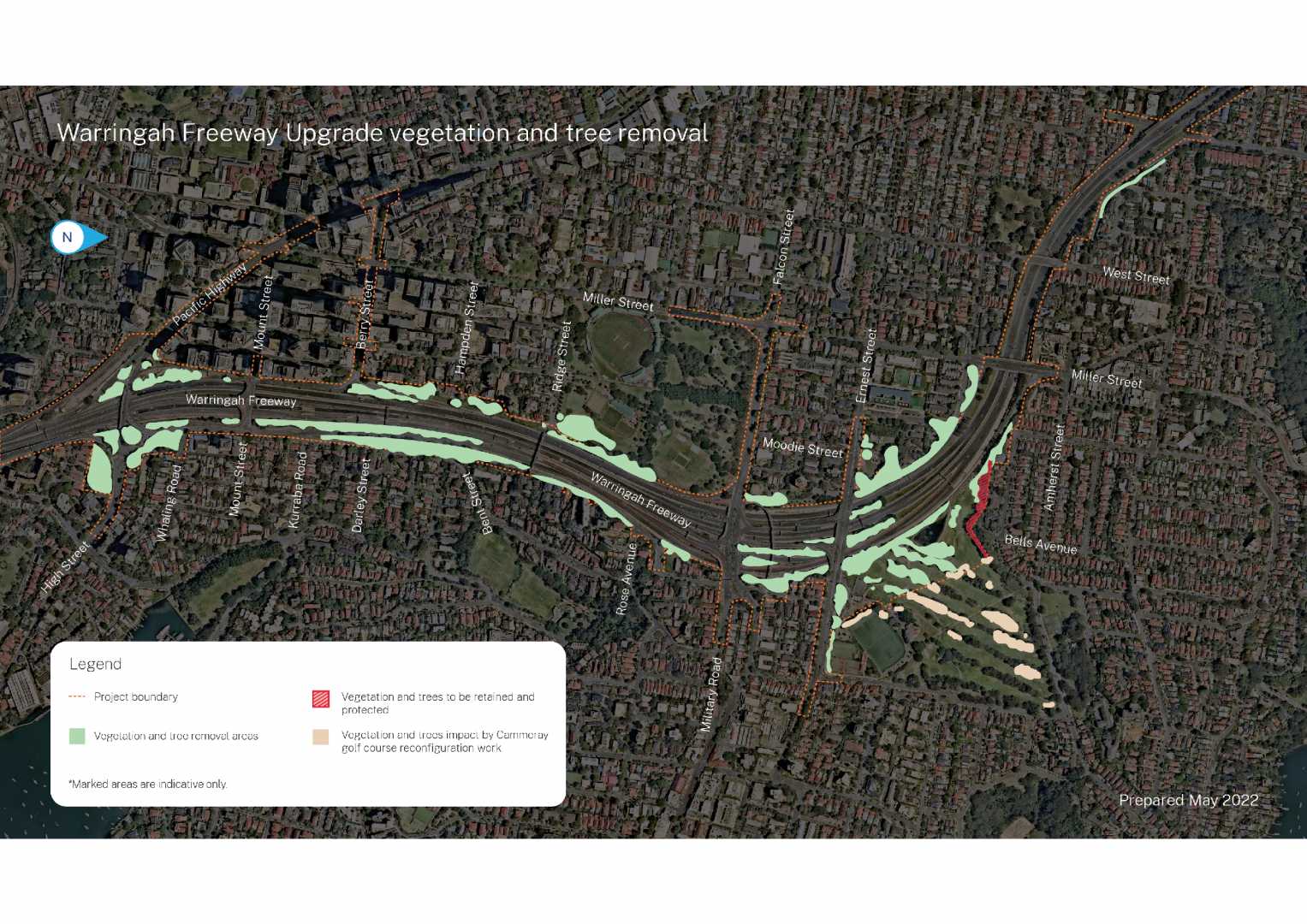
For more information on the areas where the project has approval to clear trees and vegetation, please refer to our 'Vegetation and Tree removal - frequently asked questions'.
How can the community contact the project team in relation to this work?
If you have any questions or would like to speak to a member of the project team, please get in touch with them directly on 1800 931 189 or whtbl@transport.nsw.gov.au and ask to speak to the Warringah Freeway Upgrade CPB Downer project team.
Where will we be removing trees and vegetation at Cammeray golf course?
Please refer to the vegetation and tree removal areas map below
How can the community provide feedback or report issues related to parking, project shuttle buses and traffic?
We continue to encourage residents who may see shuttle buses or workers parking in local streets to let us know directly and provide vehicle details/photos where possible. If you have further specific complaints, please call our community information line, 1800 931 189 which is available 24 hours a day and is attended during the project operation hours. Inquiries and complaints may also be received by the project email at whtbl@transport.nsw.gov.au
How can I make a complaint?
We encourage all enquiries and complaints to be directly sent to our project email at whtbl@transport.nsw.gov.au. Alternatively, please call our community information line, 1800 931 189, which is available 24 hours a day and is attended during the project operation hours.
Enquiries and complaints may also be received by post: Customer feedback Transport for NSW, Locked Bag 928, North Sydney NSW 2059.
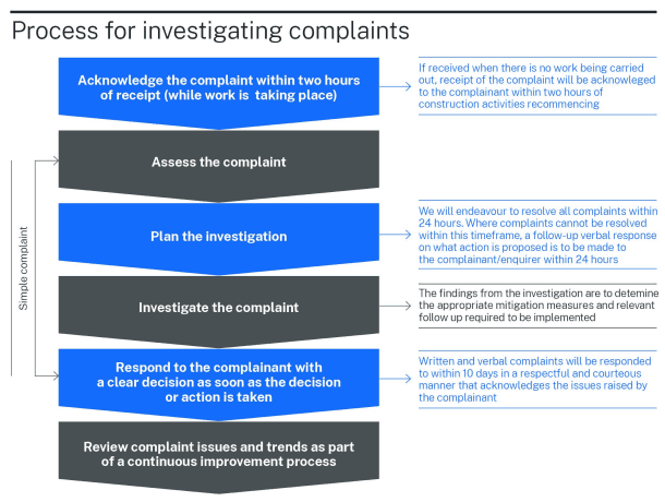
How are complaints managed?
We are committed to responding to inquiries and complaints as quickly as possible. When we receive a complaint, such as via the project email or the community information line, we will acknowledge receipt of the complaint within two hours, and endeavour to resolve the issue within 24 hours, where possible.
Our Complaints Management procedure is outlined in the project’s Community Communications Strategy, and is followed when we receive a complaint. The following information is noted:
the date and time of the complaint
type of communication (phone, letter, meeting, etc.)
the complainant's name, address, and contact information
what the complaint was about
what we did in response, including any follow-up with the complainant
who is currently handling the complaint and its status
whether the complaint was resolved or if mediation was needed
any follow-up to ensure the complaint was resolved satisfactorily
a way to escalate the complaint internally if necessary.
Will Transport consider community feedback?
Consideration about how our work affects the community plays an important role in how we carry out our activities. We take feedback and requests from the public seriously, and we consider individual complaints or requests, where reasonable and feasible, when planning our work.
During the public exhibition period for the EIS, we received 1459 submissions. Each submission received has been examined individually to understand the concerns raised and responses have been provided in the Submissions Report.
A copy of this report can be found at on the Project portal. Through the early consultation and the submissions received at that time, no major changes to the project’s design were proposed. However, community and stakeholder feedback was used to further refine the project, key activities and mitigation measures.
Contaminated land
What is land contamination?
Why are you progressing with the Beaches Link components of the Warringah Freeway Upgrade?Land contamination means chemical substances or waste are present in soil that present a potential or actual risk to health and/or the environment.
Discovering contaminants in soil does not automatically mean a site is dangerous to health. Soils can naturally contain minerals and levels which may be above what is normally expected. Some contamination also occurs naturally such as acid sulfate soils. Not all contamination affects land in such a way it cannot be used productively for industrial, commercial, agricultural, residential or other purposes and where required, soil can often be removed or treated and reused.
While contaminated soil is a potential source of harm, we can eliminate or reduce the risk associated by preventing or minimising human exposure during the construction of the Western Harbour Tunnel and Warringah Freeway Upgrade projects.
Will you disturb contaminated soil to build the project?
Soil contamination is typically caused by past industrial activity, use of agricultural chemicals, or disposal of waste, but can also occur naturally. Sydney’s industrial heritage has left potentially contaminated sites across the city and the Western Harbour Tunnel and Warringah Freeway Upgrade projects have the potential to encounter contaminated soil, rock and groundwater.
We have assessed the potential for land to be contaminated as part of the Environmental Impact Statement before starting construction so any contaminated soil can be adequately planned for. Our Contractors will be using well-established techniques to appropriately manage any contaminated land in accordance with relevant contaminated land legislation and industry standard best management practices to minimise risks and avoid potential impacts.
How will you handle contaminated soil to protect workers, the community and the environment?
The health and safety of our workers, the public and the environment is our priority and we are committed to building the Western Harbour Tunnel and Warringah Freeway Upgrade in a way which effectively manages the risks associated with land contamination.
Contractors will use well-established industry standard techniques and measures to reduce the potential for exposing workers, the community and the environment to contaminated soil or material. These measures will be outlined in the Contractor’s Construction Environmental Management Plan which will be available on the project’s interactive portal once completed.
These measures will aim to avoid disturbing contaminated soil, however, in cases when it needs to be moved or is unexpected to be encountered, these best practices will minimise the risks and impacts of the disturbance and ensure the material is handled, treated or disposed of safely and in accordance with relevant Commonwealth and NSW legislation, policy and guidelines.
All work will be carried out in line with the Ministers Conditions of Approval, Environmental Protection Licence and Construction Environmental Management Plan approved by the Department of Planning Industry and Environment.
What is the significance of future intended land use when managing contaminated land?
The future intended use of land is an important consideration when determining what types of measures are appropriate when managing contaminated land and treating the land, if required. The different types of final land use include commercial, industrial, and public open space and residential.
The main works contractor’s will be responsible for confirming the intended future final use of land within the project footprint’s when the detailed design and main works Detailed Site Investigations are complete and the outcomes of the Place, Design and Landscape Plan’s (PDLP) are available. The PDLP must be prepared by a suitably qualified and experienced person in consultation with relevant councils, the community and affected landowners and businesses. To stay up to date with opportunities to be involved with the project, please subscribe to our mailing list.
What are potential areas of environmental interest (AEIs)?
The contamination assessment completed as part of the Western Harbour Tunnel and Warringah Freeway Upgrade Environmental Impact Statement (EIS), categorised most sites within and next to the project area as representing a low risk of exposing contaminated soil during construction.
The assessment did identify eight locations within or near the project’s footprint with a moderate to high risk of exposing contaminated soil during construction. These potential areas of environmental interest (AEIs) include Rozelle Rail Yards, Easton Park, Lilyfield, Birchgrove Peninsula (including Yurulbin Park), Sydney Harbour, Balls Head peninsula, Waverton Park, unsealed areas (i.e. ground that isn’t under concrete, asphalt or other sealed surface) next to the Warringah Freeway (including St Leonards Park) and Waltham Street at Artarmon.
The risk ranking of moderate to high was based on the potential for contamination to be present and the likelihood of excavation occurring - not on the level of risk to human health or the environment. While a potential hazard has been identified in AEIs, these areas do not automatically pose a current risk to health as the soils are covered with an adequate barrier (i.e. grass).
The project team will further investigate the AEIs in accordance with the Detailed Site Investigation process before disturbing land in these areas. This will enable the project team to appropriately plan for and manage any contaminated material. More information about these locations and the types of potentially contaminated material, are provided in Chapter 16 (Geology, soils and groundwater) of the Environmental Impact Statement.
How did you identify potentially contaminated land in the Environmental Impact Statement (EIS)?
We referred to several sources and carried out site inspections during the EIS to determine the potential for land within and next to the project to be contaminated. The sources and investigations included:
historic and current aerial photographs
NSW Environment Protection Authority Contaminated Sites Register and Record of Notices
Yellow Pages business directory search
review of previous harbour sediment, soil, groundwater and contamination site investigations
visual inspections of surface areas by an environmental scientist.
The objective of these investigations was to find potential areas of environmental interest (AEIs) to help the project team identify potential limitations on construction and possible management options.
What site investigations have you undertaken to determine the potential for contamination?
Site inspections were carried out in September 2017 and April 2019 by an environmental scientist as part of the Environmental Impact Statement (EIS). Since that time, we have also carried out additional site investigations between July and September 2020. These were done to inform tenderers of the contamination and geotechnical conditions along the proposed Western Harbour Tunnel and Warringah Freeway Upgrade alignment. Further site investigations of unsealed ground will be carried out in potential areas of environmental interest (AEIs) as identified in the EIS before the ground is disturbed.
Some Detailed Site Investigations have been completed for areas near the Warringah Freeway as part of the early works program. These are available on the interactive portal.
How will the project determine if land is contaminated?
We are undertaking a two stage process to determine if land is contaminated before we start work which disturbs the ground surface. The first stage, completed as part of the Western Harbour Tunnel and Warringah Freeway Upgrade Environmental Impact Statement (EIS), identified areas with a potential moderate to high risk of exposing contaminated soil during construction. These potentially contaminated areas are referred to as potential areas of environmental interest (AEIs).
Areas which have unsealed ground (i.e. ground that isn’t under concrete, asphalt or other sealed surface) will undergo a second stage Detailed Site Investigation (DSI) by a certified Contaminated Land Consultant before the ground is disturbed. The investigations will provide further information about the extent and level of contamination in the area and recommend if further investigations are required. The DSI will include assessments of samples taken from within the project construction footprint and as such will provide an indication of the likely sub surface conditions. The DSIs are intended to enable the project team to appropriately plan for and manage contaminated material.
DSI reports have been completed by the Warringah Freeway Upgrade early work Contractor (Sydney Program Alliance) for the following areas to gather information to a level appropriate for the Warringah Freeway Upgrade early works program:
Cammeray Golf Course
Ridge Street
Rosalind Street
Arthur Street
Anzac Park
Ridge Street (St Leonards Park).
The DSI reports are currently available on the project’s interactive portal. Further Detailed Site Investigations of these areas will take place again before main works start.
What constitutes work that could disturb the ground in a potentially contaminated area?
Any work that exposes underlying soils, which could then result in direct contact with project personnel or indirectly with the public or environment via discharges (for example via dust or sediment flows) is considered by the project team to be work that could ‘disturb’ the ground.
Will Detailed Site Investigations be undertaken again before main work starts if an investigation has occurred during the early works program?
Detailed Site Investigation (DSI) reports have been completed by the Warringah Freeway Upgrade early work Contractor (Sydney Program Alliance) for a number of areas to gather information to a level appropriate for the Warringah Freeway Upgrade early work program. The Warringah Freeway Upgrade main works contractor will carry out DSI’s for all of these work areas again to assess the risk associated with their scope of works. They will also be responsible for identifying where remediation of contamination is required to complete project works, preparing a remedial action plan where remediation is required, and completing any remediation validation and Site Audit Statement(s) so any remediated land handed back upon completion of the project is suitable for its intended land use.
What potential contaminants might be present in unsealed areas next to the Warringah Freeway?
The contamination assessment carried out for the Environmental Impact Statement advised of the potential for some unsealed areas next to the Warringah Freeway to include contaminants typically associated with large traffic volumes, including hydrocarbons, pesticides, PCBs and asbestos. Detailed Site Investigations (DSI) of some unsealed areas next to the Warringah Freeway will be carried out before land in these areas is disturbed. DSI for the early works phase of the Warringah Freeway Upgrade have been completed and are available on the project’s interactive portal. Further investigations will be completed before main works begin.
Any contaminated land encountered during the construction of the project will be managed and treated using well-established techniques, in accordance with relevant contaminated land legislation and industry standard best management practices.
The health and safety of our workers, the public and the environment is our priority and we are committed to building the Western Harbour Tunnel and Warringah Freeway Upgrade in a way that effectively manages the risks associated with land contamination.
What is the process for handling contaminated material?
The first step in appropriately managing contaminated soil is to know that it is there and plan for its safe handling, by assessing the potential for contamination and undertaking detailed site investigations, if required. If contaminated soil is found, it is then classified based on the level of contamination and the physical and chemical properties of the soil.
It is then necessary to manage how the material is handled to make sure no contaminated materials are carried off-site, and workers and the community are adequately protected. All identified contamination risk areas will be managed during construction using a comprehensive suite of environmental management measures outlined in the contractor’s Construction Environmental Management Plan and in accordance with guidelines made or approved under section 105 of the Contaminated Land Management Act 1997.
If required, appropriate remediation action plans and/or environmental management plans may then be developed and implemented to remove, or suitably reduce, the contamination exposure risks during construction. Contaminated soil in small volumes may be managed under a different process. If contaminated material is removed from the site, it will be transported in sealed and covered trucks and disposed of at an appropriately licensed waste facility in accordance with the NSW EPA Waste Classification Guidelines.
What is a remediation action plan?
Remediation can involve removing, reducing or containing contamination or eliminating or reducing any hazard arising from the contamination. There are many different approaches to remediating contaminated soil and the appropriate treatments vary depending on the type of chemicals present in the soil, as well as the extent of the contamination.
A remediation action plan (RAP) outlines the measures to be taken to treat or remove contaminated material to ensure a site is suitable for its intended use. The RAP also details how any risks will be managed. This may include industry best practice dust prevention, control and suppression measures to manage and minimise the impacts of dust emission, minimising the extent of spoil stockpiles and revegetating or sealing areas of disturbed soil as soon as practicable.
During early works, the contractor will remove contaminated soil, make good any areas that have been disturbed and identify them for the main works contractor.
Once the final future use of land within the project footprint is confirmed, the main works contractor will obtain a Site Audit Statement from a NSW Environment Protection Authority accredited Site Auditor before starting any soil remediation work. This will certify the RAP is appropriate and the site can be made suitable for use. The Site Audit Statement and its accompanying Site Audit Report will be submitted to the Department of Planning, Industry and Environment and Council after the contaminated material is remediated.
What safety procedures will be in place if you remediate a site?
Remediation of a site, if required, will occur during the main works program. Remediation can involve removing, reducing or containing contamination or eliminating or reducing any hazard arising from the contamination.
The health and welfare of our workers and the public, and protecting the environment is our priority and all work will be managed in accordance with NSW and national health and safety requirements. Strict safety procedures will be followed during the work which may include:
Capturing contaminated material onsite or transporting and disposing it at licensed facilities
Workers wearing personal protective equipment such as face masks and bodysuits
Monitoring air quality where required
Using signs, barriers and temporary fencing to delineate contaminated areas
Using water sprayers, water carts or soil binders to suppress any dust created by the work.
Where is contaminated soil disposed?
The levels and mobility of chemical compounds in contaminated soil can render it hazardous waste, preventing it from going to landfill. This triggers a requirement for the soil waste to be disposed of at a licensed facility that can lawfully receive or treat it to lower the levels of contamination or immobilise the contaminants.
While most of the soils encountered on the project will be clean, some material is anticipated to be contaminated as a result of previous industrial activity. Where required, this waste will be disposed of at facilities licensed to accept the waste or to a treatment facility that can reduce the concentrations of contaminants prior to disposal.
What will you do if you find unexpected contaminated material in an area being used for construction?
Many kinds of unexpected materials can be encountered during excavation works including buried waste, discoloured and odorous soils and asbestos. These unexpected finds are likely to be associated with poor waste disposal and/or construction activities undertaken historically at the site.
Because the potential for encountering unexpected contamination exists in every project involving excavation, the project team have prepared an unexpected finds procedure to follow in these scenarios.
In the event that previously unidentified contaminated material is discovered, all relevant work would stop near the discovery and the unidentified contaminated material would be managed in accordance with the unexpected finds procedure.
Material which displays some or all of the following characteristics will be considered by the project team as possibly contaminated and will trigger the unexpected finds procedure:
unusual odour from soils that are not detected in other similar areas
discolouration or staining of soil or rock
seepage of unusual liquids from soil or rock
unusual odours, sheen or colour on groundwater and/or surface water
unusual metal objects
unexpected underground storage tanks, buried drums or machinery
presence of waste or rubbish above or below ground
potential asbestos containing material.
The Contractor’s Construction Environmental Management Plan (CEMP) will also consider the potential for odorous soil to be encountered during any subsurface excavation work and specify appropriate procedures to minimise odour generation and/or exposure including containing and removing the material. No former waste landfills are proposed to be excavated to build the project, limiting the potential for significant emissions of landfill gases and associated odours during construction. Refer to the Early Works CEMP for more information.
Are there structures or building located within the project areas that could contain hazardous building materials?
If structures and/or buildings need to be demolished to enable construction, any hazardous building materials would be managed in accordance with Australian Standards to reduce the potential for contamination and ensure the waste is handled and disposed of safely. Demolition works will be carried out in accordance with the relevant Australian Standards and relevant NSW WorkCover Codes of Practice, including the NSW Work Health and Safety Regulation 2011.
How will the early work activities be regulated during construction?
The early work activities have been issued an Environment Protection Licence (EPL) for road construction under the Protection of the Environment Operations Act 1997. All our work will be carried out in line with the EPL, Ministers Conditions of Approval (CoA), and Construction Environmental Management Plan (CEMP), overseen by the Department of Planning Industry and Environment (DPIE) and NSW Environment Protection Authority (EPA).
Consistent with the Contaminated Land Management Act 1997, the EPA will regulate any contaminated sites where the contamination is significant enough to warrant regulation.
What is a Construction Environmental Management Plan?
Our work must be carried out in line with the environmental management measures specified in the Construction Environmental Management Plan (CEMP) overseen by the Department of Planning, Industry and Environment (DPIE), the Environment Protection Authority (EPA) and an independent Environmental Representative.
The CEMP has been reviewed and approved by DPIE and the independent Environmental Representative, prior to the commencement of construction activities on-site. A waste management procedure for the project has be prepared as part of a CEMP prior to construction. The plan also includes waste management measures and procedures for managing unexpected finds and handling and storing all project spoil, including potentially contaminated substances.
Potential construction impacts on water quality
How will you manage the potential for erosion and runoff during construction?
Construction activities associated with building support sites and upgrading surface roads typically involve excavation and earthmoving, which can temporarily expose soil to wind and rain. Our contractors will use a comprehensive suite of erosion and sediment management and mitigation measures at all work sites to manage the potential for exposed soil to be carried offsite.
Erosion and sediment measures will be implemented in accordance with the principles and requirements outline in Managing Urban Stormwater – Soils and Construction, Volume 1[1] and Managing Urban Stormwater: Volume 2D Main Road Construction[2], commonly referred to as the ‘Blue Book’, and relevant Transport for NSW guidelines, procedures and specifications. Management of erosion and sediment for major construction projects in accordance with the Blue Book is well known, tried and proven.
A soil conservation specialist will also be engaged by both Transport for NSW and the Contractor for the duration of construction to provide advice regarding erosion and sediment control measures including review of Erosion and Sediment Control Plans.
The health and safety of our workers, the public and the environment is our priority and we are committed to building the Western Harbour Tunnel and Warringah Freeway Upgrade in a way that effectively manages the potential for erosion and runoff.
Potential construction impacts on air quality
What is the potential for dust and exhaust emissions from construction activities?
We know how important it is to manage the potential impact of construction on air quality and we will have measures in place to minimise dust and will monitor air quality every day.
As with any building work, creating dust is unavoidable, however we will have an experienced construction team who will work to minimise impacts. They will use effective dust suppression methods including stabilising loose material, watering the site and covering material when it is transported in trucks. We will be monitoring dust around our work sites to ensure our methods are allowing us to meet the limits of our Environment Protection Licence and inform us if we need to make changes.
Minor exhaust emissions from plant and equipment is also common on construction sites These emissions will be effectively managed with standard environmental management measures, like truck marshalling areas to minimise potential queueing and traffic near construction support sites, and are unlikely to have a noticeable impact on the surrounding environment. More information about our air quality management measures is available below.
How will you be minimising potential construction impacts on air quality?
Construction to build the Western Harbour Tunnel and Warringah Freeway Upgrade will be carried out under an Environment Protection Licence (EPL), issued by the NSW Environment Protection Authority (EPA) which will include limits relating to air quality and dust. When we are building, we will be monitoring dust around the sites to ensure our methods are allowing us to meet the terms of our EPL and inform us if we need to make changes.
Our work must also be carried out in line with the environmental management measures specified in our Construction Environmental Management Plan (CEMP), overseen by the Department of Planning, Industry and Environment, the EPA and an independent Environmental Representative. The CEMP has been reviewed and approved by the Department of Planning, Industry and Environment and the independent Environmental Representative, prior to the commencement of construction activities on-site.
Some of the standard construction air quality mitigation and management measures to implemented during construction include:
reasonable and feasible dust suppression and/or management measures, including the use of water carts, dust sweepers, sprinklers, dust screens, site exit controls (e.g. wheel washing systems and rumble grids), stabilisation of exposed areas or stockpiles, and surface treatments
Selection of construction equipment and/or materials handling techniques that minimise the potential for dust generation
selection of construction equipment and/or materials handling techniques that minimise the potential for dust generation
adjustment or management of dust generating activities during unfavourable weather conditions, where possible
minimisation of exposed areas during construction
internal project communication protocols to ensure dust-generating activities in the same area are coordinated and mitigated to manage cumulative dust impacts of the project
site inspections to monitor compliance with implemented measures.
To further mitigate potential cumulative project impacts, additional measures may include coordinated scheduling of construction activities and deliveries and data sharing.
To further mitigate potential cumulative project impacts, additional measures may include coordinated scheduling of construction activities and deliveries and data sharing.
Potential construction impacts on silica exposure
What does Transport for NSW do to ensure workers are safe on its construction projects?
The health and safety of every worker on our projects is our first priority.
Transport for NSW and contractors performing work on behalf of Transport are required to comply with all relevant workplace laws.
Our construction partners have strict health and safety measures in place designed to protect workers from silica exposure.
They are contractually, and under statute, are required to meet these strict health and safety requirements.
Have there been any cases of silicosis in workers on the Western Harbour Tunnel and Warringah Freeway Upgrade projects?
We are not aware of any notifications having been received for a silicosis diagnosis for any worker on both projects.
We take our commitment to workers extremely seriously. Health and Safety is our number one priority. Strict controls are in place to eliminate risks and to protect workers.
What is the government doing to address the issues of silica dust diseases in tunnelling?
On 3 March, the government announced the formation of an Expert Taskforce to oversee and help address silica-related health risks for workers in tunnelling.
It will focus on four broad areas:
Better use of data with more transparent access
Improved health monitoring
Review and revise best practice Work Health and Safety controls
Enhanced compliance
Why is out-of-hours work scheduled over the weekend?
There are two main reasons why we undertake weekend out of hours work:
1. The most common reason is when traffic lanes are required to be closed outside of peak traffic periods. Work that cannot be completed during reoccurring single night work shifts will be carried out over weekends. This will include installing bridge girders that require cranes to be parked on temporarily closed traffic lanes for more than 7 continuous hours, greater than the time allowed during a single night work shift.
2. When there is an opportunity to schedule out-of-hours work in a more productive way or lessen the impact of the work on the surrounding community, we change the work schedule from weeknights to weekends. Weekend work can be undertaken to increase construction productivity, ultimately lessening the duration of construction impacts on neighbouring communities. More productive work can be undertaken over continuous weekend shifts of 24, 36 or 56 consecutive hours when compared with ongoing single night work shifts on weeknights. An example of how this is applied during construction is provided on the next slide.
Please note: some work cannot be completed on weeknights, this is because the time we are permitted to have traffic changes in place on a weeknight is too short to complete the required work. An example of this will be when we lift large bridge girders into place for new and widened bridges spanning the freeway.
What hours will you work during weekend work?
The duration of each weekend of work will vary depending on factors such as the scope and complexity of the work to be completed and the traffic approvals that outline the amount of time that we can temporarily close traffic lanes for, and at what time.
Weekend work will include continuous blocks of work, traffic changes can be put in place for longer durations than is permitted during weeknights. Blocks of work may be:
12-hour periods - 9pm Saturday to 9am Sunday
24-hour periods - 9pm Saturday to 9pm Sunday
36-hour periods - 9pm Friday to 9am Sunday
56-hour periods - 9pm Friday to 5am Monday.
Will night work take place on weeknights in addition to on weekends?
When we work over a weekend, we will not schedule high noise impact work for two nights prior to, and two nights following, the weekend work in the same area. We will work up to 10 nights per month in each area over a combination and weekday and weekend out of hours work shifts.
Are residents living near the weekend work area provided with anything to help them to manage construction noise impacts?
Residents living directly adjacent to weekend work areas may be eligible for a respite offer, examples of respite offers include:
the offer of an audio sleeping eye mask with Bluetooth speaker connectivity to assist with creating a better sleeping environment during the weekend night work
the offer of a respite voucher to assist with the cost of spending a short time away from the construction impacts near your home during daytime weekend work, including at the cinema, a café or retail outlet.
How are community members informed about out-of-hours work?
The communication tools used to inform the community about schedule weekend work include:
direct contact via door knocking and scheduled meetings with stakeholders and Strata representatives
tailored ‘Sorry we missed you’ card letterbox drops with project team contact information for stakeholder not home at time of doorknocking attempts
direct phone/email to building management/Strata
information posters installed at property noticeboards and on street poles next to the work area
distribution of community notification material in letterboxes
project emails and/or text messages to community members and stakeholders subscribed to the project distribution lists
Warringah Freeway Upgrade online portal updates
Temporary and permanent variable message signage (VMS) on the freeway and on local streets.
What mitigation measures are in place to manage heavy vehicle idling and queues on public roads?
To manage heavy vehicle idling and queues on public roads, we have implemented the following measures:
Preparation of E132 Local Roads Plans for the use of any local roads to access the construction boundary that are not included in the EIS
Preparation and implementation of site Vehicle Management Plans (VMP) for use of local roads and their inclusion in the TTAMP
Real time monitoring using the geospatial database Virtual Superintendent to track spoil trucks on the Project
Managing vehicle movements, including manual supervision, physical barriers, temporary traffic signals and changing existing signals to ensure pedestrian, cyclist and motorist safety.
Why is High Street being upgraded?
The NSW Government’s vision for Sydney is one of an integrated road and public transport network that gives you the freedom to choose how and when you get around, no matter where you live and work.
The Warringah Freeway Upgrade is a major transport infrastructure project that will make it easier, faster and safer to get around Sydney. By creating a western bypass of the Sydney CBD, the Western Harbour Tunnel will take pressure off the Sydney Harbour Bridge, Sydney Harbour Tunnel, ANZAC Bridge and Western Distributor corridors to improve transport capacity in and around Sydney Harbour.
As part of the Warringah Freeway Upgrade, we will be upgrading the High Street interchange to improve connectivity and safety in the area as the Northern Sydney community continues to grow. This includes widening of the existing High Street bridge, building new and improved on/off ramps and a new signalised intersection.
The High Street interchange is being upgraded to cater for anticipated higher westbound traffic volumes as a result of the new northbound ramp to the Warringah Freeway from High Street; while also addressing existing issues at the High Street / Alfred Street North roundabout by converting to traffic signals. The upgrade is to improve current eastbound traffic flow into Kirribilli / Neutral Bay.
What are the key features of the High Street Interchange?
Key features of the High Street Interchange include:
upgrade and widening of the existing High Street bridge for additional traffic lanes to provide improved capacity into North Sydney via the Pacific Highway. The widened bridge would consist of new girders and a deck superstructure on piers with footings which will match existing locations
a new on ramp from the interchange to the Warringah Freeway northbound
an upgraded off ramp connection from the Warringah Freeway southbound, with associated upgrade works along Alfred Street North
conversion of the existing High Street/Alfred Street intersection to a signalised intersection
a new access to/from Whaling Road via Alfred Street North.
new and upgraded active transport infrastructure around the interchange
A map of the High Street Interchange can be found in Chapter 5 Project description - Page 51 of the Environmental Impact Statement (EIS).
Why can't you keep the roundabout?
Transport for NSW plans to upgrade the Alfred St North / High Street intersection from priority control roundabout to traffic signals to improve safety and efficiency as the North Sydney CBD and surrounds continues to grow. It is our responsibility to ensure the project we are designing will operate safely and efficiently for a design year of 2037, which includes 15 years of planned land use development and growth.
Roundabouts have capacity limitations and the forecasted traffic volumes at this location have indicated this would exceed the roundabout’s ability to function efficiently.
What are the key benefits of the High Street Interchange?
Some of the key benefits of this upgrade include:
provides local connectivity into North Sydney, to the north and west, and Kirribilli, to the east
maintained connection from the Pacific Highway to and from the north-west (via High Street) to Kirribilli to the east
A new northbound connection to the Warringah Freeway
Improved connectivity via two south-facing ramps and two north-facing ramps
Two south-facing ramps providing: − An off ramp connection from the Bradfield Highway northbound to the Pacific Highway and Arthur Street northbound − An on ramp connection from High Street to the Cahill Expressway southbound
Two north-facing ramps providing: − An off ramp connection from the Warringah Freeway southbound via Alfred Street North to High Street (eastbound and westbound) − An on ramp connection from High Street (eastbound and westbound) to the Warringah Freeway northbound.
A map of the High Street Interchange can be found in Chapter 5 Project description - Page 51 of the Environmental Impact Statement (EIS).
How will I use the High Street Interchange once complete?
Please watch our short video on the travel options while using the High Street Interchange.
You can also view the High Street Interchange map located in Chapter 5 Project description - Page 51 of the Environmental Impact Statement (EIS).
Who will be building the High Street Interchange?
The Warringah Freeway Upgrade main works contractor, CPB Downer Joint Venture will be building the High Street Interchange.
What is the High Street south temporary construction support site?
High Street south temporary construction support site
The High Street south temporary construction support site is located within the Warringah Freeway corridor at North Sydney on land bound by the Cahill Expressway to the west and south, the High Street off ramp to the east, and High Street to the north. The site is planned to be built before the end of 2022 and will be used for the duration of construction of the Warringah Freeway Upgrade.
This site in addition to the High Street North and Arthur Street East temporary construction support sites is being used to support construction activities for the High Street interchange upgrade, including bridge and surface works, as well as for the widening and surface works in the southern portion of the Warringah Freeway Upgrade.
General site activities will be carried out during standard construction hours from 7am to 6pm Monday to Friday and from 8am to 1pm Saturday. Some construction activities (e.g bridgeworks and surface works) supported by this site would require out of hours work. This means that there would be periods throughout the construction program where works at this site would occur outside of standard construction hours. Access in and out of the site would be via High Street.
Any out of hours works the community are advised in advance through our community notifications and construction notifications map.
To find out more about this site, please refer to Chapter 6 Construction work of the Environmental Impact Statement.
What is the High Street north temporary construction support site?
High Street north temporary construction support site
The High Street north temporary construction support site is located within the Warringah Freeway corridor at North Sydney on land bound by Alfred Street North/Cahill Expressway to the west and High Street to the north, south and east. The site is planned to be built before the end of 2022 and will be used for the duration of construction of the Warringah Freeway Upgrade.
The construction support site is being used to support construction activities for the High Street interchange upgrade, including bridgeworks, as well as for the widening and surface works in the southern portion of the Warringah Freeway Upgrade.
General site activities are being carried out during standard construction hours from 7am to 6pm Monday to Friday and from 8am to 1pm Saturday. Some construction activities (eg bridgeworks and surface works) supported by this site would require out of hours work. This means that there would be periods throughout the construction program where works at this site would occur outside of standard construction hours. Access in and out of the site would be via Alfred Street North to the north or Pacific Highway via High Street to the west.
To find out more about this site, please refer to Chapter 6 Construction work of the Environmental Impact Statement.
To learn more about the High Street interchange upgrade, please refer to Chapter 5 Project Description of the Environmental Impact Statement (EIS).
What is ITS?
Intelligent Transport Systems (ITS) uses technology such as information sharing, communication and data processing technologies that manage the transport system. They use digital dynamic signage to deliver clear and up to date information to all road users, making it safer for road users, reducing congestion and traffic incidents.
What is a Smart Motorway?
A Smart Motorway uses real-time information, communication, and traffic control systems to improve traffic flow.
Variable road signs and messages communicate to drivers how to best travel along the freeway for a safer, more consistent, and less congested journey.
What are the benefits?
Current information about traffic conditions – Drivers will be able to see real time information on message boards to help them make informed decisions about their route before and during their trip on the freeway
Improve traffic safety – If there is an incident, variable message signs will indicate the safest speed and which lanes are to be used. These variable signs help improve access for safety crew and emergency vehicles.
Reduced vehicle emissions – When traffic flow is improved and there is less stop-start driving, vehicles have better fuel consumption and produce fewer emissions.
Improve travel time and reliability – Provide faster journeys and reduced variability in travel times for current and future users of the corridor.
This means real time responses for traffic on the Warringah Freeway, allowing road users to avoid congestion on the freeway with less stop-starting and more reliable travel times. Less stop-starting will reduce accidents.
We are also able to respond to any incidents using automatic incident identification technology and, when necessary, allow vehicles to continue to move around incidents.
How many signs will be installed?
Up to 14 gantries are being installed between the Sydney Harbour Bridge and Willoughby Road overpass, others will be upgraded. These gantries will have Integrated Speed Lane Usage electronic signs, automatic incident detection technology, vehicle detection, extensive CCTV coverage and variable message signs along the corridor.
What is a gantry and what do they look like?
A gantry is a large structure that sits over a roadway, typically made of steel or concrete. They are used to support traffic management devices, such as signage, electronic message boards, variable speed limit signs, lane control signals, cameras and sensors.
Gantries on freeways typically span across multiple lanes of traffic and are positioned strategically along the freeway to provide important information to drivers and help manage traffic flow efficiently.
Gantries can vary in design and appearance depending on factors such as the specific purpose of the freeway, regional standards, and aesthetic considerations. However, they typically have a distinctive look characterised by their size, robust construction, and the array of equipment mounted on them.
Where will the new gantries be located?
There will be several new gantries along the freeway and some in the surrounding streets. New gantries will be installed at High Street, Berry Street, Ernest Street and Miller Street.
A project map for these locations and other signage to be installed or replaced will soon be available on the project portal. In the meantime, if you have any questions, please reach out to the project team via the project email at whtbl@transport.nsw.gov.au. Alternatively, please call our community information line, 1800 931 189, which is available 24 hours a day and is attended during the project operation hours.
How do you decide which sign goes in which location?
The size and location of the signage has been selected in accordance with Sydney Smart motorway guidelines which is set by Austroads Standards and Guide to Traffic Management. Unfortunately, there is no room to consult on this as minimum standards are required to be met.
All signage must be positioned so that road users have time to respond to the messages provided, and therefore should be positioned an adequate distance in advance of major decision points.
A map will be available on the project portal shortly for locations.
How will we build them?
We have started to install smart motorway technology on the Warringah Freeway between the Sydney Harbour Bridge and Willoughby Road overpass.
To date, our work has focused on preparation activities, including site investigations, and installing cabling and control cabinets (nodes). We are now starting to erect new signage and install other smart motorway technology on the Warringah Freeway. At times we will need to partially close sections of the Warringah Freeway to install gantries and signage. We will complete most of our work at night when traffic is at its lowest and detours will be in place at times.
We will be continually working on this installation from now until 2026 and work will be notified in each area as we progress.
How will will this impact you?
During the process of upgrading the Intelligent Transport Systems (ITS) along the Warringah Freeway, some of the existing devices will either need to be improved or taken out altogether, and in certain locations, we will need to install brand-new equipment.
While this work is happening there might be some noise caused by the construction due to the site preparation and trenching work and once the new hardware is in place, it may also change how things look along the freeway.
What project documents were prepared to manage parking impacts and heavy vehicle management?
We acknowledge the availability of on-street parking is important to local residents, and the impact our project has around our worksites.
To minimise these impacts as much as possible, and meet compliance with the Minister’s Conditions of Approval (MCoA), the Project needed to prepare multiple management plans to outline how the project would be delivered. The following plans have been prepared to assess and manage the impacts related to parking and vehicle management for the Warringah Freeway Upgrade:
1. Construction Parking and Access Strategy (CPAS) (CoA E140)
The CPAS identifies and proposes mitigations for impacts caused by on- and off-street parking changes during the construction phase of the Project. The CPAS is the only plan that identifies and assesses these changes, manages parking and outlines mitigations during construction.
The CPAS is an iterative document, updated by the project following any temporary changes to parking that are required during the Project’s delivery. Residents will be consulted on any additional changes to parking and future updates to the CPAS.
The most recent CPAS for the North Zone (Rev 4 - Revised September 2025) was approved by the Department of Planning, Housing and Infrastructure (DPHI – formerly DPE) on 9 August 2023 and is available on the Project portal here.
The most recent CPAS for the South Zone (Rev 11) was approved by DPHI on 25 November 2025 and is available here.
2. Transport, Traffic and Access Management Plan (TTAMP)
The TTAMP was prepared as part of the Project’s Construction Environmental Management Plan (CEMP). It is required by the MCoA and describes how the contractor will manage potential traffic impacts, transport and access issues during construction. The main goals are to minimise traffic impacts, including delays, while considering the needs of all road users and ensuring safety for workers and the community.
The latest revision of the WFU Stage 2 TTAMP (Rev 6) was endorsed by the Project Environmental Representative and approved by DPHI on 8 April 2022. You can find it here.
3. Local Road Plan (MCoA E132)
Wherever possible, we require our workforce to use main roads to access and leave our construction sites, however due to the location of certain sections of the project, access is only available by local roads.
This document outlines and manages our use of any local road to access the construction boundary that was not included in the EIS, in accordance with MCoA E132. There are currently two Local Road Plans for the Project:
Cammeray Precinct, approved by DPHI on 4 December 2022. Link
Falcon Street Active Transport Bridge, approved by DPHI on 9 August 2023. Link
What is the process for removing parking spaces during construction?
We are required to remove the fewest number of on-street parking spaces required for our project. Due to the constrained urban environment where our Project is located, unfortunately has required the temporary removal of on-street parking on some local roads.
The process for temporarily removing parking spaces during construction includes:
identifying the need to temporarily remove parking to allow for the construction of the Project
consulting with affected stakeholders on the proposed removal of parking
considering stakeholder feedback and development of appropriate mitigation measures
assessing parking removal impacts via the CPAS as per MCoA E140
submitting the CPAS to the Department of Planning, Housing, and Infrastructure (DPHI) for their review and approval
implementing mitigation measures prior to removal of parking
reinstating parking once construction works are complete.
We ensured parking was made available for residents for as long as possible before we removed the spaces required to deliver the project, and we will reinstate the parking as soon as possible.
What measures have been implemented to minimise workers parking on local roads?
We acknowledge the availability of on-street parking is important to local residents, and the impact our project has around our worksites.
To minimise the number of workers parking on local roads, we have the following measures in place including:
instructing workers not to use on-street parking during their employment on the Warringah Freeway Upgrade
distributing emails to employers and managers to communicate this instruction to their team members
installing signage in the area to remind workers not to park on local roads
conducting regular inspections to monitor compliance with parking instructions in local streets
placing notices on identified worker vehicles to remind workers of their commitments not to park on nearby local roads
encouraging residents to send photographs of workers’ private vehicles parked on local roads, which we investigate with relevant managers
working with North Sydney Council to ensure fines are issued to anyone parked illegally
communicating regularly with the site team about public transport options, the use of our shuttle bus service, and available parking at surrounding work sites during daily pre-starts and toolbox briefings.
In addition to the above mitigation measures, the Project currently has a Project shuttle bus in operation. The buses transport workers to and from North Sydney station, St Leonards station and approved Project locations.
Our Project shuttle buses are not approved to pick up or drop off workers from local streets.
The Project team is working on renting additional parking space in Artarmon and adding this site to the shuttle bus route.
A site on Wicks Road was approved for Project use in February 2024, and is currently being set up to provide additional parking spaces for workers. The shuttle bus will be scheduled to transport workers between this site and work sites.
Is parking provided for workers on the project?
Onsite parking has been provided across the Project areas to help minimise impacts from the large workforce required for both Warringah Freeway Upgrade and Western Harbour Tunnel. The on-site parking allocated for those working on Warringah Freeway Upgrade and Western Harbour Tunnel is limited due to the constrained urban environment around our construction sites.
While workers are legally allowed to park near their place of work while abiding by local road regulations, we acknowledge our workforce in the area from the Warringah Freeway Upgrade and Western Harbour Tunnel places an increased demand on local on-street parking spaces. Transport and our delivery partners are strongly committed to working with DPHI a to minimise workers parking on local roads wherever possible.
The MCoA do not prohibit workers parking on local roads, but stipulate that the Project must minimise worker parking on public roads (MCoA 139(a)).
The Project helps minimise impacts on the public roads by providing parking facilities where ancillary facilities are located, encouraging our workforce to use public transport by offering a shuttle bus service from bus and train hubs and regularly communicating with our staff to discourage them from parking on local roads.
Off-street parking for workers is identified in Section 5.4 of CPAS North Zone (Rev 2) and Section 5.4 of CPAS South Zone (Rev 11). Off-street parking is provided for the Project workforce at the following locations:
Wicks Road Ancillary Facility (WFU10)
Rosalind Street Compound (WFU9)
Cammeray Golf Course (WFU8)
High Street South Compound (WFU2)
Arthur Street East Compound (WFU4)
Ward Street Council Car Park
Ridge Street Council Car Park
What mitigation measures are in place to manage impacts of parking removal?
Mitigation measures the Project has implemented to manage parking removal impacts include:
consulting with affected residents and other stakeholders on the proposed removal of parking
staging the removal and reinstatement of on-street parking where feasible to minimise the overall time the parking is removed
working with relevant council(s) to introduce and/or change parking restrictions adjacent to work sites, compounds or appropriate residential parking schemes. The project continues to work with North Sydney Council regarding residential parking schemes. No new and reallocated permits can be implemented due to capacity in these zones.
managing worker parking arrangements to minimise impacts on public parking areas – refer to CPAS North Zone (Rev 2) and CPAS South Zone (Rev 11) for evidence of worker parking arrangements.
instructing workers to park within work sites, or ancillary facilities, where feasible
communicating regularly during daily pre-starts and toolbox briefings with the site team about public transport options, the use of our shuttle bus service, and available parking at surrounding work sites.
In addition to the above mitigation measures, the Project staff undertake regular monitoring to assess the effectiveness of the CPAS on roads that are impacted by long-term temporary removal of on-street parking. Inspections involve the following:
confirmation that where alternative parking arrangements have been provided, these are being implemented
monitoring of the impacts of the removal of on-street parking on surrounding roads
inspections for the presence of construction workforce parking on local roads.
The results of this monitoring are included in the three-monthly CPAS Monitoring Report (as prescribed by MCoA E140(k)) which is submitted to DPHI. These monitoring reports are made publicly available on the Project website once accepted by DPHI.
How can the community provide feedback or report issues related to parking, project shuttle buses and traffic?
We continue to encourage residents who may see shuttle buses or workers parking in local streets to let us know directly and provide vehicle details/photos where possible. If you have further specific complaints, please call our community information line, 1800 931 189 which is available 24 hours a day and is attended during the project operation hours. Inquiries and complaints may also be received by the project email at whtbl@transport.nsw.gov.au.
Why are property condition surveys being carried out?
A property condition survey is a best-practice construction process offered on most major infrastructure, building and development projects.
The survey is carried out to provide a record of the condition of the existing building or structure at a particular moment in time.
The survey is a precautionary measure which provides a basis for any future discussions which may be required between private property owners and project teams, regarding real or perceived changes in property condition observed while construction was taking place.
Property owners should note major construction projects are governed by stringent environmental management processes which manage construction impacts, such as vibration, in accordance with industry best practice. This minimises the risk of any cosmetic or structural damage occurring to surrounding buildings or structures as a result of construction work.
How do we identify properties eligible for a property condition survey?
Property eligibility for a preconstruction property condition survey is typically based on the distance of the property to the construction work area considering:
ground conditions
type of work (e.g., digging, trenching, compacting)
plant and equipment being used to complete the work
potential vibration and/or settlement resulting from the work.
Why has your property been identified?
Our assessments have concluded that:
properties within 50 metres of the project boundary
will be offered a property condition survey, and
for multi-storey buildings, the basement, ground, first and second floors are eligible for a property condition survey.
When will you get a property condition survey?
We are staging our work to reduce, minimise and effectively manage the impacts of some unavoidable disruptions on the community, including commuters. Property condition surveys will be carried out on eligible properties before work starts near them.
As we will have different phases of work, activities and contractors your property may be eligible for multiple property condition surveys. Property owners will be contacted directly as required on each and every occasion.
We encourage you to support the facilitation of these free surveys to provide you with the most insurance against any potential damages caused by the work.
Who will carry out the property condition survey at my property?
The property condition surveys are being carried out by an independent assessor who is suitably qualified and experienced in the field of property condition surveys. As the assessor is independent, they hold no bias towards either the property owner or the project team.
What will the property condition survey involve?
Upon agreement by the property owner/strata manager, the independent assessor will enter the property at a pre-agreed data/time to carry out the property condition survey.
The property owner or nominated representative of the property owner (e.g. real estate agent, strata manage, building manager or tenant), is requested to be present for the duration of the survey.
The assessor will inspect the exterior and/or interior of the building or structure including sheds, driveways, pathways, swimming pools, fences and retaining walls. Photographs and/or video footage will be taken of all areas available for observation. Photographs give an accurate picture of the condition of the buildings at the time of inspection.
The property condition survey inspection typically takes 30 minutes to 2 hours to complete depending on the size of the property area to be surveyed.
Why is it important that I have a condition survey?
The survey is optional; however, we encourage property owners to have a survey completed. Property condition surveys gather baseline data on the property before any work takes place.
If you do not have a property condition survey prior to work starting, then the project team has no basis for comparison is the unlikely case that damage is incurred during construction.
Any claims or concerns can be responded to more quickly if there is a record of your property condition prior to the start of work. We encourage you to have a property condition survey as it provides you with the best insurance against any potential damages caused by the work.
How do I agree to provide access to my property?
To provide access to your property, please complete the online Property Access Agreement Form. The form can be found:
caportal.com.au/rms/wfu-paaf or by using the QR code overleaf
This is to give the Transport for NSW contractor permission to access your property. It will help us to minimise any disturbance to you and enable us to address any special considerations of entry onto your property.
Once we receive the completed online form, we will be in contact to schedule an appointment at a time and date convenient to you.
If you would prefer a hardcopy form, please contact the project team on 1800 931 189 or projectteam@cpbdownerjv.com.au and we will arrange for it to be delivered to your property.
Will I receive a copy of the property condition survey report?
Yes. Once the property condition survey report has been compiled, a copy will be emailed to the property owner. Hard copies of the property condition survey report can be provided on request. Please contact the project team on 1800 931 189 or projectteam@cpbdownerjv.com.au and we will arrange for it to be sent by registered post.
The report usually takes around four weeks to be completed.
If you are the property owner’s representative (e.g. real estate agent, tenant), you will need to contact the property owners to request a copy of the property condition survey report.
Who else will receive a copy of the property condition survey report?
Copies of the property condition survey report of your property will be kept and stored in accordance with Australian privacy and security guidelines by Transport for NSW and their contractor.
For multi-unit dwellings, reports for external and shared /common spaces will be provided to the strata manager and to the Owners Corporation. These parties can distribute to individual owners at their discretion.
In keeping with privacy regulations, Transport for NSW will not provide the strata manager or the Owners Corporation with reports of individual properties. Copies of reports for individual properties will need to be requested by property owners directly.
What should I do if I believe the contents of the property condition survey report are inaccurate?
If you believe any information contained in the property condition survey report is inaccurate, please contact the project team immediately to discuss.
The project team will raise your concerns with the independent assessor and contact you regarding the next steps. Should the property condition survey report for your property need to be revised and reissued, the team may need to coordinate for your property to be re-surveyed.
Will my property be reinspected after the work has been completed?
Yes. Once Warringah Freeway Upgrade main work has been completed a post-construction property condition survey will be carried out.
Once the property condition survey report has been compiled, a copy will be emailed to the property owner. Hard copies of the property condition survey report can be provided on request. Please contact the project team on 1800 931 189 or projectteam@cpbdownerjv.com.au and we will arrange for it to be sent by registered post.
What if my property is damaged?
Please contact the project’s community team if you believe you have damage to your property as a result of our work. We will investigate your claim and work with you to address any concerns. If our contractor has damaged your property, we will fix the damage at no cost to you.
If I didn't accept the offer for a property condition survey and I notice damage, what do I do?
Please contact the project team with any property claims or concerns on 1800 931 189 or projectteam@cpbdownerjv.com.au If you do not have a property condition survey prior to work starting, then the project team has no basis for comparison in the unlikely case that damage is incurred during construction.
Any claims or concerns can be responded to more quickly if there is a record of your property condition prior to the start of work. We encourage you to have a property condition survey as it provides you with the best insurance against any potential damages caused by the work.
Why haven't I been offered a property condition survey?
Properties within 50 metres of the project boundary have been identified as being eligible for a property condition survey. If you live in a multi-storey building, property condition surveys are only offered to residents on the ground, first and second floors. This is due to the type of work; the equipment being used and the ground conditions.
Properties located outside 50 metres from the project boundary are not being offered a property condition survey due to the negligible risk of damage to those properties from the upgrade work.
We are staging our work and so the offer of property condition surveys are also staged. Properties may be eligible for property condition surveys before main work for the Western Harbour Tunnel project starts.
Why am I getting offers for multiple property condition surveys?
As we will have different stages of work, activities and construction contractors properties may be eligible for multiple property condition surveys. Property owners will be contacted directly as required on each and every occasion.
If property condition surveys are not completed prior to the next stage of work starting or when another contractor starts, then the project team has no basis for comparison or to determine liability in the unlikely case that damage is incurred during construction. Any claims or concerns can be responded to more quickly if there is a record of your property condition prior to the start of work.
We encourage you to support the facilitation of these surveys to provide you with the most insurance against any potential damages caused by the work.
What can I do if I don’t accept the investigation outcome?
If after following the claim process and you dispute the response, you can complete a Notice of Dispute and define the nature of the disputed issue and send to the Project Director via email: projectteam@cpbdownerjv.com.au or post it to PO Box 51, North Sydney 2060. Upon receipt of the Notice of Dispute, the Project Director will attempt to resolve the dispute within 14 days after which the matter may be referred to the Independent Property Impact Assessment Panel for review.
We are continuing road widening and lane reconfiguration work along the Warringah Freeway and on adjacent streets and intersections. Part of this work involves relocating utilities and services such as power, gas and water.
There will be some short-term temporary utility service outages affecting nearby properties while the work takes place.
The Warringah Freeway Upgrade and Western Harbour Tunnel project teams will notify stakeholders of the dates, duration and expected temporary impacts to property services. Stakeholders will be notified in advance of any planned power, gas or water service outages by the utility provider.
Do I need to do anything during a Sydney Water outage?
You may find the tips below useful during a Sydney Water outage:
While the water is off:
don’t turn on your taps,
don’t use your hot water system, washing machine or dishwasher
When the water comes back on:
slowly turn on your taps to allow air to escape the pipes
run your taps until the water is clear, especially before washing clothes or dishes – you can use any discoloured water on your plants
Use hand sanitiser to wash hands
Fill food-safe, sealable containers with water for drinking
Keep a bucket of water by the toilet to flush.
Do I need to do anything during a Ausgrid Power outage?
You do not need to do anything during a power outage. Ausgrid will disconnect and progressively reconnect the services from a mains power source nearby. You may notice Ausgrid check your power box to ensure the services have been safely disconnected prior to the outage and safely reconnected after the services have been reinstated.
Ausgrid recommends you take some basic precautions before and during the interruption:
Ensure mobile devices are fully charged.
Unplug or switch off appliances or sensitive electronic equipment including water pumps and three phase motors associated with air conditioning units and lifts.
Make sure that any alarms operate correctly without mains power.
Avoid opening fridges or freezers during the interruption.
You do not need to switch off or adjust any solar installation.
For further information on appropriate food storage refer to: www.foodauthority.nsw.gov.au/consumer/keeping-foodsafe/flood-fire-power-cut-emergiences
If you have any questions regarding the electricity supply to your life support equipment, please contact Ausgrid on 13 13 65 (9.00am to 4.30pm) or 13 13 88 in the event of an emergency.
Power outages can be checked online at www.ausgrid.com.au/poweroutages.
If a power outage results in a life-threatening situation, call 000 and request an ambulance immediately.
What are toll gantries?
Toll gantries are structural frames that are installed over tolled roadways as well as on/off ramps. Toll gantries are established to support electronic toll collection systems.
Why is tolling equipment being installed on an existing ITS gantry for Sydney Harbour Bridge when the Sydney Harbour Bridge southbound lanes are already tolled?
To facilitate construction of the Warringah Freeway Upgrade, four existing southern tolling gantries need to be removed. To enable removal of these gantries, southbound tolling equipment for the Sydney Harbour Bridge needs to be relocated.
As part of the relocation works of the southbound tolling gantries, replacement electronic tolling equipment for southbound motorists using Sydney Harbour Bridge will be installed on an existing gantry near the southern end of Milsons Point Station.
Which existing toll gantry structures are being removed as part of the Project?
The following existing gantries need to be removed:
Warringah Freeway southbound, just north of the Sydney Harbour Tunnel Motorway Control Centre
The Mount Street southbound on-ramp to the Warringah Freeway and Cahill Expressway
The Alfred Street North southbound on ramp to the Cahill Expressway
The High Street southbound on-ramp to the Cahill Expressway
What work will occur during toll gantry removal?
Work for toll gantry removal will include:
setting up temporary traffic controls, partial road closures and detours
using a mobile crane to remove the overhead gantry structures
loading dismantled structures onto a truck for off-site disposal
reinstating traffic conditions at the end of each night shift.
The equipment we will be using to removal toll gantries will include mobile cranes, pick-and-carry cranes, elevated work platforms, semi-trucks and hand tools including rattle guns, grinders and saw cutters.
When are we working?
For the safety of the public and our workers, most of our work will be completed at night, from 8pm to 8am Monday to Friday, to minimise traffic impacts when we need to close traffic lanes. We will notify local residents ahead of scheduled night work.
What consideration has been given to the heritage and visual amenity impacts of installing tolling equipment to an existing gantry on Sydney Harbour Bridge?
Southbound tolling equipment was installed on an existing gantry near the Sydney Harbour Bridge and the southern end of Milsons Point Station, without the need to build a new gantry.
This approach was assessed as having the least physical impact, and has minimised the visual and heritage impacts on the Bridge as it reduced the number of gantries from four to one.
Why is tolling equipment being installed on the northbound lanes of the Sydney Harbour Bridge?
In November 2022, Transport installed replacement southbound tolling equipment for the Sydney Harbour Bridge to an existing gantry, which spans all eight lanes of the Bridge near the southern end of Milsons Point Station.
There are two dedicated southbound lanes on Sydney Harbour Bridge (lanes seven and eight) and two dedicated lanes northbound (lanes one and two). The remaining lanes, three to six are reversible.
This unique bi-directional traffic arrangements on the SHB, means lane three to six can operate in both directions to manage traffic flow especially during peak times.
Are current tolling arrangements for the Sydney Harbour Bridge changing?
There is no change to the toll costs. Time of day tolling for southbound journeys will continue at the advertised rates.
When will the new tolling equipment become operational and the existing gantries be removed?
On Tuesday, 1 August, the new toll point for the Sydney Harbour Bridge became operational and the existing toll equipment for southbound motorists using Sydney Harbour Bridge was decommissioned.
The new Sydney Harbour Tunnel toll gantry was installed in April 2023, and is expected to become operational in December 2023.
From Friday 22 September 2023, we will begin work to remove four southern travel toll gantries, to continue work to upgrade the Warringah Freeway including road and bridge widening. This work will continue until early 2024.
We have started decommissioning existing toll gantries including the gantry at High Street in preparation for removal from early September 2023.
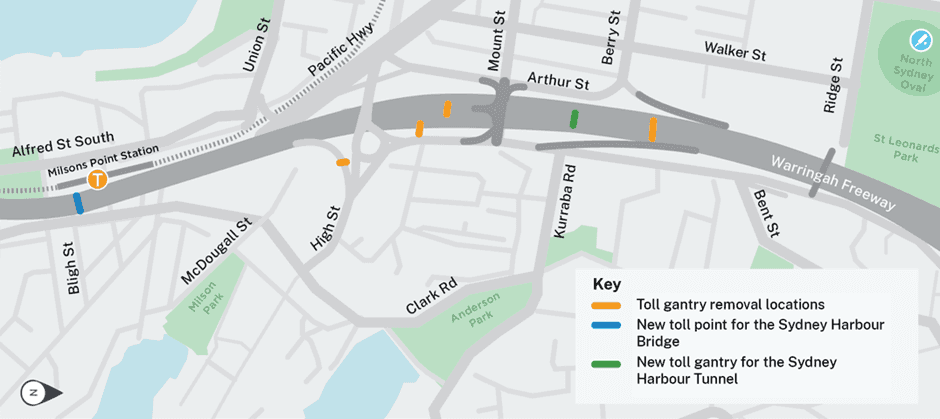
Why did I hear two beeps while crossing Sydney Harbour Bridge or Sydney Harbour Tunnel?
“Beep testing” began on Monday 5 June at the future new toll points for the Sydney Harbour Bridge and Sydney Harbour Tunnel, to calibrate the tolling technology.
Motorists will hear one beep when they are tolled, and another beep for this testing. They will not be tolled twice. Signage has been installed at various locations on the approach to the new toll points to advise motorists to ignore the second beep. This will cease once the relocated toll point becomes operational at midnight on Tuesday, 1 August.
When will the toll points change?
For motorists travelling southbound on the Sydney Harbour Bridge, the new toll point will begin from midnight on Tuesday 1 August.
For motorists travelling southbound in the Sydney Harbour Tunnel, the toll location is expected to change around December 2023.
Will this involve changes to toll costs?
There is no change to the current tolling price or southbound-only toll regime in place for Sydney Harbour Bridge or Sydney Harbour Tunnel. Time of day tolling for southbound journeys will continue at the advertised rates.
I heard a beep while travelling north on the Sydney Harbour Bridge. Have I been tolled?
As some lanes on the Sydney Harbour Bridge operate as both southbound and northbound lanes, there is a low chance some northbound motorists may hear a beep however motorists will not be tolled.
Where can I find more information on this work?
The Warringah Freeway Upgrade includes modifying, upgrading, relocating and installing operational infrastructure such as signage, lighting, tolling, closed circuit television (CCTV), and other traffic management / intelligent transport systems (ITS).
To support the Environmental Impact Statement (EIS) and provide an overview of the principles and practices that apply to the management of utilities and operational infrastructure during construction of the project, the EIS includes a Utilities Management Strategy (Appendix D). This includes a list of major utilities located within or adjacent to the construction footprint that have the potential to be affected by construction of the project and outlines the approach to managing utility adjustments and mitigation measures.
Prior to commencing any proposed works (including activities which fall both within and outside the definition of 'construction'), an environmental risk assessment is required to identify the environmental management measures necessary to meet the environmental outcomes identified in the EIS. Both the EIS and appendices (including Appendix D - Utilities Management Strategy), as well as the Minister's Conditions of Approval for the Project are publicly available. Any additional planning approvals required to ensure consistency with the planning approval for the Project are technical assessments which may contain protected information that is not publicly available.
Where public access to specific technical information is a requirement. Project approval documents including the Construction Environmental Management Plan and relevant sub-plans or appendices, monitoring reports and the Project Environmental Protection Licence is uploaded to the Project portal (Warringah Freeway Upgrade | Transport for NSW | Community Analytics (caportal.com.au))
Which sections in the EIS are specific on tree and vegetation removal?
The EIS has been prepared in accordance with the provisions of Part 5.2 of the Environmental Planning and Assessment Act 1979. Key environmental issues have been considered throughout the design and development process. The following sections of the EIS provide information on tree and vegetation removal:
Chapter 19 – Biodiversity
Chapter 22 – Visual amenity
Appendix S – Biodiversity Development Assessment Report
Appendix V – Urban design, landscape character and visual impact
Appendix W - Arboricultural impact assessment
What are the potential impacts to vegetation?
Most of the sites we will use for our construction have either already been disturbed or contain trees and plantings which have been planted by people (ie. they are not remnant). Transport for NSW will not be removing any remnant native trees and we will re-establish trees and plantings as appropriate.
We will need to remove vegetation, including native plants, planted medians, non-native species and weeds, across around seven hectares of the project’s whole alignment. Most of the trees and plants we need to remove are located within the Warringah Freeway corridor and at the Cammeray Golf Course construction site. We have done our best to minimise vegetation removal and we will continue to minimise the number of trees requiring removal.
What will the project do to mitigate impacts to vegetation and trees?
We will be returning the sites we temporarily use for construction as new areas for you to enjoy. We will work with councils, communities and stakeholders to ensure the best possible use of this space once we have finished our work, and will be seeking your valuable input to help design these legacy projects.
There will be a Place, Design and Landscape Plan carried out as main work activities. As per E178 in the Minister’s Conditions of Approval, the Place, Design and Landscape Plan must be prepared by a suitably qualified and experienced person in consultation with relevant councils, the community and affected landowners and businesses.
We are committed to replacing trees and plantings at a ratio of 2:1 and to delivering an increase in tree canopy in consultation with councils. Tree replacement will be guided by condition E185 of the Minister’s Conditions of Approval (CoA). Among other conditions, replacement trees must be located on public land and prioritised within 500 meters of the affected areas, with the aim of delivering increased shading to footpaths, and pedestrian and cycle paths.
The public display of the Place, Design and Landscape Plan will occur during main work activities.
What is the definition of a tree from the EIS?
Trees were defined and assessed in the EIS as those being at least four metres high with a diameter at breast height (DBH) of over 600 millimetres.
*Note: DBH is a standard measurement for trees and is where the diameter of the trunk is measured. It sits at 4.5 feet / 1.4m high
What is the definition of a tree from the Minister’s Conditions of Approval (CoA)?
As part of the Infrastructure Approval (SSI-8863), the following definition of a tree was provided:
"Long lived woody perennial plant greater than (or usually greater than) 3 metres in height with one or relatively few main stems or trunks (AS4373-2007 Pruning of amenity trees)."
In accordance with Condition of Approval A3, as there is an inconsistency between the EIS definition of a tree and the Infrastructure Approval definition of a tree, the definition of a tree provided in the Infrastructure Approval has been adopted by the Project.
Why is the change in definition of a tree important?
The change in definition has come about from the Ministers Conditions of Approval (CoA). This means the amount of vegetation to be cleared is the same, however, how we define vegetation has changed. What may have been assessed as a shrub or bush in the EIS is now considered a tree under the CoA definition. The benefit of this re-definition is that under CoA E184 (which requires 2:1 replanting of any tree to be removed) more trees will be replanted at the end of the project.
Why is vegetation removal required?
Our work includes underground services removal and relocation which is a construction method requiring trenching, digging and excavation. This work will mean that vegetation roots are impacted by earth working equipment, and can sometimes mean that trees are damaged and unlikely to survive the construction process. In addition to this, tree roots are often wrapped around underground services and utilities. Work to remove roots will sometimes lead to a destabilised tree, which creates a safety risk for nearby communities and road users. This is one of the main reasons why we are removing vegetation which is assessed to be potentially impacted by our construction work.
We are working to minimise our impacts to the environment by ensuring only impacted vegetation including trees are removed from work areas. We are installing tree protection zones around native trees which are located a sufficient distance from our work areas such as excavations.
We may need to remove further vegetation as part of main works. Further information on this will be available once the main work contractor has been engaged. Please contact us for more information or refer to the Environmental Impact Statement.
In what areas will you be clearing vegetation and removing trees?
Where are the area of vegetation including tress which are being removed?
Rosalind Street east – temporary construction site, Cammeray
Cammeray Avenue (along the Warringah Freeway corridor noise walls), Cammeray
Cammeray Golf Course – temporary construction site and work area, Cammeray
Arthur Street east, near Warringah Freeway corridor and Sydney Harbour Tunnel portal, North Sydney
Arthur Street near Pacific Highway, North Sydney
Within the Warringah Freeway corridor (northbound)
Within Anzac Park (south-eastern portion) near Ernest Street and Cammeray Avenue, Cammeray
Anzac Avenue Reserve, Cammeray – along the Warringah Freeway corridor noise wall (accessed from Cammeray Avenue).
We will need to remove further vegetation as part of main works.
Further information on this will be available before main construction starts in 2022. Please contact us for more information or refer to the Environmental Impact Statement.
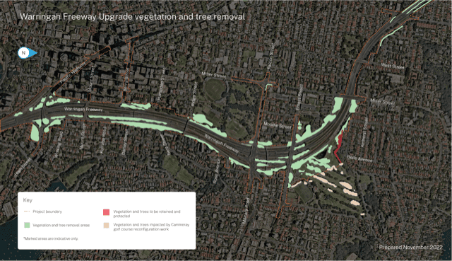
Where are the areas where tree protection zones are being installed?
• Rosalind Street east – temporary construction site compound, Cammeray
• Anzac Park, Cammeray – potable water, electrical construction, communications and ITS construction work area
• Cammeray Avenue, Cammeray – electrical cable removal, communications and ITS construction work area
• Anzac Avenue Reserve, Cammeray – sewer and ITS construction work area
• Cammeray Golf Course – communications, sewer, potable water, and electrical install and removal work areas
• Arthur Street reserve, North Sydney – access track construction and temporary work area.
Fencing will be installed to separate protected native trees from construction work activities.
How has the vegetation removal process been developed?
We have engaged the services of both an independent and qualified arborist and ecologist to review the EIS and early work construction and planning documents to determine the range of individual trees which are either:
• Likely potentially impacted by the early work
• Or not impacted by the early work.
As a result of both the arborist and ecologist’s assessments, we will install a number of tree protection zones, demarcation of removal zones and undertake other mitigation measures to reduce impacts to wildlife and surrounding environment during the vegetation removal process. We will follow Transport for NSW guidelines to undertake this work and meet all statutory requirements for safety and working near traffic.
Will these trees be replaced?
Transport for NSW will work with the community and stakeholders to determine what the future sites will look like as part of the development and public display of the Project’s Place, Design and Landscape Plan. This will include options for replanting a range of vegetation, including native Australian tree species.
We are committed to replacing trees and plantings at a ratio of 2:1 and to delivering an increase in tree canopy in consultation with North Sydney Council. Tree replacement will be further guided by condition E185 of the Minister’s Conditions of Approval. Among other conditions, replacement trees must be located on public land and prioritised within 500 meters of the affected areas, with the aim of delivering increased shading to footpaths, and pedestrian and cycle paths. The public display of the Place, Design and Landscape Plan will occur during main work activities.
How will you remove vegetation safely?
To minimise our impact to road users and construction workers, vegetation which is nearest to live traffic will be removed during the night with temporary lane closures and temporary parking removal controls in place. We use a controlled felling process which includes progressively removing of large branches and trunk sections.
Tree trimming of any overhanging branches over the road corridor or local road at our sites will occur from time to time. No tree trimming will occur on private property, only branches which hang over the road, shared path or footpath.
What is being done with the vegetation once removed?
Native vegetation including trees will be mulched, with mulch to be reused on site where possible and excess mulch will be transported offsite to an appropriately licenced waste facility.
If vegetation is not a native species, it will be mulched separately and taken offsite to a waste facility.
What are the vegetation removal impacts to nearby residents/businesses?
During night work / out-of-hours work
Due to the close proximity of vegetation and trees to live traffic on the Warringah Freeway and other roads, shared paths and footpaths, this work may be required to be done at night to maintain safety for road users and construction workers.
Traffic control and temporary lane closures will be in place to ensure the safety of all road users. You may notice an increase in noise while we carry out this work.
There will be some noise associated with this work and every effort will be made to minimise impacts, including by using low-tonal reversing beepers on machinery during night work, using noise blankets, turning off equipment and vehicles when not in use, and directing noisy equipment away from residences where possible.
For more information on this work including why we need to work at night, please see our three-month look ahead notification and noise fact sheet on our portal at nswroads.work/wfuportal.
During day work / standard construction hours work
There will be some noise associated with this work and every effort will be made to minimise impacts. We will take a one-hour break following a three-hour block of any highly intrusive noise such as using a chainsaw or mulcher during our construction work.
Trees in Cammeray Park
Transport has identified a number of trees within Cammeray Park that have died. All of these trees will be replaced by Transport.
We are currently investigating the circumstances leading to the current issues with the first round of planting, which will inform our replacement plan.
We expect to start replanting in October and will keep the community informed.
Is water that ran off the Cammeray construction site on 06 October contaminated?
No. Water testing to date has confirmed there is no contamination, and poses no threat to the public and no material harm to the environment.
The project team remains in regular communication with the NSW Environment Protection Authority about the current and forecasted rainfall events.
How is water management regulated during construction?
Construction to build the Warringah Freeway Upgrade is carried out under an Environment Protection Licence (EPL), issued by the NSW Environment Protection Authority (EPA) which include measures to control water pollution.
During construction, the Project team will be monitoring water around the sites to ensure our methods are allowing us to meet the terms of our EPL and inform us if we need to make changes.
How will you manage the potential for water erosion and runoff during construction?
The health and safety of our workers, the public and the environment is our priority and we are committed to building the Warringah Freeway Upgrade in a way that effectively manages the potential for erosion and runoff.
Our work is also carried out in line with the environmental management measures specified in our Construction Environmental Management Plan (CEMP), overseen by the Department of Planning and Environment, the EPA and an independent Environmental Representative.
The CEMP has been reviewed and approved by the Department of Planning and Environment and the independent Environmental Representative, prior to the commencement of construction activities on-site.
Construction activities for this project typically involves excavation and earthmoving, which can temporarily expose soil to natural weather events including wind and rain.
Our contractors use a comprehensive suite of erosion and sediment management and mitigation measures at all work sites to manage the potential for exposed soil to be carried offsite.
Erosion and sediment measures are implemented in accordance with the principles and requirements outlined in Managing Urban Stormwater – Soils and Construction, Volume 1 and Managing Urban Stormwater: Volume 2D Main Road Construction, commonly referred to as the ‘Blue Book’, and relevant Transport for NSW guidelines, procedures and specifications. Management of erosion and sediment for major construction projects in accordance with the ‘Blue Book’ is well known, tried and proven.
A soil conservation specialist has been engaged by both Transport for NSW and the Contractor for the duration of construction to provide advice regarding erosion and sediment control measures including review of Erosion and Sediment Control Plans.
What do erosion and runoff controls do?
Erosion and sediment controls aim to prevent or reduce soil erosion, trap and retain sediment and isolate and treat water before it enters the drainage system and surrounding waterways.
What are some key erosion and runoff controls used during construction?
A variety of measures are used to manage soil erosion and runoff during construction.
|
Name |
Description |
Purpose |
|
Geofabric covers |
A textile product placed over a soil surface. |
Protects soil from being carried in the water and wind. |
|
Soil binder |
Green tackifying agent often found on sloped or hard-to access soil surfaces. |
Reduces erosion by binding topsoil. |
|
Cover crop vegetation |
Vegetation, such as grasses, which grow and die off rapidly. |
The root structure holds the soil together while permanent vegetation grows. |
|
Sediment fencing |
A textile material trenched into the ground and positioned vertically like a fence. |
Traps sediment and reduces runoff velocity while still enabling water to flow through. |
|
Sediment basins |
Man-made ponds. |
Collects and stores sediment-laden water for treatment before discharge. |
|
Surface drains |
A channel used to divert water. |
Redirects to minimise sediment runoff from site. |
How do you manage water during wet weather events?
All temporary sites are prepared for wet weather events and have considered additional measures as result of higher than average falls experienced during 2022.
Before weather events we:
inspect erosion and sediment controls to confirm compliance with industry best practice
confirm drainage is clear of obstructions
remove items which may create obstructions
reduce the water level of sediment basins to create holding capacity.
During wet weather events we:
monitor conditions closely
have our emergency management response team available 24 hours, with access to contractors, machinery and equipment.
What are you doing differently given these abnormal rain events are becoming more frequent?
We are installing additional controls as follows:
Additional clean water diversions at various locations around the temporary site perimeter to prevent clean water entering the site area
Installation of additional bunds across the general site area to hold water and / or slow down any flows
Additional containment area are being utilised within the middle of the site to hold water
Use of additional pumps to allow more efficient movement of water between existing sediment ponds.
Do you monitor run off?
The project team carry out a water quality monitoring program to assess the impacts of the upgrade on surface water quality during construction. Each sampling location has a specific threshold that cannot be exceeded. Should any of the site-specific trigger values be exceeded, a management response will be triggered.
Why does the water look muddy?
Water that travels through an exposed site such as a temporary construction site can pick up exposed soil. The water looks ‘muddy’ and is designed to be treated before leaving site in typical rainfall events.
During rain fall events that are more intense than a typical event, it is possible for waterflows to exceed the required capacity of the site. In these events it is not always feasible to control water and untreated ‘muddy’ runoff is accepted, provided the project has complied with the requirements of its environmental approvals and licences.
Where does excess water go when it leaves the Cammeray temporary construction site?
The excess water enters the existing stormwater network which is connected to Middle Harbour. This stormwater network also services the wider catchment and is approved for use by the project in this manner.
Do you work with the Environment Protection Authority and Department of Planning and Environment?
Yes. Our work is overseen by, and the project team is in regular communication with, the Environment Protection Authority (EPA) and Department of Planning and Environment (DPE). In situations such as a rain fall event that is more intense the Warringah Freeway Upgrade project team is in regular contact with regulatory bodies.
Previous FAQs
What is the temporary shared user path?
In early January 2022, Transport for NSW will be starting work on a new temporary shared user path within the Cammeray golf course as part of the Warringah Freeway Upgrade. The temporary shared user path will be built for use by both cyclists and pedestrians.
The main section of the temporary shared user path will run between Warringa Road and Ernest Street. The temporary shared user path will be around 400 metres long and three metres wide to allow cyclists and pedestrians to safely share the path. It has been designed to ensure safety and improve access for pedestrians and cyclists.
The path will be built to meet relevant design standards and will have rest areas near steeper sections. As an additional safety precaution, specialised fencing will be installed in sections near the golf course to separate golfers and play from path users.
A temporary footpath about 80 metres long will be built on the eastern side of Warringa Road along the golf course boundary. This will connect pedestrians from the end of the temporary shared user path at Warringa Road to the existing Cammeray Road footpath. The detailed design for this section footpath is still being finalised in consultation with North Sydney Council.
How long will it take to build the temporary shared user path?
Transport for NSW expect it will take about three months to complete the temporary shared user path, weather permitting.
Why is a temporary shared user path being built?
We are building the temporary shared user path to enable cyclists and pedestrians to continue to move through the golf course during construction.
In accordance with the Ministers Conditions of Approval, Transport for NSW must relocate the existing shared user path which runs through the Cammeray golf course, before it can start building a main construction site within the golf course.
How long will the temporary shared user path be in place?
The temporary shared user path will be in place until construction of the Warringah Freeway Upgrade, Western Harbour Tunnel and Beaches Link (pending approval) projects are completed.
The final configuration of the temporary shared user path will be developed when all construction activities at the site have been finished.
When will work take place?
Work will take place during the day from 7am to 6pm Monday to Friday and from 8am to 6pm on Saturdays. Noting the above are the COVID-19 construction hours of 8am to 6pm on Saturdays. These hours are approved until the end of March 2022. We will keep the community informed of any changes as they come to hand.
Who will be building the temporary shared user path?
Sydney Program Alliance (SPA) will be building the temporary shared user path. The alliance consists of Transport for NSW, John Holland, Jacobs and Freyssinet. SPA will also continue to deliver service and utility relocation works for the Warringah Freeway Upgrade and undertake work to reconfigure the Cammeray golf course as part of the project's conditions of approval.
Related changes
Will the Cammeray golf course be changing?
Yes. Transport for NSW is using a portion of the Cammeray golf course, next to the Warringah Freeway, during construction and for some permanent operational facilities for the Western Harbour Tunnel and Beaches Link (pending approval) project's.
Transport has been working closely with the Cammeray Golf Club to design a reconfigured nine hole golf course.
What will the changes to the Cammeray golf course involve?
Transport for NSW is continuing to consult with the Cammeray Golf Club Directors and General Manager to finalise the design to deliver a reconfigured nine-hole course.
A stormwater storage dam located within the Cammeray golf course will also be relocated as it will be directly impacted by widening of the Warringah Freeway.
Will Transport for NSW be replacing the existing stormwater storage dam?
Yes, the existing stormwater dam located in the Cammeray golf course will be permanently replaced within the boundaries of the golf course to maintain ongoing functionality of the North Sydney Stormwater Re-use Scheme.
The existing storage dam will be removed when the construction site at the Cammeray golf course is built in 2022.
Where does the water that is currently collected in the Cammeray golf course dam come from?
A local gross pollutant trap and pump station at Warringa Road, on the northern side of the Cammeray golf course, collects local stormwater run-off which is then pumped to the stormwater storage dam for re-use by North Sydney Council and the Cammeray Golf Club.
Changes to access
Will there be changes to cyclist and pedestrian access during construction?
Pedestrian and cyclist access through the Cammeray golf course will be maintained during the construction of the temporary shared user path.
Pedestrian and cyclist access may be temporarily changed for short periods along Ernest Street to allow work to be carried out safely, however you will be notified in advance of any changes to access. Any temporary changes will be signposted and stakeholders notified as appropriate.
Will the existing shared user paths and footpaths through the golf course be impacted during construction of the temporary shared user path?
No, there will be no change to the existing shared user paths and footpaths through the golf course until Transport for NSW have finished building the new temporary shared user path in late March 2022.
Will the Cammeray golf course, skate park, soccer field and tennis courts remain open during construction of the temporary shared user path?
Yes, the golf course will continue to operate with an interim course configuration while the temporary shared user path is built. Public recreation and open space facilities including the Cammeray Oval, tennis courts and skate park will remain open for the community during construction of the Warringah Freeway Upgrade and will not be impacted.
After the new temporary shared user path is completed, the golf course will be temporarily closed for about nine months, with the reconfigured golf course re-opening late December 2022. The golf course closure and works are being coordinated with the Cammeray Golf Club.
How can I learn more about the reconfiguration of the golf course and what it will look like?
Work on the golf course reconfigured design is still being finalised.
Transport for NSW will be providing the community with further detail on what the reconfiguration of the golf course will look like in early 2022. Transport will have a number resources available then including digital images and animations, as well as opportunities to speak to the team and the Cammeray Golf Club about the reconfiguration work via virtual or in person community information sessions.
Does the new temporary shared user path replace the cyclist path that enters Cammeray Park from the Warringah Freeway?
Yes, the temporary shared user path will enable cyclists to continue to move through Cammeray Park.
How has Transport for NSW obtained feedback on the temporary shared user path?
Transport for NSW is continuing to consult with bicycle user groups in the development of shared user paths in and around Cammeray golf course. Transport for NSW has also engaged with North Sydney Council on the design and construction of the temporary shared user path.
If you have any suggestions on how the amenity of the temporary shared user path can be improved, you can complete this online survey.
Construction Impacts
How will the project team access the Cammeray construction areas?
To minimise impacts to the Cammeray golf course fairways during construction of the temporary shared user path, the project team will be working from the current temporary Cammeray early works construction site and will continue to access the site via Ernest Street.
Will the work impact parking?
For the safety of cyclists and pedestrians, Transport for NSW is proposing to temporarily remove four restricted on-street parking spaces on Warringa Road during construction of the temporary shared user path. This is to facilitate construction of a ramp and enable path users to have safe lines of sight to other cyclists, motorists and pedestrians.
Transport will be consulting with directly adjacent residents on the removal of these spaces. If approved, the parking spaces will be removed in early 2022 until Transport has finished using the Cammeray golf course temporary construction site for the Warringah Freeway Upgrade, Western Harbour Tunnel and Beaches Link (pending approval) projects.
There may also be some intermittent impacts to parking along Warringa Road during the work, however these will be returned to the community outside of work hours.
How can the community contact the project team in relation to this work?
If you have any questions or would like to speak to a member of the Transport for NSW team, please get in touch with them directly on 1800 931 189 or whtbl@transport.nsw.gov.au and ask to speak to the Warringah Freeway Upgrade project team.
Environmental impacts
Will trees be removed to build the temporary shared user path?
Yes, Transport for NSW will need to clear some vegetation and remove or trim some trees to build the temporary shared user path.
Transport has designed the temporary shared user path to minimise the number of trees required for removal and will continue to refine the design, wherever possible, to further reduce their impact.
Why can't the temporary shared user path be built in a way that impacts less trees?
The temporary shared user path has been designed to minimise impacts, but some trees will need to be removed to meet relevant design standards, ensure safety, improve access for users and to minimise impacts on the golf course reconfiguration. To make the best use of the existing landscape, reconfigured golf course greens are proposed to run up to the edge of the temporary shared user path.
Options to include the path within the construction site footprint were investigated but these conflicted with a retaining wall, an access road and the general topography of the area. The path has been designed as close to the construction site boundary as possible.
Transport for NSW has worked hard to minimise the number of trees that need to be removed and will continue to refine the design, where possible, to further reduce impacts.
Why weren't these trees assessed during the environmental impact statement period?
The Western Harbour Tunnel and Warringah Freeway Upgrade Environmental Impact Statement (EIS) described the proposed approach to construction of the project. The Ministers Conditions of approval included the requirement to build both a temporary shared user path as well as carry out work to reconfigure the golf course. The exact extent of these changes were not known during the EISs development, however, it was always acknowledged the reconfiguration work would require some changes to the existing landscape of the golf course.
Under what environmental approvals are these trees being removed?
The construction of the temporary shared user path is being carried out under what is called “Low Impact Works” in accordance with the project's Minister's Conditions of Approval and as part of the overall Cammeray golf course readjustment work. This assessment has included further detailed ecological and arborist investigations and has been approved by the Independent Environmental Representative, who is appointed by the Department of Planning, Industry and Environment.
What is being done to ensure vegetation removal is not impacting local wildlife?
The project's management plans include steps to safely capture and relocate any fauna in partnership with expert ecologists. You can read more about this process in the Biodiversity Development Assessment Report completed as part of the Western Harbour Tunnel and Warringah Freeway Upgrade Environmental Impact Statement.
Will trees be replanted?
Yes, Transport for NSW are committed to replacing trees and plantings at a ratio of 2:1 and delivering an increase in tree canopy in consultation with North Sydney Council.
Transport is also exploring different opportunities to replant trees and vegetation progressively during construction. Transport will work in collaboration with Council and the community to identify opportunities to use a variety of sizes and maturity of plantings.
How will the project determine if land is contaminated in the golf course?
Any unsealed ground (i.e. ground that is not under concrete, asphalt or other sealed surface) in areas which were identified in the Western Harbour Tunnel and Warringah Freeway Upgrade Environmental Impact Statement as posing a moderate to high risk of exposing contaminated soil during construction, will undergo a Detailed Site Investigation (DSI) by a certified Contaminated Land Consultant before the ground is disturbed.
The investigations will provide further information about the extent and level of contamination in the area and recommend if further investigations or remediation are required. The DSI’s are intended to enable the project team to appropriately plan for and manage contaminated material.
Detailed site investigation reports for the Cammeray golf course will be made available on this interactive portal in the future.
What is the process for handling contaminated material?
If contaminated soil is found, it will be classified based on the level of contamination and the physical and chemical properties of the soil.
The material will then be managed to make sure no contaminated materials are carried off-site, and workers and the community are adequately protected.
All identified contamination risk areas will be managed during construction using a comprehensive suite of environmental management measures outlined in the contractor's Construction Environmental Management Plan and in accordance with guidelines made or approved under section 105 of the Contaminated Land Management Act 1997.
If contaminated material is removed from the site, it will be transported in sealed and covered trucks and disposed of at an appropriately licensed waste facility in accordance with the NSW EPA Waste Classification Guidelines.
Why are you progressing with the Beaches Link components of the Warringah Freeway Upgrade?
The NSW Government is committed to progressing the development of Beaches Link and Transport for NSW is continuing with planning approvals for the project. Project determination for Beaches Link is expected in the coming months.
The Western Harbour Tunnel and Warringah Freeway Upgrade projects were approved in January 2021 by the Minister for Planning and Public Spaces and will be constructed and operated in accordance with the Minister's Conditions of Approval. As part of future proofing our infrastructure and reducing overall impacts to the community, interface with Beaches Link is being considered as part of the Warringah Freeway Upgrade design and construction methodology development. The Warringah Freeway Upgrade scope of work includes the establishment of the required infrastructure to link into the future Beaches Link, including tunnel portals.
What is a detailed design?
Typically for complex major infrastructure projects progressing through an environmental planning and assessment process, the design and construction approach presented in the Environmental Impact Statement (EIS) is at planning stage and indicative only.
The design presented in the EIS is subject to refinement once the contractor delivering the project has been appointed and have carried out further investigations, engineering analyses and construction planning activities such as refining methodologies. The current design will then be further developed to define project elements in greater detail and ensure integration of adjoining infrastructure.
The detailed design phase will take approximately 12 to 18 months to complete and will be progressively incorporated into the planning and delivery of construction work.
Will the contractor make changes in the detailed design?
The Western Harbour Tunnel and Warringah Freeway Upgrade project was approved in January 2021 by the Minister for Planning and Public Spaces. The project will be constructed and operated in accordance with the Ministers Conditions of Approval (CoA).
The design and construction of the Warringah Freeway Upgrade was awarded to CPB Contractors and Downer EDI Works in a joint venture in September 2021.
If a change to the project is proposed, which is not consistent with the planning approval, an application will be made to the Minister to modify the CoA. A modification would be sought in accordance with the requirements of Division 5.2 of the Environmental Planning and Assessment Act 1979. A planning modification to the CoA would require further community consultation.
A copy of the CoA can be found on the Department of Planning, Industry and Environment’s (DPIE) website and our interactive portal.
Will we be consulted if there are any changes?
If a change to the project is proposed, which is not consistent with the planning approval, an application will be made to the Minister to modify the CoA. A modification would be sought in accordance with the requirements of Division 5.2 of the Environmental Planning and Assessment Act 1979. A planning modification to the CoA would require further community consultation.
There will be future opportunities to provide input to the Warringah Freeway Upgrade project. We will be returning the sites we temporarily use for construction as new areas for you to enjoy. We will work with councils, communities and stakeholders to ensure the best possible use of this space once we have finished our work, and will be seeking your valuable input to help design these legacy projects.
There will be a Place, Design and Landscape Plan (PDLP) carried out as part of main work activities. As per E178 in the CoA, the PDLP must be prepared by a suitably qualified and experienced team, in consultation with relevant councils, the community and affected landowners and businesses.
When will we see the detailed design?
The design and construction of the Warringah Freeway Upgrade was awarded to CPB Contractors and Downer EDI Works in a joint venture in September 2021.
Following the contract award, the detailed design phase will take around 12 to 18 months to complete.
Our Videos and images page on our interactive portal contains helpful visual information.
We will keep you up to date with project milestones via updates and notifications in your letterbox and email. Please subscribe to our email updates at our interactive portal or by getting in touch with the team.
What are the Warringah Freeway Upgrade early works?
The Warringah Freeway Upgrade early works started in March 2021 and includes a program of around 12 months of activities to remove and relocate a range of critical underground and above-ground services and utilities before main construction starts.
The design and construction of the Warringah Freeway Upgrade has been awarded to CPB Contractors and Downer EDI Works in a joint venture. Please read our Community Update - September 2021 for more information.
Where can I learn more about early work activities?
To learn more about our work, please refer to the following documents for more information including maps:
January 2021 Community Update – Planning approval to start work
March 2021 Community Update – services and utilities work starts soon
March 2021 Ridge Street temporary construction site fact sheet
May 2021 North Sydney early work update including Blue Street temporary construction site
All documents are available at Transport for NSW’s website nswroads.work/wfuportal.
Community and stakeholders are encouraged to stay updated with the latest information about our work. On the project website you can see weekly updates under the ‘upcoming work’ menu tab. You can also subscribe to email alerts about the work by contacting the project team, completing the online ‘contact us’ form on the website or phoning the team.
Phone: 1800 931 189
Email: whtbl@transport.nsw.gov.au
Website: nswroads.work/wfuportal
Post: Customer feedback, Transport for NSW, Locked Bag 928 North Sydney NSW 2059.
Who is Sydney Program Alliance?
Sydney Program Alliance (SPA) is delivering selected projects across Sydney on behalf of NSW Government consisting of Transport for NSW, John Holland, Jacobs and Freyssinet.
Where can I see what work is upcoming near me?
For the latest work updates, please visit our ‘Upcoming work’ portal, which is updated regularly. To access this portal, please click here.
When will early work be happening near me?
Work at Alfred Street North, Neutral Bay and Ridge Street north, North Sydney started in March 2021.
Work at Arthur Street/Mount Street, North Sydney and both Cammeray Golf Course and Cammeray Avenue sites, Cammeray commenced in late May 2021.
Work in Anzac Park, Cammeray (west) will commence in early July 2021.
When is early work planned to be finished?
Sydney Program Alliance is due to finish the service and utilities relocation and removal work in early 2022.
What will the site be used for?
Transport for NSW is proposing to modify the approved Western Harbour Tunnel and Warringah Freeway Upgrade project (the project) to include an additional construction support site at 160 Wicks Road, Macquarie Park. The proposed construction support site would use the existing and established Porters Creek Environmental Construction Materials Recycling Facility. It would be used as a material storage and stockpiling location, a car parking employee transfer area for construction personnel, and a precast concrete facility to support construction of the Warringah Freeway Upgrade.
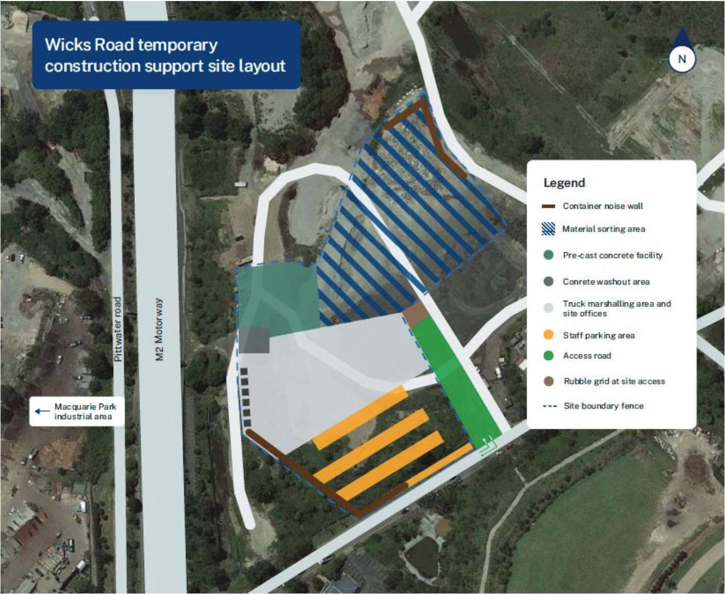
If the proposal is approved, when will work start and how long will the site be used for?
The proposed modification is currently on display and is available to view on the Department of Planning and Environment (DPE) website. Once the public exhibition period has closed, DPE will provide Transport with a copy of all the submissions made. We will then prepare a submissions report to respond to the issues raised. The report will be submitted to DPE and it will be available to view on their website. This report will help inform the Minister for Planning's decision on the modification.
If the modification is approved, we will start establishing the site soon after this. We will keep you informed at every stage of the process. If approved, the site is planned to be used by the project until 2027. To stay up to date with the process, please email us at whtbl@transport.nsw.gov.au and ask to be added to the email distribution list.
How will this change the existing use of the site?
The existing Porters Creek Environmental Construction Materials Recycling Facility is currently a construction waste management facility. The Western Harbour Tunnel and Warringah Freeway Upgrade modification would only need minimal site establishment and would not substantially change how the land is used.
What will the impacts of the proposed site be?
We do not expect there to be new impacts as a result of our use of the site and we are planning to implement a number of new and/or improved mitigation measures to manage:
air quality impacts
soil and water impacts
biodiversity impacts
noise impact
lighting and visual amenity impacts
traffic impacts
For more information on these impacts and how we will be managing them, please see the Wicks Road Construction Support Site - Modification report.
How has Transport consulted with the community on this proposal?
In early September 2022, we engaged with the Macquarie Park community and sought feedback on our proposal. We considered this feedback as part of the modification to the project's planning approval. This modification report is now available on the Department of Planning and Environment's (DPE) website. You are invited to have your say during the exhibition period from Wednesday 9 November 2022 until Tuesday 22 November 2022 and we encourage you to make a submission during this time.
What was the outcome from the recent community consultation?
During the two-week consultation in September 2022, we received feedback from 16 individuals and one organisation. The key issues they raised included:
light spill
traffic volume during operation
noise from site operations
air quality (specifically dust)
soil and water quality
contamination and waste
visual impacts
construction duration
These concerns were taken into consideration in the development of the modification and will be used to reduce our impacts throughout construction.
What is Transport doing in response to community feedback?
In response to community feedback, we will implement a range of mitigation methods to reduce impacts from our work at the site. These include, but are not limited to:
putting up temporary noise barriers
carrying out noise monitoring to help us monitor our noise levels to determine the effectiveness of our mitigation measures and modify our work where possible
implementing dust control measures (see our FAQ answer on this page on minimising potential impacts on air quality)
managing traffic to reduce impacts to traffic flow and maintain safety for the community.
For other relevant controls being used across the project, please see the Warringah Freeway Upgrade construction management plans, available here.
How can I have my say and find out more?
The proposed modification is currently on display and is available to view on the NSW Planning Portal. You are invited to have your say during the exhibition period from Wednesday 9 November 2022 until Tuesday 22 November 2022.
To read the November 2022 Community Update, please click here. Click here to read the Modification 1 Wicks Road Construction Support Site report.
To make a submission:
Visit DPE's Major Projects website at planningportal.nsw.gov.au/major-projects
Create a user account by clicking 'My Account' at the top right of the homepage then follow the steps to create an account.
When you are logged in, click on 'Make a submission'; then select 'Western Harbour Tunnel & Warringah Freeway Upgrade-Mod-1'.
A live online information session will be held on Wednesday 16 November from 6pm to 7.30pm. Join the webinar to meet the project team, hear about the proposal and ask questions.
To register to attend, please call 1800 931 189 or email whtbl@transport.nsw.gov.au with the subject line 'Wicks Road information session'. We will then send you the details for joining the session.
How can I make a complaint if I am impacted by work at the site?
To make an inquiry or a complaint about the project, you can call our community information line, 1800 931 189, which is available 24 hours a day and is attended during the project operation hours. Inquiries and complaints may also be received by the project email at whtbl@transport.nsw.gov.au, and by post:
Customer feedback Transport for NSW
Locked Bag 928
North Sydney NSW 2059