Consultation
See our community and stakeholder engagement activities to date.
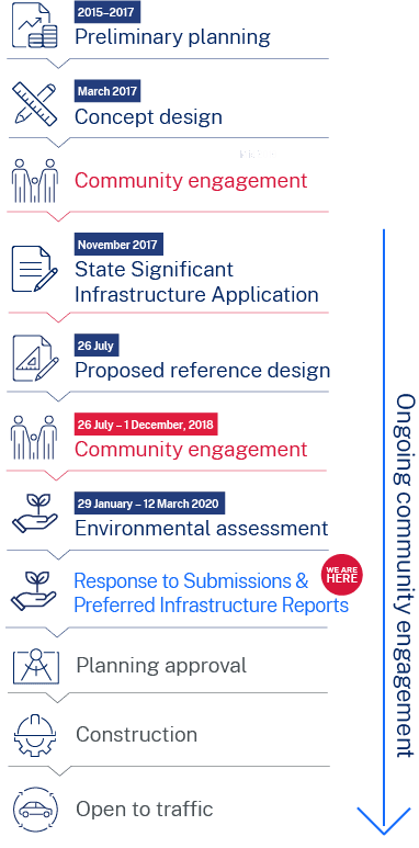
Engagement to date What you told us Design changes Managing community concerns What happens nextEngagement to date
We recognise a project of this scale will have an unavoidable impact on local communities. This is why we have completed one of the most extensive engagement programs for a motorway project.
Since the release of the preferred route and concept design in 2017, we have engaged with thousands of you who live and work in and around our project area. We have listened to better understand your concerns and have incorporated your feedback and suggestions into our design where possible.
Our commitment to you is we will continue to actively engage with you to hear your feedback on this city-shaping project.
Our engagement program for Beaches Link and the Gore Hill Freeway Connection included companion project the Western Harbour Tunnel and Warringah Freeway Upgrade. We prepared a separate environmental impact statement (EIS) for Western Harbour Tunnel and Warringah Freeway Upgrade, which assessed any temporary and permanent impacts. This EIS was placed on public exhibition from 29 January to 30 March 2020.
In 2018, we carried out a wide range of consultation and engagement activities to help refine our design based on community feedback and we worked to reduce community impact where possible.
Most recently, the Beaches Link and Gore Hill Freeway Connection Environmental Impact Statement (EIS) was on public exhibition between 9 December 2020 and 1 March 2021. During this time, we carried out a range of consultation activities to engage with you on the EIS, encourage feedback and support the submissions process. We would like to thank you for meeting our team, engaging with us and providing your valuable feedback.
We have now prepared a submissions report, which responds to the 1549 submissions received from the community, NSW Government agencies and local councils during the EIS exhibition period. In addition, we have also prepared a separate preferred infrastructure report to provide further information, to describe design changes and assessments in response to a request from the Department of Planning, Industry and Environment (DPIE). These reports are available on this site via the buttons below as well as on the DPIE Major Projects website.
What you told us
2018 Proposed Reference design
Your feedback on the Western Harbour Tunnel and Beaches Link Proposed Reference design 2018
focused on the following topics:
2020 Environmental Impact Statement exhibition
Each submission has been examined individually to understand the concerns raised. Where similar issues have been raised in different submissions, only one response has been provided.
Key environmental issues raised:
Key issues raised in community submissions:
Each submission on the EIS has been examined individually to understand the concerns raised. Where similar issues have been raised in different submissions, only one response has been provided. Issues raised related to:
- environment
- project development and alternatives
- strategic context and project need
- stakeholder and engagement
- project description
- assessment process
- construction work.
The key environmental issues raised are broken down in the following chart. For more information on issues raised, please refer to Section A of the submissions report.
Note - 78% of community submissions received related to environmental issues, and a breakdown of these is shown in the above chart.
*Other issues included
- Land use and property
- Urban design and visual amenity
- Out of scope
- Greenhouse gas and climate change
- Heritage
- Operational noise and vibration
- Sustainability
- Resource use and waste management
- Cumulative impacts
- Flooding
- Hazards and risks
- Related projects
We have listened to your feedback and we have made changes
We thank you for your feedback. It has helped us make a number of positive improvements to the project. These include:
Changes prior to the EIS exhibition
We carried out extensive consultation during 2017 for the concept design and 2018 for the proposed reference design. During this time your feedback was critical in helping us refine the design and make a number of positive changes to the project, a number of which were presented in the EIS. These changes included:
Improving access to Beaches Link and the new and improved open space and recreation facilities at Balgowlah
We have worked with the community on a number of alternatives to connect Beaches Link with Sydney Road, provide access for users of the new and improved public open space and recreation facilities at Balgowlah, and deliver a solution that provides the best outcome for the community. As a result, we have redesigned the permanent access road to reduce its length, area, and impacts.
Maximising usable community space in the final layout at Balgowlah
We have redesigned the connection at Balgowlah to return an area equivalent to around 90 per cent of the current open space at Balgowlah to the community as new and improved open space and recreation facilities. The redesign allows for earlier completion and handover of some new open space areas. The final layout will be determined based on community input as part of a dedicated consultation process to be jointly led by Transport for NSW and Northern Beaches Council. Further details of this will be released to the community later this year.
Reducing impacts on Burnt Bridge Creek, Balgowlah
The proposed tunnel portal location at Burnt Bridge Creek Deviation has been shifted further to the south. This enables us to reduce traffic staging works on Burnt Bridge Creek Deviation, reduce our impacts on Burnt Bridge Creek and eliminate the need to demolish and replace the existing Kitchener Street Bridge.
Maximising distance between construction activities and community facilities at Willoughby and Northbridge
Using the eastern side of Flat Rock Drive as a temporary construction support site provides a greater distance between the site and the Willoughby Leisure Centre indoor facilities, netball courts and car park, and avoids direct impacts to the baseball diamond. Construction vehicles will have direct access to and from the site via Flat Rock Drive. At completion, the site will be rehabilitated in line with the land use zoning. Vegetation and landscaping will be determined in consultation with Willoughby City Council and the community.
Moving the tunnel connection to the Wakehurst Parkway further north to reduce impacts to the surrounding community
The tunnel entry and exit ramps have been moved about 450 metres further north along Wakehurst Parkway. This will reduce construction and operational impacts for the surrounding community as well providing an improved tunnel connection to Wakehurst Parkway. This significant design change was adopted following community engagement on the concept design in 2017.
Reducing impacts of the Wakehurst Parkway construction support site, near Kirkwood Street, on the surrounding community
Using the Sydney Water land north of Kirkwood Street as a temporary construction support site minimises impacts to residents and Seaforth Oval. After construction, the section of this site not required for Sydney Water operations will be incorporated into the Manly Warringah War Memorial State Park for the community to enjoy.
Changes since the EIS exhibition
Your feedback received during the EIS exhibition has been used to further refine the project design and update environmental management measures. Further design refinements outlined in the submissions report include but are not limited to:
Developing a plan to work with the community on how we manage our impacts on Flat Rock Reserve and rehabilitate the site with local input
We understand the importance of the Flat Rock area to the local community and we are committed to rehabilitating the site once our project is completed.
We are committed to working with Willoughby Council and the local community on measures to minimise our impacts, enhance the social and environmental value of Flat Rock Reserve, and quickly and responsibly rehabilitate the site. Transport for NSW will consult with Willoughby City Council and the community, (including bush care groups) to determine the vegetation and landscaping which will be used for rehabilitation, eg selection of plant species, the final alignment of walking tracks and measures which could be taken ahead of construction commencing.
Within one year of commencement of construction at the Flat Rock Drive construction support site, Transport will develop a Flat Rock Drive Social Value Strategy. The strategy will be developed in consultation with Willoughby City Council and relevant community groups and include initiatives which enhance the social and environmental value of the Flat Rock Reserve. These initiatives, which will be implemented during construction and for three years post the completion of construction, will seek to:
- enhance the Flat Rock Reserve, including in the areas of access, amenity and facilities
- support existing Council and community outcomes, initiatives and programs
- partner with educational facilities and other stakeholders in research.
Reducing impacts to Spit West Reserve, Mosman
Following further consultation with Mosman Council and recreational user groups, we have reconfigured the Spit West Reserve temporary construction support site. The reconfiguration will reduce impacts to recreational users of the reserve during construction by maintaining access to the majority of current facilities, such as playing fields for soccer, netball, cricket, running and school sport.
Improving pedestrian and cyclist connectivity across Wakehurst Parkway, Frenchs Forest
We have refined the Wakehurst Parkway shared user bridge ramps at Frenchs Forest, following further consultation with NSW Department of Education (School Infrastructure) and Northern Beaches Council. The refined design will provide direct pedestrian and cyclist connectivity between Fitzpatrick Avenue East and Aquatic Drive, as well as facilitate direct access to the Warringah Aquatic Centre and proposed new Forest High School, east of Wakehurst Parkway. The refined design will reduce the area of Duffys Forest endangered ecological community impacted by the project and avoid permanent impacts to the Jumping Jack mountain bike trail. Please see our fact sheet on the refined design available on our interactive portal.
Reducing impacts to the local mountain bike trail network
We understand the importance of the mountain bike trails around Wakehurst Parkway to the local community. We are committed to further refining the design of Wakehurst Parkway to avoid or minimise impacts to the local mountain bike trail network where possible, in consultation with Northern Beaches Council and key bike user groups.
Managing community concerns
We know building a project of this scale and significance does not go without impact.
We will have a community contact system in place during construction and will ensure there is a number of ways you can contact us and raise concerns or make enquiries at any time.
We will also be working closely with teams from nearby construction projects to help minimise construction and consultation fatigue in your local area.
What happens next
The NSW Government remains committed to Beaches Link. Following independent advice, the NSW Government is restaging major infrastructure projects such as Beaches Link so they can be delivered in a sustainable and affordable way for taxpayers.
The Beaches Link project is still yet to receive Planning approval. We have now provided the submissions report and preferred infrastructure report to DPE to help inform the Minister for Planning and Public Spaces when making a decision on approval of the project.
We expect to have a decision on the project in mid 2022. If the project is approved, it will be built and operated in line with conditions of approval set by the Minister for Planning and Public Spaces.
The contractor/s, once appointed and subject to project approval, will also be required to develop detailed environmental management plans to minimise and manage construction impacts. These plans will cover noise and vibration, air quality, traffic and access among others.
We will work with the appointed contractor/s to provide you with regular updates about our planned activities. At this stage we will also be able to provide you with more information on timing of key activities, details of traffic changes and how impacts will be managed.
We are committed to continuing to work collaboratively with our stakeholders and the community throughout the project.
Please note: the program timing shown in the Beaches Link EIS was indicative at the time of the Planning for the project.
Welcome to the Beaches Link and Gore Hill Freeway Connection portal
This dedicated interactive portal contains the latest information, maps and videos about the Beaches Link and Gore Hill Freeway Connection project.
If you are looking for information about the Warringah Freeway Upgrade or Western Harbour Tunnel, please visit the dedicated project portals:
Warringah Freeway Upgrade portal Western Harbour Tunnel portal
If you have any complaints or enquiries, please contact us.
Welcome to the Beaches Link and Gore Hill Freeway Connection EIS map
Explore our interactive map to see the project alignment and key information about the proposed design and construction of the project.
Please note: This interactive map contains information from the Beaches Link and Gore Hill Freeway Connection Environmental Impact Statement (EIS) which was published in December 2020. Since then, our project design and planning has continued to progress, including the release of the Submissions and Preferred Infrastructure Reports in November 2021.
For the latest project information, please visit the documents section of our portal or contact our team.
Make a submission
To make a submission on the Beaches Link and Gore Hill Freeway Connection Environmental Impact Statement, use the online form. All submissions received will be placed on the DPIE website.
The public consultation and submission period closes on 11.59pm, Monday 1 March 2021.
For a video tutorial on how to make a submission on the DPIE website click here.
To watch a video tutorial about how you can subscribe to receive timely, project-related alerts click here.
If you want DPIE to delete your personal information before publication, please make this clear at the top of your letter.
At-property noise treatment
We understand noise can be a source of disruption to local communities during the construction and operation of major road projects. To minimise the impact of our project on local residents, we are delivering at-property noise treatment to eligible properties. Noise treatment refers to architectural acoustic measures which aim to improve the sound resistance of properties, such as window and door upgrades.
We have developed a Noise Insulation Program which outlines the criteria and process for delivering noise treatment to affected properties as part of the project.
Providing at-property treatment is a complex process and involves a number of different steps. To learn more, see our fact sheet.
We are starting the process of delivering noise treatment before the project is approved so residents benefit from reduced noise as early as possible.


RSVP for a virtual information session
RSVP for a virtual information session
Virtual information sessions
We are committed to continuing to work with you and to adapting to the changing circumstances around COVID-19.
Reservations for the February 2021 sessions have now closed. You can watch the recorded sessions online by clicking on the button below.
Western Harbour Tunnel and Warringah Freeway upgrade Tender Hub - Contact us
We are happy to coordinate virtual tutorials to explain the tools and techniques of the model as required.
Please raise a question in the RFT Data Room should you require any additional support.
Contact the Beaches Link team
What is an EIS?
The EIS assesses the potential environmental and social impacts of the Western Harbour Tunnel and Warringah Freeway Upgrade during construction and operation. The EIS also includes strategies to avoid, mitigate and manage the potential impacts of the project.
In the EIS, we cover topics such as traffic and transport, air quality, noise and vibration, construction and biodiversity impacts.
The NSW Department of Planning, Industry and Environment (DPIE) placed the EIS on exhibition from 29 January to 30 March 2020. This closing date was extended from 12 March following feedback from the community. During this time everyone had the opportunity to make submissions on the project. We are now working on a submissions report to respond to the issues raised. This report will be made public. All submissions made to DPIE are available on their website.
Make a submission
Have your say on Western Harbour Tunnel and Warringah Freeway Upgrade
How to make an online submission:
- Visit DPIE’s Major Projects website at planningportal.nsw.gov.au/major-projects
- Create a user account by clicking the ‘Sign In’ icon in the top right of the homepage or under the ‘Services’ tab and then click the ‘Have Your Say’ link
- When you are logged in, find the Western Harbour Tunnel and Warringah Freeway Upgrade project, and click the ‘Make a Submission’ icon.
How to make a hard copy submission:
You can submit a hard copy of your submission. If you want DPIE to delete your personal information before publication, please make this clear at the top of your letter. You need to include:
- your name and address, at the top of the letter only
- the name of the application and application number: SSI_8863
- a statement on whether you support or object to the proposal
- the reasons why you support or object to the proposal
- a declaration of any reportable political donations made in the previous two years.
You can hand deliver your submission to DPIE’s office, located at:
4 Parramatta Square, 12 Darcy Street
Parramatta NSW 2150
You can post your submission to:
Attention: Director, Transport Assessments
Planning & Assessment, Department of Planning
Industry and Environment
Locked Bag 5022
Parramatta NSW 2124
Submissions must be received by DPIE before midnight 30 March 2020.
Filter the EIS
Select the topics you are interested in reading about
Related chapters
Select from topics of interest above

Indicative construction program

Indicative construction program

Indicative construction program

Indicative construction program

Indicative construction program

Indicative construction program

Indicative construction program

Indicative construction program

Indicative construction program

Indicative construction program

Indicative construction program

Indicative construction program

Indicative construction program

Indicative construction program
Virtual information sessions


Privacy statement
Transport for NSW (“we”) are collecting your personal information in connection with public consultation on the Western Harbour Tunnel, Warringah Freeway Upgrade and Beaches Link projects (“the Program”). We will retain and use this information for consultation purposes, including communications and analysis in connection with the Program.
We may share your submission or complaint with another NSW government agency where relevant having regard to the nature of the submission or complaint. Otherwise, except for anonymous information which does not identify you, we will not publish or disclose your personal information to any third parties without your consent unless authorised by law.
Providing your personal information is voluntary but if you do not provide it we may not include you on our stakeholder database and you might miss further consultation opportunities.
Your personal information will be held and managed by Transport for NSW in accordance with the Privacy and Personal Information Protection Act 1998 and you can contact us to access or correct it. Please email us at whtbl@transport.nsw.gov.au, write to us at Transport for NSW, Locked Bag 928, North Sydney NSW 2059, or call us on 1800 931 189.
Website accessibility
This statement relates to content available on the Transport for NSW Beaches Link and Gore Hill Freeway Connection portal (https://caportal.com.au/rms/bl).
This website has been developed with the aim to be available to the widest possible audience, including those using assistive technology or accessibility features.
Ongoing monitoring and development is part of our strategy and we strive to comply with W3C's Web Content Accessibility Guidelines.
At times, we publish documents and publications received from third parties. These third party documents may not adhere to the standards followed by Transport for NSW.
If you have any questions or comments about this statement or have problems accessing information or functions on this site please contact us.
Adobe PDF
This site contains information in portable document format (PDF). These files are made available so information is easy to download and is portable.
Some documents on this website may not conform with WCAG 2.0. If you encounter any problems accessing documents in PDF format please contact us.
Acknowledgement of country
Transport for NSW acknowledges the traditional owners and custodians of the land, and respects Elders past and present.
Welcome to the Beaches Link and Gore Hill Freeway Connection portal
This dedicated interactive portal contains the latest information, maps and videos about the Beaches Link and Gore Hill Freeway Connection project.
If you are looking for information about the Warringah Freeway Upgrade or Western Harbour Tunnel, please visit the dedicated project portals:
Warringah Freeway Upgrade portal Western Harbour Tunnel portal
If you have any complaints or enquiries, please contact us.
Welcome to the Beaches Link and Gore Hill Freeway Connection EIS map
Explore our interactive map to see the project alignment and key information about the proposed design and construction of the project.
Please note: This interactive map contains information from the Beaches Link and Gore Hill Freeway Connection Environmental Impact Statement (EIS) which was published in December 2020. Since then, our project design and planning has continued to progress, including the release of the Submissions and Preferred Infrastructure Reports in November 2021.
For the latest project information, please visit the documents section of our portal or contact our team.
Make a submission
To make a submission on the Beaches Link and Gore Hill Freeway Connection Environmental Impact Statement, use the online form. All submissions received will be placed on the DPIE website.
The public consultation and submission period closes on 11.59pm, Monday 1 March 2021.
For a video tutorial on how to make a submission on the DPIE website click here.
To watch a video tutorial about how you can subscribe to receive timely, project-related alerts click here.
If you want DPIE to delete your personal information before publication, please make this clear at the top of your letter.
At-property noise treatment
We understand noise can be a source of disruption to local communities during the construction and operation of major road projects. To minimise the impact of our project on local residents, we are delivering at-property noise treatment to eligible properties. Noise treatment refers to architectural acoustic measures which aim to improve the sound resistance of properties, such as window and door upgrades.
We have developed a Noise Insulation Program which outlines the criteria and process for delivering noise treatment to affected properties as part of the project.
Providing at-property treatment is a complex process and involves a number of different steps. To learn more, see our fact sheet.
We are starting the process of delivering noise treatment before the project is approved so residents benefit from reduced noise as early as possible.
RSVP for a virtual information session
RSVP for a virtual information session
Virtual information sessions
We are committed to continuing to work with you and to adapting to the changing circumstances around COVID-19.
Reservations for the February 2021 sessions have now closed. You can watch the recorded sessions online by clicking on the button below.
Western Harbour Tunnel and Warringah Freeway upgrade Tender Hub - Contact us
We are happy to coordinate virtual tutorials to explain the tools and techniques of the model as required.
Please raise a question in the RFT Data Room should you require any additional support.
Contact the Beaches Link team
What is an EIS?
The EIS assesses the potential environmental and social impacts of the Western Harbour Tunnel and Warringah Freeway Upgrade during construction and operation. The EIS also includes strategies to avoid, mitigate and manage the potential impacts of the project.
In the EIS, we cover topics such as traffic and transport, air quality, noise and vibration, construction and biodiversity impacts.
The NSW Department of Planning, Industry and Environment (DPIE) placed the EIS on exhibition from 29 January to 30 March 2020. This closing date was extended from 12 March following feedback from the community. During this time everyone had the opportunity to make submissions on the project. We are now working on a submissions report to respond to the issues raised. This report will be made public. All submissions made to DPIE are available on their website.
Make a submission
Have your say on Western Harbour Tunnel and Warringah Freeway Upgrade
How to make an online submission:
- Visit DPIE’s Major Projects website at planningportal.nsw.gov.au/major-projects
- Create a user account by clicking the ‘Sign In’ icon in the top right of the homepage or under the ‘Services’ tab and then click the ‘Have Your Say’ link
- When you are logged in, find the Western Harbour Tunnel and Warringah Freeway Upgrade project, and click the ‘Make a Submission’ icon.
How to make a hard copy submission:
You can submit a hard copy of your submission. If you want DPIE to delete your personal information before publication, please make this clear at the top of your letter. You need to include:
- your name and address, at the top of the letter only
- the name of the application and application number: SSI_8863
- a statement on whether you support or object to the proposal
- the reasons why you support or object to the proposal
- a declaration of any reportable political donations made in the previous two years.
You can hand deliver your submission to DPIE’s office, located at:
4 Parramatta Square, 12 Darcy Street
Parramatta NSW 2150
You can post your submission to:
Attention: Director, Transport Assessments
Planning & Assessment, Department of Planning
Industry and Environment
Locked Bag 5022
Parramatta NSW 2124
Submissions must be received by DPIE before midnight 30 March 2020.
Filter the EIS
Select the topics you are interested in reading about
Related chapters
Select from topics of interest above
Indicative construction program
Indicative construction program
Indicative construction program
Indicative construction program
Indicative construction program
Indicative construction program
Indicative construction program
Indicative construction program
Indicative construction program
Indicative construction program
Indicative construction program
Indicative construction program
Indicative construction program
Indicative construction program
Virtual information sessions
Privacy statement
Transport for NSW (“we”) are collecting your personal information in connection with public consultation on the Western Harbour Tunnel, Warringah Freeway Upgrade and Beaches Link projects (“the Program”). We will retain and use this information for consultation purposes, including communications and analysis in connection with the Program.
We may share your submission or complaint with another NSW government agency where relevant having regard to the nature of the submission or complaint. Otherwise, except for anonymous information which does not identify you, we will not publish or disclose your personal information to any third parties without your consent unless authorised by law.
Providing your personal information is voluntary but if you do not provide it we may not include you on our stakeholder database and you might miss further consultation opportunities.
Your personal information will be held and managed by Transport for NSW in accordance with the Privacy and Personal Information Protection Act 1998 and you can contact us to access or correct it. Please email us at whtbl@transport.nsw.gov.au, write to us at Transport for NSW, Locked Bag 928, North Sydney NSW 2059, or call us on 1800 931 189.
Website accessibility
This statement relates to content available on the Transport for NSW Beaches Link and Gore Hill Freeway Connection portal (https://caportal.com.au/rms/bl).
This website has been developed with the aim to be available to the widest possible audience, including those using assistive technology or accessibility features.
Ongoing monitoring and development is part of our strategy and we strive to comply with W3C's Web Content Accessibility Guidelines.
At times, we publish documents and publications received from third parties. These third party documents may not adhere to the standards followed by Transport for NSW.
If you have any questions or comments about this statement or have problems accessing information or functions on this site please contact us.
Adobe PDF
This site contains information in portable document format (PDF). These files are made available so information is easy to download and is portable.
Some documents on this website may not conform with WCAG 2.0. If you encounter any problems accessing documents in PDF format please contact us.
Acknowledgement of country
Transport for NSW acknowledges the traditional owners and custodians of the land, and respects Elders past and present.