Drag the slider from the left to right to compare the existing road layout with the design.
Share this: Share on Facebook Tweet on Twitter


Select the topics you are interested in reading about
Select from topics of interest above
Hello and welcome to the Beaches Link and Gore Hill Freeway Connection virtual information room.
This is your opportunity to have your say on the project's Environmental Impact Statement (EIS). Submissions must be made directly to the Department of Planning, Industry and Environment (DPIE) before midnight Monday 1 March 2021.
This room will help you learn more about key aspects of the project. Explore the interactive map, browse the information boards around the room, view videos and images, or read the EIS chapters. Before you leave, make sure you register for one of our live virtual information sessions and sign up for project updates.
We look forward to helping you learn more about the project. Call the team on 1800 931 189 or email us at whtbl@transport.nsw.gov.au for more information.
Select below to watch a replay or sign up for a the next live session.
(Answer)
(Answer)
(Answer)
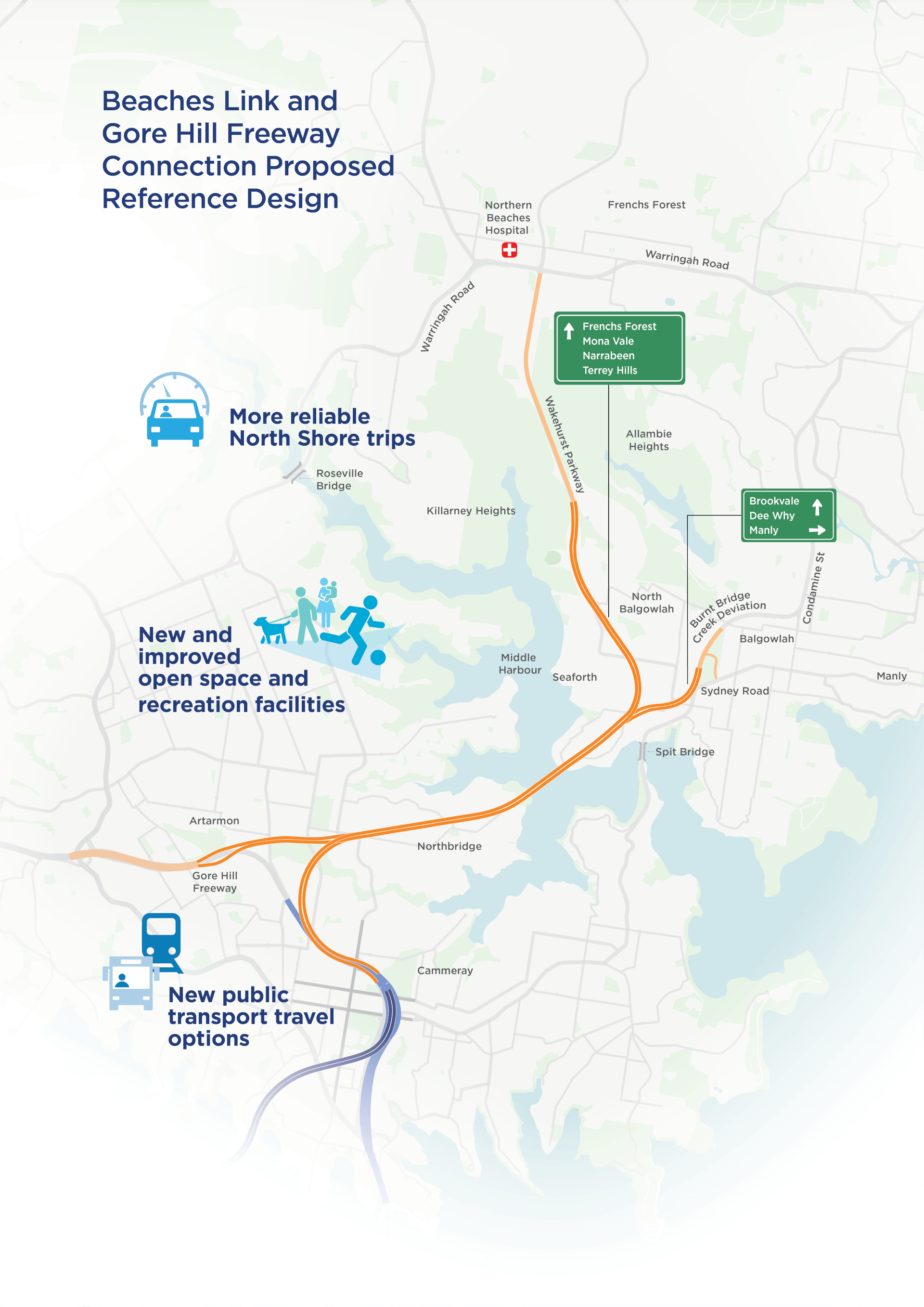
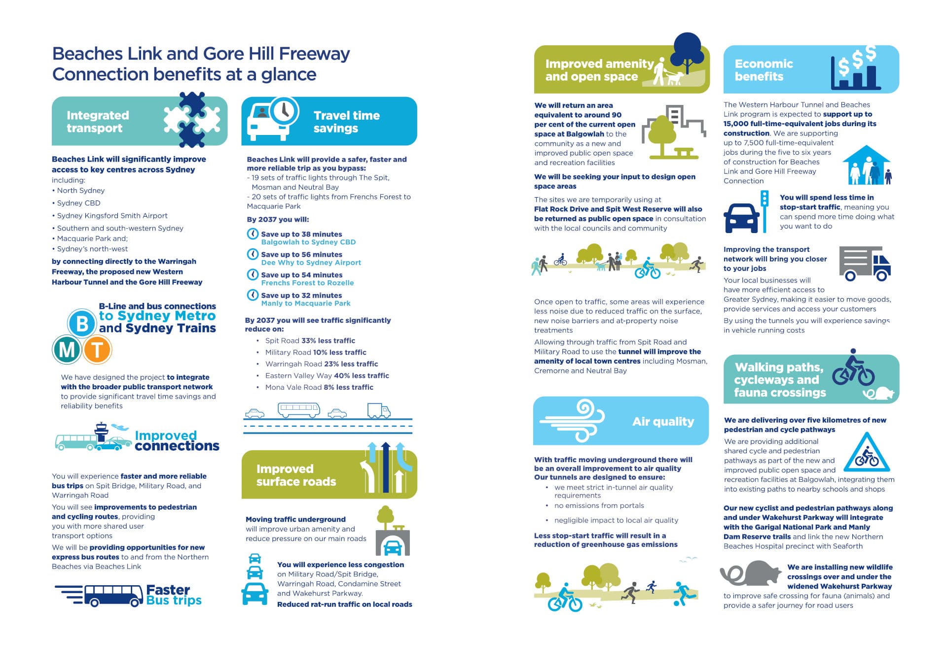
The Beaches Link and Gore Hill Freeway Connection is an important part of our vision to create an integrated road and public transport network, ensuring Sydney is a well-connected and liveable city for generations to come. A city-shaping project, this new motorway will change the way you travel to and from the Northern Beaches.
When completed, this project will reduce travel times, enabling you to get to your destination faster by improving capacity and reliability on critical transport routes on both sides of Middle Harbour.
This project will offer new direct connections from the Northern Beaches to Warringah Freeway and North Sydney, the Inner West (via the Western Harbour Tunnel) and St Leonards and Macquarie Park (via the Gore Hill Freeway Connection), linking people with more jobs, education and services. It will also benefit local businesses by providing more direct and efficient access to and from the Northern Beaches for the movement of goods.

The EIS is now on display and you have the opportunity to review the assessments and provide feedback on our findings. Submissions must be made directly to the Department of Planning, Industry and Environment (DPIE) before midnight Monday 1 March 2021. Once the public exhibition period has closed, DPIE will provide us with a copy of your submissions so we can prepare a submissions report to respond to your feedback.
We thank you for the feedback, which has helped us make a number of positive improvements to the project. They include:
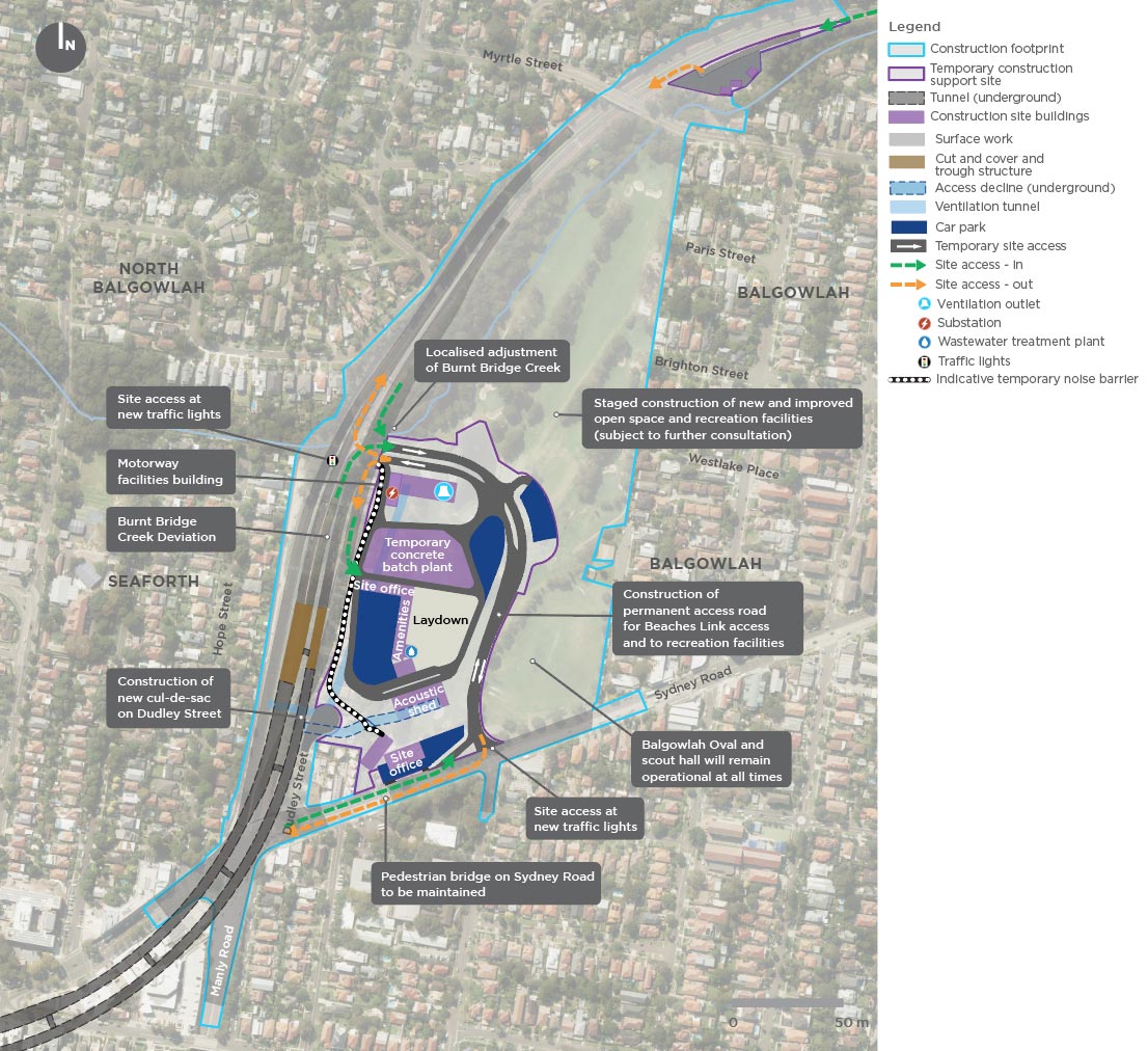
We have worked with the community on a number of alternatives to connect Beaches Link with Sydney Road, provide access for users of the new and improved public open space and recreation facilities at Balgowlah, and deliver a solution that provides the best outcome for the community. As a result, we have redesigned the permanent access road to reduce its length, area and impacts, while still providing access to the new public open space and recreation facilities.
We recognise that maximising the amount of public open space once construction is complete is important to you. We have redesigned the connection at Balgowlah to return an area equivalent to around 90 per cent of the current open space at Balgowlah to the community as a new and improved open space and recreation facilities. The final layout will be determined based on community input as part of a dedicated consultation process. We are working collaboratively with Northern Beaches Council and plan to have more than half of the recreation precinct open for you to use around two years after we start construction, three to four years earlier than we originally planned.
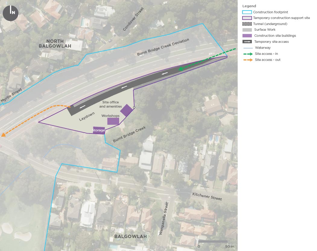
The proposed tunnel portal location at Burnt Bridge Creek Deviation has been shifted further to the south. This enables us to reduce traffic staging works on Burnt Bridge Creek Deviation, reduce our impacts on Burnt Bridge Creek and eliminate the need to replace the existing Kitchener Street Bridge.
The tunnel entry and exit ramps at Killarney Heights have been moved about 450 metres further north along Wakehurst Parkway. This will reduce construction and operational impacts for the surrounding community as well providing an improved tunnel connection to Wakehurst Parkway. This significant design change was adopted following community engagement on the concept design in 2017.
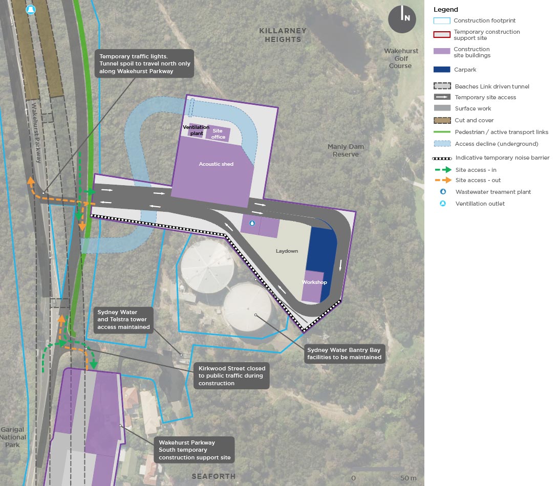
Using the Sydney Water land north of Kirkwood Street as a temporary site minimises impacts to residents and Seaforth Oval. After construction, the section of this site not required for Sydney Water operations will be incorporated into the Manly Dam Reserve for the community to enjoy.
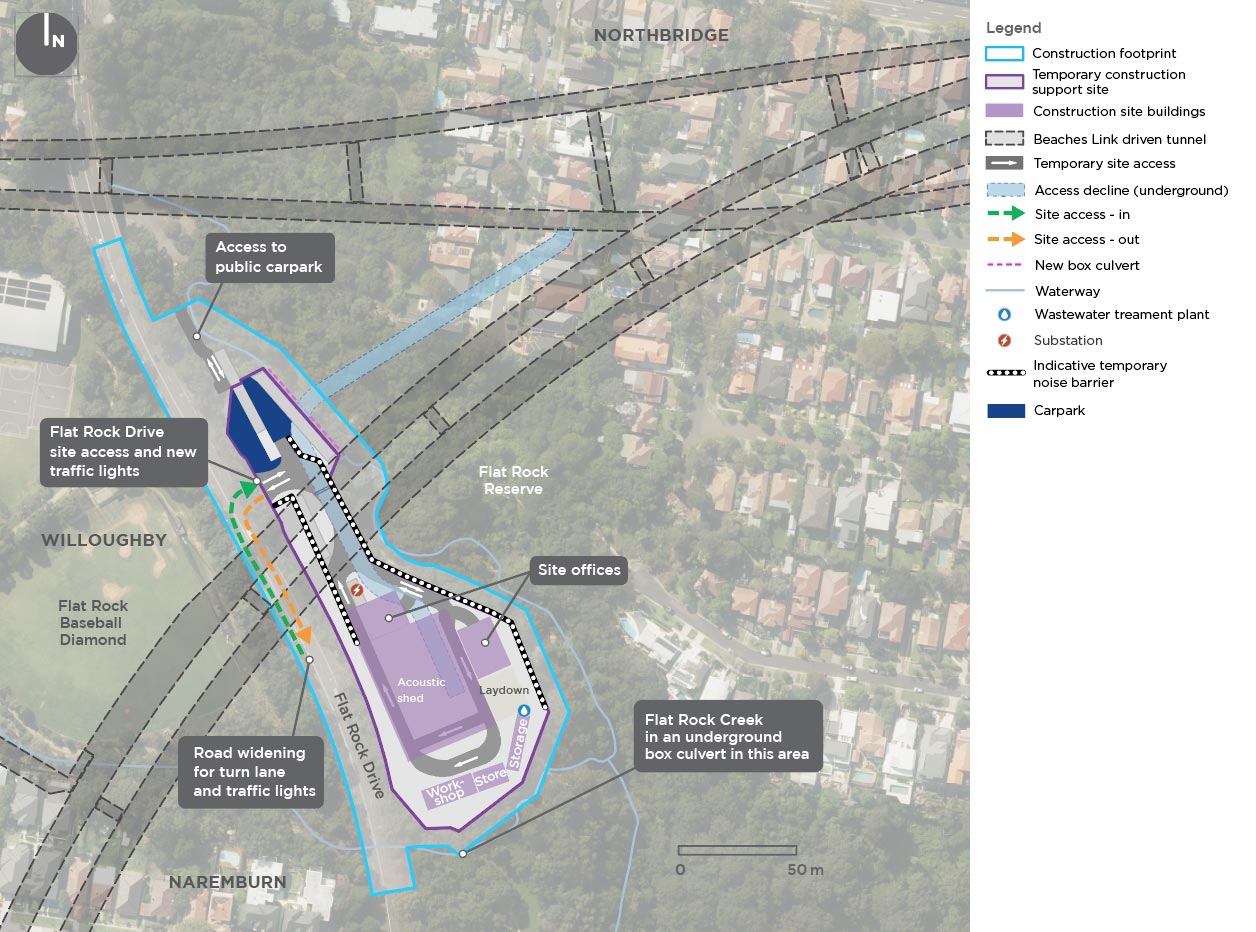
We need a temporary site that provides us with access to the middle section of the project. Using the eastern side of Flat Rock Drive as a temporary site provides a greater distance between the site and the Willoughby Leisure Centre indoor facilities, netball courts and car park, and avoids impacts to the baseball diamond.
The EIS assesses the potential environmental and social impacts of the Beaches Link and the Gore Hill Freeway Connection project.
This section provides an overview of the key environmental impacts during construction and operation of the project, and our mitigation measures to manage these. We have generally used a conservative approach in our assessments with impacts presented based on worst-case scenarios.
As part of the planning process for the project, we have collected and analysed a significant amount of data to understand how people currently use the road network, and carried out a detailed traffic and transport assessment to help us make predictions about future traffic conditions. Our assessments looked at existing road traffic, local roads and parking, public transport, pedestrians and cyclists, and maritime traffic. In addition to the benefits the project will deliver, we also investigated and assessed the potential impact to the local and wider road network and to vessels on the harbour; both while we are building and when we are open to traffic at project completion.
The assessment process included traffic modelling that considers future population growth, land use, and other major road network and public transport projects to understand how the project will integrate with the broader transport network today and into the future.
Traffic and transport fact sheet Download Chapter 8: Construction traffic and transport Download Chapter 9: Operational traffic and transport
Our assessments of potential noise impacts are always conservative and always assess the worst-case scenario. The assessments and noise modelling have assumed our machinery (plant) is working in similar areas at the same time.
Further detailed planning will ensure these situations are minimised through staging of noisy works and implementation of other listed mitigation measures.
Therefore, we often find when we are working, the noise generated is less than predicted.
Noise and vibration fact sheet Download Chapter 10: Construction noise and vibration Download Chapter 11: Operational noise and vibration
We recognise that air quality is important. Our commitment is that the tunnels will be built and operated to meet strict air quality standards using modern ventilation and tunnel design. All ventilation systems will be built and operated to strictly comply with any conditions specified in DPIE’s planning approval, and the EPL to be issued by the EPA.
You may be interested to know the independent NSW Chief Scientist and Engineer has released a report in relation to road tunnel air quality. The report found that using ventilation outlets and avoiding portal emissions are the most effective methods of mitigating the air quality impacts of road tunnels. These methods result in a negligible change to surrounding air quality and as such, there is little to no health benefit for surrounding communities in installing filtration and air treatment systems in such tunnels. For more information on the report visit www.chiefscientist.nsw.gov.au or visit the Air Quality Portal.
Sydney has a rich blend of Aboriginal and Non-Aboriginal cultural heritage. We know there are significant heritage items along the project corridor and are committed to preserving this heritage as a legacy for future generations.
Download Chapter 14: Non-Aboriginal heritage Download Chapter 15: Aboriginal heritage
We understand the character and visual amenity of your local area is important to you. We carried out an urban design, landscape character and visual assessment, which considered the potential for impact to the overall landscape, and visual amenity as a result of our project.
Our project has been designed to make the most of existing transport corridors and built up urban areas. This is so our project can blend into the surrounding environment and reduce the character and visual impact in local areas, where possible.
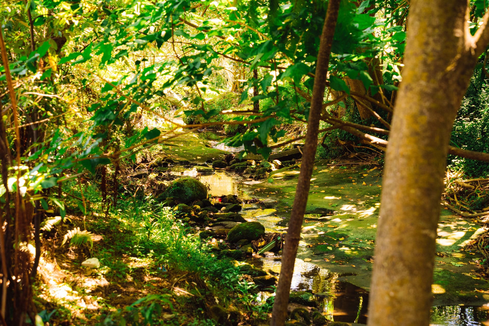
Sydney has a rich biodiversity with a variety of native plants and animals that form thriving ecosystems both on land and in the water. We are committed to protecting the local flora and fauna during construction and operation of this project.
We have carried out extensive biodiversity surveys in the study area and have completed a detailed Biodiversity Development Assessment Report to understand the biodiversity impact of the project. To read the report, please refer to Appendix S in the EIS.
We have carefully selected each of our temporary sites to limit our impact on you while we are working in and to keep your neighbourhoods and streets safe during construction.
To minimise impacts on the community, our temporary sites generally:
Our temporary sites are located at:
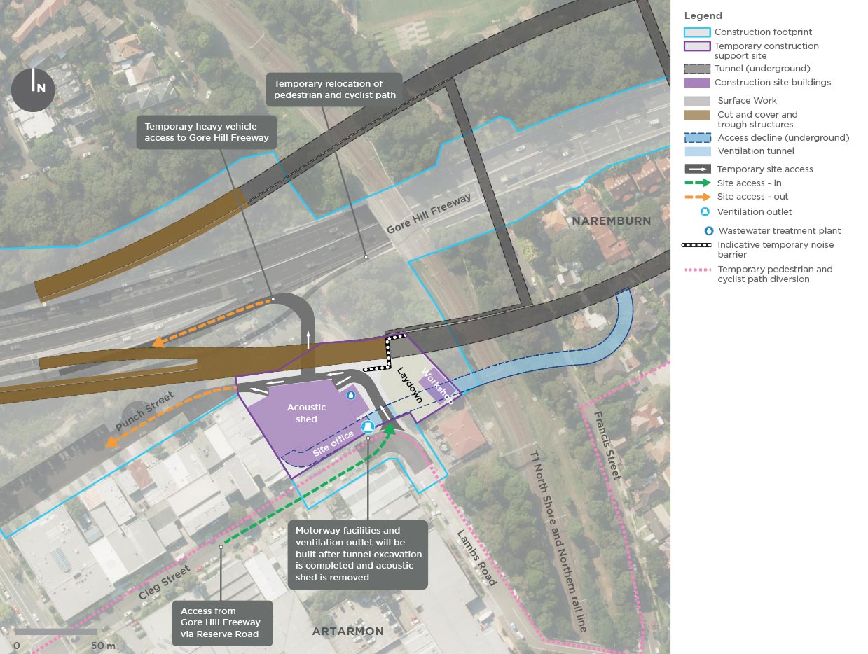
We will be setting up a temporary support site at Punch Street within the Artarmon industrial area. We will use this site to support the excavation and fitout of the tunnels east towards Northbridge, the construction of the Beaches Link cut and cover structures and the permanent motorway facilities for Beaches Link.
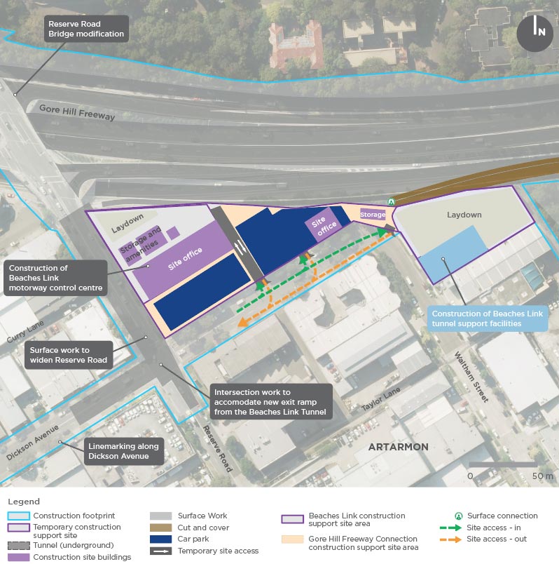
We will be setting up a temporary support site at Dickson Avenue within the Artarmon industrial area to support construction of Beaches Link and the Gore Hill Freeway Connection.
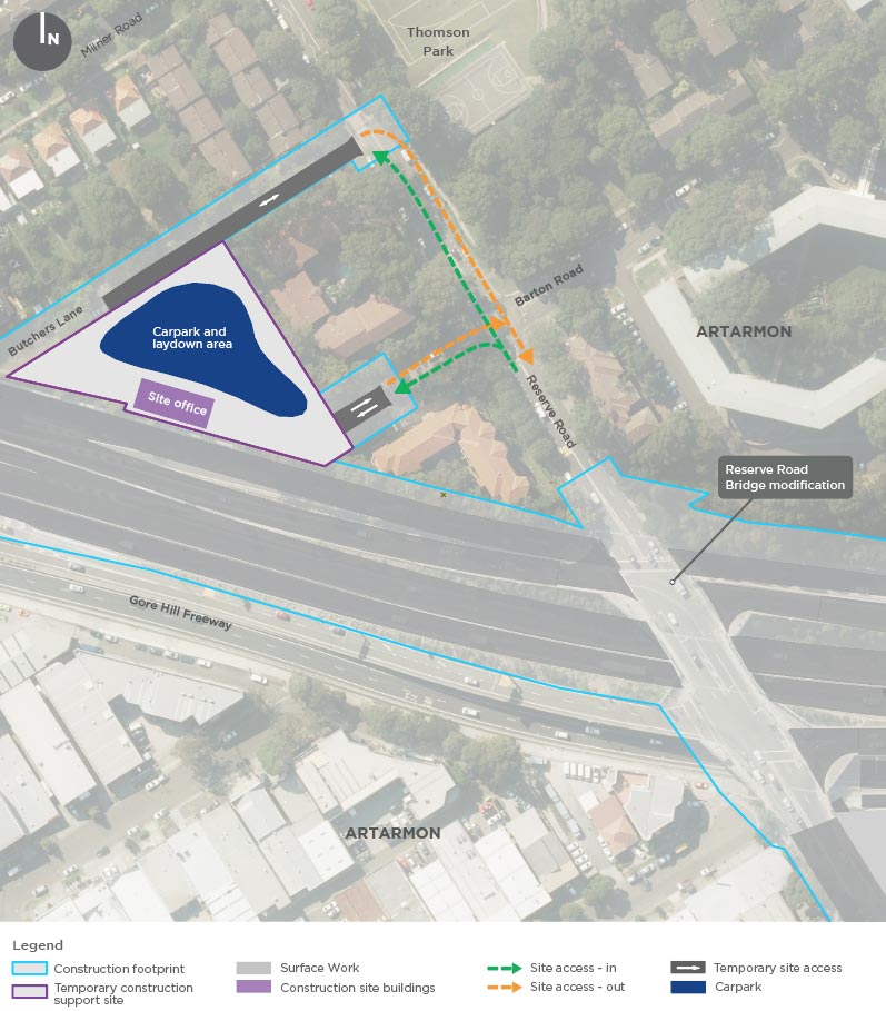
We will be setting up a temporary support site on Barton Road to support construction of the Gore Hill Freeway Connection.
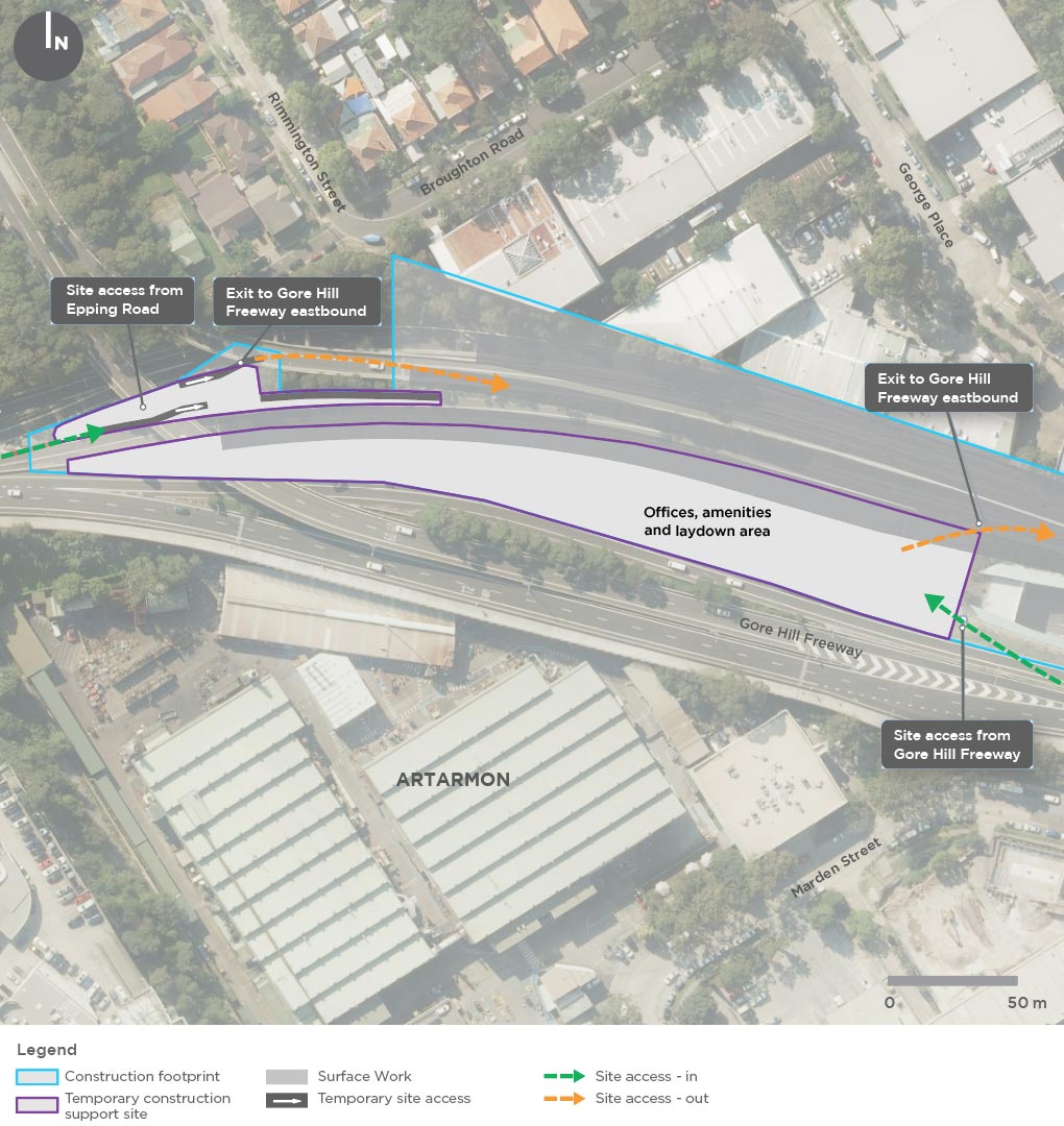
We will be setting up a temporary support site on the median above the Lane Cove Tunnel, within the Gore Hill Freeway to support construction of the Gore Hill Freeway Connection.
We will be setting up a temporary construction site at Balgowlah Golf Course and Dudley Street. This will be a tunnel support site, surface works support site and project management site.
We will be setting up a temporary construction site at Kitchener Street to support construction work along Burnt Bridge Creek Deviation.
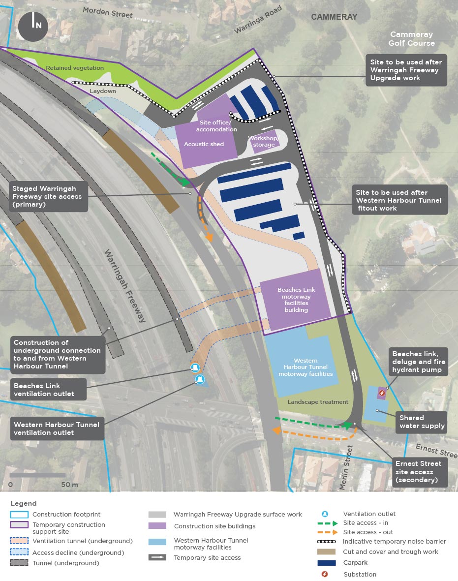
We will be setting up a temporary construction site next to the Warringah Freeway at the
Cammeray Golf Course. The site would initially be established as a temporary site for the Western Harbour Tunnel and Warringah Freeway Upgrade project, and construction and fitout of motorway facilities at Warringah Freeway.
The site will then support construction of the Beaches Link component of the project.
Wakehurst Parkway north
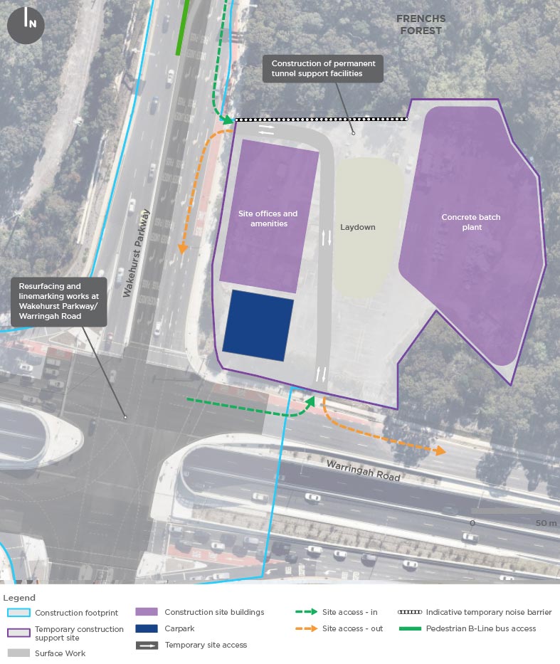
We will be setting up a temporary construction support site on Wakehurst Parkway at Frenchs Forest to support surface road work, intersection work and to build a permanent tunnel support facility. This site was recently used as a construction site for the Northern Beaches Hospital road upgrade.
Any areas that have been rehabilitated and returned to the community from the road upgrade project will not be used for Beaches Link. The rehabilitated area will be fenced off and protected from our work.
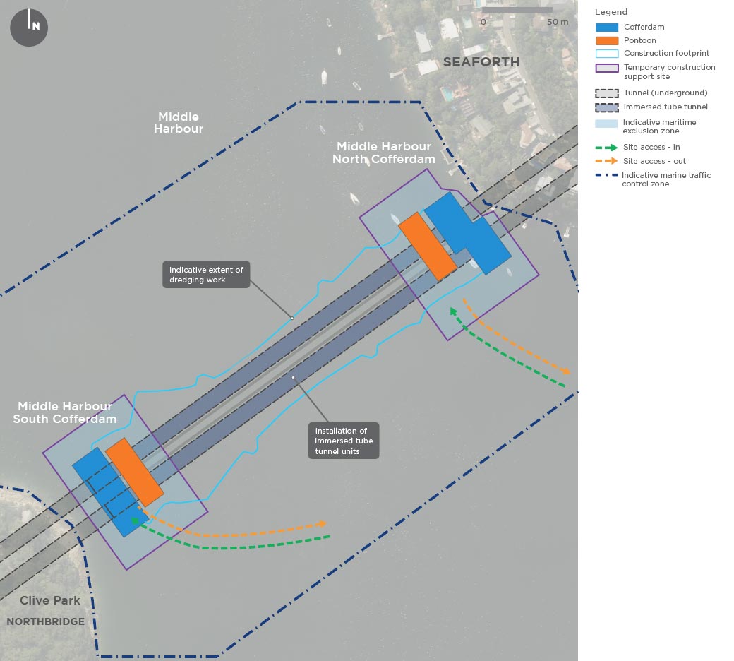
We will be building temporary cofferdams in the harbour to support our tunnelling work. These cofferdams will be temporary and help connect the land tunnels with the immersed tube tunnels, in the harbour.
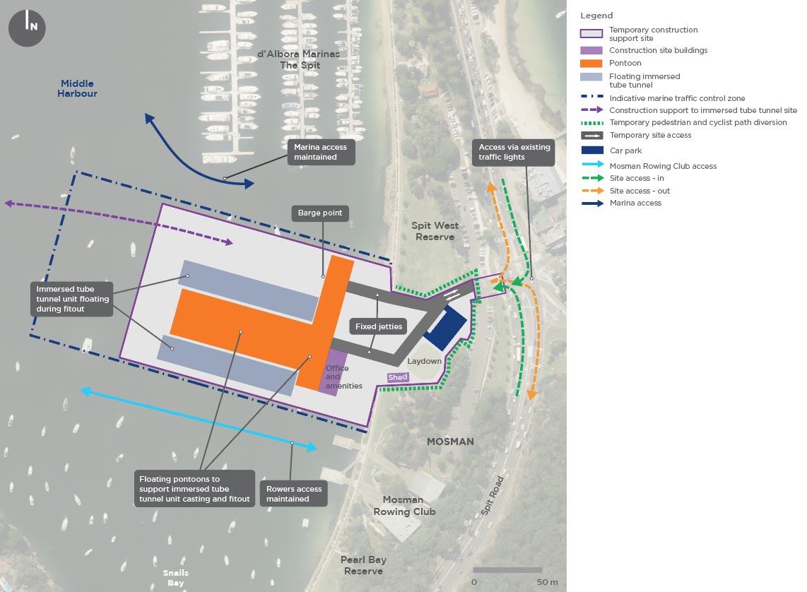
These temporary sites will be water based, serviced by barges from the Spit West Reserve site at Mosman.
Spit West Reserve
We will be setting up a temporary land- and marine-based construction support site at Spit West Reserve.
The land-based site at Spit West Reserve will provide a small car park, access road, laydown area, office, amenities and storage to support construction work.
The marine-based site will include a temporary floating immersed tube tunnel casting facility that will be connected to Spit West Reserve by two temporary jetties.
We will be setting up a temporary construction site at Wakehurst Parkway on land within Sydney Water’s Bantry Bay Reservoir site, west of Wakehurst Parkway Golf Course.
This site will support the construction of the tunnel ramps between Wakehurst Parkway and the underground connection to the main tunnel.
We will be setting up a temporary construction site at Flat Rock Reserve, on the eastern side of Flat Rock Drive. We will use this site to support the excavation and fitout of the tunnels west towards Artarmon, east towards Middle Harbour and south towards Cammeray.
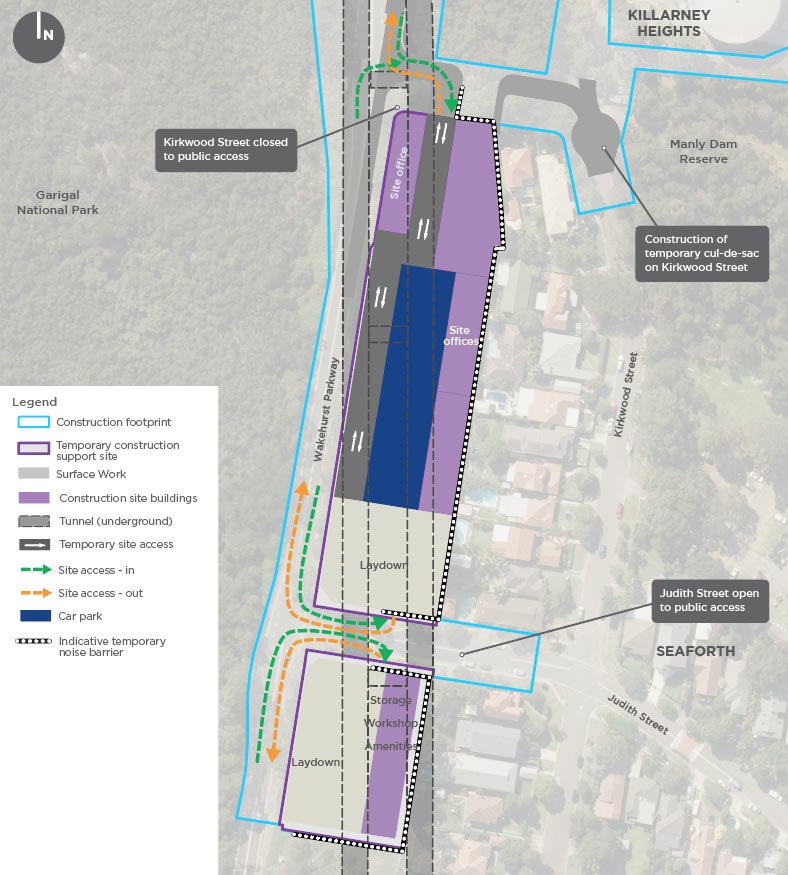
We will be setting up a temporary construction support site along Wakehurst Parkway to support the upgrade of Wakehurst Parkway, the construction of the cut and cover structure, trough and motorway facilities, and provide additional support for tunnelling work at the Wakehurst Parkway east construction support site.
We will return an area equivalent to around 90 per cent of the current open space as new and improved public open space and recreation facilities for the community at Balgowlah.
We are working collaboratively with the Northern Beaches Council and plan to progressively deliver some of the recreational precinct for you to use before construction is complete.
We will have a dedicated consultation period to give you an opportunity to have your say on the final layout of the sporting and recreational facilities.
We will start this process in 2021 once the EIS public exhibition has closed and well in advance of construction starting.
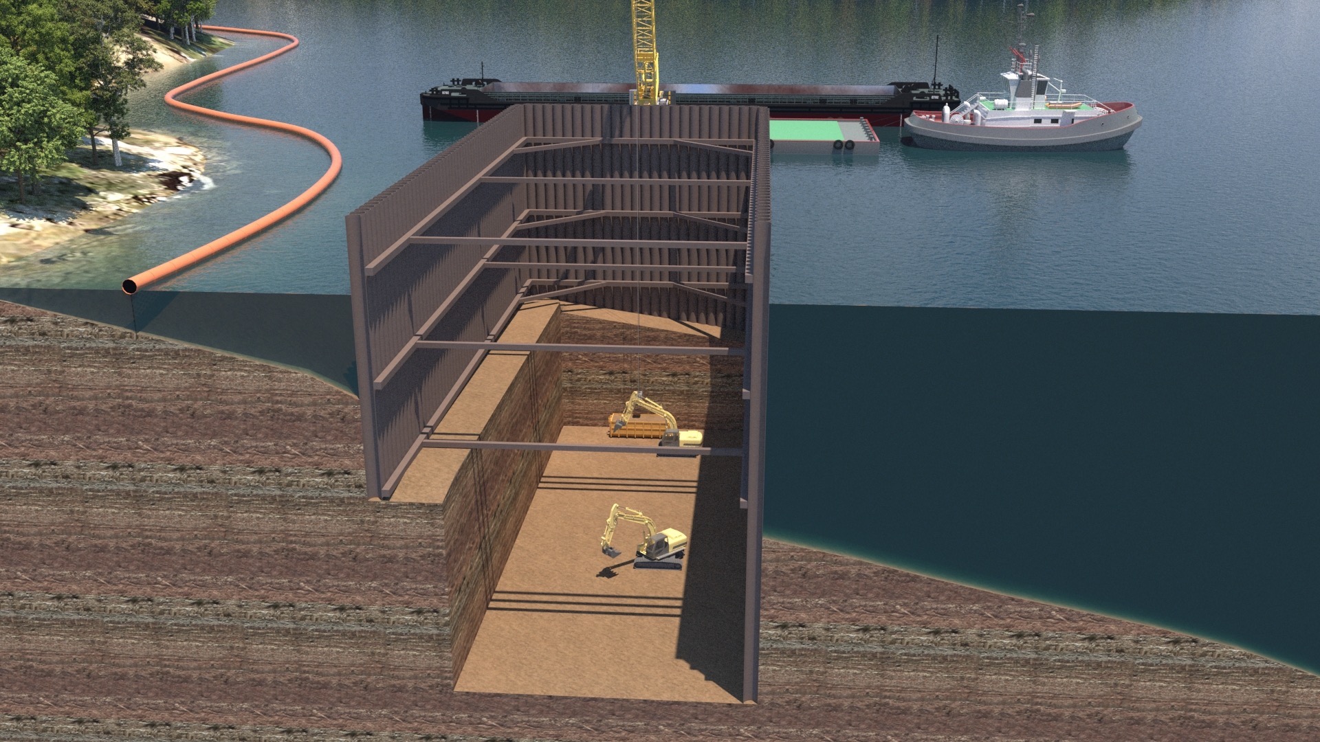
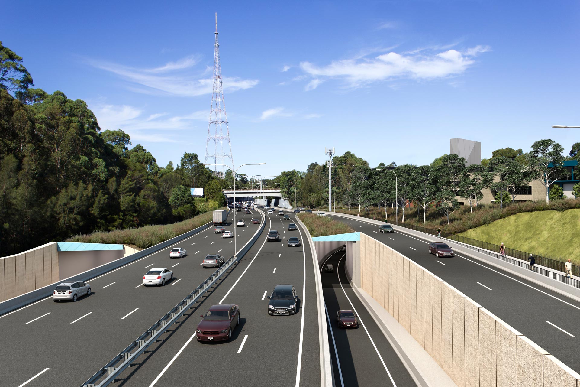
We will be using twin immersed tube tunnels to cross Middle Harbour. Immersed tube tunnels have been built in many locations around the world, including for our existing Sydney Harbour Tunnel.
This technique will allow us to safely and efficiently build the crossing of Middle Harbour.
We will be building a temporary cofferdam at each end of the harbour crossing, one off the shoreline of Northbridge and the other off the shoreline of Seaforth. These temporary cofferdams are required so we can build the connection between the land tunnel and the immersed tube tunnels.
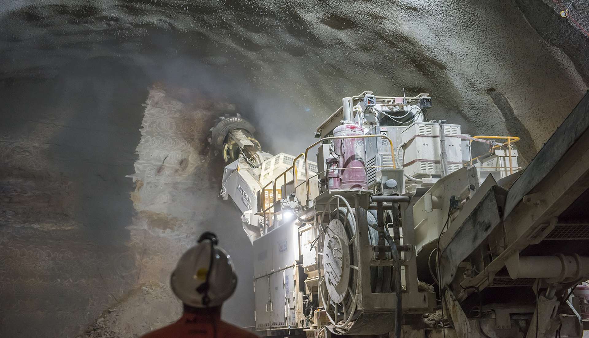
We will be tunnelling using roadheaders. Roadheaders are extremely powerful and advanced rock-cutting machines designed to excavate tunnels and caverns. They are almost always used for tunnelling on major oad projects in Sydney including the recently completed WestConnex M8, New M4 tunnels and NorthConnex.
Rock hammering and rock saws may be used in some areas for excavation of the tunnels, cross passages and areas of sandstone within the cut and cover and trough structures.
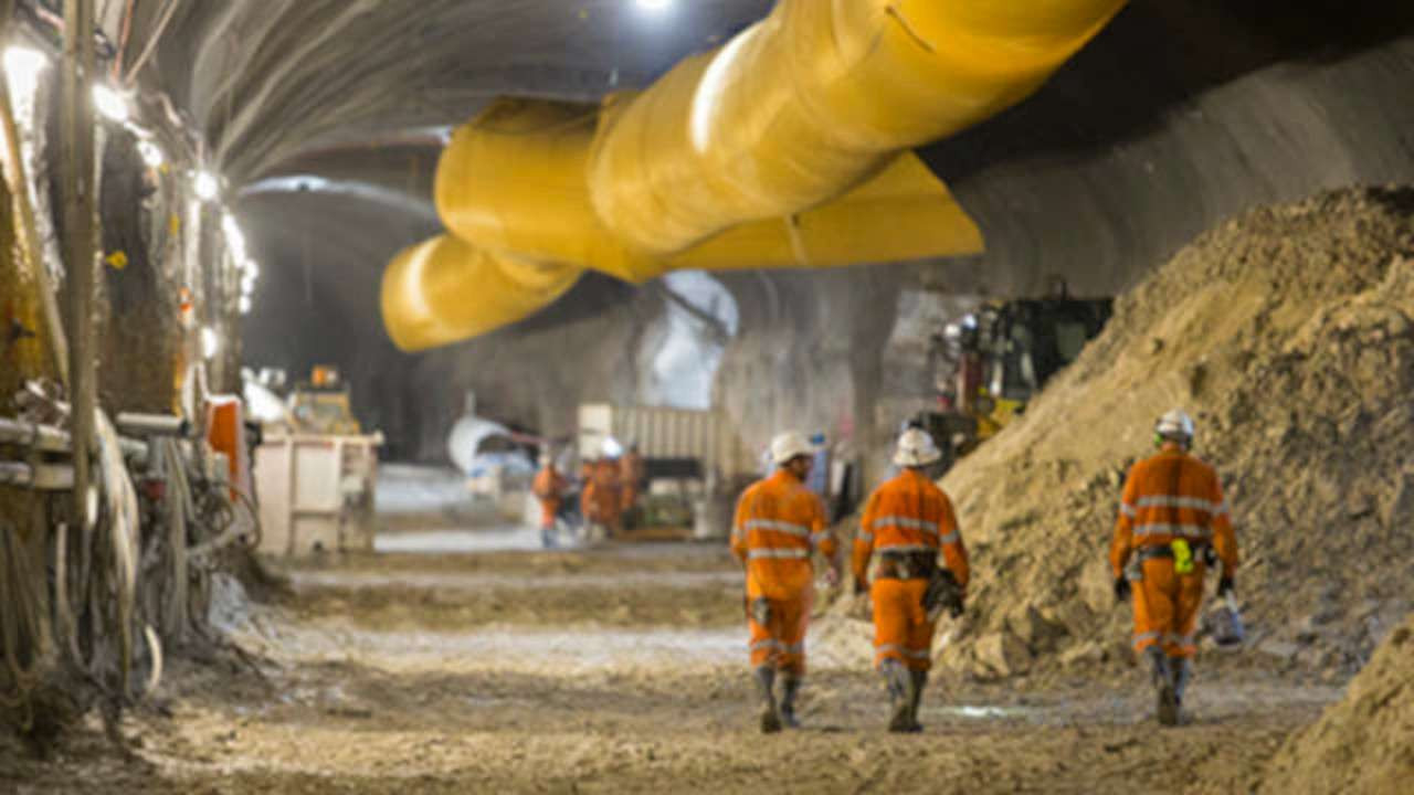
Before we start building a detailed Construction Environment Management Plan (CEMP) will be developed to detail how the project will preserve, protect and manage any potential impact to the local environment.
On land
We will be using trucks to transport most of the spoil from the temporary tunnel sites and surface works. Before these materials leave the site, they will be classified in line with the NSW and Australian standards and guidelines. We expect most of this material will be re-used at development construction and remediation sites across Greater Sydney. Any materials not suitable or re-use will be taken to a licenced waste facility.
In the water
Dredged and excavated materials removed from Middle Harbour will be transported via barge to either the designated offshore disposal site or a designated loadout facility and then transported by truck, depending on the type of material removed. We have submitted an application to the Commonwealth Department of Agriculture, Water and the Environment for offshore disposal of suitable dredged and excavated material.
We thank you for the feedback you have provided so far. This has already helped us make a number of positive improvements to the project. Your input, remains integral to the next stage of the project’s design, so we encourage you to make a submission on the EIS.
Submissions must be made directly to the Department of Planning, Industry and Environment (DPIE) before midnight Monday 1 March 2021. The exhibition period of 61 days* is in line with the Environmental Impact Statement exhibition period for the WestConnex M4-M5 Link and Western Harbour Tunnel and Warringah Freeway Upgrade projects.
*The period between 20 December 2020 and 10 January 2021 (inclusive) is not included in the 61 days.
Make a submission How to make a submission fact sheet Learn how to make a submission
This dedicated interactive portal contains the latest information, maps and videos about the Beaches Link and Gore Hill Freeway Connection project.
If you are looking for information about the Warringah Freeway Upgrade or Western Harbour Tunnel, please visit the dedicated project portals:
Warringah Freeway Upgrade portal Western Harbour Tunnel portal
If you have any complaints or enquiries, please contact us.
Explore our interactive map to see the project alignment and key information about the proposed design and construction of the project.
Please note: This interactive map contains information from the Beaches Link and Gore Hill Freeway Connection Environmental Impact Statement (EIS) which was published in December 2020. Since then, our project design and planning has continued to progress, including the release of the Submissions and Preferred Infrastructure Reports in November 2021.
For the latest project information, please visit the documents section of our portal or contact our team.
To make a submission on the Beaches Link and Gore Hill Freeway Connection Environmental Impact Statement, use the online form. All submissions received will be placed on the DPIE website.
The public consultation and submission period closes on 11.59pm, Monday 1 March 2021.
For a video tutorial on how to make a submission on the DPIE website click here.
To watch a video tutorial about how you can subscribe to receive timely, project-related alerts click here.
If you want DPIE to delete your personal information before publication, please make this clear at the top of your letter.
We understand noise can be a source of disruption to local communities during the construction and operation of major road projects. To minimise the impact of our project on local residents, we are delivering at-property noise treatment to eligible properties. Noise treatment refers to architectural acoustic measures which aim to improve the sound resistance of properties, such as window and door upgrades.
We have developed a Noise Insulation Program which outlines the criteria and process for delivering noise treatment to affected properties as part of the project.
Providing at-property treatment is a complex process and involves a number of different steps. To learn more, see our fact sheet.
We are starting the process of delivering noise treatment before the project is approved so residents benefit from reduced noise as early as possible.
We are committed to continuing to work with you and to adapting to the changing circumstances around COVID-19.
Reservations for the February 2021 sessions have now closed. You can watch the recorded sessions online by clicking on the button below.
We are happy to coordinate virtual tutorials to explain the tools and techniques of the model as required.
Please raise a question in the RFT Data Room should you require any additional support.
The EIS assesses the potential environmental and social impacts of the Western Harbour Tunnel and Warringah Freeway Upgrade during construction and operation. The EIS also includes strategies to avoid, mitigate and manage the potential impacts of the project.
In the EIS, we cover topics such as traffic and transport, air quality, noise and vibration, construction and biodiversity impacts.
The NSW Department of Planning, Industry and Environment (DPIE) placed the EIS on exhibition from 29 January to 30 March 2020. This closing date was extended from 12 March following feedback from the community. During this time everyone had the opportunity to make submissions on the project. We are now working on a submissions report to respond to the issues raised. This report will be made public. All submissions made to DPIE are available on their website.
Have your say on Western Harbour Tunnel and Warringah Freeway Upgrade
How to make an online submission:
How to make a hard copy submission:
You can submit a hard copy of your submission. If you want DPIE to delete your personal information before publication, please make this clear at the top of your letter. You need to include:
You can hand deliver your submission to DPIE’s office, located at:
4 Parramatta Square, 12 Darcy Street
Parramatta NSW 2150
You can post your submission to:
Attention: Director, Transport Assessments
Planning & Assessment, Department of Planning
Industry and Environment
Locked Bag 5022
Parramatta NSW 2124
Submissions must be received by DPIE before midnight 30 March 2020.
Select the topics you are interested in reading about
Select from topics of interest above


Transport for NSW (“we”) are collecting your personal information in connection with public consultation on the Western Harbour Tunnel, Warringah Freeway Upgrade and Beaches Link projects (“the Program”). We will retain and use this information for consultation purposes, including communications and analysis in connection with the Program.
We may share your submission or complaint with another NSW government agency where relevant having regard to the nature of the submission or complaint. Otherwise, except for anonymous information which does not identify you, we will not publish or disclose your personal information to any third parties without your consent unless authorised by law.
Providing your personal information is voluntary but if you do not provide it we may not include you on our stakeholder database and you might miss further consultation opportunities.
Your personal information will be held and managed by Transport for NSW in accordance with the Privacy and Personal Information Protection Act 1998 and you can contact us to access or correct it. Please email us at whtbl@transport.nsw.gov.au, write to us at Transport for NSW, Locked Bag 928, North Sydney NSW 2059, or call us on 1800 931 189.
This statement relates to content available on the Transport for NSW Beaches Link and Gore Hill Freeway Connection portal (https://caportal.com.au/rms/bl).
This website has been developed with the aim to be available to the widest possible audience, including those using assistive technology or accessibility features.
Ongoing monitoring and development is part of our strategy and we strive to comply with W3C's Web Content Accessibility Guidelines.
At times, we publish documents and publications received from third parties. These third party documents may not adhere to the standards followed by Transport for NSW.
If you have any questions or comments about this statement or have problems accessing information or functions on this site please contact us.
This site contains information in portable document format (PDF). These files are made available so information is easy to download and is portable.
Some documents on this website may not conform with WCAG 2.0. If you encounter any problems accessing documents in PDF format please contact us.
Transport for NSW acknowledges the traditional owners and custodians of the land, and respects Elders past and present.